Poole tide times
Poole tide forecast — heights relative to MSL.
Today's tide times for Poole
Tide times at Poole on Friday, 31 July 2026: first high tide at 01:00, first low tide at 04:26, second high tide at 09:00, second low tide at 16:39, third high tide at 20:48. Sunrise 05:31, sunset 20:56.
Tide chart for Poole
24-hour cosine-interpolated curve around the present moment. Heights relative to MSL. Predictions: Predictions: Open-Meteo Marine (MeteoFrance SMOC, 0.08° grid).
Sun, moon and conditions on Fri 31 Jul
Snapshot at build time — refreshes daily. Sea state from Open-Meteo Marine.
Highs and lows next 7 days
Every predicted high and low for the next week, with the daily tidal coefficient (0–120; higher = bigger swing, > 95 means stronger currents).
Other spots nearby
The three closest curated TideTurtle locations to Poole, measured by great-circle distance.
Today's solunar windows
Solunar tradition: major periods are the ≈3h windows around moon transit and opposition; minor are ≈2h around moonrise and moonset. Pair with the local tide stage and wind for the best read.
Cycle dates near Poole
Next spring tide on Sun 02 Aug (range 1.8m / 5.8ft). Next neap on Thu 06 Aug.
Spring tides cluster around new and full moons (biggest swings). Neap tides land on quarter moons (smallest swings). See the spring tide and neap tide glossary entries for the why.
About tides at Poole
A short guide to the coastline at Poole — geography, sea state, and what the tide is actually doing under your feet.
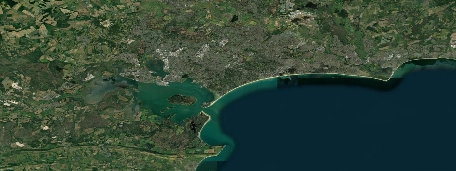
Poole Harbour is one of the largest natural harbours in the world by surface area — roughly 36 square kilometres of sheltered, shallow water occupying a drowned river valley behind a narrow shingle entrance that barely exceeds 100 metres at its narrowest point between the Sandbanks peninsula and the Shell Bay shore on the Studland side. The geography creates a tidal situation that baffles visitors who arrive expecting standard English Channel conditions. 0 metres — enough to shift the character of the beach and the approach to the Studland sand dunes across a day, but nothing unusual for the south coast.
Step inside the harbour entrance and the story changes completely. The restriction at Sandbanks limits how fast water can flow in or out, and the harbour's large surface area means the volume of water that needs to move to fill or drain it is substantial. The result is that the harbour simply cannot keep pace with the ocean tide outside.
6 metres — the tidal signal has been attenuated by more than two-thirds within a few hundred metres of the entrance. Inside the harbour, tide is almost irrelevant for practical purposes. What this means in practice: the extensive shallows of Holes Bay to the north and Lytchett Bay to the northwest dry out at low water but the variation across the tidal cycle is small enough that dinghy sailing and kayaking remain viable across a wide range of states.
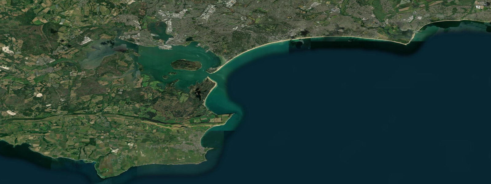
The 150 or so islands and mudflat islets within the harbour — including Brownsea Island, the largest, with its National Trust woodland and Scouting historical significance — sit in stable, low-energy water. The Sandbanks channel between the entrance and the main harbour, however, is a very different proposition. On spring tides the ebb and flood through this 100-metre gap runs at 3 to 4 knots — currents that are immediately obvious to anyone swimming near the entrance, kayaking across the channel, or watching the Sandbanks chain ferry work against the flow.
The Sandbanks chain ferry runs continuously across this gap, connecting the Sandbanks peninsula road to Shell Bay and Studland on the Isle of Purbeck — a five-minute crossing that would be a long drive around without it. The ferry is designed to handle the current. Swimmers and kayakers crossing the channel outside the ferry lanes should be aware that the current is fast and the commercial ferry, along with private motor craft, uses the same narrow water.
Poole town itself sits on a peninsula inside the harbour, the old quay lined with restaurants, chandleries, and the Poole Pottery building. The low tidal range means the quayside stays accessible throughout the cycle — there is no stranding at low water in the way that would affect a harbour with a 4-metre range. The water taxis running between Poole Quay, Brownsea Island, and Sandbanks operate on this basis.
Studland Bay, just outside the harbour to the east, offers a different experience — the full English Channel range on a sheltered, northwest-facing sand beach with the Old Harry Rocks chalk stacks marking the Handfast Point headland and the beginning of the Jurassic Coast. The Jurassic Coast designation covers 155 kilometres of Dorset and Devon shoreline, all of it accessible by the South West Coast Path. At Studland, the beach at low water gives access to sandbars and shallows that are submerged at high — a particular draw for families and shore anglers targeting bass in the gullies between the sand ridges on the flood tide.
Portland Bill, 20 kilometres west along the coast past Weymouth, generates the Portland Race — a zone of tidal overfalls where the stream running around the Bill at up to 7 knots on springs meets itself and creates standing waves. The Race is marked on Admiralty charts and is avoided by all small craft, particularly near springs on a fresh wind-against-tide day when the overfalls can be dangerous. Chesil Beach, the 18-kilometre tombolo connecting Portland to the mainland, is the classic Dorset shore-angling location — steep shingle with deep water immediately off the beach, producing good bass, cod, and dogfish results in autumn and winter.
The Fleet lagoon behind Chesil is another enclosed, nearly atidal water body similar in principle to Poole Harbour, though much smaller and without a significant harbour current. Tide predictions for this page come from Open-Meteo Marine, a global gridded model — model-derived, not from a local gauge. 3 metres on height.
For Poole specifically, the outside-harbour and inside-harbour tide conditions differ significantly; the model prediction represents the broader Poole Bay and harbour area. Authoritative data comes from the UK Hydrographic Office Admiralty Tide Tables and the National Tidal and Sea Level Facility (NTSLF).
Tide questions about Poole
Quick answers to the most common questions about tide times, range, and water access at Poole.
Why is the tidal range inside Poole Harbour so small?
Poole Harbour covers roughly 36 square kilometres but connects to the sea through a channel barely 100 metres wide at Sandbanks. The restriction limits the flow rate of water in and out, and the harbour's large surface area means a huge volume of water needs to move to change the level significantly. The result is a resonance effect — the tidal wave cannot push enough water through the gap fast enough to follow the ocean tide outside. Inside the harbour, the spring range is approximately 0.5 to 0.6 metres. Outside in Studland Bay and the English Channel, the normal range is 1.5 to 2.0 metres. This attenuation happens within a few hundred metres of the Sandbanks entrance. A similar effect, though for different reasons, operates at other enclosed harbours like The Fleet behind Chesil Beach.
What is the tidal range at Poole?
Outside the harbour entrance — in Poole Bay, Studland Bay, and the open English Channel — the tidal range is 1.5 to 2.0 metres on springs, dropping to around 0.7 to 1.0 metres on neaps. Inside Poole Harbour, the range is approximately 0.5 to 0.6 metres on springs due to the harbour resonance created by the narrow Sandbanks entrance. Two high and two low tides occur each day. Open-Meteo Marine predictions shown here are model-derived and typically accurate within plus or minus 45 minutes on timing and 0.2 to 0.3 metres on height. The UK Hydrographic Office Admiralty Tide Tables provide authoritative data for both inside and outside the harbour.
Where does the Poole tide data come from?
Predictions on this page come from Open-Meteo Marine, a free global gridded ocean model. Data is model-derived rather than from a local gauge. For authoritative tide data covering both Poole Bay and the inside of Poole Harbour: the UK Hydrographic Office (UKHO) publishes the Admiralty Tide Tables, and the National Tidal and Sea Level Facility (NTSLF) maintains gauge data for the Poole/Bournemouth area. The Environment Agency monitors water quality and flooding risk in the harbour. For the Sandbanks channel specifically — where tidal currents, not just heights, are the operational variable — Admiralty chart SC5601 covers the Solent and Approaches including the Poole entrance.
What activities are affected by the tide at Poole and Sandbanks?
The Sandbanks entrance channel sees 3 to 4 knot tidal currents on springs — the primary tidal consideration for anyone kayaking across the harbour mouth, swimming near the entrance, or launching a dinghy through the gap. The chain ferry operates across this channel and has right of way. Inside the harbour, the low tidal range (0.5 to 0.6 metres) means dinghy sailing, kayaking, and paddleboarding remain viable across most of the tidal cycle. Holes Bay and Lytchett Bay shallows dry at low water but the variation is small. Outside at Studland Bay, the fuller English Channel range makes low-tide sandbar exploration interesting for beach visitors. Shore anglers at Studland and along the Purbeck coast target bass on the flood tide in the gullies behind the sandbars.
Is the Sandbanks ferry affected by the tide?
The Sandbanks chain ferry operates independently of tide state — it runs continuously across the harbour entrance between Sandbanks and Shell Bay and is not tide-restricted. However, the tidal current through the Sandbanks channel does affect its operation: on spring tides the ebb and flood reach 3 to 4 knots, and the chain-guided ferry is designed to handle that cross-current. The crossing takes around five minutes in normal conditions. Tidal current, not water depth, is the relevant variable here — inside the harbour the low range means adequate depth is maintained at all states for the ferry's draught. Pedestrians crossing outside the ferry lanes should note the current is fast and the channel carries commercial motor traffic. The disclaimer applies to all navigation here: this page shows model-derived tide predictions, not a harbour-operations briefing.
8-day tide table — Poole
Heights relative to MSL. Predictions: Open-Meteo Marine (MeteoFrance SMOC, 0.08° grid) — heights relative to MSL (not chart datum / LAT). Model-derived.
| Day | Type | Time | Height |
|---|---|---|---|
| Fri 31 Jul | High | 01:00 | -0.5m / -1.7ft |
| Low | 04:26 | -1.2m / -4.0ft | |
| High | 09:00 | 0.0m / 0.1ft | |
| Low | 16:39 | -0.9m / -3.1ft | |
| High | 20:48 | 0.4m / 1.2ft | |
| Sat 01 Aug | Low | 05:03 | -1.3m / -4.3ft |
| High | 09:15 | 0.0m / 0.1ft | |
| Low | 17:15 | -0.9m / -2.9ft | |
| High | 21:10 | 0.4m / 1.4ft | |
| Sun 02 Aug | Low | 05:42 | -1.3m / -4.4ft |
| High | 09:46 | 0.1m / 0.3ft | |
| Low | 17:56 | -0.8m / -2.6ft | |
| High | 21:41 | 0.4m / 1.5ft | |
| Mon 03 Aug | Low | 06:19 | -1.0m / -3.4ft |
| High | 10:10 | 0.3m / 0.9ft | |
| Low | 18:40 | -0.7m / -2.4ft | |
| High | 22:15 | 0.4m / 1.5ft | |
| Tue 04 Aug | Low | 07:02 | -1.0m / -3.2ft |
| High | 22:55 | 0.2m / 0.8ft | |
| Wed 05 Aug | Low | 07:44 | -0.9m / -3.1ft |
| High | 11:23 | 0.1m / 0.3ft | |
| Low | 14:14 | -0.3m / -1.1ft | |
| High | 15:10 | -0.3m / -0.9ft | |
| Low | 20:12 | -0.6m / -2.1ft | |
| High | 23:34 | 0.1m / 0.4ft | |
| Thu 06 Aug | Low | 08:35 | -0.8m / -2.6ft |
| High | 12:08 | 0.0m / 0.1ft | |
| Low | 14:43 | -0.3m / -1.0ft | |
| High | 16:12 | -0.2m / -0.7ft | |
| Low | 21:14 | -0.6m / -1.8ft | |
| Fri 07 Aug | High | 00:00 | -0.0m / -0.1ft |