Panama City (Pacific) tide times
Panama City (Pacific) tide forecast — heights relative to MSL.
Today's tide times for Panama City (Pacific)
Tide times at Panama City (Pacific) on Friday, 31 July 2026: first high tide at 04:31am, first low tide at 10:37am, second high tide at 04:42pm, second low tide at 10:51pm. Sunrise 06:09am, sunset 06:39pm.
Tide chart for Panama City (Pacific)
24-hour cosine-interpolated curve around the present moment. Heights relative to MSL. Predictions: Predictions: Open-Meteo Marine (MeteoFrance SMOC, 0.08° grid).
Sun, moon and conditions on Fri 31 Jul
Snapshot at build time — refreshes daily. Sea state from Open-Meteo Marine.
Highs and lows next 7 days
Every predicted high and low for the next week, with the daily tidal coefficient (0–120; higher = bigger swing, > 95 means stronger currents).
Other spots nearby
The three closest curated TideTurtle locations to Panama City (Pacific), measured by great-circle distance.
Today's solunar windows
Solunar tradition: major periods are the ≈3h windows around moon transit and opposition; minor are ≈2h around moonrise and moonset. Pair with the local tide stage and wind for the best read.
Cycle dates near Panama City (Pacific)
Next spring tide on Sat 01 Aug (range 4.3m). Last neap on Thu 30 Jul. Next neap on Wed 05 Aug.
Spring tides cluster around new and full moons (biggest swings). Neap tides land on quarter moons (smallest swings). See the spring tide and neap tide glossary entries for the why.
About tides at Panama City (Pacific)
A short guide to the coastline at Panama City (Pacific) — geography, sea state, and what the tide is actually doing under your feet.
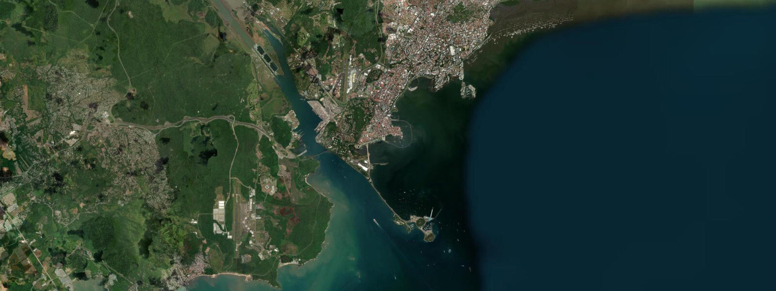
Panama City sits at the Pacific entrance to the Panama Canal, where the Bay of Panama — the inland reach of the Gulf of Panama — receives a tidal signal that is, by Central American standards, genuinely large. The mean tidal range at the Pacific entrance runs 4 to 5 metres, driven by the resonant geometry of the Gulf of Panama amplifying the eastern Pacific tidal forcing. On the biggest spring tides around new and full moons, the range can approach 6 metres, exposing wide intertidal shelves along the Amador Causeway and the beaches of the Arraiján coast west of the city.
5 to 3 metres. The Amador Causeway, the 3-kilometre road built across the four Amador islands using rock excavated from the Canal in the early 1900s, runs parallel to the Pacific entrance channel and gives the clearest vantage point in the city for watching the tidal swing. At low water on a spring tide, the rock shelves along the causeway islands drop well below the sea wall base and the exposed reef flat extends out into the bay.
At high water on a spring tide, the same shelves are submerged to two or three metres. The swing is visible, measurable, and constant — a useful orientation point for anyone new to the Pacific Panama tidal regime. The Pacific entrance of the Canal itself — the Miraflores Locks, visible from the Miraflores visitor centre a short drive inland from Balboa — manages water level against Gatun Lake's freshwater elevation, not against the Pacific tide.
The lock system allows vessels transiting from the Pacific to climb 26 metres to Gatun Lake level in three lock chambers, and then descend again on the Atlantic side. The vessels waiting in the anchorage in the Gulf of Panama north of the entrance channel are subject to the full Pacific tidal swing at their anchor; port pilots time vessel movements through the Canal entrance to the tidal and current conditions in the approach channel. The Casco Viejo historic district occupies a small peninsula on the eastern shore of the bay, south of the Canal entrance.
The seawall around the peninsula's perimeter — the Paseo de las Bóvedas, the old fortification terrace — gives a sea-level view of the tidal change. At low water on a large spring tide, the exposed rock and intertidal biota visible from the wall represent the full 4-to-5-metre drop from the previous high. Photographers find the golden-hour light on the old Casco walls at low-water dawn and dusk compelling, with the shallow flats and the distant container ships at anchor in the gulf providing context the city's skyline rarely offers from land.
The Miraflores causeway beach and the Amador islands are used by open-water swimmers who time entries to avoid the strongest current phases — the ebb and flood run noticeably in the bay, and the mid-tide current through the causeway passages between the islands requires attention. Kayakers on the bay also plan around the mid-tide current phase: the hour or two at the top of the tide and the bottom of the tide, when the current is minimal, makes for the most relaxed paddle around the causeway islands and into the mangrove fringe at the bay's southern edge. The intertidal mud flats and mangrove margins at the southern end of the bay, around the Cinta Costera shoreline and the Bella Vista reclamation, host large concentrations of wading birds — brown pelicans, magnificent frigatebirds, and migrating shorebirds using the Pacific flyway — particularly at low tide when the mud flat is exposed.
The Panama Canal Authority (ACP) and INAMEH maintain the sea-level gauges at the Pacific entrance and across the Gulf of Panama. Those are the authoritative references for harbour pilotage, vessel scheduling, and any tide-dependent activity. The predictions on this page come from Open-Meteo Marine, a gridded global ocean model that estimates tidal height from oceanographic equations across a geographic grid rather than from harmonic analysis at a calibrated Pacific-entrance gauge.
3 metres on height — model-derived, not a local gauge. On a coast with a 4-to-5-metre mean range, the height uncertainty is a smaller fraction of the total signal than on microtidal coasts, but timing errors of up to 45 minutes are still meaningful when planning around the fast-moving mid-tide current phase.
Tide questions about Panama City (Pacific)
Quick answers to the most common questions about tide times, range, and water access at Panama City (Pacific).
When is the next high tide at Panama City (Pacific)?
The tide times at the top of this page show the next predicted high at the Pacific entrance, displayed in Panama Standard Time (EST, UTC-5, no daylight saving time). Panama City's Pacific coast is semidiurnal — two highs and two lows per day, roughly 12 hours 25 minutes between consecutive highs. The range is large by Central American standards: 4 to 5 metres mean, approaching 6 metres on the largest spring tides. Neap tides at the quarter moons compress the swing but typically stay above 2.5 metres. The Panama Canal Authority and INAMEH maintain the authoritative gauge at the Pacific entrance.
Why is the tidal range at Panama City so much larger than the Caribbean side?
The Gulf of Panama acts as a resonant basin that amplifies the incoming Pacific tidal wave. The geometry of the gulf — its width, depth, and the shape of the coast — produces a natural resonance that adds to the eastern Pacific tidal signal and results in a 4-to-5-metre mean range on the Pacific side. Cross the isthmus to Bocas del Toro on the Caribbean coast and the range drops to 0.3 to 0.5 metres — the low-range Caribbean microtidal regime. Same isthmus, same latitude, two completely different tidal worlds separated by 77 kilometres of land.
Where does the tide data for Panama City (Pacific) come from?
Predictions on this page come from Open-Meteo Marine, a free gridded global ocean model. It estimates tidal height from oceanographic equations applied across a geographic grid, not from harmonic analysis of a dedicated Pacific-entrance gauge record — accuracy is typically within plus or minus 45 minutes on timing and 0.2 to 0.3 metres on height — model-derived, not a local gauge. For a 4-to-5-metre mean range coast, the height uncertainty is a smaller relative fraction than on microtidal coasts, but timing offsets of up to 45 minutes matter when planning around fast mid-tide currents. The Panama Canal Authority (ACP) and INAMEH maintain the authoritative sea-level gauge at the Pacific entrance.
Is the tidal current dangerous for swimming or kayaking in Panama Bay?
The mid-tide current phase — the period when the 4-to-5-metre tidal range is moving fastest through the bay and the causeway passages — can run noticeably and requires attention from swimmers and kayakers. The safest windows for open-water swimming and casual kayaking around the Amador Causeway islands are the roughly 60-to-90 minutes at the top and bottom of the tidal cycle, when the current is minimal. During the fast ebb or flood phase, water moves through the causeway passages and along the bay's edges with enough force to set a swimmer off course. Local open-water swimming groups time their bay swims around the slack windows — follow their schedule rather than improvising against the mid-tide flow.
Does the Panama Canal tide schedule affect vessel departures?
The Canal transit itself is managed against Gatun Lake's freshwater water level, not the Pacific tidal signal — vessels are locked up and down independent of the tide. However, the approach channel from the anchorage in the Gulf of Panama to the Miraflores Locks entrance crosses the full Pacific tidal zone, and pilots factor tidal phase and current direction into departure timing from the anchorage, particularly for deep-draught vessels with limited underkeel clearance. The Panama Canal Authority (ACP) publishes the official approach-channel conditions and is the sole authority for Canal transit scheduling.
7-day tide table — Panama City (Pacific)
Heights relative to MSL. Predictions: Open-Meteo Marine (MeteoFrance SMOC, 0.08° grid) — heights relative to MSL (not chart datum / LAT). Model-derived.
| Day | Type | Time | Height |
|---|---|---|---|
| Fri 31 Jul | High | 04:31 | 2.3m |
| Low | 10:37 | -1.4m | |
| High | 16:42 | 2.4m | |
| Low | 22:51 | -1.8m | |
| Sat 01 Aug | High | 05:10 | 2.5m |
| Low | 11:10 | -1.5m | |
| High | 17:19 | 2.4m | |
| Low | 23:22 | -1.7m | |
| Sun 02 Aug | High | 05:44 | 2.6m |
| Low | 11:48 | -1.5m | |
| High | 17:55 | 2.5m | |
| Mon 03 Aug | Low | 00:00 | -1.6m |
| High | 06:17 | 2.6m | |
| Tue 04 Aug | Low | 00:42 | -1.5m |
| High | 06:50 | 2.6m | |
| Low | 13:16 | -1.4m | |
| High | 19:08 | 2.3m | |
| Wed 05 Aug | Low | 01:31 | -1.4m |
| High | 07:27 | 2.5m | |
| Low | 14:08 | -1.3m | |
| High | 19:50 | 2.0m | |
| Thu 06 Aug | Low | 02:23 | -1.2m |
| High | 08:10 | 2.3m | |
| Low | 15:02 | -1.3m | |
| High | 18:00 | 0.5m |