Kaikōura tide times
Kaikōura tide forecast — heights relative to MSL.
Tide chart for Kaikōura
24-hour cosine-interpolated curve around the present moment. Heights relative to MSL. Predictions: Predictions: Open-Meteo Marine (MeteoFrance SMOC, 0.08° grid).
Sun, moon and conditions on Tue 23 Jun
Snapshot at build time — refreshes daily. Sea state from Open-Meteo Marine.
Highs and lows next 7 days
Every predicted high and low for the next week, with the daily tidal coefficient (0–120; higher = bigger swing, > 95 means stronger currents).
Other spots nearby
The three closest curated TideTurtle locations to Kaikōura, measured by great-circle distance.
Today's solunar windows
Solunar tradition: major periods are the ≈3h windows around moon transit and opposition; minor are ≈2h around moonrise and moonset. Pair with the local tide stage and wind for the best read.
Cycle dates near Kaikōura
Next spring tide on Mon 22 Jun (range 1.4m). Next neap on Sat 27 Jun.
Spring tides cluster around new and full moons (biggest swings). Neap tides land on quarter moons (smallest swings). See the spring tide and neap tide glossary entries for the why.
About tides at Kaikōura
A short guide to the coastline at Kaikōura — geography, sea state, and what the tide is actually doing under your feet.
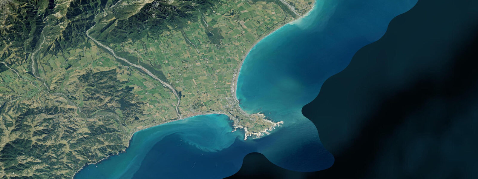
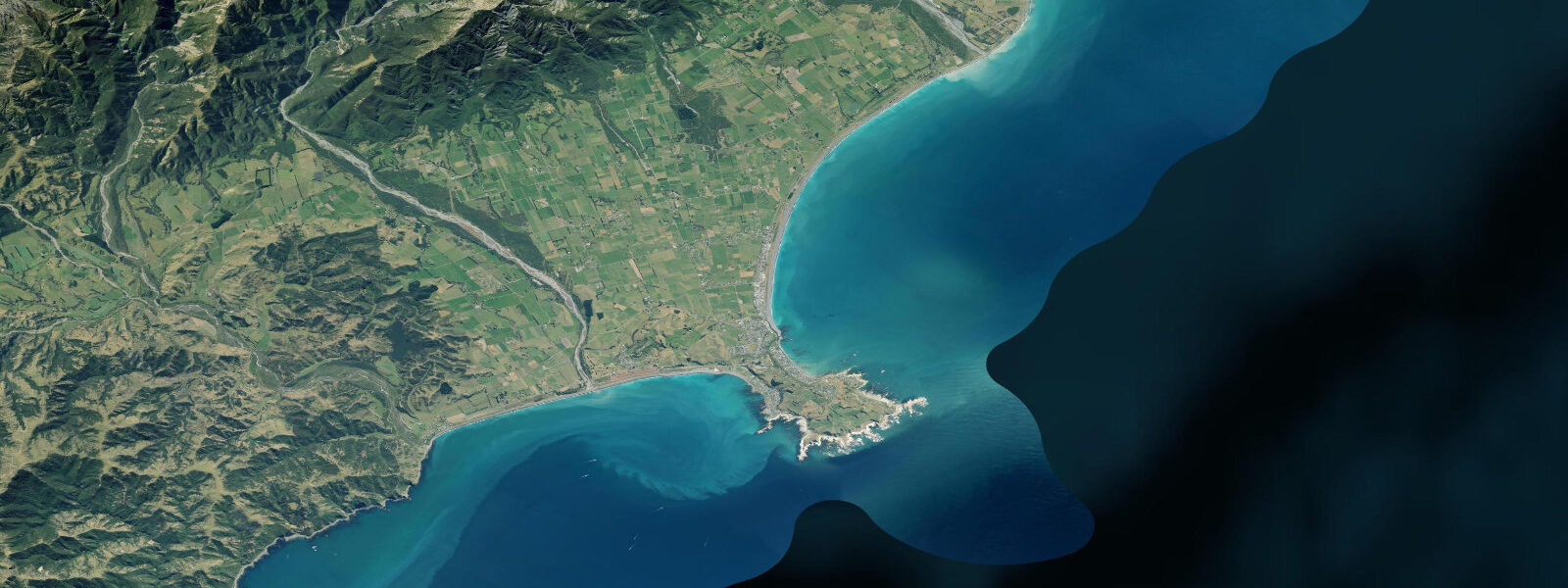
Kaikōura sits on a small marine terrace peninsula on the northeastern South Island coast, where the land meets one of the most dramatic submarine features in the Southwest Pacific. The Hikurangi Trough — a submarine trench that is an extension of the Hikurangi Subduction Zone — drops to 500 m or more just 500 metres offshore of the Kaikōura Peninsula. Cold, nutrient-rich water upwells from this trench year-round, driving a food chain that supports year-round populations of sperm whales, dusky dolphin super-pods of hundreds of individuals, New Zealand fur seals on the peninsula rocks, and dense seabird aggregations including wandering albatross and Hutton's shearwaters. The tidal range at Kaikōura is approximately 1.6 m mean above LAT, semidiurnal.
Sperm whales (Physeter macrocephalus) are present in the Kaikōura Canyon year-round — one of only a handful of locations on earth where deep-diving sperm whales can be reliably found within an hour's boat ride of the coast. The male sperm whales using the canyon are 15–18 m long and dive to 1,000+ m to hunt giant squid in the canyon depths, spending 45 minutes to an hour at depth before returning to the surface to breathe. Whale Watch Kaikōura uses hydrophones deployed from the boat to locate surfacing whales; encounters typically last 15–20 minutes before the whale flukes and dives. A partial refund applies if no whale is sighted — a sightings rate of approximately 95%.
Dusky dolphins (Lagenorhynchus obscurus) occur in Kaikōura waters in pods of dozens to several hundred, making them among the most reliably encountered dolphins in New Zealand. Swim-with-dolphin tours from the town run in the early morning when the dolphins are most active and conditions are calmest before the afternoon southerly builds.
The Kaikōura Peninsula Seal Colony is a permanent haul-out site for New Zealand fur seals (kekeno), accessible by a 30-minute walk from the town on the South Bay road. Hundreds of fur seals rest on the rock platforms year-round; November through January is the pupping season. Maintain 10 m distance — required under the Marine Mammals Protection Act. Commercial snorkelling-with-seals tours operate from South Bay.
The 14 November 2016 Kaikōura earthquake (magnitude 7.8) raised the shoreline by up to 1 m, exposing reef platforms that were previously subtidal and changing the character of the South Bay beach. The coastal highway (SH1) and rail line were both destroyed and required two years to rebuild; both are fully operational. The earthquake's uplift effect is reflected in local surveys — pre-earthquake tide charts may not accurately represent current intertidal exposure.
Predictions on this page come from Open-Meteo Marine, a gridded global ocean model. Accuracy is typically within ±45 minutes on timing and ±0.2–0.3 m on height — model-derived, not from a local gauge. For authoritative New Zealand tide data, consult Land Information New Zealand (LINZ) at linz.govt.nz.
Tide questions about Kaikōura
Quick answers to the most common questions about tide times, range, and water access at Kaikōura.
Why are sperm whales at Kaikōura year-round?
The Hikurangi Trough drops to 500 m or more just 500 metres from the Kaikōura Peninsula. Cold, deep water upwells along the canyon edge, supporting a dense food web — giant squid in the canyon depths are the primary prey of the male sperm whales that use this area. The proximity of deep water to the coast means sperm whales surface within a 20-minute boat ride from the Kaikōura wharf. Most deep-water whale-watching locations require multi-hour offshore passages; Kaikōura's canyon geometry makes reliable sightings available as a day trip.
What changed after the 2016 Kaikōura earthquake?
The 7.8 magnitude earthquake on 14 November 2016 raised the shoreline by up to 1 metre across large sections of the Kaikōura coast. Reef that was previously subtidal became intertidal or exposed at low water; some beach areas narrowed and others expanded. SH1 and the main trunk railway were both destroyed and isolated the town for several months; both were rebuilt and reopened by 2017–2018. Pre-2016 tide charts and surveys do not accurately reflect the current intertidal profile — LINZ has updated its surveys but always check for current chart data.
Can I swim with dolphins at Kaikōura?
Swim-with-dusky-dolphin tours run from Kaikōura township (Encounter Kaikōura and similar operators). Dusky dolphins are highly interactive — they approach swimmers actively and perform aerial acrobatics. Morning tours have the most reliable conditions and most active dolphins. A 5mm wetsuit is provided; water temperature is 12–16°C. Tours are DOC-permitted with limits on participant numbers per pod encounter. Weather and sea conditions cause cancellations — book ahead and allow a spare day if possible.
Where is the Kaikōura fur seal colony?
The Kaikōura Peninsula Seal Colony is at the far end of the peninsula, reached by a 30-minute walk from South Bay along the Peninsula Walkway. Hundreds of New Zealand fur seals haul out on the rock platforms year-round. The walk passes along the rocky coast with sea views of the Seaward Kaikōura Range (snow-capped in winter). November through January is pupping season; pups are curious and will approach walkers — maintain 10 m minimum distance under the Marine Mammals Protection Act. The South Bay side of the peninsula also has a commercial snorkelling-with-seals operation.
How accurate are tide predictions for planning Kaikōura activities?
Predictions here come from Open-Meteo Marine, a global ocean model accurate to within ±45 minutes on timing and ±0.2–0.3 m on height. For general planning — rock platform visits, seal colony timing, selecting a morning versus afternoon dolphin tour — this is adequate. The 2016 earthquake changed the intertidal exposure profile at Kaikōura; the LINZ post-earthquake surveys are the most current reference. For any activity requiring precise tidal knowledge, consult LINZ (linz.govt.nz) for the Kaikōura gauge. These predictions on TideTurtle are a planning guide, not a navigation instrument.
7-day tide table — Kaikōura
Heights relative to MSL. Predictions: Open-Meteo Marine (MeteoFrance SMOC, 0.08° grid) — heights relative to MSL (not chart datum / LAT). Model-derived.
| Day | Type | Time | Height |
|---|---|---|---|
| Tue 23 Jun | Low | 04:12 | -0.6m |
| High | 10:22 | 0.8m | |
| Low | 16:37 | -0.5m | |
| High | 22:51 | 0.8m | |
| Wed 24 Jun | Low | 05:06 | -0.5m |
| High | 23:42 | 0.9m | |
| Thu 25 Jun | Low | 05:54 | -0.4m |
| High | 12:14 | 0.9m | |
| Low | 18:22 | -0.2m | |
| Fri 26 Jun | High | 13:00 | 1.0m |
| Low | 19:18 | -0.2m | |
| Sat 27 Jun | High | 01:20 | 0.9m |
| Low | 07:34 | -0.2m | |
| High | 13:47 | 0.9m | |
| Low | 20:08 | -0.2m | |
| Sun 28 Jun | High | 02:04 | 0.8m |
| Low | 20:54 | -0.4m | |
| Mon 29 Jun | High | 02:55 | 0.6m |
| Low | 09:04 | -0.4m | |
| High | 11:00 | -0.2m |