Inhaca Island tide times
Inhaca Island tide forecast — heights relative to MSL.
Today's tide times for Inhaca Island
Tide times at Inhaca Island on Sunday, 21 June 2026: first low tide at 02:00am, first high tide at 07:51am, second low tide at 02:01pm, second high tide at 08:33pm. Sunrise 06:34am, sunset 05:05pm.
Tide chart for Inhaca Island
24-hour cosine-interpolated curve around the present moment. Heights relative to MSL. Predictions: Predictions: Open-Meteo Marine (MeteoFrance SMOC, 0.08° grid).
Sun, moon and conditions on Sun 21 Jun
Snapshot at build time — refreshes daily. Sea state from Open-Meteo Marine.
Highs and lows next 7 days
Every predicted high and low for the next week, with the daily tidal coefficient (0–120; higher = bigger swing, > 95 means stronger currents).
Other spots nearby
The three closest curated TideTurtle locations to Inhaca Island, measured by great-circle distance.

Today's solunar windows
Solunar tradition: major periods are the ≈3h windows around moon transit and opposition; minor are ≈2h around moonrise and moonset. Pair with the local tide stage and wind for the best read.
Cycle dates near Inhaca Island
Last spring tide on Sun 21 Jun (range 1.5m). Next spring tide on Sat 27 Jun (range 1.4m). Next neap on Wed 24 Jun.
Spring tides cluster around new and full moons (biggest swings). Neap tides land on quarter moons (smallest swings). See the spring tide and neap tide glossary entries for the why.
About tides at Inhaca Island
A short guide to the coastline at Inhaca Island — geography, sea state, and what the tide is actually doing under your feet.
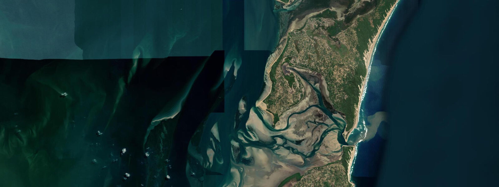
Inhaca Island lies 40 km east of Maputo in Delagoa Bay, accessible by ferry from the Maputo waterfront in approximately 90 minutes or by light aircraft in 15 minutes. The island covers 36 km² and holds roughly 6,000 residents, the marine research station of Eduardo Mondlane University — established in 1950, one of the oldest continuously operating marine biological stations in East Africa — and an ecological reserve covering the northern end of the island.
The contrast between the island's two coasts is among the most instructive demonstrations of tidal influence available anywhere on the Mozambican coast. The western coast faces Maputo Bay across a sheltered channel: mangrove fringes the shoreline, seagrass beds extend across the mudflat below mean water level, and at spring low the intertidal flat runs several hundred metres out from the mangrove edge. The eastern coast faces the open Indian Ocean: an exposed dune beach, no reef protection, full swell exposure from the southeast. The same 3.5 m spring range applies to both sides, but the two coasts read entirely differently because the bottom type, slope, and energy regime differ so completely. Tides here are semidiurnal, with spring range approximately 3.5 m and neap range around 1.7 m.
The seagrass beds on the western intertidal flat are among the most important in southern Mozambique. Green turtles (Chelonia mydas) feed in the seagrass from late afternoon through the morning before retreating to deeper water as the flat shallows toward low water. At high water the flat holds 1.5 to 2.5 m over the seagrass, and turtles can be observed from the shore or from a kayak by anyone willing to move slowly and stay low. Dugong (Dugong dugon) are recorded in the bay's seagrass system, though sightings require patience and local knowledge of the feeding areas. The western intertidal flat at Inhaca is one of the few remaining east African sites where a single visit can produce all three — turtles, dugong, and flamingo — if timed to the flood and the right season.
The bird life on the intertidal flat at low spring is substantial. Crab plovers (Dromas ardeola) and a range of migratory waders use the exposed mudflat from October through March. Greater flamingos (Phoenicopterus roseus) work the shallow edges in small groups. The mangrove on the western coast holds herons, kingfishers, and the mangrove kingfisher (Halcyon senegaloides). The low spring tide, arriving around dawn or dusk (depending on the phase of the semidiurnal cycle), produces the most dramatic intertidal exposure for bird observation. Walking the exposed flat at low spring requires tracking the flood return: the water rises at approximately 0.4 m per hour on springs, and the wide flat can cover quickly.
Whale sharks (Rhincodon typus) aggregate seasonally in Delagoa Bay, concentrated by the same upwelling and plankton dynamics that bring them to the Inhambane coast. The Eduardo Mondlane research station has published seasonal encounter data; peak months in Delagoa Bay run from October through February, with sightings predominantly in the deeper outer bay channels. The research station at the island is not a public visitor facility, but the presence of a long-running field programme means local guides and boat operators are more knowledgeable about seasonal marine patterns here than at most comparable sites on the Mozambican coast.
The ferry crossing from Maputo to Inhaca runs twice daily on the Vodacom Ferry schedule — departure times are set on the tidal cycle, as the channel approaches at the Maputo waterfront and at the Inhaca landing are both shallow on the ebb. Check the day's schedule against the ferry operator's confirmed departure time rather than assuming a fixed time. Missing the ferry means an overnight stay; plan accordingly if making a day trip.
Predictions for Inhaca Island come from Open-Meteo Marine, a gridded global ocean model; accuracy is typically within plus or minus 45 minutes on timing and 0.2 to 0.3 m on height above chart datum. The authoritative Mozambican tide tables are published by Instituto Nacional de Hidrografia e Navegação (INAHINA). These predictions are not for navigation.
Tide questions about Inhaca Island
Quick answers to the most common questions about tide times, range, and water access at Inhaca Island.
What is the tide range at Inhaca Island?
Spring tidal range at Inhaca Island is approximately 3.5 m, and the large range produces dramatically different intertidal zones on the bay-facing western coast versus the ocean-facing eastern coast. On the western side, the mudflat and seagrass beds expose several hundred metres at spring low; on the eastern side the exposed beach widens considerably but the character is oceanic dune sand rather than sheltered tidal flat. Neap range drops to around 1.7 to 2.0 m. The regime is semidiurnal — two highs and two lows each day. Instituto Nacional de Hidrografia e Navegação (INAHINA) publishes the authoritative Mozambican tide tables; predictions here are from Open-Meteo Marine, accurate to typically plus or minus 45 minutes on timing and 0.2 to 0.3 m on height above chart datum.
When is the best time to see turtles and wildlife on the western tidal flat?
Green turtles feed in the seagrass beds on Inhaca's western coast most actively during the flood and high water phases, when the flat holds 1.5 m or more above the seagrass canopy. From approximately two hours before high water to one hour after, turtles are more likely to be visible from shore or kayak in the bay-facing shallows. The flat becomes too shallow for comfortable feeding about 90 minutes after the high as the ebb drops the water level below 0.5 m. Low spring tides expose the mudflat entirely and produce the best bird-watching conditions: crab plovers, migratory waders, and herons work the exposed surface. Dawn visits on a low-spring morning are the most productive for bird observation. Dugong are documented in the seagrass system but are uncommonly encountered and do not follow a predictable daily pattern tied to tide phase.
How do I get to Inhaca Island and does the tide affect the ferry?
Ferries run from the Maputo waterfront to Inhaca Island. Crossing time is approximately 90 minutes depending on vessel and conditions. Light aircraft connects Maputo's general aviation terminal to the Inhaca airstrip in around 15 minutes. The ferry departure schedule is influenced by tidal state — the Maputo waterfront approach and the Inhaca landing are both shallow on a spring ebb, and operators adjust the schedule accordingly. Always confirm departure times directly with the ferry operator on the day rather than relying on a fixed timetable, as adjustments for tidal conditions are routine. Plan for the earliest available departure in the morning to allow maximum time on the island before the afternoon return crossing.
Where do these tide predictions come from?
Tide predictions for Inhaca Island come from Open-Meteo Marine, a free gridded global ocean model. The model computes tidal harmonics across a geographic grid rather than from harmonic analysis of a local gauge at Inhaca. Accuracy is typically within plus or minus 45 minutes on timing and 0.2 to 0.3 m on height above chart datum. At Inhaca's 3.5 m spring range, the height uncertainty is less than 10% of the total swing — useful for beach and wildlife activity planning. For navigation in Delagoa Bay or the channels around the island, use the tide tables published by Instituto Nacional de Hidrografia e Navegação (INAHINA) and the relevant Mozambican port authority charts.
Is snorkelling possible at Inhaca Island?
Snorkelling is available on the eastern (ocean-facing) coast of Inhaca on calm days when swell from the southeast is below 1.5 m. The inshore ledges and patch reefs off the eastern beach hold reef fish, smaller sharks, and invertebrates. The seagrass beds on the western side are snorkellable at high water when the flat holds 1 to 2 m — green turtle and reef fish are the main attractions here. Visibility on the ocean side is typically 8 to 15 m in calm weather; on the bay side it is lower, 3 to 6 m, due to the fine sediment in the intertidal flat. There are no established dive operators resident on the island; most dive excursions to the outer reefs in Delagoa Bay are arranged through Maputo-based operators who run day trips. The best snorkelling on the eastern coast coincides with the neap-tide slack when current is minimal.
8-day tide table — Inhaca Island
Heights relative to MSL. Predictions: Open-Meteo Marine (MeteoFrance SMOC, 0.08° grid) — heights relative to MSL (not chart datum / LAT). Model-derived.
| Day | Type | Time | Height |
|---|---|---|---|
| Sun 21 Jun | Low | 02:00 | -0.6m |
| High | 07:51 | 0.8m | |
| Low | 14:01 | -0.6m | |
| High | 20:33 | 0.8m | |
| Mon 22 Jun | Low | 02:40 | -0.4m |
| High | 08:45 | 0.6m | |
| Low | 14:55 | -0.4m | |
| High | 21:25 | 0.8m | |
| Tue 23 Jun | Low | 03:50 | -0.3m |
| High | 09:46 | 0.6m | |
| Low | 16:13 | -0.3m | |
| High | 22:20 | 0.7m | |
| Wed 24 Jun | Low | 05:08 | -0.3m |
| High | 10:55 | 0.5m | |
| Low | 17:37 | -0.3m | |
| High | 23:34 | 0.6m | |
| Thu 25 Jun | Low | 06:19 | -0.4m |
| High | 12:11 | 0.5m | |
| Low | 18:43 | -0.4m | |
| Fri 26 Jun | High | 00:45 | 0.6m |
| Low | 07:15 | -0.5m | |
| High | 13:21 | 0.6m | |
| Low | 19:39 | -0.5m | |
| Sat 27 Jun | High | 01:42 | 0.8m |
| Low | 08:06 | -0.6m | |
| High | 14:11 | 0.8m | |
| Low | 20:25 | -0.5m | |
| Sun 28 Jun | High | 01:00 | 0.7m |