Agadir tide times
Agadir tide forecast — heights relative to MSL.
Today's tide times for Agadir
Tide times at Agadir on Sunday, 21 June 2026: first low tide at 01:00, first high tide at 07:16, second low tide at 13:07, second high tide at 19:32. Sunrise 06:36, sunset 20:43.
Tide chart for Agadir
24-hour cosine-interpolated curve around the present moment. Heights relative to MSL. Predictions: Predictions: Open-Meteo Marine (MeteoFrance SMOC, 0.08° grid).
Sun, moon and conditions on Sun 21 Jun
Snapshot at build time — refreshes daily. Sea state from Open-Meteo Marine.
Highs and lows next 7 days
Every predicted high and low for the next week, with the daily tidal coefficient (0–120; higher = bigger swing, > 95 means stronger currents).
Other spots nearby
The three closest curated TideTurtle locations to Agadir, measured by great-circle distance.
Today's solunar windows
Solunar tradition: major periods are the ≈3h windows around moon transit and opposition; minor are ≈2h around moonrise and moonset. Pair with the local tide stage and wind for the best read.
Cycle dates near Agadir
Last spring tide on Sun 21 Jun (range 1.9m). Next spring tide on Sat 27 Jun (range 1.7m). Next neap on Wed 24 Jun.
Spring tides cluster around new and full moons (biggest swings). Neap tides land on quarter moons (smallest swings). See the spring tide and neap tide glossary entries for the why.
About tides at Agadir
A short guide to the coastline at Agadir — geography, sea state, and what the tide is actually doing under your feet.
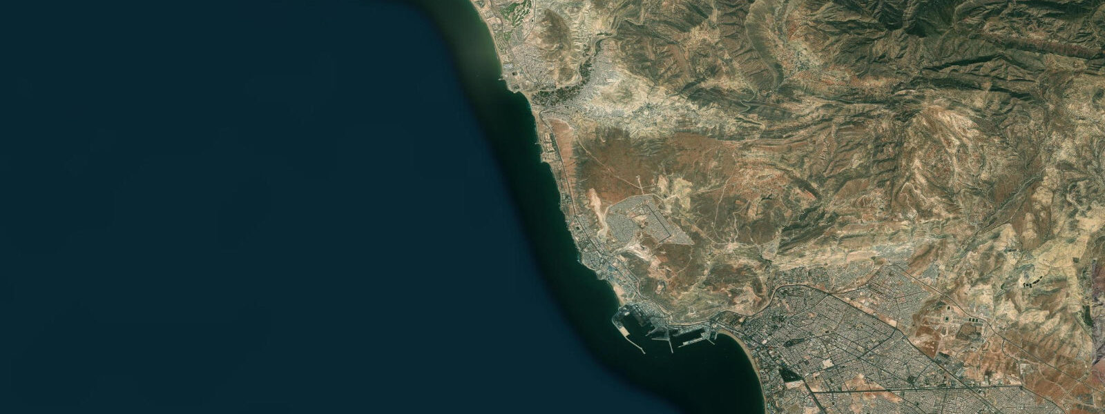
Agadir faces due west into the open Atlantic from a wide coastal plain at the foot of the Anti-Atlas mountains. The bay is large — the beach arc runs 9 kilometres from the port breakwater in the north to the Souss river mouth in the south — and the tidal cycle plays out across a gradual gradient that shifts the waterline 30 to 50 metres between high and low water. Mean tidal range is approximately 1.7 metres above Chart Datum; mean spring range reaches around 2.2 metres. The regime is semidiurnal: two highs and two lows per day, with roughly 6 hours between each.
The city that exists today was built after the earthquake of 29 February 1960, a magnitude 5.8 event that lasted approximately 15 seconds and killed around 15,000 people — roughly one third of the city's population at the time. The original medina, built on the coastal plain below the 16th-century kasbah on the hill, collapsed in two minutes. The kasbah walls on the ridge above the modern city survived; the ruins are preserved as a memorial and visible from the beach. The rebuilt Agadir is a modern low-rise city with broad avenues, the beach promenade at its centre, and the port at its northern end.
The beach at Agadir is wide, flat-graded, and sheltered from prevailing swell by the port breakwater to the northwest. This makes it calmer than the more exposed beaches north of the city — suitable for families and beginning swimmers, with consistent small-to-moderate shore break. Early morning low water in summer, when the sand is fully exposed and the offshore wind is light, is the best window for flat-water swimming and paddling. By late afternoon on most days, the Alizé — the northeast trade wind — picks up and pushes swell and chop onshore.
The port at the north end of the bay is an active commercial and fishing harbour. The day's catch — including sardines, sea bream, and squid — goes through the port fish market. A fish auction (lonja) runs in the late afternoon; the port-adjacent fish restaurants serve directly from the day's landing. Grilled sardines over charcoal, eaten at the quayside at dusk, is the most direct version of the port's offer.
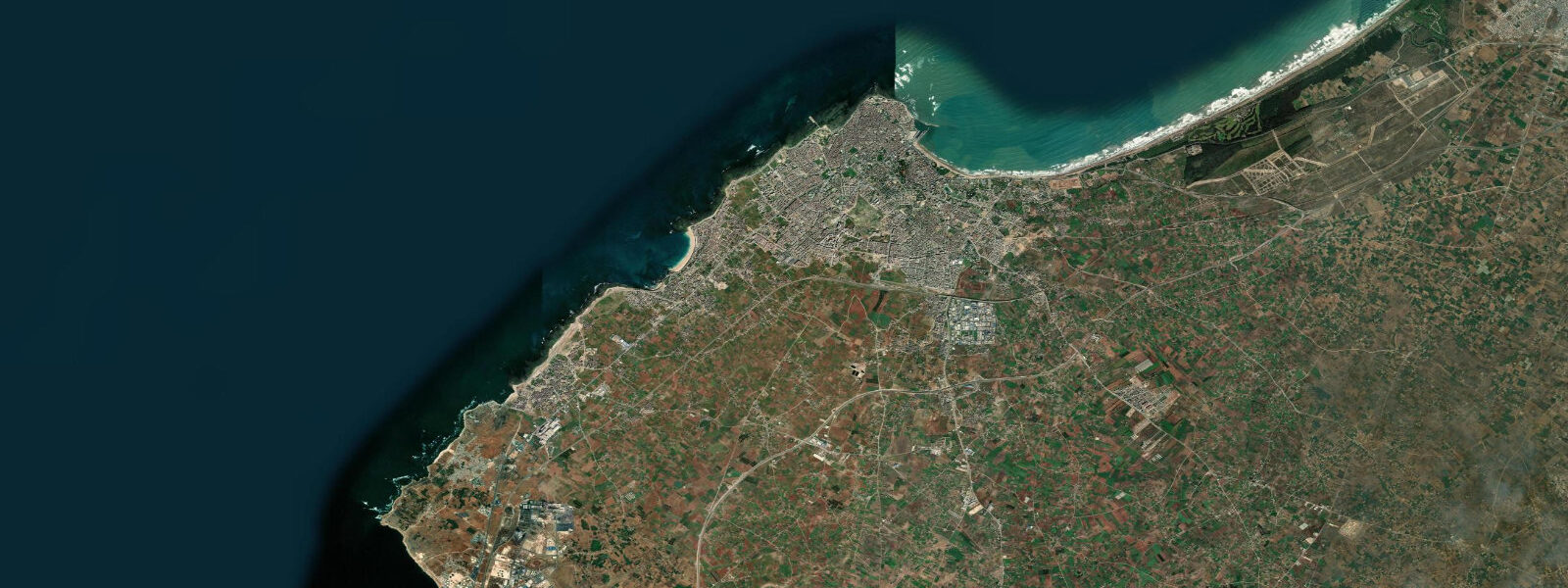
South of Agadir, across the Souss river estuary, is the Souss-Massa National Park. The intertidal mudflats and sandflats of the estuary fill and empty with the tide; the brackish wetlands attract flamingos and white storks year-round. The tidal influence extends 5 to 8 kilometres up the Souss River; at high tide the estuary is full and the mudflats are submerged; at low tide, they are exposed and available to wading birds. Access to the estuary reserve is from the south bank of the Souss, reached by road from Inezgane.
Agadir is the regional hub for day trips to Taghazout (20 km north, surf), the Souss valley palm groves, and the Tiznit silversmithing town (90 km south). The road north along the coast to Taghazout passes several smaller surf breaks — Boilers and Hash Point — that work on the same northwest swells but with less consistency than Anchor Point.
Tide predictions on this page come from Open-Meteo Marine, a gridded global ocean model. Accuracy is typically within plus or minus 45 minutes on timing and 0.2 to 0.3 metres on height. For authoritative official predictions, consult SHOMAR — Service Hydrographique et Océanographique de la Marine, Morocco's official hydrographic authority.
Tide questions about Agadir
Quick answers to the most common questions about tide times, range, and water access at Agadir.
What is the tidal range at Agadir and what does it mean for the beach?
Agadir has a semidiurnal mesotidal regime — two high and two low tides per day. Mean tidal range is approximately 1.7 metres above Chart Datum; spring range reaches around 2.2 metres. On the broad, gently graded beach, that range shifts the waterline by 30 to 50 metres horizontally. At mean low water springs the full width of the lower beach is exposed, creating the widest and flattest sand surface — best for walking, early swimming, and beach sport. At mean high water springs the sea comes up to the mid-beach zone. The tidal difference is less dramatic than the macrotidal Atlantic coasts of Europe, but noticeable and worth factoring into beach planning.
Why was Agadir rebuilt and what happened to the original city?
On 29 February 1960, a magnitude 5.8 earthquake struck at approximately 23:40 local time, centred just north of the city. The shaking lasted around 15 seconds. The original medina, built on the coastal plain below the kasbah hill, collapsed almost entirely; approximately 15,000 people died — roughly one third of Agadir's population at the time. The kasbah walls on the ridge above survived. The entire city was rebuilt from scratch on the same coastal plain over the following decade; the new Agadir is a modern, low-rise city with broad avenues. The kasbah ruins on the hill are preserved as a memorial and viewpoint; a replica medina (Ancien Talborjt) was constructed nearby for cultural reference.
What is the best time of day to swim at Agadir beach?
Early morning, particularly in summer, is the optimal window. The Alizé — a northeast trade wind that funnels down the Souss valley — picks up most afternoons between 14:00 and sunset, raising chop and pushing onshore swell. Before 11:00 the wind is typically light, the sea surface calm, and at low water the beach is at its widest. The water temperature at Agadir runs 18 to 20°C in spring, 20 to 22°C in summer, and drops to 16 to 18°C in winter — cooler than most beach resorts at comparable latitude because of the cold Canary Current upwelling along the Moroccan Atlantic coast.
What marine wildlife can be seen in the Souss estuary near Agadir?
The Souss River estuary, 5 kilometres south of central Agadir, is part of the Souss-Massa National Park and one of the more accessible wetland wildlife sites on the Moroccan Atlantic coast. Greater flamingos are present year-round on the intertidal mudflats and feed across the estuarine shallows at low tide. White storks nest on rooftops and pylons in the surrounding area. The estuary also supports black-winged stilt, avocet, spoonbill, and migrant waders during the spring and autumn shorebird passage. The best viewing window is low to mid-tide when the mudflats are exposed; access is from the south bank of the Souss via the road through Inezgane.
Are the tide predictions on this page official forecasts I can use for navigation or maritime planning?
No. Predictions on this page are generated by Open-Meteo Marine, a global gridded ocean model with a typical accuracy of plus or minus 45 minutes on timing and 0.2 to 0.3 metres on height. They are provided for general coastal planning — beach timing, tidal cycle awareness, wildlife visit planning — and are not a substitute for official tide tables. For navigation, vessel operations, port approach, or any safety-critical decision, use the official predictions from SHOMAR, the Service Hydrographique et Océanographique de la Marine, which is the authoritative tide prediction authority for Moroccan waters.
8-day tide table — Agadir
Heights relative to MSL. Predictions: Open-Meteo Marine (MeteoFrance SMOC, 0.08° grid) — heights relative to MSL (not chart datum / LAT). Model-derived.
| Day | Type | Time | Height |
|---|---|---|---|
| Sun 21 Jun | Low | 01:00 | -1.3m |
| High | 07:16 | 0.4m | |
| Low | 13:07 | -1.1m | |
| High | 19:32 | 0.6m | |
| Mon 22 Jun | Low | 02:00 | -1.1m |
| High | 08:15 | 0.4m | |
| Low | 14:10 | -0.9m | |
| High | 20:36 | 0.5m | |
| Tue 23 Jun | Low | 02:58 | -1.0m |
| High | 09:19 | 0.3m | |
| Low | 15:20 | -0.8m | |
| High | 21:40 | 0.4m | |
| Wed 24 Jun | Low | 03:55 | -0.9m |
| High | 10:20 | 0.4m | |
| Thu 25 Jun | Low | 04:54 | -1.0m |
| High | 11:17 | 0.4m | |
| Low | 17:26 | -1.0m | |
| High | 23:39 | 0.4m | |
| Fri 26 Jun | Low | 05:41 | -1.0m |
| High | 12:04 | 0.5m | |
| Low | 18:13 | -1.0m | |
| Sat 27 Jun | High | 00:27 | 0.4m |
| Low | 06:26 | -1.1m | |
| High | 12:49 | 0.6m | |
| Low | 18:58 | -1.1m | |
| Sun 28 Jun | High | 00:00 | 0.3m |