Savanna-la-Mar, Westmoreland tide times
Savanna-la-Mar, Westmoreland tide forecast — heights relative to MSL.
Today's tide times for Savanna-la-Mar, Westmoreland
Tide times at Savanna-la-Mar, Westmoreland on Friday, 19 June 2026: first low tide at 12:00am, first high tide at 06:50pm. Sunrise 10:37am, sunset 11:50pm.
Tide chart for Savanna-la-Mar, Westmoreland
24-hour cosine-interpolated curve around the present moment. Heights relative to MSL. Predictions: Predictions: Open-Meteo Marine (MeteoFrance SMOC, 0.08° grid).
Sun, moon and conditions on Fri 19 Jun
Snapshot at build time — refreshes daily. Sea state from Open-Meteo Marine.
Highs and lows next 7 days
Every predicted high and low for the next week, with the daily tidal coefficient (0–120; higher = bigger swing, > 95 means stronger currents).
Other spots nearby
The three closest curated TideTurtle locations to Savanna-la-Mar, Westmoreland, measured by great-circle distance.
Today's solunar windows
Solunar tradition: major periods are the ≈3h windows around moon transit and opposition; minor are ≈2h around moonrise and moonset. Pair with the local tide stage and wind for the best read.
Cycle dates near Savanna-la-Mar, Westmoreland
Next spring tide on Thu 25 Jun (range 0.3m). Last neap on Fri 19 Jun.
Spring tides cluster around new and full moons (biggest swings). Neap tides land on quarter moons (smallest swings). See the spring tide and neap tide glossary entries for the why.
About tides at Savanna-la-Mar, Westmoreland
A short guide to the coastline at Savanna-la-Mar, Westmoreland — geography, sea state, and what the tide is actually doing under your feet.
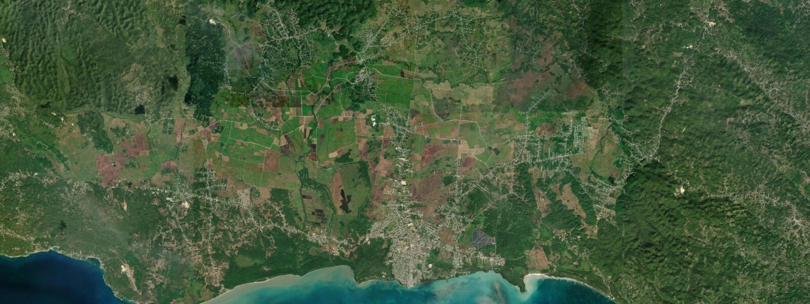
Savanna-la-Mar — Sav, to everyone who lives here — is the capital of Westmoreland parish and sits on Jamaica's south coast facing the open Caribbean. It is a working town, not a resort: the harbour handles local fishing boats, the market serves the agricultural hinterland, and the streets run on sugar-cane time as much as tourism time. For coastal visitors, Sav is the access point for the southwest Jamaica coast — the reef-protected fishing villages that run east toward the Great Morass and west toward Negril.
The tidal range is Caribbean microtidal: mean spring range 0.2–0.5 m. Jamaica's south coast faces the open Caribbean Sea, and the tidal signal is clean and predictable — two high waters and two low waters in each 24-hour period, with the semi-diurnal pattern that characterises this part of the basin. The range is small enough that casual beach visitors rarely notice it, but for the people who use the harbour and the coastal shallows daily, the 0.3–0.5 m change in water level matters.
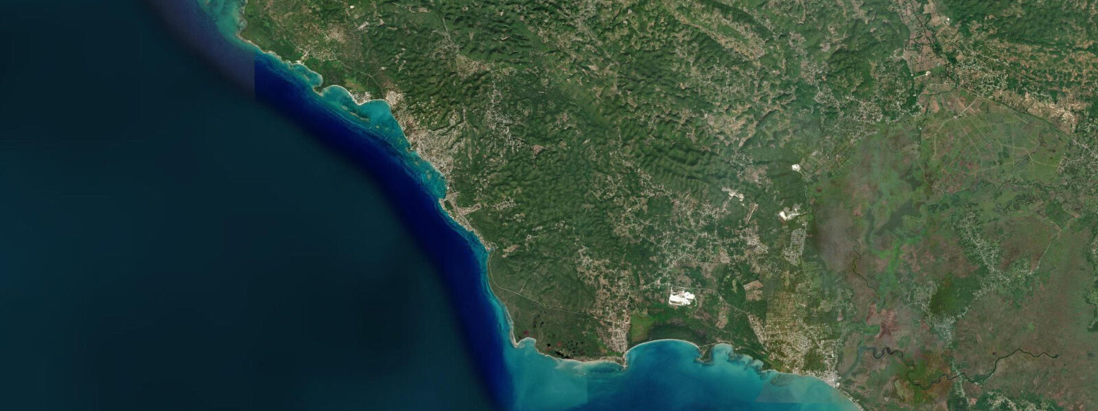
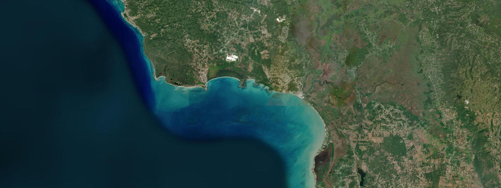
Savanna-la-Mar Harbour is the only significant port on Jamaica's southwest coast. It is a shallow, bar-constricted harbour — the entrance bar shallows to 1.5–2.0 m at low water on spring tides. Vessels with a draught greater than 1.2 m should enter on a rising tide, ideally within two hours of predicted high water, to maintain clearance over the bar. Local fishing pirogue operators know the bar intimately and cross it at all states of the tide in their shallow-draughted wooden boats; visiting yachtsmen without local knowledge should time entry carefully. The harbour interior is calmer than the anchorage off the bar; once inside, holding is reasonable in 3–4 m.
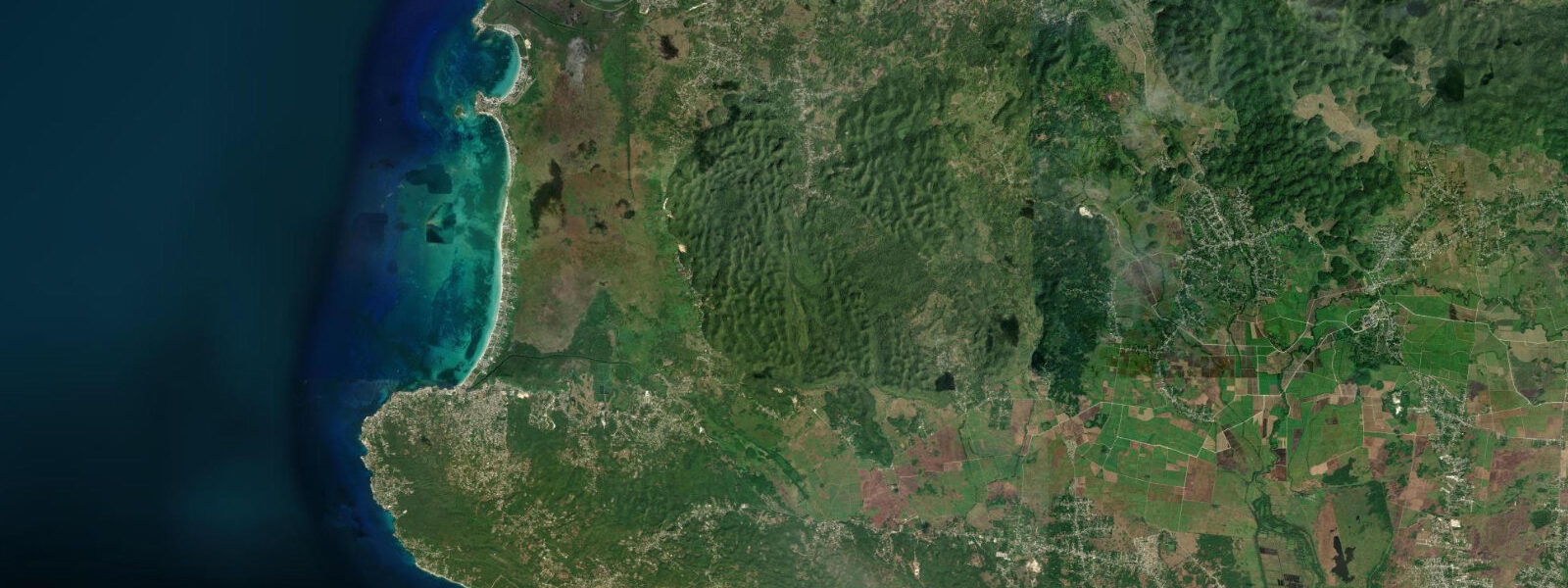
The Great Morass extends north and east of Sav — a 10 km² brackish wetland that begins at the edge of the town's development and runs inland. Mangrove tidal channels thread through the morass, carrying the tidal pulse up to 3 km from the coast. American crocodiles (Crocodylus acutus) are resident in the Great Morass. This species, distinct from the Cuban crocodile found to the northwest in the Ciénaga de Zapata, has a broader distribution across the Caribbean and is present in Jamaica's coastal wetlands wherever mangrove-fringed channels provide undisturbed habitat. Early morning — between 05:30 and 07:30 — is when crocodiles bask on channel banks before retreating to the water as temperatures rise. A guided canoe trip into the morass is the standard access method; pirogue operators in Sav sometimes offer these informally.
The south coast reef runs continuously west of Sav toward Negril, 25 km northwest. Between Savanna-la-Mar and Negril, the coast passes through a series of small reef-protected villages — Bluefields, Belmont, and Little Bay among them. The reef creates a lagoon of varying width along this stretch; fishing is done from the reef itself and from small boats anchored just outside the reef line. Shore anglers working the Sav harbour mole target snappers and jacks on the incoming tide, when the current funnels baitfish past the structure. The best fishing is typically on the hour either side of high water.
Frome Sugar Factory, 10 km north of Sav on the road to Montego Bay, is one of the largest sugar operations in the Caribbean — the agricultural context that explains the town's layout, its labour history, and the cane fields visible from any elevated point. The Frome labour uprising of 1938 was a significant event in Jamaican political history; the factory continues to operate. It is not a tourist facility but it is visible from the road and explains the scale of the agricultural infrastructure surrounding Sav.
For paddlers, the stretch of coast between Sav and Negril offers calm-water conditions inside the reef on most days. Stand-up paddleboard and kayak hire is more readily available in Negril; Sav itself has limited rental infrastructure. The reef-edge passage requires some reading of the break — find a channel before attempting to cross from lagoon to open sea.
For beach families, the reef-protected villages west of Sav — particularly Bluefields and Little Bay — offer calm, clear lagoon water without the crowds that concentrate in Negril. Transport is by shared taxi from Sav's central market area.
Tide data for Savanna-la-Mar, Westmoreland comes from the Open-Meteo Marine API, a gridded model product. Timing accuracy is ±45 minutes, height accuracy ±0.3 m — usable for trip planning, not for navigation.
Tide questions about Savanna-la-Mar, Westmoreland
Quick answers to the most common questions about tide times, range, and water access at Savanna-la-Mar, Westmoreland.
What is the depth over the Savanna-la-Mar Harbour bar at low tide?
The Savanna-la-Mar Harbour entrance bar shallows to 1.5–2.0 m at low water on spring tides, when the Caribbean's 0.2–0.5 m tidal range is at its maximum ebb. Vessels with draught greater than 1.2 m should plan entry within two hours of predicted high water, when the spring high adds up to 0.5 m over low-water depth and gives 2.0–2.5 m of clearance. Local fishing pirogues cross the bar at all states of tide in shallow-draughted wooden hulls; visiting recreational vessels should check the current tideturtle.com tide prediction and add a 0.3 m safety margin for model uncertainty. The bar shoaling is caused by longshore sediment transport; depths can shift seasonally.
Are there American crocodiles in the Great Morass near Savanna-la-Mar?
American crocodiles (Crocodylus acutus) are resident in the Great Morass, the brackish wetland immediately north and east of Savanna-la-Mar. The tidal channels of the morass provide suitable habitat — mangrove-fringed, relatively undisturbed, and connected to the coastal food chain by tidal exchange. Early morning observation between 05:30 and 07:30 gives the best sighting chances, when crocodiles bask on channel banks before the heat of the day drives them to the water. Guided canoe access into the morass channels is available informally through local pirogue operators in Sav; ask at the harbour. Do not approach animals on foot — American crocodiles in habitat with human presence can be unpredictable.
When is the best time to fish from the Savanna-la-Mar harbour mole?
Shore anglers at the Sav harbour mole target yellowtail snapper, lane snapper, and bar jack. The most productive window is the hour before and the hour after high water, when the tidal current funnels baitfish past the mole structure and brings predators in behind them. On a Caribbean spring tide, the high water rises 0.4–0.5 m above chart datum; use the tideturtle.com tide table to identify the peak and fish the run-up. Evening high tides are consistently better than morning highs for snapper at this location — the reduced light brings fish closer to the structure. Simple rigs with cut bait (sardine or squid) on a size 4/0 hook work reliably.
What is the reef like between Savanna-la-Mar and Negril?
The reef running along the south coast between Savanna-la-Mar and Negril Point (25 km northwest) is a fringing reef system set 200–600 m offshore. Inside the reef, the lagoon depth ranges from 1–3 m at high water and 0.5–2 m at low water — calm, clear water suitable for snorkelling and shallow kayaking. Outside the reef, the bottom drops away and ocean swells reach the reef crest from the south on trade-wind days. The villages of Bluefields and Little Bay along this stretch have beach access and reef channels used by local fishing boats. The reef at Bluefields Bay is considered one of the best snorkelling sites on the south coast, with coral coverage and fish density comparable to more visited north-coast sites.
How do I get from Savanna-la-Mar to the reef-protected villages on the southwest coast?
Shared taxis (route taxis) from the Savanna-la-Mar central market area run west toward Negril and northwest toward Montego Bay throughout the day. For the reef villages — Bluefields, Belmont, Little Bay — take the route toward Negril and ask to be dropped at the relevant village. Journey time is 20–35 minutes depending on the village and traffic. The taxis run from first light until around 19:00; after that, charter transport is necessary. Rental car hire in Sav is limited; the nearest reliable hire is in Negril or Montego Bay. For the Great Morass and harbour access, both are within walking distance of the town centre.
7-day tide table — Savanna-la-Mar, Westmoreland
Heights relative to MSL. Predictions: Open-Meteo Marine (MeteoFrance SMOC, 0.08° grid) — heights relative to MSL (not chart datum / LAT). Model-derived.
| Day | Type | Time | Height |
|---|---|---|---|
| Fri 19 Jun | Low | 00:00 | 0.4m |
| High | 18:50 | 0.5m | |
| Sat 20 Jun | Low | 00:00 | 0.4m |
| High | 06:45 | 0.6m | |
| Sun 21 Jun | Low | 14:10 | 0.4m |
| Mon 22 Jun | High | 22:00 | 0.6m |
| Tue 23 Jun | Low | 04:00 | 0.5m |
| High | 09:00 | 0.5m | |
| Low | 15:50 | 0.3m | |
| Wed 24 Jun | High | 10:00 | 0.5m |
| Low | 16:50 | 0.4m | |
| Thu 25 Jun | High | 00:00 | 0.7m |
| Low | 17:10 | 0.3m | |
| High | 23:00 | 0.6m |