Bari tide times
Bari tide forecast — heights relative to MSL.
Today's tide times for Bari
Tide times at Bari on Sunday, 21 June 2026: first low tide at 03:00. Sunrise 05:19, sunset 20:28.
Tide chart for Bari
24-hour cosine-interpolated curve around the present moment. Heights relative to MSL. Predictions: Predictions: Open-Meteo Marine (MeteoFrance SMOC, 0.08° grid).
Sun, moon and conditions on Sun 21 Jun
Snapshot at build time — refreshes daily. Sea state from Open-Meteo Marine.
Highs and lows next 7 days
Every predicted high and low for the next week, with the daily tidal coefficient (0–120; higher = bigger swing, > 95 means stronger currents).
Other spots nearby
The three closest curated TideTurtle locations to Bari, measured by great-circle distance.
Today's solunar windows
Solunar tradition: major periods are the ≈3h windows around moon transit and opposition; minor are ≈2h around moonrise and moonset. Pair with the local tide stage and wind for the best read.
About tides at Bari
A short guide to the coastline at Bari — geography, sea state, and what the tide is actually doing under your feet.
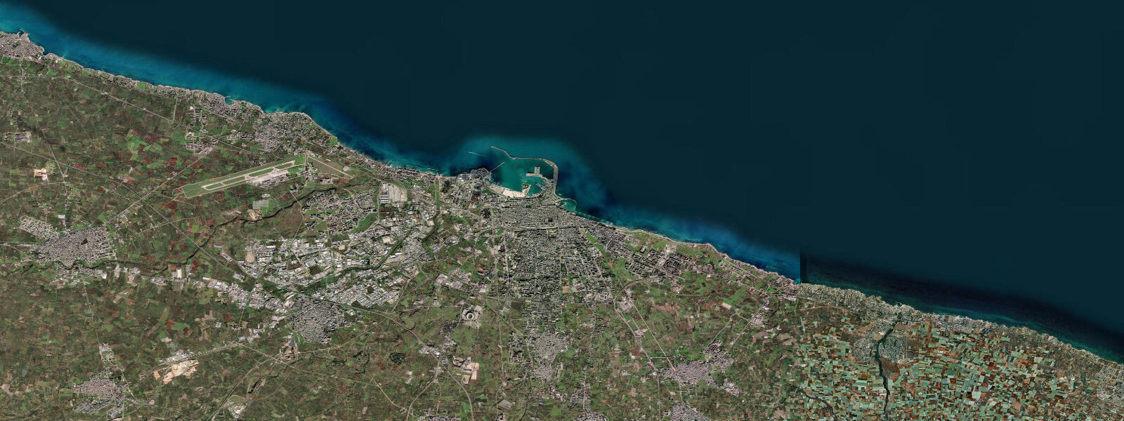
Bari is the capital of Puglia and the dominant port on the southern Adriatic, a city that has been a maritime gateway for more than two millennia. The old city, Bari Vecchia, occupies a compact limestone peninsula that juts directly into the Adriatic; its tight grid of whitewashed lanes is bounded on three sides by sea and on the fourth by the Castello Svevo, the Hohenstaufen castle begun by Roger II of Sicily in 1132 and substantially rebuilt by Frederick II in the 13th century. The Basilica di San Nicola, completed in 1197, was one of the primary embarkation-side pilgrim churches for Crusaders sailing to the Holy Land — Bari served as a major departure port during the First and Second Crusades.
Tidal range at Bari is approximately 0.3–0.4 m above Chart Datum, at the upper end of central-Adriatic values. The Adriatic is a semi-enclosed basin; tidal resonance within the basin amplifies the range slightly compared to the open Tyrrhenian — Bari's 0.35 m mean range is measurably larger than Livorno's 0.3 m, though still firmly in microtidal territory. The twice-daily (semidiurnal) tide is the dominant cycle, with a spring-neap modulation of roughly ±0.1 m either side of the mean.
For practical users: sea-kayakers launching from the old city foreshore will find current along the Bari Vecchia ramparts is negligible throughout the tidal cycle. Anglers on the outer breakwater (molo foraneo) fish primarily on baitfish and current driven by longshore drift and wind rather than tidal stream. The commercial ferry port, which operates routes to Albania, Montenegro, Croatia, and Greece, handles tidal state as irrelevant: berth depths are designed for roll-on/roll-off traffic independent of tide height.
The bora — a cold north-easterly katabatic wind — is the dominant sea-level anomaly driver on the Adriatic. A sustained bora can depress Bari sea level by 0.2–0.4 m (wind set-down on the west coast as water piles against the Albanian coast); southerly sirocco events do the opposite, raising levels by a comparable amount. ISPRA's Bari gauge on the Rete Mareografica Nazionale is the authoritative reference for storm surge events.
Open-Meteo Marine supplies the tide predictions shown (±45 min / ±0.2–0.3 m). ISPRA real-time and historical data are the appropriate source for any safety-critical sea-level assessment.
Tide questions about Bari
Quick answers to the most common questions about tide times, range, and water access at Bari.
What is the tidal range at Bari, and how does it compare to other Italian Adriatic ports?
Bari's mean tidal range is approximately 0.35 m above Chart Datum, in the range of 0.3–0.4 m depending on spring/neap phase. This is slightly larger than Tyrrhenian ports like Livorno (~0.3 m) due to modest tidal resonance within the semi-enclosed Adriatic basin. It remains firmly microtidal by global standards — North Sea spring ranges of 4–5 m dwarf it. Venice at the northern Adriatic head reaches 0.8–1.0 m mean range; Porto Tolle in the Po Delta around 0.7 m. Bari is mid-basin. Spring tides reach approximately 0.45 m; neaps around 0.25 m above Chart Datum.
How does the bora wind affect sea level in Bari, and is it more significant than the tide?
The bora is a cold, dry north-easterly katabatic wind that accelerates off the Dinaric Alps and across the Adriatic. A sustained bora (Force 6–8+) creates a wind set-down on the Italian (western) coast as surface water is pushed toward Albania, temporarily depressing Bari sea level by 0.2–0.4 m. Southerly sirocco wind does the opposite: set-up raises levels 0.2–0.4 m against the Italian shore. Both effects can equal or exceed the full astronomical tidal range. In practical terms, at Bari, wind-driven sea-level anomaly is often the larger variable. ISPRA Rete Mareografica Nazionale provides real-time monitoring.
Is Bari suitable for snorkelling or shore diving near the old city, and do tides create current?
The rocky foreshore around Bari Vecchia and along the coast south toward Torre a Mare has accessible snorkelling. Tidal currents are negligible — the 0.35 m range generates no meaningful stream along open coast or the old-city breakwaters. The dominant hazards for in-water activity are boat traffic in the ferry and commercial port approaches, long-period swell from south-easterly sirocco events, and reduced visibility after heavy rain (drainage from the city's combined sewer system can affect nearshore water clarity). Slack-water timing is not relevant here.
What is the historical significance of Bari's harbour for maritime activity?
Bari's natural harbour has been in commercial use since at least the Roman period. The city rose to particular prominence in the 11th–12th centuries under Norman and then Hohenstaufen rule as a strategic Adriatic port linking southern Italy to the eastern Mediterranean. The Basilica di San Nicola (1087–1197), built to house relics of Saint Nicholas brought from Myra, made Bari a major pilgrimage destination and embarkation point for Crusaders. The Castello Svevo on the harbour was Frederick II's administrative and defensive headquarters for the region. Today the port handles container traffic, Ro-Ro ferries to the Balkans and Greece, and cruise calls — the same geographic logic that made it a Crusader hub operates for modern Adriatic trade.
How accurate are the Bari tide predictions, and should I use them for ferry or vessel planning?
Tide predictions shown here are from Open-Meteo Marine, with typical accuracy of ±45 minutes on timing and ±0.2–0.3 m on height. For Bari's ferry operations to Albania, Montenegro, Croatia, and Greece, tidal state is not operationally relevant — the port is engineered for roll-on/roll-off traffic at all tide heights. For small-craft skippers planning coastal passages, the key variables are bora and sirocco wind forecasts rather than tidal height. For any safety-critical or commercial navigation decision, consult the Capitaneria di Porto di Bari's Notices to Mariners and ISPRA Rete Mareografica Nazionale real-time sea-level data. This page provides a planning orientation, not a certified hydrographic product.
8-day tide table — Bari
Heights relative to MSL. Predictions: Open-Meteo Marine (MeteoFrance SMOC, 0.08° grid) — heights relative to MSL (not chart datum / LAT). Model-derived.
| Day | Type | Time | Height |
|---|---|---|---|
| Sun 21 Jun | Low | 03:00 | -0.7m |
| Mon 22 Jun | — | ||
| Tue 23 Jun | — | ||
| Wed 24 Jun | — | ||
| Thu 25 Jun | High | 14:10 | -0.4m |
| Fri 26 Jun | — | ||
| Sat 27 Jun | Low | 08:00 | -0.6m |
| High | 15:10 | -0.3m | |
| Low | 21:50 | -0.6m | |
| Sun 28 Jun | High | 01:00 | -0.5m |