Reykjavík tide times
Reykjavík tide forecast — heights relative to MSL.
Today's tide times for Reykjavík
Tide times at Reykjavík on Sunday, 26 July 2026: first low tide at 00:00, first high tide at 03:58, second low tide at 10:03, second high tide at 16:21, third low tide at 22:45. Sunrise 04:15, sunset 22:50.
Tide chart for Reykjavík
24-hour cosine-interpolated curve around the present moment. Heights relative to MSL. Predictions: Predictions: Open-Meteo Marine (MeteoFrance SMOC, 0.08° grid).
Sun, moon and conditions on Sun 26 Jul
Snapshot at build time — refreshes daily. Sea state from Open-Meteo Marine.
Highs and lows next 7 days
Every predicted high and low for the next week, with the daily tidal coefficient (0–120; higher = bigger swing, > 95 means stronger currents).
Other spots nearby
The three closest curated TideTurtle locations to Reykjavík, measured by great-circle distance.


Today's solunar windows
Solunar tradition: major periods are the ≈3h windows around moon transit and opposition; minor are ≈2h around moonrise and moonset. Pair with the local tide stage and wind for the best read.
Cycle dates near Reykjavík
Next spring tide on Fri 31 Jul (range 3.4m). Last neap on Sun 26 Jul.
Spring tides cluster around new and full moons (biggest swings). Neap tides land on quarter moons (smallest swings). See the spring tide and neap tide glossary entries for the why.
About tides at Reykjavík
A short guide to the coastline at Reykjavík — geography, sea state, and what the tide is actually doing under your feet.
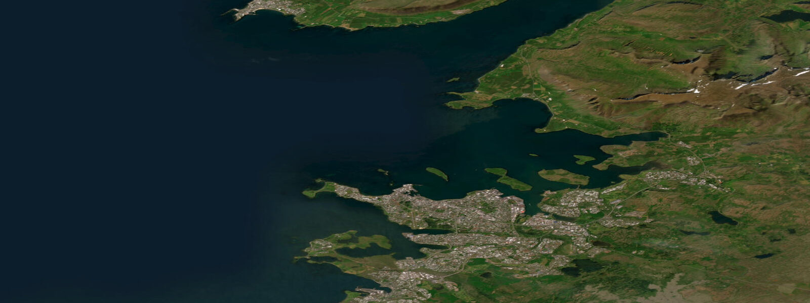
Reykjavík sits on the south-western corner of Iceland, fronting the long Faxaflói bay that opens west to the open North Atlantic, with the Reykjanes peninsula running south-west toward the Mid-Atlantic Ridge surface expression at the Bridge Between Continents and the geothermal coast running north toward Akranes. The Old Harbour at the foot of the city is the working fishing port and the launch point for whale-watching trips into the bay. The tide here is the open North Atlantic signal modulated by the shallow shelf around Iceland: cleanly semidiurnal in pattern, two highs and two lows of comparable size each day, twelve and a half hours apart.
5 on neaps. That is a substantial swing for such a high-latitude open-coast position, and the harbour fishing fleet at the Old Harbour reads it for boat-launch windows on the rising flood. The defining seasonal feature is photoperiod — the midnight sun in June produces 21-hour twilight days when the solunar fishing windows extend through what would be night anywhere else, and the December darkness around the winter solstice compresses solunar activity into a four-hour midday window.
Coastal Reykjavík sees the same swing year-round but the shore-walking and intertidal-photography windows shift dramatically with the seasons. The Atlantic puffin colonies at Lundey across the bay (an hour by boat in season), the geothermal beach at Nauthólsvík where hot-spring water mixes with the cold North Atlantic to produce an outdoor swimmable lagoon, the rocky intertidal at Grótta lighthouse on the western tip of the city, the long sand at Sandgerði on the Reykjanes peninsula, and the surf at Þorlákshöfn south of the peninsula all read the table for different windows. The lowest spring lows around new and full moons open the basalt-shelf intertidal at Grótta for hours either side, exposing kelp-forest margins and seabird-feeding zones.
Storm surge from North Atlantic depressions in winter can lift water levels well above predicted; the harmonic predictions on this site assume normal weather. Open-Meteo Marine drives the gridded predictions on this page; for authoritative Icelandic tide data, the Icelandic Coast Guard's Hydrographic Department (Sjómælingar Íslands) publishes the official tide tables and operates the Reykjavík reference gauge.
Tide questions about Reykjavík
Quick answers to the most common questions about tide times, range, and water access at Reykjavík.
When is the next high tide at Reykjavík?
The hero block shows the next high tide at the Reykjavík harbour gauge in local Iceland time (GMT, year-round, no DST). The 7-day table covers all the highs and lows. High water at Akranes north of the bay arrives a few minutes after the Reykjavík gauge; out on the Reykjanes peninsula at Sandgerði it leads by about ten minutes.
What's the typical tide range at Reykjavík?
Mean range at the harbour gauge is about 3.5 metres, climbing past 4.5 metres on the largest spring tides and dropping near 2.5 metres on neaps. The pattern is cleanly semidiurnal — two highs and two lows of comparable size each day, twelve and a half hours apart. That is a substantial swing for such a high-latitude open-coast position and reflects the shallow continental shelf around Iceland.
Where do these tide predictions come from?
Open-Meteo Marine, a gridded global ocean model. Useful for daily planning around the Old Harbour, the Grótta intertidal, the Nauthólsvík geothermal beach, and the Reykjanes peninsula. For authoritative Icelandic tide data, the Icelandic Coast Guard's Hydrographic Department (Sjómælingar Íslands) publishes the official tide tables and operates the Reykjavík reference gauge.
How does the midnight sun affect the solunar fishing windows?
The solunar window calculation uses moon-up and moon-down transits, plus sun position, to flag the major and minor activity periods of each day. At Reykjavík's latitude of 64°N the sun barely sets in June and barely rises in December, which compresses or extends the solunar overlap windows in seasonal patterns that anglers familiar with mid-latitude fishing rarely encounter. The site computes the windows from the local astronomy regardless of season; the table on this page flags them for each of the next 7 days.
Is this safe to use for navigation?
No. For piloting in or out of the Reykjavík Old Harbour, transiting Faxaflói, or working the Reykjanes peninsula coast use the Icelandic Coast Guard's Hydrographic Department authoritative tide tables, the Faxaflóahafnir pilotage guidance, and the Icelandic Maritime Administration notices to mariners. North Atlantic storm-surge events in winter can override the harmonic signal and the Reykjanes Ridge offshore is one of the more challenging stretches of the Mid-Atlantic for working vessels.
7-day tide table — Reykjavík
Heights relative to MSL. Predictions: Open-Meteo Marine (MeteoFrance SMOC, 0.08° grid) — heights relative to MSL (not chart datum / LAT). Model-derived.
| Day | Type | Time | Height |
|---|---|---|---|
| Sun 26 Jul | Low | 00:00 | -0.9m |
| High | 03:58 | 0.2m | |
| Low | 10:03 | -1.5m | |
| High | 16:21 | 0.6m | |
| Low | 22:45 | -1.5m | |
| Mon 27 Jul | High | 04:46 | 0.3m |
| Low | 10:50 | -1.7m | |
| High | 17:07 | 0.8m | |
| Low | 23:25 | -1.8m | |
| Tue 28 Jul | High | 17:44 | 0.9m |
| Wed 29 Jul | Low | 00:01 | -2.0m |
| High | 06:02 | 0.6m | |
| Low | 12:03 | -2.0m | |
| High | 18:18 | 1.0m | |
| Thu 30 Jul | Low | 00:35 | -2.1m |
| High | 06:37 | 0.7m | |
| Low | 12:38 | -2.2m | |
| High | 18:51 | 1.1m | |
| Fri 31 Jul | Low | 01:04 | -2.2m |
| High | 07:08 | 0.8m | |
| Low | 13:06 | -2.2m | |
| High | 19:23 | 1.1m | |
| Sat 01 Aug | Low | 01:35 | -2.3m |
| High | 07:42 | 0.8m | |
| Low | 13:39 | -2.3m | |
| High | 19:53 | 1.0m | |
| Low | 23:00 | -0.7m |