
Akranes, Capital Region tide times
Akranes, Capital Region tide forecast — heights relative to MSL.
Today's tide times for Akranes, Capital Region
Tide times at Akranes, Capital Region on Friday, 19 June 2026: first high tide at 00:00, first low tide at 03:02, second high tide at 09:13, second low tide at 15:12, third high tide at 21:35. Sunrise 02:51, sunset 00:07.
Tide chart for Akranes, Capital Region
24-hour cosine-interpolated curve around the present moment. Heights relative to MSL. Predictions: Predictions: Open-Meteo Marine (MeteoFrance SMOC, 0.08° grid).
Sun, moon and conditions on Fri 19 Jun
Snapshot at build time — refreshes daily. Sea state from Open-Meteo Marine.
Highs and lows next 7 days
Every predicted high and low for the next week, with the daily tidal coefficient (0–120; higher = bigger swing, > 95 means stronger currents).
Other spots nearby
The three closest curated TideTurtle locations to Akranes, Capital Region, measured by great-circle distance.

Today's solunar windows
Solunar tradition: major periods are the ≈3h windows around moon transit and opposition; minor are ≈2h around moonrise and moonset. Pair with the local tide stage and wind for the best read.
Cycle dates near Akranes, Capital Region
Last spring tide on Fri 19 Jun (range 3.4m). Next neap on Wed 24 Jun.
Spring tides cluster around new and full moons (biggest swings). Neap tides land on quarter moons (smallest swings). See the spring tide and neap tide glossary entries for the why.
About tides at Akranes, Capital Region
A short guide to the coastline at Akranes, Capital Region — geography, sea state, and what the tide is actually doing under your feet.
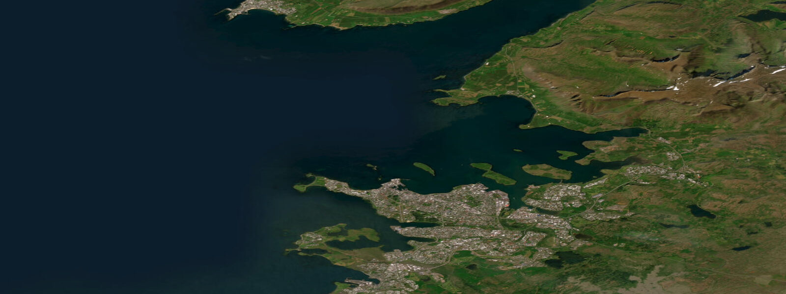
Akranes sits at the tip of the Akranes peninsula, projecting south into Faxaflói bay directly across from Reykjavík. The two towns are 10 kilometres apart across the water and linked by a ferry — the land route is 50 kilometres via the Hvalfjörður tunnel. Akrafjall, the flat-topped mountain that forms the backbone of the peninsula, rises to 643 metres immediately behind the town and is visible from Reykjavík on clear days. The combination of mountain, bay, and a working harbour with a cement factory makes Akranes one of the more characterful small industrial towns on the Icelandic coast.
Faxaflói's tidal range is driven by the bay's geometry. The bay opens southwest to the North Atlantic and has a funnel shape that amplifies the incoming tidal wave as it shoals. At Akranes, the mean spring range is 3.5 to 4.5 metres — toward the upper end of what is found in Icelandic waters, and significantly larger than the 2.5 to 3.0-metre range found in more exposed North Atlantic positions where the tidal wave is not concentrated by bay geometry. The tidal pattern is semidiurnal: two highs and two lows daily, with the highest tides occurring at new and full moon.
The harbour at Akranes has two operational roles: the Straumsvík cement factory (Iceland's largest, producing roughly 120,000 tonnes per year) loads bulk carriers from the factory quay, and those vessels are tide-constrained. A bulk carrier drawing 8 to 9 metres requires a tidal height of at least 10 metres above chart datum at the approach to berth safely; at Akranes the combination of the low water depth in the harbour approach and the tidal range means that loading windows are roughly four to six hours centred on high water on spring cycles. Vessel movements at the factory quay are therefore a visible indicator of tidal state — when the bulk carrier is alongside and loading, the tide is near high water.
For recreational users, the harbour entrance shallowest point becomes a constraint for smaller motorboats and yachts drawing more than 1.2 metres at the lowest two hours of spring tides. The marked channel is maintained but has limited dredging; local knowledge and a tidal prediction together are the working tools for timing entry.
The Akranes lighthouse, built in 1918 and one of the oldest active lighthouses in Iceland, stands on the headland at the very tip of the peninsula. The original lighthouse building and the newer concrete tower alongside it are both accessible; the older structure is now a local museum. The lighthouse point is the primary shore fishing location in the area. Cod and haddock are the main targets; saithe (coalfish) appear in numbers in autumn. Fishing from the lighthouse point works on the incoming tide — starting roughly two hours before low water and running through the first two hours of the flood. As the tide rises over the shallow gravel and kelp flats extending from the headland, bait fish concentrate at the edge of the advancing water, and cod follow from the deeper water offshore. On a spring flood at Akranes, that advancing edge moves at a perceptible pace across the flats — several metres per minute through the mid-flood phase.
The Reykjavík ferry departs from the harbour area (precise terminal location is at the inner quay) and runs a scheduled service. Crossing time is approximately 20 to 25 minutes; frequency varies by season. The service timing in the public schedule does not account for tidal state — the ferry uses an appropriately drafted vessel — but for private boat users crossing to or from Reykjavík, the tidal current in Faxaflói runs at 0.5 to 1.0 knots on neap tides and up to 1.5 knots at springs. A private motorboat crossing should account for the set and drift, particularly in the narrower water near the Akranes headland where the current accelerates around the peninsula tip.
The beach at Akranes (Leggjabrjótur) extends south from the town along the inner bay side of the peninsula. The beach is a dark volcanic sand, typical of Iceland, and faces east toward the Reykjavík shoreline across the bay. At low water on a spring tide the beach widens substantially, exposing a firm sand flat suitable for walking. The beach is less visited than Reykjavík beaches but has a similar quality: cold, clear, accessible, and with Esja and the Reykjavík waterfront visible across the water.
Akrafjall's summit plateau and the western ridge provide walking routes with views directly down onto Faxaflói and the harbour — an unusual perspective to watch tidal state from above, where the movement of water in and out of the bay is visible as a change in the colour and surface texture of the shallows off the lighthouse headland.
Tide data for Akranes, Capital Region comes from the Open-Meteo Marine API, a gridded model product. Timing accuracy is ±45 minutes, height accuracy ±0.3 m — usable for trip planning, not for navigation.
Tide questions about Akranes, Capital Region
Quick answers to the most common questions about tide times, range, and water access at Akranes, Capital Region.
What is the tidal range at Akranes and why is it larger than much of Iceland?
The mean spring range at Akranes is 3.5 to 4.5 metres, higher than many Icelandic locations because Faxaflói bay funnels the incoming North Atlantic tidal wave as it shoals toward the bay head. The funnel geometry amplifies tidal height; Reykjavík, directly across the bay, has a similar range for the same reason. Spring tides occur at new and full moon; neap tides, two weeks later, reduce the range to roughly 1.5 to 2.5 metres. The largest spring tides of the year coincide with the equinoxes in March and September.
When is the best time to fish from the Akranes lighthouse point?
The incoming flood tide, from roughly two hours before low water through the first two hours of the flood, is the productive window at the lighthouse headland. Cod and haddock follow bait fish over the shallowing gravel and kelp flats as the tide rises. On a spring flood the advance of the waterline across the flats is rapid and clearly visible from the headland. Saithe appear in good numbers in September and October. Morning and evening at low light supplement the tidal advantage — fish are less pressure-shy in lower light. Local spinners and bait rigs both work; cod take lures aggressively on the incoming stream.
Does the tide affect the Reykjavík ferry from Akranes?
The Reykjavík ferry operates on a scheduled service and uses a vessel with adequate draft for all tidal states, so the timetable does not vary with the tide. The crossing takes approximately 20 to 25 minutes. For users of private motorboats crossing Faxaflói, the tidal current runs at 0.5 to 1.0 knots on neap tides and up to 1.5 knots at springs; account for set and drift, particularly near the Akranes headland where the current accelerates around the peninsula tip. The land alternative is the Hvalfjörður tunnel route at 50 kilometres.
How does the tide affect the cement factory and harbour at Akranes?
The Straumsvík cement factory loads bulk carriers from the factory quay adjacent to the harbour. Vessels drawing 8 to 9 metres are tide-constrained and berth only during a four to six hour window centred on high water on spring cycles, when sufficient depth covers the harbour approach. Watching the bulk carrier's presence alongside — and the timing of its arrivals and departures — is a practical indicator of tidal state. Smaller recreational craft drawing over 1.2 metres should also time entry and exit to avoid the lowest two hours of spring tides in the harbour approach channel.
What is there to do at Akranes besides the lighthouse and fishing?
The old Akranes lighthouse (1918) houses a local history museum in the original building, with the newer operational tower alongside it. Akrafjall mountain behind the town has hiking routes to the summit plateau (643 m) with views down onto Faxaflói and the Reykjavík skyline. The dark volcanic sand beach (Leggjabrjótur) on the inner bay side of the peninsula is walkable and quiet; at low spring water it extends substantially with firm sand. Akranes is 50 kilometres from Reykjavík by road via the Hvalfjörður tunnel (the fjord itself is a separate scenic detour worth the additional time for its waterfall and whaling station history).
7-day tide table — Akranes, Capital Region
Heights relative to MSL. Predictions: Open-Meteo Marine (MeteoFrance SMOC, 0.08° grid) — heights relative to MSL (not chart datum / LAT). Model-derived.
| Day | Type | Time | Height |
|---|---|---|---|
| Fri 19 Jun | High | 00:00 | -0.5m |
| Low | 03:02 | -2.1m | |
| High | 09:13 | 0.9m | |
| Low | 15:12 | -2.0m | |
| High | 21:35 | 1.3m | |
| Sat 20 Jun | Low | 03:55 | -2.0m |
| High | 10:06 | 0.8m | |
| Low | 16:07 | -1.9m | |
| High | 22:27 | 0.9m | |
| Sun 21 Jun | Low | 04:50 | -1.9m |
| High | 11:00 | 0.5m | |
| Low | 17:07 | -1.8m | |
| High | 23:23 | 0.6m | |
| Mon 22 Jun | Low | 05:46 | -1.8m |
| High | 12:00 | 0.4m | |
| Low | 18:11 | -1.6m | |
| Tue 23 Jun | High | 00:22 | 0.4m |
| Low | 06:46 | -1.7m | |
| High | 13:02 | 0.3m | |
| Low | 19:20 | -1.4m | |
| Wed 24 Jun | High | 01:27 | 0.3m |
| Low | 07:46 | -1.5m | |
| High | 14:05 | 0.4m | |
| Thu 25 Jun | Low | 08:45 | -1.5m |
| High | 15:04 | 0.5m | |
| Low | 21:25 | -1.4m | |
| High | 23:00 | -1.1m |