Stokkseyri, Southern Region tide times
Stokkseyri, Southern Region tide forecast — heights relative to MSL.
Today's tide times for Stokkseyri, Southern Region
Tide times at Stokkseyri, Southern Region on Friday, 19 June 2026: first high tide at 00:00, first low tide at 02:28, second high tide at 20:56. Sunrise 02:59, sunset 23:52.
Tide chart for Stokkseyri, Southern Region
24-hour cosine-interpolated curve around the present moment. Heights relative to MSL. Predictions: Predictions: Open-Meteo Marine (MeteoFrance SMOC, 0.08° grid).
Sun, moon and conditions on Fri 19 Jun
Snapshot at build time — refreshes daily. Sea state from Open-Meteo Marine.
Highs and lows next 7 days
Every predicted high and low for the next week, with the daily tidal coefficient (0–120; higher = bigger swing, > 95 means stronger currents).
Other spots nearby
The three closest curated TideTurtle locations to Stokkseyri, Southern Region, measured by great-circle distance.

Today's solunar windows
Solunar tradition: major periods are the ≈3h windows around moon transit and opposition; minor are ≈2h around moonrise and moonset. Pair with the local tide stage and wind for the best read.
Cycle dates near Stokkseyri, Southern Region
Last spring tide on Fri 19 Jun (range 2.6m). Next neap on Wed 24 Jun.
Spring tides cluster around new and full moons (biggest swings). Neap tides land on quarter moons (smallest swings). See the spring tide and neap tide glossary entries for the why.
About tides at Stokkseyri, Southern Region
A short guide to the coastline at Stokkseyri, Southern Region — geography, sea state, and what the tide is actually doing under your feet.
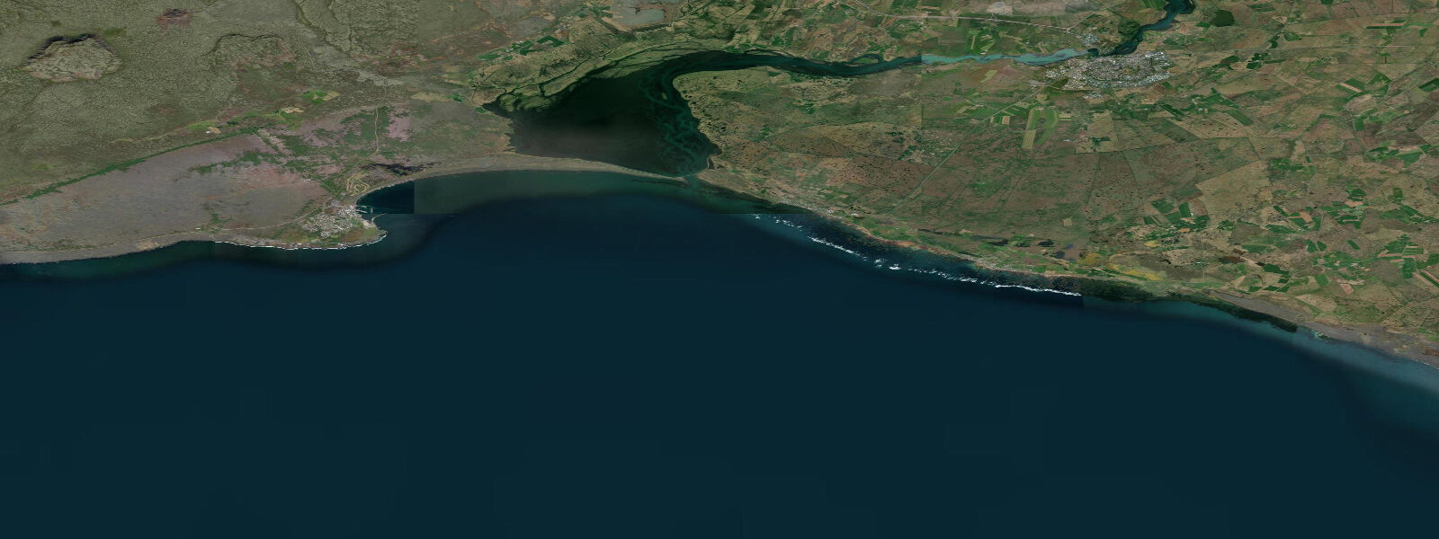
Stokkseyri sits on Iceland's south coast at the edge of the flat coastal plain that runs from the Þjórsá river delta east toward Vík. The village is small — under 500 people — with a working harbour, a row of painted wooden houses along the old fishing quarter, and a tidal foreshore that at low water extends 200 to 400 metres across exposed black lava sand flats. It is a fundamentally different coastal experience from the cliff-backed drama of Vík: wide, flat, open, and oriented around the agricultural and fishing economy of the southern lowlands.
The tidal range at Stokkseyri is among the largest on Iceland's south coast — mean range 3.0 to 4.0 metres, with spring tides at the upper end. The pattern is semidiurnal, meaning two high and two low waters per day of unequal height. At low water, the tidal flat exposed to the south and west of the harbour stretches far enough that the waterline disappears from view at ground level. The flats are composed of glacially derived black basalt sand, compacted enough in places to walk on but soft in others — rubber boots are practical if exploring the exposed flat rather than viewing from the harbour wall.
The Þjórsá and Ölfusá rivers are the defining geographic forces of this coastline. Both drain large portions of Iceland's interior highlands, picking up glacial meltwater from Hofsjökull, Langjökull, and Hengill in their respective catchments. The sediment these rivers carry — fine basaltic particles suspended in greyish glacial water — is continuously deposited at the coast, building and rebuilding the tidal flats. After heavy rain or warm-season snowmelt, the water discharging from the Ölfusá turns distinctly grey-green. The Ölfusá is the largest river in Iceland by volume; its mouth is visible from the western edge of the Stokkseyri coastline.
Lobster fishing is the economic foundation of Stokkseyri harbour. The species fished here is Nephrops norvegicus — Norway lobster, also marketed as langoustine or Dublin Bay prawn — which lives in burrows in the muddy seabed south of the tidal flat. The fleet works trap gear, and the timing of trap deployment and retrieval is coordinated loosely with tidal windows, though the boats operate in water deep enough that they are not tidal-constrained in the way inshore shellfish work often is. The harbour is working infrastructure: processing facilities, cold storage, and gear storage dominate the industrial side. The fish direct from the harbour cooperative is available through the associated restaurant, which has operated since the 1990s.
For birders, the low-water period is the productive time. The exposed tidal flat attracts redshanks, dunlins, ringed plovers, and oystercatchers systematically working the wet sand and puddle margins. In autumn (August–October), migrating waders pass through, and the flat provides stopover habitat. Whooper swans move through the agricultural fields behind the village in spring and autumn. The flatness of the terrain here, with long sight lines across the coastal plain, makes spotting straightforward.
Aurora viewing from Stokkseyri has a practical advantage: the flat horizon to the south and west means displays over the sea are unobstructed by terrain. The village has minimal streetlighting by European standards, and the coastal plain is dark. The aurora season runs effectively from late August to mid-April, with the peak activity correlating with equinox periods (September and March). Cloud cover is the primary constraint — the south coast is wetter and cloudier than the north, but clear spells occur. The tidal flat at night, with the aurora reflected in the shallow pools left by the retreating tide, is the specific visual payoff of the location.
The Langistigi alleyway runs through the oldest part of the village — a narrow passage between the traditional wooden fishing cottages that have been painted in bright colours and converted to artist studios and small galleries. The ghost museum at the western end of the village has occupied a prominent position in Stokkseyri's identity for years; it documents Icelandic folk ghost lore with a theatrical presentation. Neither is the reason to come to Stokkseyri specifically, but both repay an hour of walking time while waiting for the tide to drop and the flats to open.
The drive from Reykjavík is approximately 60 kilometres southeast on Route 38, around 45 minutes. Selfoss is the nearest large town (10 km east on Route 34), with full services. Stokkseyri itself is a day-trip destination from the capital rather than a multi-night base for most visitors.
Tide data for Stokkseyri, Southern Region comes from the Open-Meteo Marine API, a gridded model product. Timing accuracy is ±45 minutes, height accuracy ±0.3 m — usable for trip planning, not for navigation.
Tide questions about Stokkseyri, Southern Region
Quick answers to the most common questions about tide times, range, and water access at Stokkseyri, Southern Region.
What is the tidal range at Stokkseyri?
Stokkseyri has one of the largest tidal ranges on Iceland's south coast — a mean range of 3.0 to 4.0 metres, semidiurnal (two high and two low waters per day). At spring low water, the tidal flat to the south of the harbour extends 200 to 400 metres beyond the normal waterline. The flat is composed of glacially derived black basalt sand and is walkable in places with appropriate footwear. Predictions on this page come from the Open-Meteo Marine gridded model (±45 minutes, ±0.3 m accuracy).
What is the lobster fishing industry at Stokkseyri?
Stokkseyri harbour supports an active Nephrops norvegicus (Norway lobster / langoustine) fleet that has operated for decades. The boats work trap gear on the muddy seabed south of the tidal flat, deploying and retrieving traps on regular cycles. The harbour has processing and cold-storage facilities on the industrial side. Fresh langoustine from the cooperative is served at the associated harbour restaurant — the langoustine soup is the dish most associated with the village. The fishing industry is the economic base that the village tourism and cultural identity grew around.
What birds can I see on the Stokkseyri tidal flats?
At low water, the exposed flat attracts oystercatchers, redshanks, dunlins, and ringed plovers working the wet sand and tide-pool margins. Autumn migration (August–October) brings higher numbers and diversity of wading birds using the flat as stopover habitat. The wide flat horizon and minimal obstructions make the Stokkseyri foreshore one of the better casual birding spots on the south coast. Whooper swans are frequent on the agricultural plain behind the village during spring and autumn passage. The Ölfusá estuary to the west adds additional wetland habitat.
Is Stokkseyri a good spot for northern lights viewing?
Yes — the flat coastal horizon and low ambient light make Stokkseyri a practical aurora viewing location within easy reach of Reykjavík. The sea to the south and west provides an unobstructed low horizon, and at low tide the remaining shallow pools on the exposed flat can reflect active displays. The aurora season runs late August to mid-April; the equinox periods (September and March) tend to have elevated geomagnetic activity. Cloud cover is the main constraint on the south coast, which is wetter than Iceland's north. Check the cloud forecast alongside the aurora forecast before making the drive.
How do the Þjórsá and Ölfusá rivers affect the coast at Stokkseyri?
Both rivers drain large sections of Iceland's highland interior, carrying glacial meltwater and fine basaltic sediment to the south coast. The Ölfusá — Iceland's largest river by volume — discharges west of Stokkseyri; the Þjórsá discharges east. Their combined sediment load continuously builds and rebuilds the tidal flat. After periods of heavy rain or active snowmelt, river water reaching the coast turns distinctly grey-green from suspended glacial flour. River plumes are visible from the harbour wall during high-discharge periods. The flat itself is the geological product of thousands of years of this river-to-coast sediment transport.
7-day tide table — Stokkseyri, Southern Region
Heights relative to MSL. Predictions: Open-Meteo Marine (MeteoFrance SMOC, 0.08° grid) — heights relative to MSL (not chart datum / LAT). Model-derived.
| Day | Type | Time | Height |
|---|---|---|---|
| Fri 19 Jun | High | 00:00 | -0.8m |
| Low | 02:28 | -1.7m | |
| High | 20:56 | 1.0m | |
| Sat 20 Jun | Low | 03:19 | -1.6m |
| High | 09:23 | 0.5m | |
| Low | 15:27 | -1.6m | |
| High | 21:47 | 0.7m | |
| Sun 21 Jun | Low | 04:12 | -1.6m |
| High | 10:16 | 0.2m | |
| Low | 16:22 | -1.5m | |
| High | 22:43 | 0.3m | |
| Mon 22 Jun | Low | 05:07 | -1.5m |
| High | 11:18 | 0.1m | |
| Low | 17:26 | -1.4m | |
| High | 23:42 | 0.2m | |
| Tue 23 Jun | Low | 06:04 | -1.4m |
| High | 12:26 | 0.1m | |
| Low | 18:36 | -1.2m | |
| Wed 24 Jun | High | 00:46 | 0.1m |
| Low | 07:04 | -1.3m | |
| Thu 25 Jun | High | 01:52 | 0.1m |
| Low | 08:03 | -1.3m | |
| High | 14:36 | 0.3m | |
| Low | 20:47 | -1.2m | |
| High | 23:00 | -0.8m |