
Reykjavík tide times
Reykjavík tide forecast — heights relative to MSL.
Today's tide times for Reykjavík
Tide times at Reykjavík on Friday, 19 June 2026: first high tide at 00:00, first low tide at 03:00, second high tide at 09:12, second low tide at 15:10, third high tide at 21:34. Sunrise 02:55, sunset 00:02.
Tide chart for Reykjavík
24-hour cosine-interpolated curve around the present moment. Heights relative to MSL. Predictions: Predictions: Open-Meteo Marine (MeteoFrance SMOC, 0.08° grid).
Sun, moon and conditions on Fri 19 Jun
Snapshot at build time — refreshes daily. Sea state from Open-Meteo Marine.
Highs and lows next 7 days
Every predicted high and low for the next week, with the daily tidal coefficient (0–120; higher = bigger swing, > 95 means stronger currents).
Other spots nearby
The three closest curated TideTurtle locations to Reykjavík, measured by great-circle distance.

Today's solunar windows
Solunar tradition: major periods are the ≈3h windows around moon transit and opposition; minor are ≈2h around moonrise and moonset. Pair with the local tide stage and wind for the best read.
Cycle dates near Reykjavík
Last spring tide on Fri 19 Jun (range 3.4m). Next neap on Wed 24 Jun.
Spring tides cluster around new and full moons (biggest swings). Neap tides land on quarter moons (smallest swings). See the spring tide and neap tide glossary entries for the why.
About tides at Reykjavík
A short guide to the coastline at Reykjavík — geography, sea state, and what the tide is actually doing under your feet.
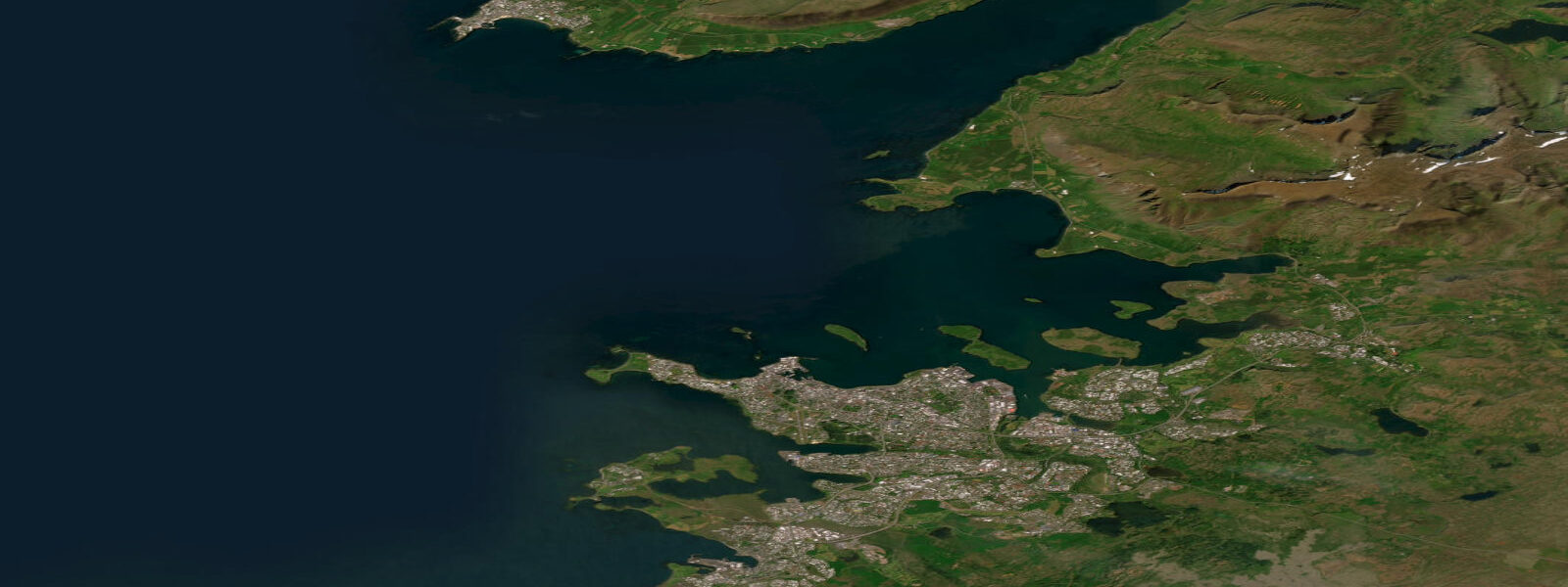
Reykjavík sits at 64 degrees north on the shore of Faxaflói bay, which opens west toward the North Atlantic. The city is the northernmost capital in the world and runs entirely on geothermal energy — the hot water that heats every building and fills the Laugardalslaug swimming complex flows from the volcanic geology 2 kilometres below the city. The old harbour (Grandi) and the new lighthouse district (Grótta) give two distinct waterfront experiences: the Grandi side is fish factories, whale-watching boats, and craft breweries converted from industrial units; Grótta is a tidal causeway walk to a lighthouse with views of Mount Esja across the bay.
Tidal range at Reykjavík is 3.0 to 4.0 metres at springs — the North Atlantic delivers substantial tidal movement into Faxaflói, and the bay geometry amplifies it. Tidal state matters concretely: the Grótta causeway is passable only around low tide; at high tide it disappears under the sea. The tidal flats exposed at low water in the inner bay attract large numbers of Arctic terns, oystercatchers, purple sandpipers, and eider ducks. Spring tides expose a much larger area than neap tides.
The sea temperature at Reykjavík reaches 11–12°C at its July–August peak. Wild swimming exists — Nauthólsvík geothermal beach, a small sheltered inlet south of the old airport, has a geothermal pipe warming a section of the bay to 15–20°C, with a changing facility and access to the cold sea alongside. It is a genuine local institution. The Sundhöll Reykjavíkur (indoor pool, 1937) and Laugardalslaug (outdoor, heated, with hot pots) are the mainstream aquatic infrastructure.
Whale watching operates from the old harbour year-round, with the highest success rates May through August when minke whales, humpbacks, and occasionally blue whales feed in Faxaflói. The departure point at Ægisgarður in the old harbour district has several competing operators; most trips run 3 hours and cover the feeding grounds 15–25 kilometres offshore. Puffin colonies on the Lundey and Akurey islands in the bay are visible from city shore in nesting season (May–August) and reachable by RIB boat in 15 minutes.
The Hallgrímskirkja church tower is the unambiguous orientation point for the city from the water — the stepped basalt-column architecture visible from the bay. The Harpa concert hall (Henning Larsen, 2011), on the harbourfront, serves as the cultural and event anchor. The domestic food supply runs through Kolaportið flea and fish market on weekends in the old harbour building; the restaurant scene clusters around Laugavegur and the food halls that have converted from the fishing industry infrastructure.
Predictions on this page come from Open-Meteo Marine, a gridded global ocean model. Accuracy is typically within plus or minus 45 minutes on timing and 0.2 to 0.3 metres on height — model-derived, not from a local gauge. For authoritative Icelandic tide data, consult the Icelandic Meteorological Office (Veðurstofa Íslands).
Tide questions about Reykjavík
Quick answers to the most common questions about tide times, range, and water access at Reykjavík.
What is the tidal range at Reykjavík?
Reykjavík has a spring tidal range of 3.0 to 4.0 metres — the North Atlantic delivers significant tidal movement into Faxaflói bay. The Grótta causeway is impassable at high tide (it submerges) and accessible only around low water; check the tide before walking it. Tidal flats exposed at low tide in the inner bay attract large numbers of seabirds and waders.
Can I swim in the sea at Reykjavík?
Yes, at Nauthólsvík geothermal beach — a sheltered inlet south of the old airport where a geothermal pipe warms a section of the bay to 15–20°C, making sea swimming genuinely comfortable even in summer when the open bay is 11°C. The facility has changing rooms and hot tubs adjacent to the cold sea. Open year-round; busiest in summer but used by regulars in winter. Admission is free.
When is whale watching best from Reykjavík?
May through August. Minke whales and humpbacks are most reliably seen in Faxaflói during this window when feeding activity peaks. Blue whales appear in some years. Orca (killer whale) sightings are occasional. Winter trips run and see fewer whales but more northern lights. Success rates vary by year and sea conditions; the harbour-based operators publish sighting records. Most trips are 3 hours; bring warm layers regardless of season.
What is Grótta and how do I get there?
Grótta is the westernmost point of Reykjavík, a tidal island connected to the city by a causeway that is passable for about 2–3 hours either side of low tide. The island has a lighthouse (automated, not open to visitors) and sweeping views across Faxaflói toward the Snæfellsnes glacier peninsula. It is reachable by bus (line 11 to the Grótta stop) or a 4-kilometre walk from Harpa concert hall along the shoreline path. Check tide times before setting out — stranding on the island at high tide is possible and requires a wait.
Is Iceland safe to visit in winter?
Yes, with preparation. Reykjavík has an urban infrastructure that functions normally through winter, and the northern lights are visible on dark, clear nights from October through March. The challenge is coastal and mountain weather — storms arrive quickly, road conditions change, and daylight in December is 4–5 hours. For coastal activities, the outer harbour whale-watching and the Grótta walk require checking forecasts. Dress in wool and waterproof layers; the wind is the significant variable, not the temperature alone.
7-day tide table — Reykjavík
Heights relative to MSL. Predictions: Open-Meteo Marine (MeteoFrance SMOC, 0.08° grid) — heights relative to MSL (not chart datum / LAT). Model-derived.
| Day | Type | Time | Height |
|---|---|---|---|
| Fri 19 Jun | High | 00:00 | -0.5m |
| Low | 03:00 | -2.1m | |
| High | 09:12 | 0.9m | |
| Low | 15:10 | -2.0m | |
| High | 21:34 | 1.3m | |
| Sat 20 Jun | Low | 03:53 | -2.0m |
| High | 10:04 | 0.8m | |
| Low | 16:06 | -1.8m | |
| High | 22:27 | 0.9m | |
| Sun 21 Jun | Low | 04:48 | -1.9m |
| High | 10:59 | 0.5m | |
| Low | 17:06 | -1.8m | |
| High | 23:22 | 0.6m | |
| Mon 22 Jun | Low | 05:45 | -1.8m |
| High | 11:58 | 0.4m | |
| Low | 18:10 | -1.6m | |
| Tue 23 Jun | High | 00:20 | 0.4m |
| Low | 06:44 | -1.7m | |
| High | 13:01 | 0.3m | |
| Low | 19:20 | -1.4m | |
| Wed 24 Jun | High | 01:27 | 0.3m |
| Low | 07:44 | -1.5m | |
| High | 14:03 | 0.4m | |
| Low | 20:25 | -1.4m | |
| Thu 25 Jun | High | 02:27 | 0.2m |
| Low | 08:43 | -1.5m | |
| High | 15:02 | 0.5m | |
| Low | 21:22 | -1.4m | |
| High | 23:00 | -1.1m |