Takoradi tide times
Takoradi tide forecast — heights relative to MSL.
Today's tide times for Takoradi
Tide times at Takoradi on Saturday, 4 July 2026: first low tide at 12:00am, first high tide at 06:24am, second low tide at 12:10pm, second high tide at 05:54pm. Sunrise 05:59am, sunset 06:23pm.
Tide chart for Takoradi
24-hour cosine-interpolated curve around the present moment. Heights relative to MSL. Predictions: Predictions: Open-Meteo Marine (MeteoFrance SMOC, 0.08° grid).
Sun, moon and conditions on Sat 04 Jul
Snapshot at build time — refreshes daily. Sea state from Open-Meteo Marine.
Highs and lows next 7 days
Every predicted high and low for the next week, with the daily tidal coefficient (0–120; higher = bigger swing, > 95 means stronger currents).
Other spots nearby
The three closest curated TideTurtle locations to Takoradi, measured by great-circle distance.
Today's solunar windows
Solunar tradition: major periods are the ≈3h windows around moon transit and opposition; minor are ≈2h around moonrise and moonset. Pair with the local tide stage and wind for the best read.
Cycle dates near Takoradi
Last spring tide on Sat 04 Jul (range 1.2m). Next spring tide on Fri 10 Jul (range 1.1m). Next neap on Wed 08 Jul.
Spring tides cluster around new and full moons (biggest swings). Neap tides land on quarter moons (smallest swings). See the spring tide and neap tide glossary entries for the why.
About tides at Takoradi
A short guide to the coastline at Takoradi — geography, sea state, and what the tide is actually doing under your feet.
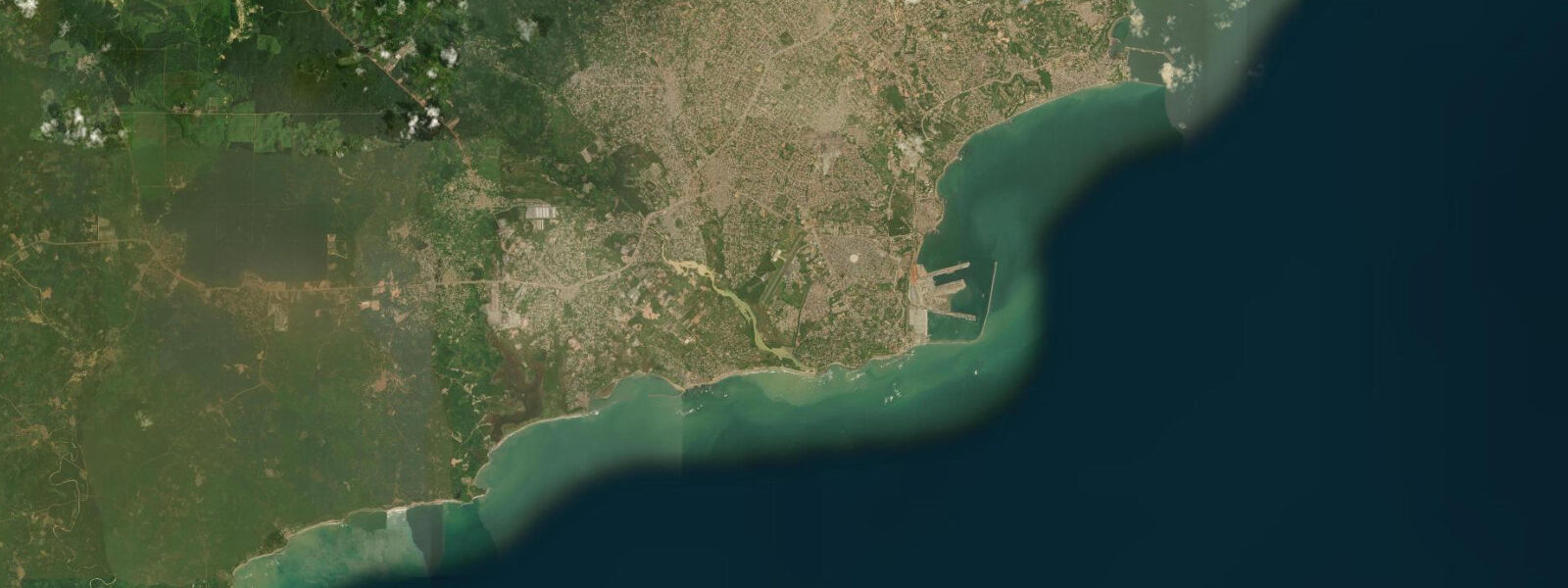
Takoradi is Ghana's main western port — a working industrial city that the discovery of offshore oil in the late 2000s transformed from a mid-size harbour town into the logistics backbone of the Jubilee, TEN, and Sankofa Gye Nyame oil fields. The city has grown fast around that infrastructure, and the coastal character that Takoradi once had — a compact fishing harbour, some colonial buildings, the natural shelter of the headland — has been complicated by a petroleum services sector that now dominates the foreshore east of the commercial port. None of which is a reason not to come here.
Takoradi is the hub for the entire Western Ghana coast: the road connections, the accommodation range, the markets, and the fuel-and-food supply chains that support the surf and dive operations at Busua, Dixcove, and Cape Three Points all run through this city. Understanding what Takoradi is — a busy port and industrial town, not a beach resort — sets expectations correctly and makes the actually good bits easier to find. The waterfront itself divides into the commercial port, which handles the oil-field supply vessels and freight, and the artisanal fishing harbour, which is a genuinely remarkable operation.
The fishing canoe fleet — entirely hand-powered wooden boats, many of them 12 to 15 metres long, painted in bright colours with Akan proverbs and football club insignia along the hull — launches before dawn most mornings and returns around mid-morning with catch from the overnight sets. The fish market running alongside the harbour from about 5 am is one of the most active in Ghana: snapper, grouper, yellowfin tuna, barracuda, and occasional dorado come in alongside the everyday reef species. The contrast between the artisanal canoes in the foreground and the jack-up rigs visible offshore on the horizon is one of those specifically Takoradi things.
Sekondi, immediately east of Takoradi and officially its twin city, has an older and more settled character. The colonial-era railway station — the western terminus of the original Gold Coast Railway built in the 1900s — is still partially operational. Fort Orange, a Dutch fort from the 1600s, stands near the Sekondi waterfront and is in better condition than most of the coastal forts in Ghana.
Sekondi beach, east of the harbour entrance, is where the outgoing tide exposes a broad sand flat that becomes the working territory of wading birds — whimbrel, sandpiper, egret — and of women collecting shellfish from the exposed rock pools. 2 metres. The semi-enclosed harbour attenuates wave energy considerably inside the port walls.
The open beaches east and west of the port see the direct Gulf of Guinea swell and have rips and shore break that should be treated with care. 3 m accuracy. For offshore fishing, boat charters targeting wahoo, dorado, and yellowfin tuna over the outer banks are available from the commercial harbour; the October–January cooler-water season is typically the most productive.
For surf and beach, the drive west to Busua (40 km, 40 minutes) is the standard move. For divers, Cape Three Points to the southwest has the deepest and most intact reef structures on this section of coast. Accommodation in Takoradi ranges from basic guesthouses near the lorry park to comfortable business hotels used by oil-industry contractors; the latter are significantly more comfortable for the money than anything available at the surf camps.
The twin-city is also the place to arrange Cape Three Points boat charters — the southernmost tip of Ghana, about 90 km southwest, has the deepest nearshore reef structures in the Western Region and is the most consistent location for offshore pelagic fishing on the Gold Coast.
Tide questions about Takoradi
Quick answers to the most common questions about tide times, range, and water access at Takoradi.
What coastal activities are available in Takoradi?
Takoradi itself is primarily a port city, so the coastal activities skew toward working-waterfront experiences rather than resort activities. The morning fish market at the harbour is one of the most lively in Ghana — arrive between 5 and 7 am for the full spectacle of the canoe fleet returning with overnight catch. Boat charters for offshore fishing (targeting wahoo, dorado, and yellowfin tuna over the offshore banks) are available from the commercial harbour; prices vary considerably, so negotiate through a reputable operator. Sekondi beach east of the port is the nearest accessible beach for a swim, best at mid to high tide. For surf and better beaches, the 40-km drive west to Busua is the standard move from Takoradi.
How do tides affect conditions at the Takoradi waterfront?
The harbour is semi-enclosed and heavily attenuated — tidal height changes are visible in the rise and fall against the quay walls, but wave energy is minimal inside the port. Spring tidal range runs 0.8–1.2 metres; neap range around 0.4–0.6 metres. The main tidal effect for practical purposes is the current in the harbour entrance channel, which runs with some force on the ebb. Fishing canoes working the harbour mouth time their exits to the flood tide. On Sekondi beach east of the harbour, the open-coast tidal pattern applies: exposed beach, rips at the rocky ends, safest swimming at mid to high tide. Tide predictions from Open-Meteo Marine carry ±45 min accuracy.
Is Takoradi a good base for exploring the Western Ghana coast?
Yes, it's the best base in the region. The road network is the most complete, the accommodation range is the widest, and the transport connections to Accra (bus), Kumasi (road), and Côte d'Ivoire (Elubo border) are all available from Takoradi. Busua Beach is 40 km west — around 40 minutes by road. Cape Three Points, the southernmost tip of Ghana and a good deep-sea fishing and diving charter destination, is about 90 km southwest. Ankasa Conservation Area for birding and wildlife is about 100 km northwest. Car rental is available in the city; for public transport, Takoradi lorry park has shared taxis to most Western Region destinations throughout the day.
What is the best time of year to visit Takoradi?
The Western Region has two rainy seasons: the main one from May to July, and a shorter one in October. The driest and most comfortable periods are August–September (a dry spell within the main rainy season, caused by the Ghanaian coastal climate pattern) and November–April. August and September also have the advantage of coinciding with the best surf season at Busua. For offshore fishing — wahoo, dorado, and tuna over the Ghanaian banks — the October–January period is generally the most productive, coinciding with the cooler upwelling season when pelagic species move toward the shelf edge. For birding in Ankasa, the post-rain months of October–December have the most active forest birdlife.
How do I reach Takoradi from Accra?
VIP Bus and other express services run Accra–Takoradi multiple times daily, departing from the main Accra bus terminals (Tudu, Kaneshie) and arriving at Takoradi. Journey time is 3.5–4.5 hours depending on traffic through Accra. The road (N1 / N8 via Cape Coast) is fully paved and well-maintained. Fares on express services are around 40–60 GHS one way; book a day ahead during holidays. Shared taxis and tro-tros run the same route but make more stops. For those driving, the Cape Coast–Elmina stretch adds worthwhile stops — Cape Coast Castle and Elmina Castle are the main Atlantic slave trade heritage sites in West Africa, both UNESCO-listed.
7-day tide table — Takoradi
Heights relative to MSL. Predictions: Open-Meteo Marine (MeteoFrance SMOC, 0.08° grid) — heights relative to MSL (not chart datum / LAT). Model-derived.
| Day | Type | Time | Height |
|---|---|---|---|
| Sat 04 Jul | Low | 00:00 | -0.7m |
| High | 06:24 | 0.5m | |
| Low | 12:10 | -0.4m | |
| High | 17:54 | 0.4m | |
| Sun 05 Jul | Low | 00:18 | -0.7m |
| High | 07:00 | 0.5m | |
| Low | 13:00 | -0.4m | |
| High | 18:42 | 0.3m | |
| Mon 06 Jul | Low | 01:00 | -0.6m |
| High | 07:40 | 0.5m | |
| Low | 13:50 | -0.4m | |
| High | 19:36 | 0.3m | |
| Tue 07 Jul | Low | 01:40 | -0.5m |
| High | 08:24 | 0.5m | |
| Low | 14:56 | -0.4m | |
| High | 20:42 | 0.2m | |
| Wed 08 Jul | Low | 02:36 | -0.5m |
| High | 09:18 | 0.5m | |
| Low | 16:03 | -0.5m | |
| High | 21:50 | 0.1m | |
| Thu 09 Jul | Low | 03:43 | -0.4m |
| High | 10:18 | 0.5m | |
| Low | 17:10 | -0.5m | |
| High | 23:10 | 0.1m | |
| Fri 10 Jul | Low | 04:56 | -0.4m |
| High | 11:20 | 0.4m | |
| Low | 18:18 | -0.7m | |
| High | 23:00 | 0.1m |