Ebeltoft tide times
Ebeltoft tide forecast — heights relative to MSL.
Today's tide times for Ebeltoft
Tide times at Ebeltoft on Sunday, 21 June 2026: first low tide at 02:00am, first high tide at 03:45am, second low tide at 09:40am, second high tide at 04:10pm. Sunrise 04:28am, sunset 10:08pm.
Tide chart for Ebeltoft
24-hour cosine-interpolated curve around the present moment. Heights relative to MSL. Predictions: Predictions: Open-Meteo Marine (MeteoFrance SMOC, 0.08° grid).
Sun, moon and conditions on Sun 21 Jun
Snapshot at build time — refreshes daily. Sea state from Open-Meteo Marine.
Highs and lows next 7 days
Every predicted high and low for the next week, with the daily tidal coefficient (0–120; higher = bigger swing, > 95 means stronger currents).
Other spots nearby
The three closest curated TideTurtle locations to Ebeltoft, measured by great-circle distance.
Today's solunar windows
Solunar tradition: major periods are the ≈3h windows around moon transit and opposition; minor are ≈2h around moonrise and moonset. Pair with the local tide stage and wind for the best read.
Cycle dates near Ebeltoft
Next spring tide on Wed 24 Jun (range 0.6m). Last neap on Sun 21 Jun. Next neap on Sat 27 Jun.
Spring tides cluster around new and full moons (biggest swings). Neap tides land on quarter moons (smallest swings). See the spring tide and neap tide glossary entries for the why.
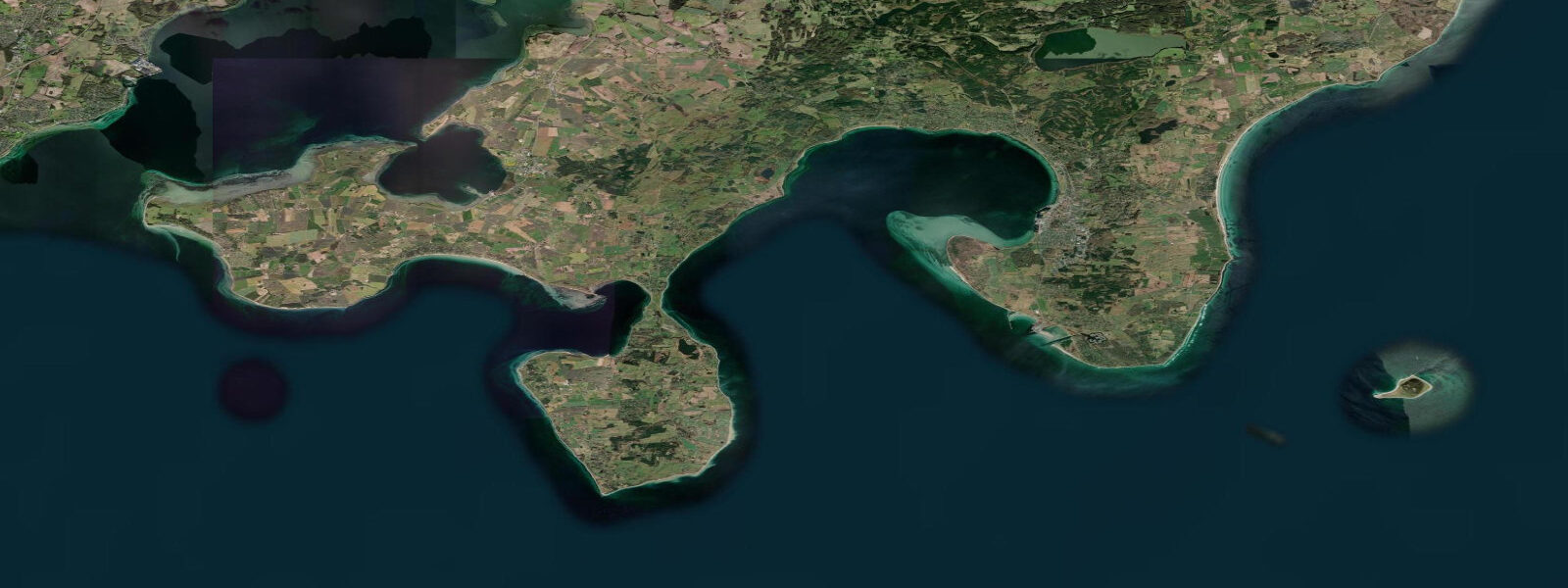
About tides at Ebeltoft
A short guide to the coastline at Ebeltoft — geography, sea state, and what the tide is actually doing under your feet.
3 m at this location. Two tidal cycles per day, but the signal is gentle: low water exposes a broad, firm sand-and-pebble foreshore in the Vig, and high water brings the sea back to the harbour walls with quiet efficiency. The frigate Jylland dominates the harbour's attention.
Launched in 1860, she is the oldest preserved screw-propelled warship in the world, and her hull — 71 m of iron-clad wooden construction — sits in a dry dock at the Ebeltoft Færgehavn museum. 3 m tidal excursion around her moorings is a reminder that this is a real sea, even if a calm one. The cobblestoned old town above the harbour is one of the best-preserved in Denmark, with half-timbered buildings dating to the 17th century.
Beach access is straightforward: the bay's sheltered aspect and shallow gradient make it ideal for swimming and kayaking at virtually any tide state. 4 m above prediction in persistent conditions. 3 m on height.
Tide questions about Ebeltoft
Quick answers to the most common questions about tide times, range, and water access at Ebeltoft.
What is the tidal range at Ebeltoft?
Approximately 0.3 m mean range at Ebeltoft, slightly less than the open Kattegat coast due to the sheltering effect of Ebeltoft Vig. The bay's semi-enclosed geometry dampens the already-modest tidal signal further. In practice, wind-driven water level changes often exceed the tidal range — a sustained northeast wind can add 0.2–0.4 m on top of the predicted high water.
What is the frigate Jylland and where is it located?
The frigate Jylland is the oldest preserved screw-propelled warship in the world. Launched in 1860, she is 71 m long and constructed of iron-reinforced wood. She is on permanent display in a dedicated dry dock at the Ebeltoft Færgehavn museum complex, right at the harbour. Admission is charged; the ship is accessible year-round, with seasonal variation in opening hours. The Kattegat tidal water lapping the dock outside is the same sea she served on during her active career.
Is swimming safe at Ebeltoft beach across the tidal cycle?
Yes. The sheltered bay, gentle gradient, and 0.3 m tidal range make Ebeltoft beach accessible and safe for swimming at virtually any tide state. The foreshore is widest at low water but the difference is subtle. Main safety consideration is wind chop from the northeast, which can build surprisingly quickly even in the protected bay. Check DMI's coastal forecast for wind before entering the water.
How long is the ferry crossing from Ebeltoft?
Ebeltoft is served by the Mols-Linien high-speed ferry to Odden (Zealand), with crossings taking approximately 65–75 minutes depending on service type. Ferry schedules run multiple times daily. Tidal state has minimal impact on the crossing itself given the modest range, but wind over the Kattegat can affect departure timing and sea conditions — check the operator's live status alongside DMI's marine forecast for your travel day.
Are tide predictions for Ebeltoft guaranteed to be accurate?
No prediction is guaranteed. Data on this page comes from Open-Meteo Marine modelling (typical accuracy ±45 minutes on timing, ±0.2–0.3 m on height) and is intended as planning guidance only. DMI (Danmarks Meteorologiske Institut) is the authoritative source for Danish coastal waters. Consult DMI's forecasts before any activity where tidal state affects safety. This site does not accept responsibility for decisions made based on these predictions.
8-day tide table — Ebeltoft
Heights relative to MSL. Predictions: Open-Meteo Marine (MeteoFrance SMOC, 0.08° grid) — heights relative to MSL (not chart datum / LAT). Model-derived.
| Day | Type | Time | Height |
|---|---|---|---|
| Sun 21 Jun | Low | 02:00 | -0.2m |
| High | 03:45 | -0.1m | |
| Low | 09:40 | -0.5m | |
| High | 16:10 | -0.1m | |
| Mon 22 Jun | Low | 10:40 | -0.7m |
| High | 17:07 | -0.2m | |
| Low | 23:18 | -0.5m | |
| Tue 23 Jun | High | 05:36 | -0.1m |
| Low | 11:55 | -0.6m | |
| High | 18:07 | -0.1m | |
| Wed 24 Jun | Low | 00:06 | -0.4m |
| High | 06:10 | -0.0m | |
| Low | 13:07 | -0.6m | |
| High | 19:15 | -0.1m | |
| Thu 25 Jun | Low | 01:06 | -0.4m |
| High | 07:16 | 0.0m | |
| Low | 14:10 | -0.4m | |
| High | 19:47 | -0.1m | |
| Fri 26 Jun | Low | 02:12 | -0.4m |
| High | 08:07 | -0.1m | |
| Low | 14:54 | -0.5m | |
| High | 20:47 | -0.2m | |
| Sat 27 Jun | Low | 03:18 | -0.5m |
| High | 09:00 | -0.2m | |
| Low | 15:42 | -0.5m | |
| High | 21:21 | -0.2m | |
| Sun 28 Jun | Low | 01:00 | -0.4m |