Chivirico tide times
Chivirico tide forecast — heights relative to MSL.
Today's tide times for Chivirico
Tide times at Chivirico on Sunday, 21 June 2026: first low tide at 10:00pm. Sunrise 06:29am, sunset 07:49pm.
Tide chart for Chivirico
24-hour cosine-interpolated curve around the present moment. Heights relative to MSL. Predictions: Predictions: Open-Meteo Marine (MeteoFrance SMOC, 0.08° grid).
Sun, moon and conditions on Sun 21 Jun
Snapshot at build time — refreshes daily. Sea state from Open-Meteo Marine.
Highs and lows next 7 days
Every predicted high and low for the next week, with the daily tidal coefficient (0–120; higher = bigger swing, > 95 means stronger currents).
Other spots nearby
The three closest curated TideTurtle locations to Chivirico, measured by great-circle distance.
Today's solunar windows
Solunar tradition: major periods are the ≈3h windows around moon transit and opposition; minor are ≈2h around moonrise and moonset. Pair with the local tide stage and wind for the best read.
About tides at Chivirico
A short guide to the coastline at Chivirico — geography, sea state, and what the tide is actually doing under your feet.
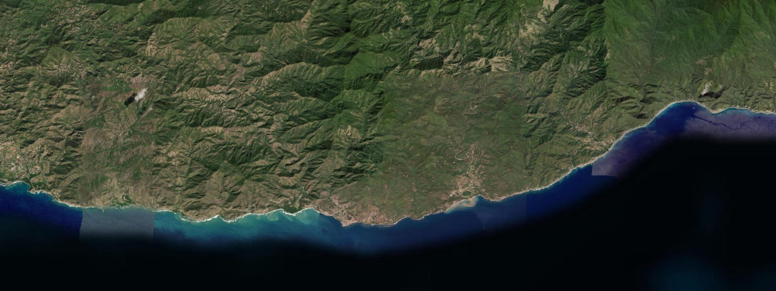
Chivirico sits roughly 100 km west of Santiago de Cuba on one of the most dramatically compressed coastlines in the Caribbean: the Sierra Maestra drops almost directly into the sea here, with the mountain ridge rising above 1,000 m within a few kilometres of the shoreline and the road from Santiago clinging to ledges cut into the cliff face above the water. Pico Turquino, Cuba's highest peak at 1,974 m, stands roughly 30 km east along the ridge and is visible on clear days from the beach at Chivirico as a serrated summit above the lower coastal hills.
The village itself is small — a few hundred residents, a base for the adjacent Villa Chivirico beach resort, and the last significant settlement before the coast road deteriorates west toward Marea del Portillo. The beach runs east of the village, roughly 800 m of dark-sand and mixed-pebble shoreline backed by coconut palms, facing south across the open Caribbean toward Jamaica 180 km away. The orientation means it receives whatever swell the Caribbean generates from the south and southeast, with no significant coastal shelter except for the headlands at each end of the beach arc.
The tidal regime is mixed semidiurnal Caribbean microtidal. Mean spring range on this open south coast runs approximately 30 to 50 cm, with two unequal highs and two unequal lows each day. The diurnal inequality is typical of the mixed Caribbean pattern: one of the daily highs is consistently the larger, one of the lows consistently the deeper. On a neap tide the swing compresses toward 15 to 25 cm. The actual water level at any moment is more strongly influenced by the direction and strength of Caribbean wind and by the passage of weather systems through the Windward Passage — between Cuba and Haiti — than by the astronomical tide. The Instituto Cubano de Hidrografía (GEOCUBA) is the authoritative tidal reference for Cuban waters; predictions on this page come from Open-Meteo Marine, a gridded global ocean model, accurate to approximately ±45 min and ±0.2–0.3 m.
For anglers, Chivirico is known for small-boat fishing in the waters immediately offshore. The continental shelf narrows sharply on this coast — the water deepens quickly beyond the near-shore zone — and snapper, grouper, and amberjack are the main targets. Pangas and small fibra boats launch from the beach or the small harbour structure at the village; the incoming tide in the pre-dawn window is the traditional session for the bottom-fishing grounds on the shelf edge. Shore fishing from the rocky points at each end of the beach produces jack crevalle and the occasional barracuda on the incoming tide.
The Carretera del Sur — the south coast road connecting Santiago to the remote western cape — runs above the beach and the clifftop for much of this section. At several points between Chivirico and the resort, the road is carved directly into the cliff face with the sea visible directly below the guard rail, giving the drive one of the most striking coastal perspectives in Cuba. Landslide risk during heavy rain events occasionally closes sections of this road; the rainy season runs May through October, with tropical disturbance activity peaking August through October.
For swimming and beach use, the beach at Chivirico is generally safe in calm weather. The slope is moderate, the water deepens gradually, and the south-facing orientation means the dominant swell arrives from south and southeast. Caribbean swells from Saharan low pressure systems or the early stages of tropical development in the Atlantic can produce a heavier south swell without warning; checking the Instituto de Meteorología de Cuba's marine forecast before any open-water activity is the standard practice.
Beach-walkers and photographers benefit from the Sierra Maestra backdrop — the mountain ridge visible behind the beach is a compositional element found nowhere else on the Cuban coast. Morning light from the east illuminates the mountain face before it reaches the beach; afternoon light from the west catches the water and the palm fringe. The dramatic cliffs of the coast road above the village are best photographed from the beach itself in early morning.
Predictions on this page come from Open-Meteo Marine. Accuracy is typically ±45 min and ±0.2–0.3 m. GEOCUBA harmonic predictions are the authoritative source for any navigation in these waters.
Tide questions about Chivirico
Quick answers to the most common questions about tide times, range, and water access at Chivirico.
When is the next high tide at Chivirico?
The hero block at the top of this page shows the next predicted high at Chivirico in local Cuba Standard Time (CST/CDT, UTC-5/UTC-4 with daylight saving in effect May through October). The astronomical range on this open south coast is roughly 30 to 50 cm on spring tides — small but larger than the further-dampened figure inside Santiago de Cuba harbour, since this coast is exposed to the open Caribbean without a restricted bay entrance. Wind and the passage of weather systems through the Windward Passage produce water-level changes that regularly match or exceed the astronomical tide. The Instituto Cubano de Hidrografía (GEOCUBA) publishes the authoritative harmonic predictions for Cuban ports.
How dramatic is the Sierra Maestra coastline at Chivirico?
Chivirico sits at one of the most compressed mountain-to-sea transitions in the Caribbean. The Sierra Maestra ridge rises above 1,000 m elevation within a few kilometres of the shoreline, and in some sections the road from Santiago de Cuba is literally carved into the cliff face above the water. Pico Turquino at 1,974 m, Cuba's highest point, stands roughly 30 km east along the ridge and is visible from the beach on clear days. The combination of steep forested mountains dropping directly to a dark-sand Caribbean beach with no flat coastal plain between them is geologically unusual on the island, where most of the north and west coasts have broad, low-lying terrain behind the beach.
What fish can you catch from Chivirico?
Small-boat fishing from Chivirico targets snapper, grouper, and amberjack on the shallow shelf grounds offshore, where the water deepens quickly from the beach to the shelf edge. Shore casting from the rocky points at each end of the beach produces jack crevalle and barracuda on the incoming tide; the early morning window before sunrise is consistently the most productive for shore anglers on this coast. The angler tradition that uses moon transits (solunar approach) rates sessions around new and full moon highest, when tidal exchange is at its maximum and the shelf-edge current is strongest. Local panga operators in the village take anglers out on half-day trips; the outgoing arrangement is informal and best negotiated on arrival.
When is the road from Santiago to Chivirico passable?
The Carretera del Sur connecting Santiago de Cuba to Chivirico and the remote western cape is paved but narrow, with sections carved into cliff faces above the sea. In dry conditions — November through April — the road is reliable, though slow. In the rainy season from May through October, heavy rainfall can trigger landslides that close short sections for hours to days; the September and October tropical-disturbance peak is the highest-risk period. Cuban national media and the local MINTUR (Ministerio de Turismo) offices in Santiago are the best sources for current road conditions. The drive from Santiago city to Chivirico takes approximately two hours in normal conditions.
Is this safe to use for navigation?
No. The south coast of Cuba in Santiago de Cuba province is a remote, steep coast with limited safe anchorage and significant weather exposure from the Windward Passage. For any vessel operation in these waters, use GEOCUBA's official Cuban charts and harmonic predictions, the relevant Avisos a los Navegantes, and the marine forecast issued by the Instituto de Meteorología de Cuba. The Open-Meteo Marine gridded predictions on this page are not gauge-calibrated harmonic data and do not replace authoritative sources for navigation.
7-day tide table — Chivirico
Heights relative to MSL. Predictions: Open-Meteo Marine (MeteoFrance SMOC, 0.08° grid) — heights relative to MSL (not chart datum / LAT). Model-derived.
| Day | Type | Time | Height |
|---|---|---|---|
| Sun 21 Jun | Low | 22:00 | 0.3m |
| Mon 22 Jun | High | 17:15 | 0.4m |
| Tue 23 Jun | — | ||
| Wed 24 Jun | Low | 11:45 | 0.2m |
| Thu 25 Jun | High | 19:50 | 0.5m |
| Fri 26 Jun | Low | 13:00 | 0.2m |
| Sat 27 Jun | High | 19:00 | 0.4m |