Santiago de Cuba tide times
Santiago de Cuba tide forecast — heights relative to MSL.
Today's tide times for Santiago de Cuba
Tide times at Santiago de Cuba on Sunday, 21 June 2026: first low tide at 09:10am, first high tide at 04:10pm, second low tide at 10:00pm. Sunrise 06:25am, sunset 07:45pm.
Tide chart for Santiago de Cuba
24-hour cosine-interpolated curve around the present moment. Heights relative to MSL. Predictions: Predictions: Open-Meteo Marine (MeteoFrance SMOC, 0.08° grid).
Sun, moon and conditions on Sun 21 Jun
Snapshot at build time — refreshes daily. Sea state from Open-Meteo Marine.
Highs and lows next 7 days
Every predicted high and low for the next week, with the daily tidal coefficient (0–120; higher = bigger swing, > 95 means stronger currents).
Other spots nearby
The three closest curated TideTurtle locations to Santiago de Cuba, measured by great-circle distance.
Today's solunar windows
Solunar tradition: major periods are the ≈3h windows around moon transit and opposition; minor are ≈2h around moonrise and moonset. Pair with the local tide stage and wind for the best read.
Cycle dates near Santiago de Cuba
Next spring tide on Tue 23 Jun (range 0.3m). Next neap on Sun 21 Jun.
Spring tides cluster around new and full moons (biggest swings). Neap tides land on quarter moons (smallest swings). See the spring tide and neap tide glossary entries for the why.
About tides at Santiago de Cuba
A short guide to the coastline at Santiago de Cuba — geography, sea state, and what the tide is actually doing under your feet.
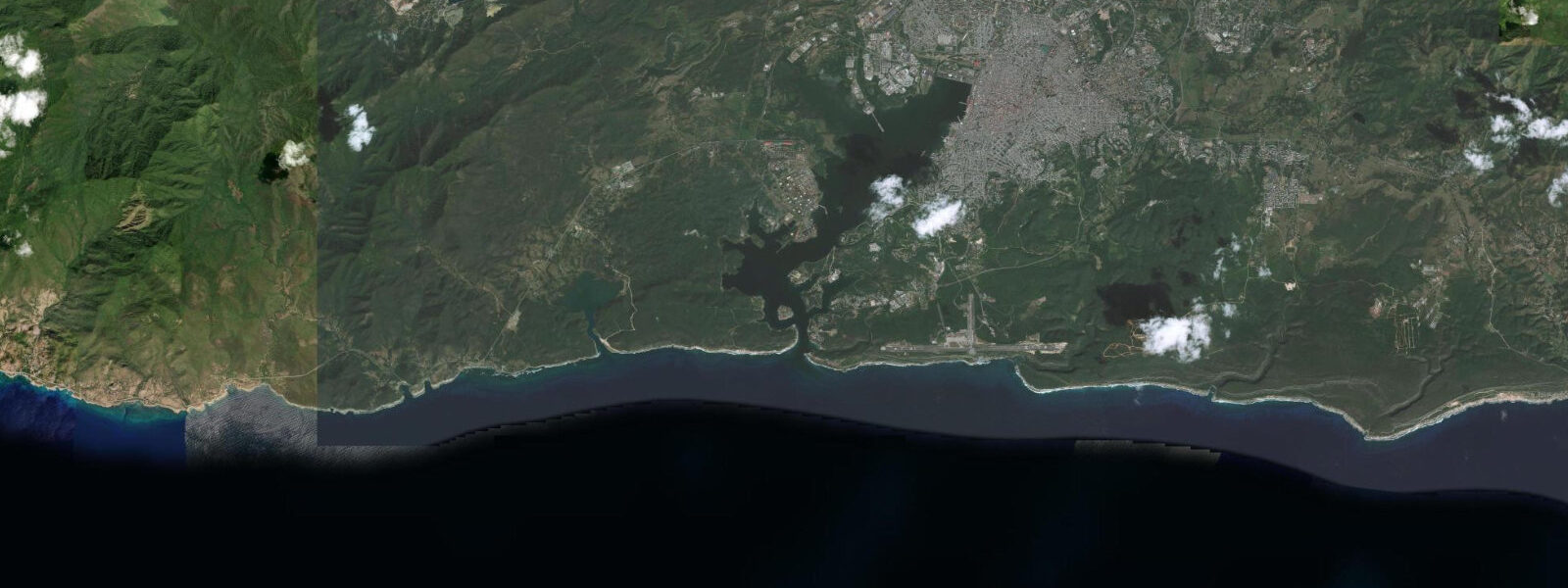
Santiago de Cuba sits at the head of a deep, bottle-shaped bay on the south coast of Cuba, enclosed on all sides by hills and accessible from the Caribbean Sea through a narrow entrance channel barely 200 metres wide between two fortresses. Castillo del Morro de Santiago de Cuba — the 17th-century Spanish fortification on the eastern headland, distinct from and older than the more photographed Morro in Havana — commands the southern entrance wall while Punta Gorda closes the western side. The channel between them is the only way in or out, and it focuses every tidal exchange the bay makes with the Caribbean into that single passage.
The tidal regime inside the bay is mixed semidiurnal and genuinely small. Mean astronomical range in the open Caribbean south of the entrance runs roughly 30 to 50 cm; inside the harbour, the restricted entrance damps it further to perhaps 20 to 35 cm on spring tides, with two unequal highs and two unequal lows each day. The diurnal inequality means one of the daily highs is consistently stronger than the other. On a typical day the predicted water-level swing through the inner harbour is smaller than the chop on a light-breeze afternoon. The non-astronomical drivers — Caribbean swell wrapping through the Windward Passage, the seasonal north winds of the Cuban winter, tropical disturbance passages — matter more than the tide table for most practical purposes. The Instituto Cubano de Hidrografía (GEOCUBA) is the authoritative tidal reference for Cuban waters; predictions on this page come from Open-Meteo Marine, a gridded global ocean model, accurate to approximately ±45 min and ±0.2–0.3 m.
For shore anglers, the Malecón — the seafront boulevard that runs along the inner harbour from the ferry terminal west past the Parque de los Estudiantes — is the working waterfront for casting. The rocky shelf and harbour wall below the Malecón hold jack crevalle, snapper, and occasional tarpon early in the morning on the incoming tide. The ferry crossing from the city pier to La Punta, on the western harbour bank, takes about eight minutes and gives access to a different angle on the entrance channel and the rocky points at the foot of Punta Gorda; the ferry runs on a schedule independent of the tide. The Río Yayabo mouth and the Bahía de Santiago's mangrove edges east of the main port offer kayak access to sheltered water.
The harbour entrance itself is the most interesting tidal location in Santiago de Cuba. At the maximum spring ebb the current through the 200-metre channel between the two fortifications runs perceptibly — standing on the Morro terrace you can watch the water direction change as the tide turns, though the current speed is modest by open-coast standards. Snorkellers working the base of the Morro cliff below the fort walls find the best visibility on the incoming tide, when the cleaner Caribbean water pushes into the channel before the harbour's own turbidity mixes it.
Photographers working the city have a strong set of vantage points that vary with the light rather than the tide. The terrace of Castillo del Morro faces southwest across the entrance to the Sierra Maestra backdrop and is best at sunrise from the bay side and late afternoon from the seaward side. The Loma de San Juan — the hill above the Reparto Vista Alegre neighbourhood where US and Cuban forces fought in 1898 — gives a high view over the inner harbour and the container port. The Cementerio de Santa Ifigenia, where José Martí is buried, sits northwest of the historic centre and is unrelated to the waterfront, but the walk from the centre passes the Via Crucis waterfront road with harbour views.
For beach access, the nearest options are at the Bahía de Siboney, about 16 km southwest along the coast road, and the Baconao reserve beaches further east. The inner harbour itself is an industrial and ferry port; swimming from the city waterfront is not the local practice. The Parque Baconao UNESCO Biosphere Reserve, accessible east along the coast highway, is the main recreational coast for Santiago residents.
Predictions on this page come from Open-Meteo Marine, a gridded global ocean model. Accuracy is typically ±45 min on timing and ±0.2–0.3 m on height. At Santiago's inner-harbour range of 20–35 cm, the model's uncertainty can exceed the full astronomical signal. For navigation in or out of Bahía de Santiago de Cuba, use GEOCUBA harmonic predictions and the official Cuban charts.
Tide questions about Santiago de Cuba
Quick answers to the most common questions about tide times, range, and water access at Santiago de Cuba.
When is the next high tide at Santiago de Cuba?
The hero block at the top of this page shows the next predicted high at Santiago de Cuba in local Cuba Standard Time (CST/CDT, UTC-5/UTC-4 with daylight saving in effect May through October). The astronomical range inside the harbour is roughly 20 to 35 cm — small enough that wind and weather routinely produce larger water-level changes than the tide itself. The Instituto Cubano de Hidrografía (GEOCUBA) publishes the authoritative harmonic predictions for Cuban ports, including Santiago de Cuba, and is the definitive source for any activity where precise water level matters.
Why is the tidal range smaller inside the bay than on the open coast?
Santiago de Cuba Bay is bottle-shaped, roughly 4 km across inside but connected to the Caribbean through a single entrance channel barely 200 metres wide between Castillo del Morro de Santiago and Punta Gorda. That restricted throat limits how much water can exchange between the bay and the open sea in each half-cycle. The result is that the tidal range inside the harbour is measurably smaller than the range in the open Caribbean south of the entrance — roughly 20 to 35 cm inside versus 30 to 50 cm on the outer coast during spring tides. The same geometry makes the current through the entrance channel perceptible even though the tidal range is small: all of the bay's tidal exchange is concentrated into that one narrow passage.
Where do these tide predictions come from?
Open-Meteo Marine, a free gridded global ocean model. The model estimates tidal height across a geographic grid rather than computing from harmonic analysis of the local Santiago de Cuba gauge record. Accuracy is typically within ±45 minutes on timing and ±0.2 to 0.3 metres on height. At Santiago's inner-harbour range of 20 to 35 cm, the model's timing and height uncertainty can each be a meaningful fraction of — and in some tidal cycles, exceed — the total astronomical signal. The Instituto Cubano de Hidrografía (GEOCUBA) is the authoritative source for Cuban tide data; their harmonic predictions for Santiago de Cuba are based on decades of local gauge records.
When is the best time to fish from the Santiago de Cuba Malecón?
Shore anglers on the Santiago de Cuba Malecón and harbour wall consistently prefer the early morning incoming tide — roughly the two hours before and one hour after the predicted low — when water clarity in the harbour improves as Caribbean water pushes through the entrance channel. Jack crevalle and snapper are the main targets from the rocky shelf below the Malecón, with the best activity typically in the first two hours of daylight before harbour boat traffic increases. The angler tradition that uses moon transits to rate fishing days (the solunar approach) rates sessions nearest new and full moon highest — the same lunar phase that produces the largest tidal range and the strongest current through the entrance. The current through the Morro channel is at its strongest midway between the predicted high and low, which is also when the exchange of water from outside is at its maximum; this corresponds with the windows anglers in the harbour report as most productive.
Is this safe to use for navigation?
No. Bahía de Santiago de Cuba is a working commercial port with significant vessel traffic including container ships, ferries, and naval vessels. The entrance channel between Castillo del Morro de Santiago and Punta Gorda is narrow and requires licensed pilotage for commercial vessels. For any vessel operation in or around Santiago de Cuba harbour, use the official Cuban charts published by GEOCUBA, the Instituto Cubano de Hidrografía harmonic predictions, and the relevant Avisos a los Navegantes. Open-Meteo Marine gridded predictions are not gauge-calibrated harmonic data and do not replace authoritative sources for navigation.
7-day tide table — Santiago de Cuba
Heights relative to MSL. Predictions: Open-Meteo Marine (MeteoFrance SMOC, 0.08° grid) — heights relative to MSL (not chart datum / LAT). Model-derived.
| Day | Type | Time | Height |
|---|---|---|---|
| Sun 21 Jun | Low | 09:10 | 0.2m |
| High | 16:10 | 0.4m | |
| Low | 22:00 | 0.3m | |
| Mon 22 Jun | High | 17:10 | 0.4m |
| Tue 23 Jun | Low | 11:00 | 0.1m |
| High | 18:10 | 0.4m | |
| Wed 24 Jun | Low | 11:10 | 0.2m |
| High | 19:10 | 0.5m | |
| Thu 25 Jun | Low | 12:10 | 0.2m |
| High | 19:45 | 0.5m | |
| Fri 26 Jun | — | ||
| Sat 27 Jun | Low | 13:10 | 0.1m |
| High | 19:00 | 0.5m | |