Fernando de Noronha tide times
Fernando de Noronha tide forecast — heights relative to MSL.
Today's tide times for Fernando de Noronha
Tide times at Fernando de Noronha on Sunday, 21 June 2026: first high tide at 08:48, first low tide at 15:14. Sunrise 05:14, sunset 17:08.
Tide chart for Fernando de Noronha
24-hour cosine-interpolated curve around the present moment. Heights relative to MSL. Predictions: Predictions: Open-Meteo Marine (MeteoFrance SMOC, 0.08° grid).
Sun, moon and conditions on Sun 21 Jun
Snapshot at build time — refreshes daily. Sea state from Open-Meteo Marine.
Highs and lows next 7 days
Every predicted high and low for the next week, with the daily tidal coefficient (0–120; higher = bigger swing, > 95 means stronger currents).
Other spots nearby
The three closest curated TideTurtle locations to Fernando de Noronha, measured by great-circle distance.
Today's solunar windows
Solunar tradition: major periods are the ≈3h windows around moon transit and opposition; minor are ≈2h around moonrise and moonset. Pair with the local tide stage and wind for the best read.
Cycle dates near Fernando de Noronha
Last spring tide on Sat 20 Jun (range 1.4m). Next spring tide on Fri 26 Jun (range 1.5m). Next neap on Tue 23 Jun.
Spring tides cluster around new and full moons (biggest swings). Neap tides land on quarter moons (smallest swings). See the spring tide and neap tide glossary entries for the why.
About tides at Fernando de Noronha
A short guide to the coastline at Fernando de Noronha — geography, sea state, and what the tide is actually doing under your feet.
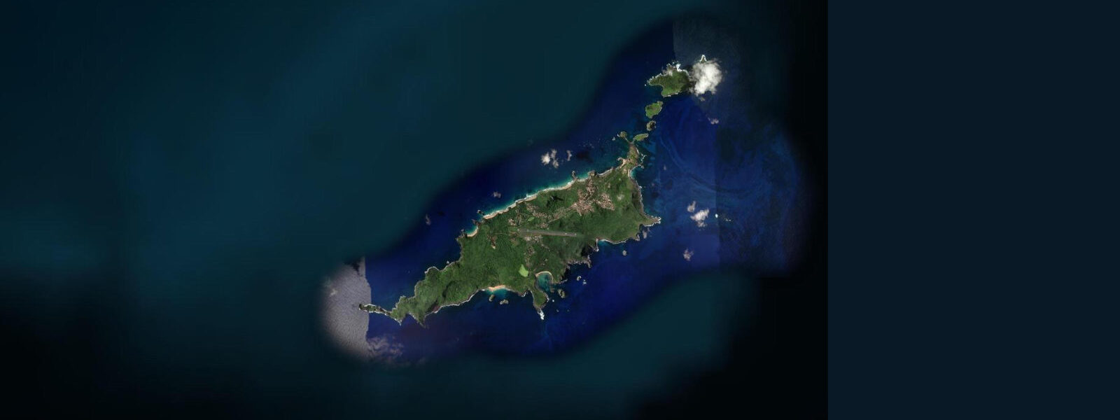
Fernando de Noronha is a volcanic oceanic archipelago 530 kilometres off the Pernambuco coast — the most remote and tightly managed tourism destination in Brazil. The main island and its 20 surrounding islets form a federal conservation unit and UNESCO World Heritage Site; daily visitor numbers are capped and an environmental preservation fee applies for each day of stay, increasing with the length of visit. The restrictions exist because the marine environment is the asset.
Tidal range at Fernando de Noronha is approximately 2.0 to 2.5 metres, mesotidal and semidiurnal — the same tidal character as the Pernambuco mainland, 530 kilometres to the west. The tidal cycle exposes rocky reef flats and intertidal shelves around the island margins at low water, and the reef systems are accessible to snorkellers and divers at all tidal stages, though the intertidal reef walk at places like Praia do Boldró and Baía do Sueste is best timed to the lower half of the tidal range.
The diving at Fernando de Noronha is among the most technically rated in the South Atlantic. Visibility routinely reaches 30 to 40 metres in calm conditions. The Baía dos Golfinhos (Bay of Dolphins) on the north coast holds a year-round resident aggregation of spinner dolphins (Stenella longirostris) — typically 300 to 1,200 individuals that rest in the bay during the morning hours before heading offshore to feed. The bay is a no-entry diving zone but is viewable from the clifftops at the Mirante dos Golfinhos. Dolphin behaviour in the bay changes with tidal state, with the aggregation typically leaving the bay as the tide falls and returning on the flood.
The beaches on the south-facing coast (Baía do Sancho, Praia do Leão, Cacimba do Padre) receive South Atlantic swell and produce the best surf on the archipelago. Sancho, consistently rated among the most beautiful beaches in Brazil, is reached by a steel ladder descent through a cleft in the basalt cliff — access that limits crowding naturally. Sea turtles nest on Praia do Leão and Praia do Sueste; the TAMAR project (Brazilian sea turtle conservation programme) monitors nests and conducts night patrols during the nesting season (January through August for hawksbill turtles).
Logistical reality: flights from Recife or Natal (roughly 90 minutes) are the only way in. Accommodation is almost entirely pousadas (guesthouses), many with diving operations attached. The island has one main settlement, Vila dos Remédios, with the 18th-century fortress of Nossa Senhora dos Remédios visible on the ridge above the anchorage.
Predictions on this page come from Open-Meteo Marine, a global gridded ocean model accurate to within approximately ±45 minutes on timing and ±0.2–0.3 metres on height. For authoritative Brazilian tidal predictions, consult DHN/FEMAR at mar.mil.br/dhn.
Tide questions about Fernando de Noronha
Quick answers to the most common questions about tide times, range, and water access at Fernando de Noronha.
What is the tidal range at Fernando de Noronha?
Fernando de Noronha has a mean tidal range of approximately 2.0 to 2.5 metres — semidiurnal and mesotidal, consistent with the northeast Brazilian coast. The tidal cycle affects intertidal reef access and the morning behaviour of spinner dolphins in the Baía dos Golfinhos. DHN/FEMAR publishes authoritative tidal predictions for the archipelago.
Can I see the spinner dolphins at Fernando de Noronha?
The Baía dos Golfinhos holds a resident aggregation of 300 to 1,200 spinner dolphins that rest in the bay during morning hours. Entry into the bay by swimmers or boats is prohibited to protect the dolphins. The best observation point is the Mirante dos Golfinhos — a clifftop lookout with a direct view into the bay. Arrive by 07:00 to 08:00 for the highest density before the dolphins leave for offshore feeding, typically as the tide falls. Interaction with dolphins in open water outside the bay is regulated; follow current IBAMA guidelines.
How do I get to Fernando de Noronha?
Flights from Recife (roughly 90 minutes) and Natal (roughly 75 minutes) serve the island's small airport. There is no sea transport option for tourists. Daily visitor numbers are capped; booking flights and accommodation well in advance is essential for peak season (December through March and July). An environmental preservation fee (TPA) applies per person per day of stay, increasing after the sixth day — factor this into the total cost.
What is the diving like at Fernando de Noronha?
Visibility of 30 to 40 metres in calm conditions makes Fernando de Noronha among the technically rated dive destinations in the South Atlantic. The main sites include the Cabeço de Alexandre (a seamount rising from 25 metres to 5 metres), the wrecks in Baía do Porto, and the reef systems around the main island. Reef sharks, turtles, large grouper, and moray eels are routine sightings. Dive operators are based in Vila dos Remédios; certification to at least Open Water level required for most sites.
Are the tide predictions on this page suitable for navigation to Fernando de Noronha?
No. Predictions here come from Open-Meteo Marine, a global ocean model providing indicative guidance only — typical accuracy ±45 minutes on timing and ±0.2–0.3 metres on height. For navigation to the archipelago anchorage, use DHN/FEMAR authoritative tidal predictions at mar.mil.br/dhn and official Brazilian nautical charts. The anchorage at Vila dos Remédios is open roadstead; sea conditions change rapidly with the trade wind cycle and swell from the south.
7-day tide table — Fernando de Noronha
Heights relative to MSL. Predictions: Open-Meteo Marine (MeteoFrance SMOC, 0.08° grid) — heights relative to MSL (not chart datum / LAT). Model-derived.
| Day | Type | Time | Height |
|---|---|---|---|
| Sun 21 Jun | High | 08:48 | 0.8m |
| Low | 15:14 | -0.7m | |
| Mon 22 Jun | High | 09:51 | 0.7m |
| Low | 16:12 | -0.6m | |
| Tue 23 Jun | High | 10:55 | 0.6m |
| Wed 24 Jun | Low | 05:43 | -0.5m |
| High | 11:58 | 0.6m | |
| Low | 18:06 | -0.5m | |
| Thu 25 Jun | High | 00:22 | 0.6m |
| Low | 06:42 | -0.6m | |
| High | 12:51 | 0.6m | |
| Low | 18:57 | -0.6m | |
| Fri 26 Jun | High | 01:12 | 0.7m |
| Low | 19:42 | -0.6m | |
| Sat 27 Jun | High | 01:58 | 0.7m |
| Low | 08:15 | -0.7m | |
| High | 14:23 | 0.6m | |
| Low | 20:00 | -0.7m |