Bridgetown tide times
Bridgetown tide forecast — heights relative to MSL.
Today's tide times for Bridgetown
Tide times at Bridgetown on Friday, 19 June 2026: first high tide at 05:55am, first low tide at 12:47pm, second high tide at 07:18pm. Sunrise 05:32am, sunset 06:26pm.
Tide chart for Bridgetown
24-hour cosine-interpolated curve around the present moment. Heights relative to MSL. Predictions: Predictions: Open-Meteo Marine (MeteoFrance SMOC, 0.08° grid).
Sun, moon and conditions on Fri 19 Jun
Snapshot at build time — refreshes daily. Sea state from Open-Meteo Marine.
Highs and lows next 7 days
Every predicted high and low for the next week, with the daily tidal coefficient (0–120; higher = bigger swing, > 95 means stronger currents).
Other spots nearby
The three closest curated TideTurtle locations to Bridgetown, measured by great-circle distance.
Today's solunar windows
Solunar tradition: major periods are the ≈3h windows around moon transit and opposition; minor are ≈2h around moonrise and moonset. Pair with the local tide stage and wind for the best read.
Cycle dates near Bridgetown
Last spring tide on Thu 18 Jun (range 0.7m). Next spring tide on Mon 22 Jun (range 0.4m). Next neap on Sun 21 Jun.
Spring tides cluster around new and full moons (biggest swings). Neap tides land on quarter moons (smallest swings). See the spring tide and neap tide glossary entries for the why.
About tides at Bridgetown
A short guide to the coastline at Bridgetown — geography, sea state, and what the tide is actually doing under your feet.
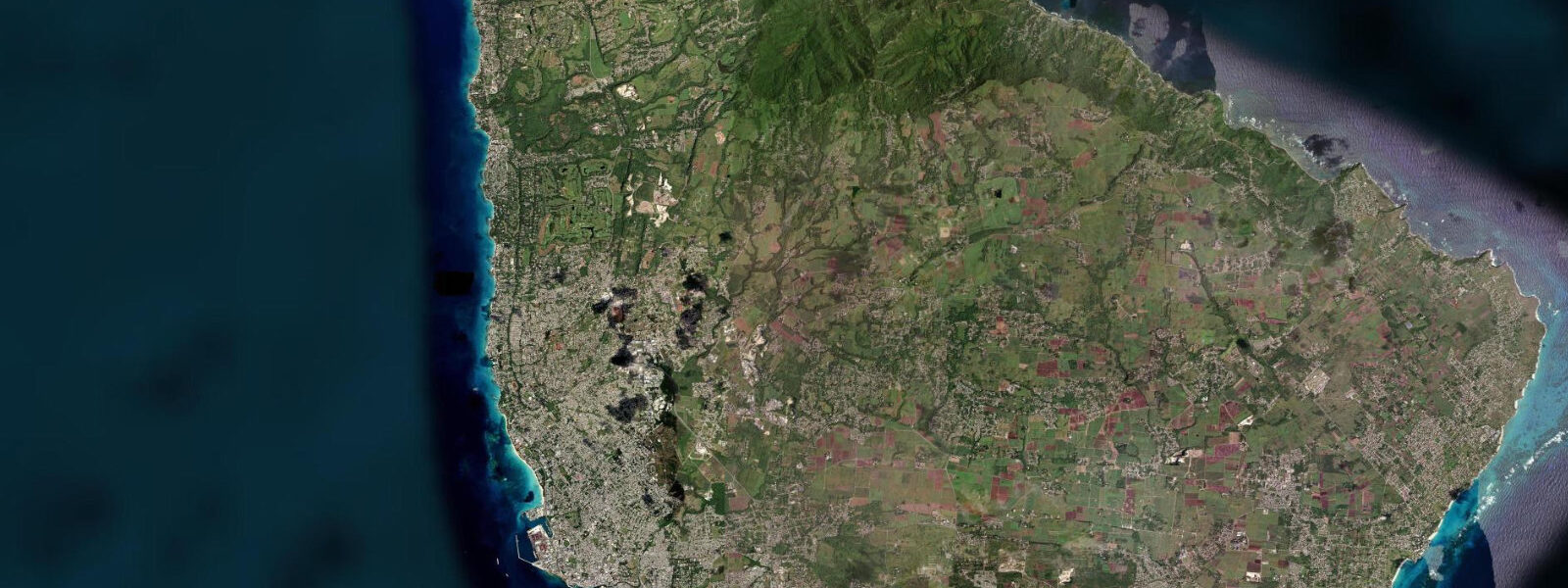
Bridgetown is the capital of Barbados and the only city in the eastern Caribbean with a UNESCO World Heritage designation for its historic core — a recognition of the intact Scottish merchant streetscape, the Careenage (the inner tidal inlet that gave the city its working harbour), and the parliament buildings that have been in continuous use since 1639. The city sits on the southwest coast of Barbados, the most easterly island in the Lesser Antilles, positioned where the island faces the calm Caribbean rather than the Atlantic trade-wind side.
Tidal range at Bridgetown is 0.3 to 0.7 metres — the Caribbean Sea has a semi-diurnal pattern but the range is modest compared to Atlantic coasts. Sea level here is more affected by trade-wind patterns and passing tropical systems than by gravitational tides. The Careenage — the inner harbour inlet that historically served as the careening basin where ships' hulls were scraped — is still the focal point of the waterfront, now lined with restaurants and rum shops.
The Carlisle Bay Marine Park, immediately south of the city, is the premier diving and snorkelling destination on this coast. Six wrecks lie within recreational diving depth in the bay, including the Stavronikita (a 110-metre Greek freighter scuttled in 1978 at 37 metres, now heavily encrusted and home to massive schools of fish) and four more accessible wrecks at 6–15 metres suitable for snorkellers and entry-level divers. Sea turtles — hawksbill and leatherhead — feed and rest on the bay floor and are reliably encountered. The beach at Brownes Beach (Carlisle Bay) is public and free.
St. Lawrence Gap, a short drive south of the city along the southwest coast, is the tourist strip — beach bars, restaurants, and the beach clubs that access the calm leeward coast water. The surf side of Barbados is the east coast (Bathsheba, Soup Bowl) where the Atlantic trade-wind swell arrives uninterrupted from Africa; the west and south coasts are Caribbean-facing and calm, suited to swimming, snorkelling, and flat-water paddling.
Mount Gay Rum — the world's oldest rum brand by documentary evidence (1703) — is produced in the Bridgetown area and runs distillery tours and tastings from the city. The Garrison Savannah area, the UNESCO-listed historic district, contains the Georgian parliament buildings, the Barbados Museum, and the island's colonial military infrastructure. Cricket at Kensington Oval, 1 kilometre from the Careenage, is central to the city's public identity.
Predictions on this page come from Open-Meteo Marine, a gridded global ocean model. Accuracy is typically within plus or minus 45 minutes on timing and 0.2 to 0.3 metres on height — model-derived, not from a local gauge. For authoritative Barbados tide data, consult the Barbados Port Authority.
Tide questions about Bridgetown
Quick answers to the most common questions about tide times, range, and water access at Bridgetown.
What is the tidal range at Bridgetown?
Bridgetown has a modest tidal range of 0.3 to 0.7 metres — the Caribbean is semi-diurnal but with limited range compared to Atlantic coasts. Trade wind patterns and passing tropical systems affect sea level more than the tide curve alone. On the calm leeward (west and southwest) coast, tidal state has minimal practical effect on swimming or snorkelling conditions.
Is Carlisle Bay good for snorkelling?
Yes — Carlisle Bay Marine Park is one of the most accessible shipwreck snorkelling sites in the Caribbean. Four wrecks sit at 6–15 metres, clearly visible from the surface and reachable by snorkellers. Hawksbill and leatherhead sea turtles are regularly seen resting on the sandy bottom. Glass-bottom boat trips run from the beach at Brownes Beach. For deeper diving, the Stavronikita wreck at 37 metres is a major dive site requiring PADI Open Water certification minimum.
Where is the surf on Barbados?
The east coast (windward side) receives the North and South Atlantic swell. Soup Bowl at Bathsheba is the famous break — a powerful right-hander that hosts the annual World Surf League Barbados Pro event. It is an advanced wave; Surfer's Point at Inch Marlow (south coast) is more accessible for intermediate surfers. The west and south coasts that face the Caribbean are generally calm and unsuitable for surfing.
What is the best time of year to visit Bridgetown?
December through April is the dry season — low humidity, trade winds keeping temperatures comfortable (26–28°C), calm Caribbean water. June through November is the hurricane season; Barbados sits at the southern edge of the main hurricane track and is less frequently hit than the northern islands, but weather can be unsettled and some resort facilities reduce capacity. Crop Over festival in July–August is the island's major cultural event.
Can I visit the Mount Gay Rum distillery?
Yes — Mount Gay runs tours and tastings from the visitor centre near Bridgetown. The documentary record of rum production at this site dates to 1703, making it the oldest commercial rum brand. Tours cover the production process from sugarcane molasses through distillation, aging, and blending, and end with a guided tasting of the range. Advance booking is recommended in peak season.
7-day tide table — Bridgetown
Heights relative to MSL. Predictions: Open-Meteo Marine (MeteoFrance SMOC, 0.08° grid) — heights relative to MSL (not chart datum / LAT). Model-derived.
| Day | Type | Time | Height |
|---|---|---|---|
| Fri 19 Jun | High | 05:55 | 0.5m |
| Low | 12:47 | -0.2m | |
| High | 19:18 | 0.4m | |
| Sat 20 Jun | Low | 00:50 | 0.1m |
| High | 06:54 | 0.5m | |
| Sun 21 Jun | Low | 02:15 | 0.1m |
| High | 08:10 | 0.4m | |
| Low | 14:18 | 0.0m | |
| High | 21:10 | 0.4m | |
| Mon 22 Jun | Low | 03:42 | 0.1m |
| High | 09:42 | 0.3m | |
| Low | 15:10 | 0.1m | |
| High | 21:50 | 0.4m | |
| Tue 23 Jun | Low | 04:45 | 0.0m |
| High | 22:50 | 0.5m | |
| Wed 24 Jun | — | ||
| Thu 25 Jun | Low | 06:54 | -0.0m |
| High | 13:15 | 0.3m | |
| Low | 18:00 | 0.2m | |