Conset Bay, Barbados tide times
Conset Bay, Barbados tide forecast — heights relative to MSL.
Today's tide times for Conset Bay, Barbados
Tide times at Conset Bay, Barbados on Saturday, 4 July 2026: first high tide at 05:12am, first low tide at 11:52am, second high tide at 06:18pm. Sunrise 05:36am, sunset 06:28pm.
Tide chart for Conset Bay, Barbados
24-hour cosine-interpolated curve around the present moment. Heights relative to MSL. Predictions: Predictions: Open-Meteo Marine (MeteoFrance SMOC, 0.08° grid).
Sun, moon and conditions on Sat 04 Jul
Snapshot at build time — refreshes daily. Sea state from Open-Meteo Marine.
Highs and lows next 7 days
Every predicted high and low for the next week, with the daily tidal coefficient (0–120; higher = bigger swing, > 95 means stronger currents).
Other spots nearby
The three closest curated TideTurtle locations to Conset Bay, Barbados, measured by great-circle distance.
Today's solunar windows
Solunar tradition: major periods are the ≈3h windows around moon transit and opposition; minor are ≈2h around moonrise and moonset. Pair with the local tide stage and wind for the best read.
Cycle dates near Conset Bay, Barbados
Last spring tide on Fri 03 Jul (range 0.6m). Next spring tide on Wed 08 Jul (range 0.5m). Next neap on Mon 06 Jul.
Spring tides cluster around new and full moons (biggest swings). Neap tides land on quarter moons (smallest swings). See the spring tide and neap tide glossary entries for the why.
About tides at Conset Bay, Barbados
A short guide to the coastline at Conset Bay, Barbados — geography, sea state, and what the tide is actually doing under your feet.
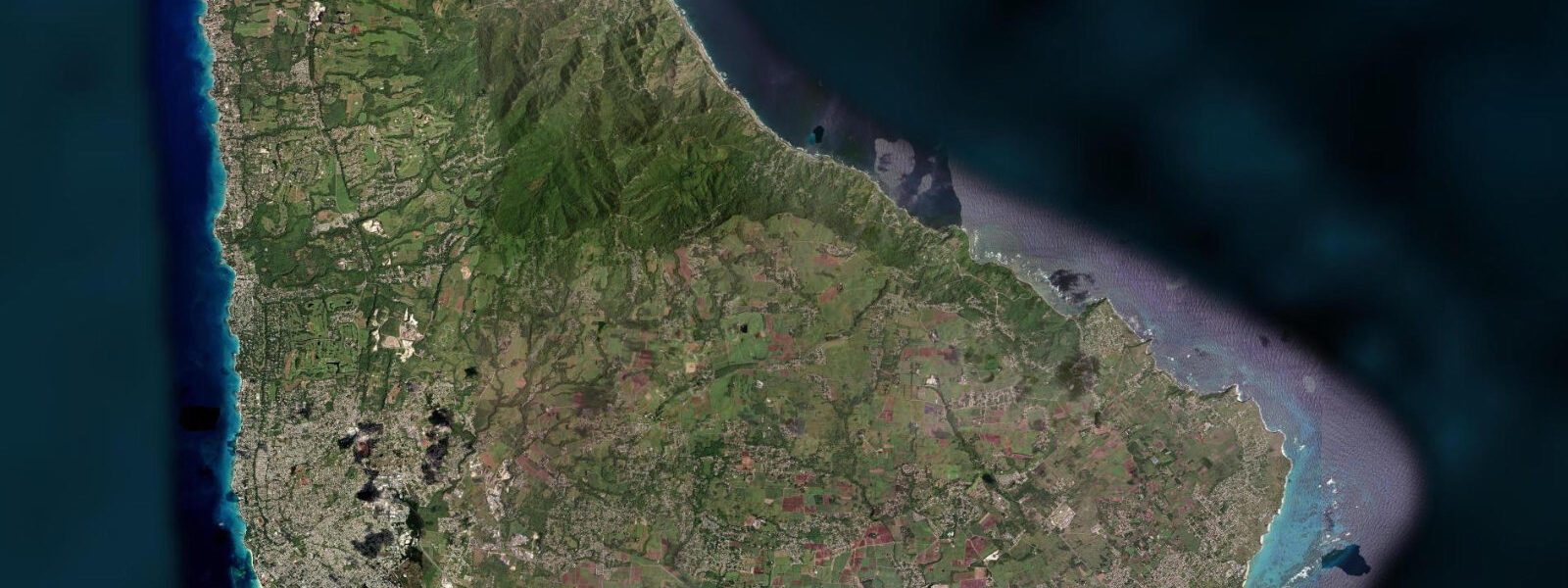
Conset Bay is a small fishing village on the Atlantic-facing east coast of Barbados, south of Bathsheba and Cattlewash, set on a naturally sheltered bay where the reef configuration takes the edge off the Atlantic swell that hammers the more exposed sections of coast. The bay is formed by a shallow horseshoe of reef offshore that partially blocks the direct swell approach, creating calmer conditions inside the reef line than are typical for this coast. The village beach is a short strip of dark volcanic and coral-fragment sand used primarily by the local fishing community; the wooden fishing boats are pulled up on the sand, and the pots and gear are stored on the upper beach above the wave line.
The tidal regime is Atlantic-influenced mixed semidiurnal, with a spring range of 0.6 to 0.8 metres — the full Atlantic signal arrives at this coast, slightly larger than the sheltered Caribbean west coast. Two unequal highs and two unequal lows per day. The reef-sheltered bay configuration makes the tidal stage more consequential here than at fully exposed sections of the east coast: at low water the reef flat inside the bay partly exposes and the pool zone between the inner reef and the beach is accessible for walking and wading; at high water the reef flat is submerged and the water fills the bay to the beach berm.
Conset Bay has a different character to the more visited east coast locations. Bathsheba draws visitors specifically to the Soup Bowl surf break and the distinctive boulder formations; Cattlewash has the long open beach walk. Conset Bay retains its identity as a working fishing village without significant tourist infrastructure. The Flying Fish Inn above the village and a handful of local rum shops are the primary services. This is the authentic east coast working community experience rather than a managed tourism product.
The reef that shelters the bay is a productive snorkelling location in calm conditions. The inner reef flat is accessible on foot at low water; the outer reef requires swimming. Fish diversity on the Atlantic-facing east coast reefs is generally higher than the heavily visited west coast sites, with less bleaching pressure and lower boat traffic. Parrotfish, snapper, and reef fish at unusually high density for a Barbadian reef are characteristic. Visibility is best in the morning before the trade wind picks up.
For anglers, the reef edge outside the bay is accessible by small boat for jigging and bottom fishing. Shore casting from the rocks on the south side of the bay and from the reef flat at low water targets snapper, barracuda, and jacks. The morning on a flooding tide is the consistent productive window. No guide services operate here; knowledge of the specific spots comes from the local fishing community.
Martin's Bay, 5 kilometres south along the coast road, has a similar character with an even more exposed shoreline and some of the most dramatic wave action on the island during strong northeast swell events. The two villages together make a logical east coast circuit from the St. Philip or St. John interior.
Tide predictions for Conset Bay come from Open-Meteo Marine, a global gridded ocean model. Accuracy is typically within plus or minus 45 minutes on timing and 0.2 to 0.3 metres on height. The Atlantic swell forecast matters as much as the tide here; a 2-metre northeast swell raises the effective water level well above the predicted high on the outer reef face.
Conset Bay's position on the east coast road places it between Bathsheba to the north and Martin's Bay to the south, on the circuit that connects the east coast's scattered communities. The road is narrow and the sugar cane fields that border it in places are being progressively replaced by housing and small-scale agriculture as the island's post-sugar land use evolves. The east coast remains the least economically developed section of Barbados, a contrast with the densely built west coast hotel strip that is visible in the landscape and in the pace of daily life.
Tide questions about Conset Bay, Barbados
Quick answers to the most common questions about tide times, range, and water access at Conset Bay, Barbados.
What is the tide range at Conset Bay?
Atlantic-influenced mixed semidiurnal, spring range 0.6 to 0.8 metres. The east coast of Barbados receives the full Atlantic tidal signal, making it slightly larger than the Caribbean west coast range. Two unequal highs and two unequal lows per day; neap range compresses to around 0.4 metres. The reef-sheltered bay at Conset means the tidal exposure of the inner reef flat is a more consequential planning variable than at fully open sections of the east coast: low water exposes the pool zone for wading and snorkelling, high water fills the bay. Tide predictions come from Open-Meteo Marine — accuracy within plus or minus 45 minutes on timing and 0.2 to 0.3 metres on height.
How is Conset Bay different from Bathsheba?
Bathsheba is the most visited east coast location, known for the Soup Bowl surf break and the distinctive mushroom-shaped boulders. It has a car park, a rum shop, and the established George Lamming legacy as a visitor reference point. Conset Bay, 10 kilometres south, is a smaller, quieter fishing village without tourist infrastructure. The bay has partial reef shelter that Bathsheba lacks, producing calmer inside conditions. The reef is more accessible for snorkelling at Conset; the dramatic boulder formations are specific to Bathsheba. If you want a working east coast village experience without the day-tripper presence, Conset is the correct choice.
Can I snorkel at Conset Bay?
Yes. The inner reef flat inside the bay is accessible on foot at low water; the outer reef edge requires swimming. Atlantic-facing east coast reefs in Barbados generally have better fish density and lower bleaching pressure than the more visited west coast sites. Parrotfish, snapper, and reef fish in reasonable numbers are typical. Water clarity is best in the morning before the northeast trade wind picks up and creates surface turbulence. There are no snorkel operators or rental facilities at Conset Bay — bring your own equipment. Entry is directly from the village beach; the bottom is sand and coral rubble.
Is there anywhere to eat or stay at Conset Bay?
Facilities are limited. The Flying Fish Inn above the village is the most established accommodation option in the immediate area, with a guesthouse character rather than resort service. Several rum shops in the village provide drinks and basic food. For a wider range of food options, the St. Philip south coast — Crane Beach, Sam Lord's area — is 15 kilometres south on the coast road, or Six Cross Roads is the main junction town for the eastern parishes. The east coast as a whole has thin tourist infrastructure by design; this is where Barbados looks like it did before the resort era.
When is the best time to visit Conset Bay?
The dry season from January through May gives the most reliable weather, best water clarity, and consistently calm morning conditions before the trade wind fills. The northeast trade swell that drives the Soup Bowl at Bathsheba also affects the outer reef face at Conset; winter swells from November through March produce the most energetic conditions on the Atlantic coast. For snorkelling and reef walking, aim for a low spring tide in the morning of a calm day in February through April. The rainy season from June through November brings heavier swell and reduced visibility but also lower visitor numbers and cooler temperatures inland.
7-day tide table — Conset Bay, Barbados
Heights relative to MSL. Predictions: Open-Meteo Marine (MeteoFrance SMOC, 0.08° grid) — heights relative to MSL (not chart datum / LAT). Model-derived.
| Day | Type | Time | Height |
|---|---|---|---|
| Sat 04 Jul | High | 05:12 | 0.5m |
| Low | 11:52 | -0.1m | |
| High | 18:18 | 0.5m | |
| Sun 05 Jul | Low | 00:00 | 0.1m |
| High | 06:00 | 0.5m | |
| Mon 06 Jul | Low | 00:54 | 0.1m |
| High | 06:45 | 0.4m | |
| Low | 13:10 | 0.0m | |
| High | 19:42 | 0.5m | |
| Tue 07 Jul | Low | 02:00 | 0.1m |
| High | 07:54 | 0.4m | |
| Low | 14:00 | 0.1m | |
| High | 20:20 | 0.5m | |
| Wed 08 Jul | Low | 03:15 | 0.0m |
| High | 09:15 | 0.3m | |
| Low | 14:54 | 0.1m | |
| High | 21:18 | 0.5m | |
| Thu 09 Jul | Low | 04:18 | -0.0m |
| High | 22:18 | 0.5m | |
| Fri 10 Jul | Low | 17:00 | 0.1m |
| High | 19:00 | 0.2m |