Bathsheba, East Coast Barbados tide times
Bathsheba, East Coast Barbados tide forecast — heights relative to MSL.
Today's tide times for Bathsheba, East Coast Barbados
Tide times at Bathsheba, East Coast Barbados on Saturday, 4 July 2026: first high tide at 05:18am, first low tide at 11:50am, second high tide at 06:20pm. Sunrise 05:36am, sunset 06:28pm.
Tide chart for Bathsheba, East Coast Barbados
24-hour cosine-interpolated curve around the present moment. Heights relative to MSL. Predictions: Predictions: Open-Meteo Marine (MeteoFrance SMOC, 0.08° grid).
Sun, moon and conditions on Sat 04 Jul
Snapshot at build time — refreshes daily. Sea state from Open-Meteo Marine.
Highs and lows next 7 days
Every predicted high and low for the next week, with the daily tidal coefficient (0–120; higher = bigger swing, > 95 means stronger currents).
Other spots nearby
The three closest curated TideTurtle locations to Bathsheba, East Coast Barbados, measured by great-circle distance.
Today's solunar windows
Solunar tradition: major periods are the ≈3h windows around moon transit and opposition; minor are ≈2h around moonrise and moonset. Pair with the local tide stage and wind for the best read.
Cycle dates near Bathsheba, East Coast Barbados
Last spring tide on Fri 03 Jul (range 0.6m). Next spring tide on Wed 08 Jul (range 0.5m). Next neap on Mon 06 Jul.
Spring tides cluster around new and full moons (biggest swings). Neap tides land on quarter moons (smallest swings). See the spring tide and neap tide glossary entries for the why.
About tides at Bathsheba, East Coast Barbados
A short guide to the coastline at Bathsheba, East Coast Barbados — geography, sea state, and what the tide is actually doing under your feet.
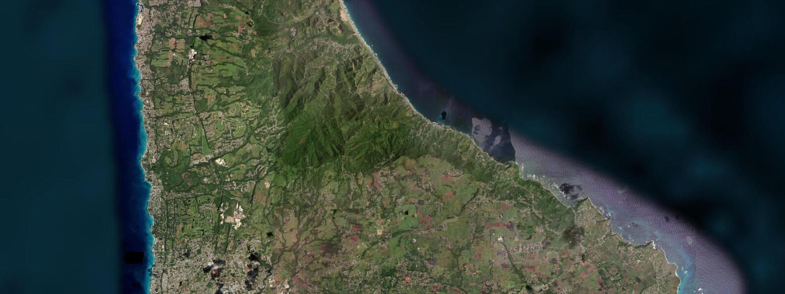
Bathsheba sits on the Atlantic-facing east coast of Barbados, where the trade wind arrives unobstructed from the northeast and the swell has been building since it left the mid-Atlantic. The village is small — a church, a scattering of chattel houses above the road, and the long rock platform and beach below — but it is the most visited point on the east coast for a specific reason: the Soup Bowl. The Soup Bowl is a reef break immediately offshore, named for the churned whitewater that fills the bay between the rock formations during moderate swell.
5 metres or more, and it has hosted professional surfing competitions since the 1970s. The break requires confident swimming ability even for spectators; the rip current on the southern side of the bay is strong on an ebb tide and swell. For everyone who is not surfing, the key activity window at Bathsheba is the low tide rock platform walk.
The large mushroom-shaped boulders that define the bay — Bathsheba's Rock, locally — are the visible tops of an eroded limestone and coral formation; the platform between them and the shore exposes as the water drops to low, revealing interconnected pools, channels, and the ironshore shelf that stretches south toward the Agricultural Station beach. The window runs from roughly 90 minutes before predicted low water to 90 minutes after; outside that window the platform is awash. Footwear is essential — the ironshore edge is sharp, and the rock surface between pools is uneven.
8 metres. The timing and height of the astronomical tide is a planning tool here, not the primary variable; the swell state dominates what is accessible on any given day. 0-metre northeast swell at the 10-second period that characterises the Atlantic trades will wash well above the predicted high-water line on the platform.
The Cattlewash road north from Bathsheba runs along the top of the low cliff and gives elevated views of the full bay arc. Fishing from the rocks on either side of the Soup Bowl is practised by local anglers at first light on the early morning low; the change from ebb to flood produces the slack-water window when predatory fish hold in the channels between the boulders. Photographers come at golden hour — the east-facing coast catches the full morning light, and the boulder formations with the whitewater behind them are one of the more photogenic compositions on the island.
3 metres on height. The swell and wind forecast from the Barbados Meteorological Services should be consulted alongside the tide table for any platform walk or water entry.
Tide questions about Bathsheba, East Coast Barbados
Quick answers to the most common questions about tide times, range, and water access at Bathsheba, East Coast Barbados.
When can I walk the rock platform at Bathsheba?
The rock platform and interconnected pools between the Bathsheba boulders expose as the water drops toward low tide. The accessible window runs from roughly 90 minutes before predicted low to 90 minutes after — check the low tide time on this page, then plan your arrival 90 minutes ahead. On a spring low around new or full moon the platform drains further, revealing more of the ironshore shelf running south. The swell forecast matters at least as much as the tide: a northeast swell above 1.5 metres at a 10-second period will wash the platform even during the low water window. Check the Barbados Meteorological Services swell forecast alongside the tide table.
What is the Soup Bowl and when is it best?
The Soup Bowl is the reef break immediately offshore from Bathsheba beach, named for the churned whitewater that forms in the bay during moderate swell. It is a left-breaking wave that works on northeast and north swells of 1.5 metres or more. The break has hosted professional surfing competitions since the 1970s and is considered the most consistent wave in Barbados. It is not a beginners' break; the rip current on the southern side of the bay runs strongly on an ebb tide and swell combination. Spectators watching from the beach should be aware that the wash from larger sets can reach beyond the normal dry sand zone during high tide.
What is the typical tide range at Bathsheba?
The mixed semidiurnal Atlantic-influenced tide at Bathsheba has a spring range of roughly 0.6 to 0.8 metres — slightly larger than the sheltered south coast because the east coast picks up the full Atlantic tidal signal without the shelter of the Caribbean Sea. Two unequal highs and two unequal lows each day. Spring tides around new and full moons push the range toward 0.8 metres; neap tides compress it. Atlantic swell and trade wind setup routinely push water level above the predicted high; the tide table is a guide to the platform exposure window, not a precise water-level forecast on a swell day.
Where do the tide predictions for Bathsheba come from?
Open-Meteo Marine, a free gridded global ocean model. The model estimates tidal height from oceanographic equations applied across a geographic grid rather than from harmonic analysis of a dedicated gauge at Bathsheba. Accuracy is typically within plus or minus 45 minutes on timing and 0.2 to 0.3 metres on height. For authoritative Barbados tide data, the Caribbean Meteorological Organisation and the Barbados Coast Guard publish port tide information for Bridgetown Harbour, which can be used as a regional reference with the east coast phase offset applied.
Is this safe to use for navigation?
No. TideTurtle is a coastal planning tool, not a nautical authority. The east coast of Barbados has no commercial harbour; navigation in the nearshore waters requires awareness of the reef structures, the Atlantic swell state, and the rip current pattern at Bathsheba Bay. Open-Meteo Marine gridded predictions do not replace authoritative chart data or experienced local knowledge for vessel operations on this coast. For any vessel approaching the east coast, consult the Eastern Caribbean charts and Notices to Mariners from the Caribbean Hydrographic Institute.
7-day tide table — Bathsheba, East Coast Barbados
Heights relative to MSL. Predictions: Open-Meteo Marine (MeteoFrance SMOC, 0.08° grid) — heights relative to MSL (not chart datum / LAT). Model-derived.
| Day | Type | Time | Height |
|---|---|---|---|
| Sat 04 Jul | High | 05:18 | 0.5m |
| Low | 11:50 | -0.0m | |
| High | 18:20 | 0.5m | |
| Sun 05 Jul | Low | 00:06 | 0.1m |
| High | 06:00 | 0.5m | |
| Mon 06 Jul | Low | 00:54 | 0.1m |
| High | 06:45 | 0.4m | |
| Low | 13:06 | 0.0m | |
| High | 19:42 | 0.5m | |
| Tue 07 Jul | Low | 02:00 | 0.1m |
| High | 07:54 | 0.4m | |
| Low | 14:00 | 0.1m | |
| High | 20:18 | 0.5m | |
| Wed 08 Jul | Low | 03:18 | 0.0m |
| High | 09:18 | 0.3m | |
| Low | 14:54 | 0.1m | |
| High | 21:20 | 0.5m | |
| Thu 09 Jul | Low | 04:20 | -0.0m |
| High | 11:00 | 0.3m | |
| Low | 15:50 | 0.1m | |
| High | 22:18 | 0.5m | |
| Fri 10 Jul | Low | 17:00 | 0.1m |
| High | 19:00 | 0.2m |