Mar del Plata, Buenos Aires tide times
Mar del Plata, Buenos Aires tide forecast — heights relative to MSL.
Today's tide times for Mar del Plata, Buenos Aires
Tide times at Mar del Plata, Buenos Aires on Sunday, 26 July 2026: first low tide at 10:00, first high tide at 16:24. Sunrise 07:55, sunset 17:57.
Tide chart for Mar del Plata, Buenos Aires
24-hour cosine-interpolated curve around the present moment. Heights relative to MSL. Predictions: Predictions: Open-Meteo Marine (MeteoFrance SMOC, 0.08° grid).
Sun, moon and conditions on Sun 26 Jul
Snapshot at build time — refreshes daily. Sea state from Open-Meteo Marine.
Highs and lows next 7 days
Every predicted high and low for the next week, with the daily tidal coefficient (0–120; higher = bigger swing, > 95 means stronger currents).
Other spots nearby
The three closest curated TideTurtle locations to Mar del Plata, Buenos Aires, measured by great-circle distance.
Today's solunar windows
Solunar tradition: major periods are the ≈3h windows around moon transit and opposition; minor are ≈2h around moonrise and moonset. Pair with the local tide stage and wind for the best read.
Cycle dates near Mar del Plata, Buenos Aires
Next spring tide on Mon 27 Jul (range 1.2m). Last neap on Sat 25 Jul. Next neap on Thu 30 Jul.
Spring tides cluster around new and full moons (biggest swings). Neap tides land on quarter moons (smallest swings). See the spring tide and neap tide glossary entries for the why.
About tides at Mar del Plata, Buenos Aires
A short guide to the coastline at Mar del Plata, Buenos Aires — geography, sea state, and what the tide is actually doing under your feet.
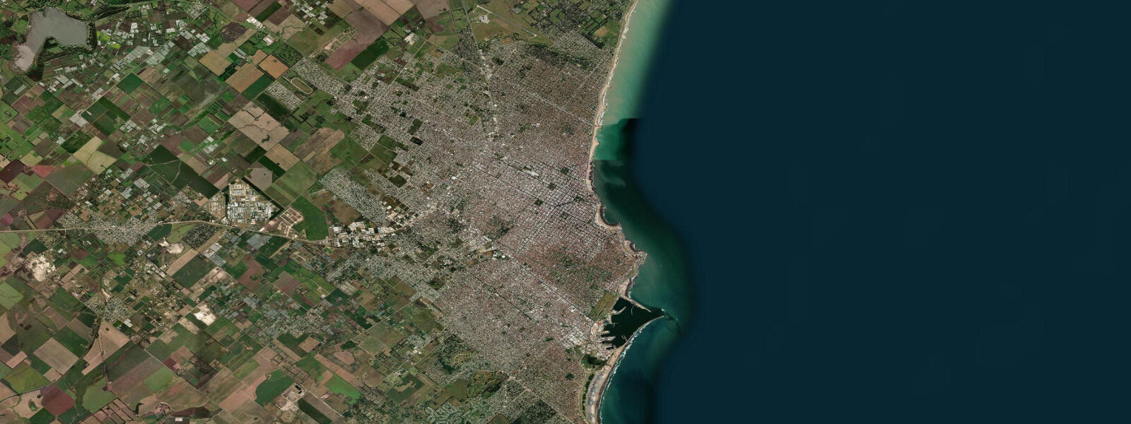
Mar del Plata fronts the South Atlantic on Argentina's mid-latitude coast about 400 kilometres south of Buenos Aires, with the long sand-and-cliff shoreline running from Playa Grande in the north past the working harbour at Cabo Corrientes through Bristol and Varese to the surf coast at Playa Chica and on toward Punta Mogotes lighthouse at the southern edge. The city is the country's marquee summer-holiday destination — the Argentine equivalent of the Jersey Shore writ Atlantic — and the working port handles the largest fishing fleet in the country. 5 on neaps.
The pattern is two highs and two lows of comparable size about twelve and a half hours apart. The defining seasonal force is wind. The pampero front sweeps up off Patagonia in autumn and winter, dropping temperature ten degrees in an afternoon and turning the open coast onshore.
The deeper sudestada develops when a coastal low draws sustained south-east winds across the long fetch of the South Atlantic — the system can pile water against the Argentine coast and lift apparent water levels a metre or more above predicted, and the same wind builds the surf at Cabo Corrientes and Playa Grande into closeout shorebreak. Quequén further south at the Necochea river mouth amplifies surge events through its working port geometry. The sportfishing fleet running for striped marlin, dorado, and pejerrey out of the harbour, the working stevedores on the dock at the wharf, the alfajor-eating beach culture along the Bristol promenade, the surf community at Cabo Corrientes and Playa Chica, and the sea-lion colony that has made the harbour breakwater into Argentina's largest urban pinniped haul-out all read the table for different windows.
Open-Meteo Marine drives the gridded predictions on this page; for authoritative Argentine tide data, the Servicio de Hidrografía Naval of the Argentine Navy publishes the official tide tables and operates the harbour reference gauge.
Tide questions about Mar del Plata, Buenos Aires
Quick answers to the most common questions about tide times, range, and water access at Mar del Plata, Buenos Aires.
When is the next high tide at Mar del Plata?
The hero block shows the next high tide at the Mar del Plata harbour gauge in local Argentine time (ART, UTC-3 year-round, no DST). The 7-day table covers all daily highs and lows. The Quequén harbour 100 kilometres south reads about 30 minutes behind the Mar del Plata gauge on the same flood.
What's the typical tide range at Mar del Plata?
Mean range is about 0.9 metres at the harbour gauge — a moderate semidiurnal swing. Spring tides push close to 1.4 metres and neaps drop near 0.5. Two highs and two lows of comparable size about twelve and a half hours apart. The pattern is cleaner here than further north at the Río de la Plata estuary, where the southerly sudestada wind events override the astronomical signal completely.
Where do these tide predictions come from?
Open-Meteo Marine, a gridded global ocean model. Useful for planning the Bristol and Playa Grande beach windows, the Cabo Corrientes surf sessions, and the harbour-fleet sportfishing departures. For authoritative Argentine tide data, the Servicio de Hidrografía Naval (SHN) publishes the official tide tables and operates the Mar del Plata reference gauge.
How does the sudestada affect water levels at Mar del Plata?
The sudestada is a sustained south-east wind event that develops when a slow coastal low draws air across the long South Atlantic fetch toward the Argentine coast. The wind piles water against the shore and can lift apparent water levels a metre or more above the predicted astronomical tide, particularly when the surge coincides with high tide on a spring cycle. The Río de la Plata at Buenos Aires sees the worst impact because the funnel geometry concentrates the surge; Mar del Plata gets a smaller version of the same effect plus heavy onshore swell on the open coast.
Is this safe to use for navigation?
No. For piloting in or out of the Mar del Plata harbour, transiting the South Atlantic shelf, or working the Quequén approach use the Servicio de Hidrografía Naval authoritative tide tables, the Prefectura Naval Argentina notices to mariners, and the harbour-master pilotage guidance. Sudestada and pampero events can override the harmonic signal entirely and demand real-time forecasts.
7-day tide table — Mar del Plata, Buenos Aires
Heights relative to MSL. Predictions: Open-Meteo Marine (MeteoFrance SMOC, 0.08° grid) — heights relative to MSL (not chart datum / LAT). Model-derived.
| Day | Type | Time | Height |
|---|---|---|---|
| Sun 26 Jul | Low | 10:00 | -0.0m |
| High | 16:24 | 0.6m | |
| Mon 27 Jul | Low | 00:35 | -0.3m |
| High | 17:16 | 0.4m | |
| Tue 28 Jul | Low | 01:02 | -0.5m |
| High | 18:02 | 0.7m | |
| Wed 29 Jul | Low | 02:08 | -0.5m |
| High | 07:10 | 0.0m | |
| Low | 11:18 | -0.2m | |
| High | 18:48 | 0.7m | |
| Thu 30 Jul | Low | 02:48 | -0.5m |
| High | 07:50 | -0.0m | |
| Low | 12:06 | -0.2m | |
| High | 19:20 | 0.7m | |
| Fri 31 Jul | Low | 03:36 | -0.7m |
| High | 08:00 | -0.3m | |
| Low | 13:15 | -0.5m | |
| High | 20:00 | 0.3m | |
| Sat 01 Aug | Low | 03:50 | -0.9m |
| High | 20:00 | 0.6m |