Necochea, Buenos Aires Province tide times
Necochea, Buenos Aires Province tide forecast — heights relative to MSL.
Today's tide times for Necochea, Buenos Aires Province
Tide times at Necochea, Buenos Aires Province on Friday, 19 June 2026: first low tide at 15:50, first high tide at 21:21. Sunrise 08:12, sunset 17:40.
Tide chart for Necochea, Buenos Aires Province
24-hour cosine-interpolated curve around the present moment. Heights relative to MSL. Predictions: Predictions: Open-Meteo Marine (MeteoFrance SMOC, 0.08° grid).
Sun, moon and conditions on Fri 19 Jun
Snapshot at build time — refreshes daily. Sea state from Open-Meteo Marine.
Highs and lows next 7 days
Every predicted high and low for the next week, with the daily tidal coefficient (0–120; higher = bigger swing, > 95 means stronger currents).
Other spots nearby
The three closest curated TideTurtle locations to Necochea, Buenos Aires Province, measured by great-circle distance.
Today's solunar windows
Solunar tradition: major periods are the ≈3h windows around moon transit and opposition; minor are ≈2h around moonrise and moonset. Pair with the local tide stage and wind for the best read.
Cycle dates near Necochea, Buenos Aires Province
Next spring tide on Fri 19 Jun (range 2.1m). Next neap on Wed 24 Jun.
Spring tides cluster around new and full moons (biggest swings). Neap tides land on quarter moons (smallest swings). See the spring tide and neap tide glossary entries for the why.
About tides at Necochea, Buenos Aires Province
A short guide to the coastline at Necochea, Buenos Aires Province — geography, sea state, and what the tide is actually doing under your feet.
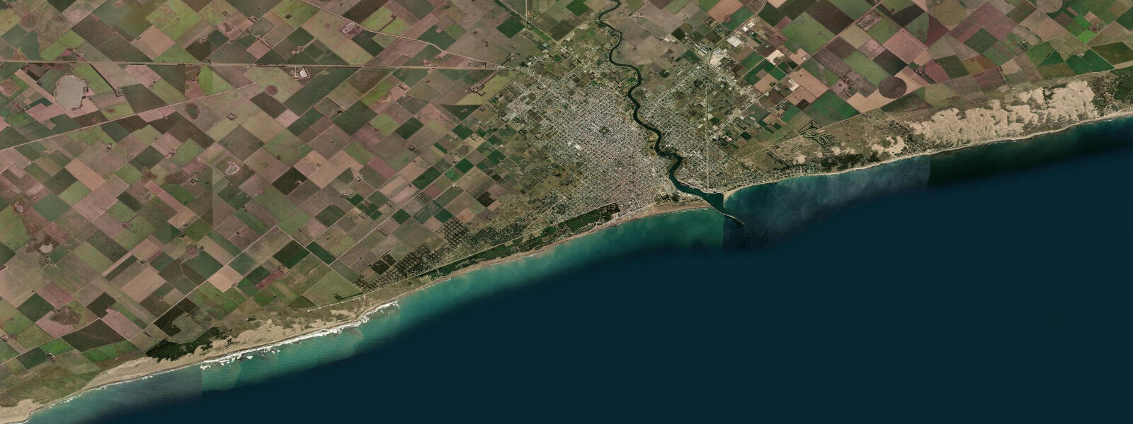
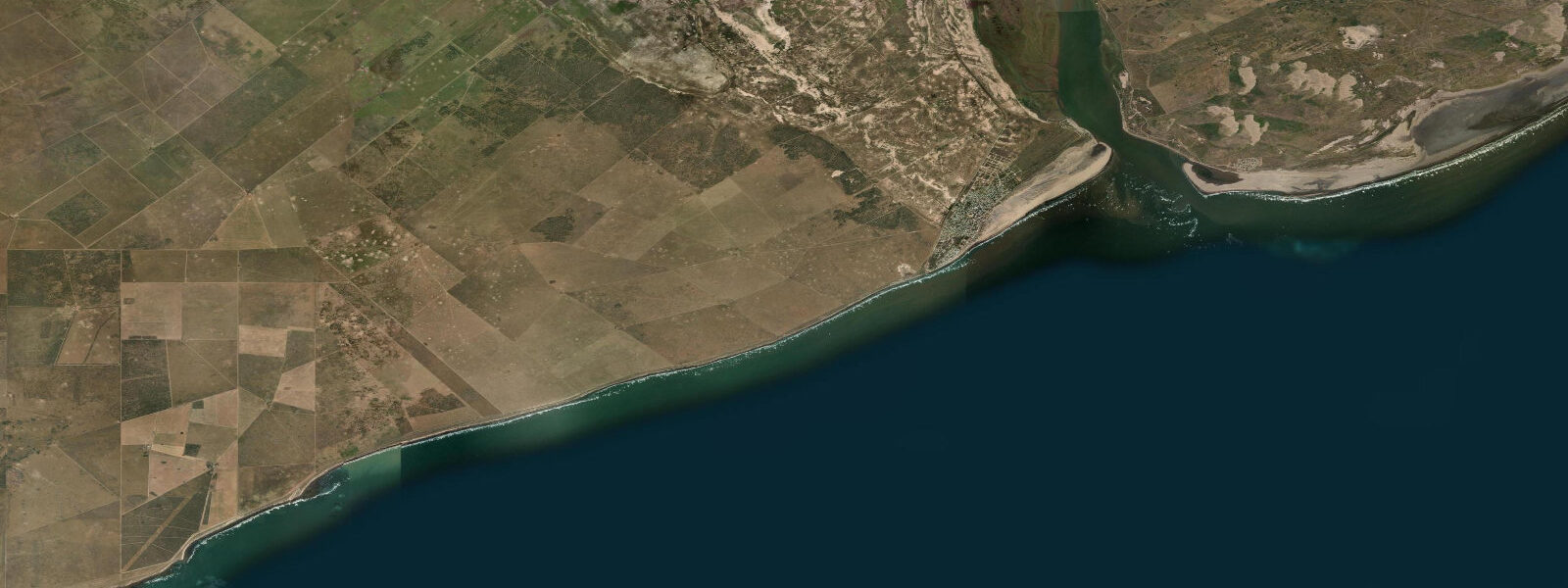
Necochea sits where the Río Quequén Grande reaches the Atlantic, 500 kilometres south of Buenos Aires. On the north bank of the river sits Quequén, the twin port town — Argentina's second-largest grain export terminal after Rosario, loading wheat and soy into Panamax bulk carriers on continuous rotation through the year. The port and the beach coexist in the same geography, the grain silos and ship cranes visible from the sand, which gives Necochea a working character that distinguishes it from the designed resort towns to the north.
The Atlantic tidal regime at Necochea is semidiurnal with a mean spring range of 1.0 to 1.5 metres. A typical spring cycle runs from around 0.2 m at low to 1.4 m at high. The Quequén inlet bar — where the Río Quequén Grande crosses the shallows at the river mouth — is tide-sensitive: bar depth falls below 6 metres on neap low water, which is tight for a loaded Panamax. Harbour pilots time bulk carrier passages through the inlet to the flood, aiming to cross the bar within three hours of high water when tidal uplift adds a reliable 0.8 to 1.0 metres of depth. Port operations at Quequén are continuous, and the nightly sequence of bulk carriers working the entrance at tidal windows is visible from the Necochea beach promenade after dark — running lights on the vessels, the port crane lights, and the lighthouse at the river mouth.
The Necochea beach itself runs 80 kilometres south of the river mouth without interruption — one of the longest continuous beaches in South America. The beach is open Atlantic, facing northeast, exposed to south and southwest swells from the Patagonian Southern Ocean fetch. Shore casting from this beach is productive across a long season. The primary targets are corvina (Micropogonias furnieri, the whitemouth croaker) and pejerrey (Odontesthes bonariensis, the Argentinian silverside). The corvina arrive close inshore on the incoming tide, running the long, shallow surf slope; the most reliable casting window is the last 90 minutes of the flood and the first 60 minutes of the ebb. Pejerrey school in the nearshore zone and respond to small metal lures on a light spinning rod — the rising tide concentrates them at the water's edge.
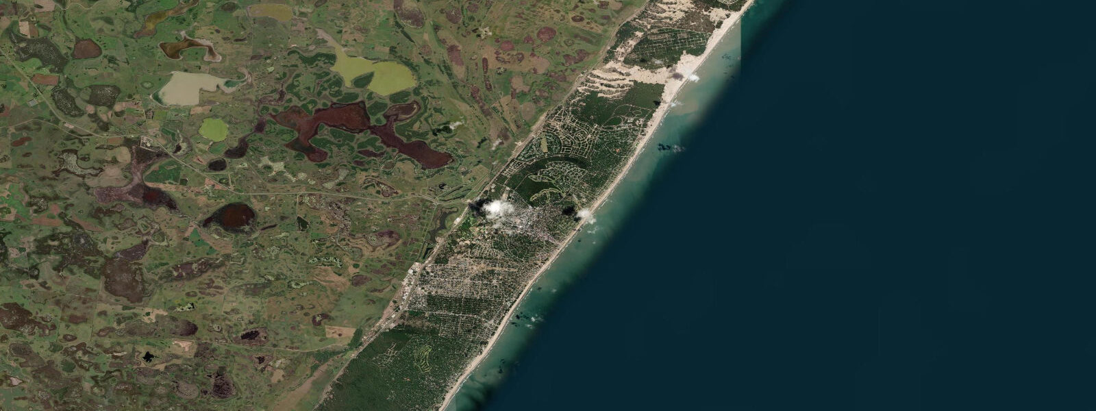
Parque Miguel Lillo is a 23-metre dune system immediately west of the Necochea beach, now a protected natural park with walking and mountain-bike trails through the dunes and native coastal scrub. The park runs parallel to the beach for several kilometres, accessible from multiple entry points along the beach promenade. The highest dune points give a clear view south down the 80-kilometre beach run and north toward the Quequén port cranes. At low tide, the beach beneath the dunes is at its widest — the park's western dune face can be reached in dry-sand conditions only around low water on springs when the beach expands to its full width.
The Río Quequén Grande has a run of peladilla (Percichthys trucha) — a native Patagonian perch — in the estuary in autumn (March through June). The peladilla move into the tidal section of the river on the flood, holding in the current breaks and eddy zones behind the river bend structures inside the port. Fly fishing for peladilla in the lower Quequén requires timing the approach to the flood window and reading the estuary structure; the fish are not large (typically 300 to 800 g) but are a distinctive target in an estuary environment that mixes grain ships and seabirds.
Wind turbines — an aerogenerador farm — are visible south of town from the beach and from vessels passing the coast. The farm sits on the flat Buenos Aires pampas inland from the beach and is visible for 15 to 20 kilometres in clear conditions, becoming a navigation reference point for small boat operators.
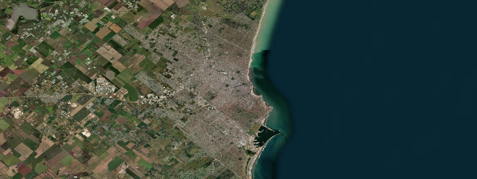
The town of Necochea itself is laid out on a grid behind the beach, without the designed forest character of Pinamar or the resort infrastructure of Mar del Plata. It functions as a working regional centre that also attracts summer beach visitors — the beach crowd is primarily from Buenos Aires Province's interior towns rather than from Buenos Aires city. The January and February peak fills the promenade; the rest of the year the beach is used mainly by locals, anglers, and walkers.
Tide data for Necochea, Buenos Aires Province comes from the Open-Meteo Marine API, a gridded model product. Timing accuracy is ±45 minutes, height accuracy ±0.3 m — usable for trip planning, not for navigation.
Tide questions about Necochea, Buenos Aires Province
Quick answers to the most common questions about tide times, range, and water access at Necochea, Buenos Aires Province.
How does the tide affect navigation through the Quequén port inlet?
The bar at the Río Quequén Grande mouth shallows to under 6 metres on neap low water, which is tight clearance for a loaded Panamax bulk carrier. Harbour pilots at Quequén time bulk carrier passages through the inlet to the flood — aiming to cross the bar within three hours of high water when the tidal uplift adds 0.8 to 1.0 metres of additional depth. The mean spring range at Necochea is 1.0 to 1.5 metres. Port operations run continuously year-round loading wheat and soy, so the tidal management of the inlet is a daily operational task rather than an occasional consideration. Vessel passages through the inlet at night, visible from the beach promenade, follow this tidal schedule.
What is the best tide window for shore fishing at Necochea beach?
Corvina (Micropogonias furnieri, whitemouth croaker) are the primary shore target along Necochea's 80-kilometre beach. They run close inshore on the flood, pushed by the rising water up the long shallow slope. The most reliable window is the last 90 minutes of the flood and the first 60 minutes of the ebb, when the fish are concentrated in the surf zone at maximum tidal coverage. Pejerrey (Argentinian silverside) school at the water's edge and respond to small metal lures on light spinning gear — they're present across the tidal cycle but are most active during the flood. Autumn (March through June) is the best season for both species as water temperatures fall to the 12 to 15°C range.
What is Parque Miguel Lillo and what can I do there?
Parque Miguel Lillo is a protected dune park immediately west of the Necochea beach promenade, with dunes reaching 23 metres and several kilometres of walking and mountain-bike trails through the dunes and native coastal scrub. The park is free to enter with multiple access points from the beach road. The highest dune points give views south down the 80-kilometre uninterrupted beach and north toward the Quequén port cranes. At low spring tide the beach below the park reaches its maximum width — the park's western dune face can be reached on dry sand only in the low-water period, adding an exploratory element to the walk. The park is less visited than the beach itself and provides shelter from the southwest wind that often scours the open strand.
Is there fly fishing for peladilla in the Río Quequén Grande?
Yes — Percichthys trucha (peladilla, a native Patagonian perch) runs into the tidal section of the lower Río Quequén Grande during autumn, March through June. The fish move into the estuary on the flood, holding in current breaks and eddy zones behind the river bend structures within and just above the port area. They are not large — 300 to 800 g is typical — but are a distinctive native species in a brackish estuary setting. Fly fishing from the bank requires timing the approach to the flood window and reading the eddy structure. A provincial fishing licence is required; available from tackle shops in Necochea. The estuary environment mixes working port infrastructure with estuarine ecology in a way that is genuinely unusual.
How long is the Necochea beach and what makes it significant?
The Necochea beach runs 80 kilometres south of the Río Quequén Grande mouth without interruption — no headlands, no river mouths, no built structures breaking the strand. It is one of the longest continuous beaches in South America. The beach faces northeast and is exposed to south and southwest swells from the Patagonian and Southern Ocean fetch, making it a consistent surf casting location across the whole length. The beach width varies 20 to 40 metres between low and high spring water. In January and February the promenade section north of the park fills with summer visitors; the further south you walk along the 80-kilometre strand, the fewer people you encounter — the beach beyond 5 kilometres from the promenade is effectively empty.
7-day tide table — Necochea, Buenos Aires Province
Heights relative to MSL. Predictions: Open-Meteo Marine (MeteoFrance SMOC, 0.08° grid) — heights relative to MSL (not chart datum / LAT). Model-derived.
| Day | Type | Time | Height |
|---|---|---|---|
| Fri 19 Jun | Low | 15:50 | 0.2m |
| High | 21:21 | 1.1m | |
| Sat 20 Jun | Low | 05:19 | -0.9m |
| High | 10:27 | 0.1m | |
| Low | 16:37 | -0.3m | |
| High | 22:21 | 0.8m | |
| Sun 21 Jun | Low | 05:54 | -0.9m |
| High | 11:34 | 0.4m | |
| Low | 17:36 | -0.1m | |
| High | 23:15 | 1.0m | |
| Mon 22 Jun | Low | 06:34 | -0.5m |
| High | 12:16 | 0.7m | |
| Low | 18:50 | -0.1m | |
| Tue 23 Jun | High | 00:22 | 0.9m |
| Low | 07:25 | -0.4m | |
| High | 13:06 | 0.7m | |
| Low | 19:57 | -0.3m | |
| Wed 24 Jun | High | 01:22 | 0.6m |
| Low | 08:06 | -0.5m | |
| High | 14:08 | 0.6m | |
| Low | 20:51 | -0.3m | |
| Thu 25 Jun | High | 14:58 | 0.8m |
| Low | 20:00 | -0.2m |