Rio de Janeiro (Ilha Fiscal) tide times
Rio de Janeiro (Ilha Fiscal) tide forecast — heights relative to MSL.
Today's tide times for Rio de Janeiro (Ilha Fiscal)
Tide times at Rio de Janeiro (Ilha Fiscal) on Sunday, 26 July 2026: first high tide at 13:12. Sunrise 06:29, sunset 17:29.
Tide chart for Rio de Janeiro (Ilha Fiscal)
24-hour cosine-interpolated curve around the present moment. Heights relative to MSL. Predictions: Predictions: Open-Meteo Marine (MeteoFrance SMOC, 0.08° grid).
Sun, moon and conditions on Sun 26 Jul
Snapshot at build time — refreshes daily. Sea state from Open-Meteo Marine.
Highs and lows next 7 days
Every predicted high and low for the next week, with the daily tidal coefficient (0–120; higher = bigger swing, > 95 means stronger currents).
Other spots nearby
The three closest curated TideTurtle locations to Rio de Janeiro (Ilha Fiscal), measured by great-circle distance.
Today's solunar windows
Solunar tradition: major periods are the ≈3h windows around moon transit and opposition; minor are ≈2h around moonrise and moonset. Pair with the local tide stage and wind for the best read.
Cycle dates near Rio de Janeiro (Ilha Fiscal)
Next spring tide on Thu 30 Jul (range 1.1m). Next neap on Sun 26 Jul.
Spring tides cluster around new and full moons (biggest swings). Neap tides land on quarter moons (smallest swings). See the spring tide and neap tide glossary entries for the why.
About tides at Rio de Janeiro (Ilha Fiscal)
A short guide to the coastline at Rio de Janeiro (Ilha Fiscal) — geography, sea state, and what the tide is actually doing under your feet.
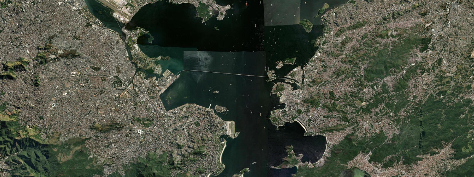
Rio de Janeiro fronts the South Atlantic on Brazil's south-eastern coast, on the long curve of Guanabara Bay between the granite domes of Sugarloaf at the bay mouth and the Corcovado at its back, with Copacabana, Ipanema, and Leblon on the open Atlantic-facing south side and the working port and downtown on the bay side facing Niterói across the water. The Ilha Fiscal harbour gauge sits inside the bay near the historic Real Gabinete Português de Leitura. 0 metre on the largest spring tides and dropping close to flat on neaps.
The astronomical forcing is small because the South Atlantic at this latitude is broad and the continental shelf relatively narrow; the propagating tide reaches the coast as a near-progressive wave rather than building through resonance. What matters more on a day-to-day basis is wind setup from the south-quadrant frentes that sweep up from the South Atlantic — sustained 25-knot southerly winds can lift apparent water level 30 to 50 cm above predicted, and the same wind builds the famous Copacabana surf and the closeout shorebreak on the open Atlantic-facing beaches. Ipanema and Leblon read the swell more than the tide; Vermelha Beach at the foot of Sugarloaf, the protected swimming at Botafogo behind the bay headland, the long Niterói Beach at Icaraí across the water, the rocky intertidal at Arpoador where Ipanema meets Copacabana, and the Pedra do Telégrafo rocks in Barra de Guaratiba west of the city all read the table for different windows.
The lowest spring lows around new and full moons open the rocky shelf at Pedra do Arpoador and the small tidepool zones at Forte de Copacabana for short windows. Open-Meteo Marine drives the gridded predictions on this page; for authoritative Brazilian tide data, the Marinha do Brasil's Centro de Hidrografia da Marinha (CHM) publishes the official tide tables and operates the Ilha Fiscal reference gauge.
Tide questions about Rio de Janeiro (Ilha Fiscal)
Quick answers to the most common questions about tide times, range, and water access at Rio de Janeiro (Ilha Fiscal).
When is the next high tide at Rio de Janeiro?
The hero block shows the next high tide at the Ilha Fiscal harbour gauge in local Brasília time (UTC-3, no DST since 2019). The 7-day table covers all the highs and lows. High water at Niterói across the bay arrives a few minutes after the Ilha Fiscal gauge; on the open Atlantic side at Copacabana the timing leads by about ten minutes.
What's the typical tide range at Rio de Janeiro?
Mean range at the Ilha Fiscal gauge is about 0.6 metres, climbing past 1.0 metre on the largest spring tides and dropping close to flat on neaps. The pattern is mixed semidiurnal — two highs and two lows of unequal size each day — and the range is small because the South Atlantic at this latitude pushes the tide as a near-progressive wave rather than amplifying through resonance against a continental shelf.
Where do these tide predictions come from?
Open-Meteo Marine, a gridded global ocean model. Useful for daily planning around Guanabara Bay, the Copacabana and Ipanema beaches, and the recreational coastline at Barra da Tijuca. For authoritative Brazilian tide data, the Marinha do Brasil's Centro de Hidrografia da Marinha (CHM) publishes the official tide tables and operates the Ilha Fiscal reference gauge.
How does the frente wind affect the tide at Rio?
The astronomical tide range is small, so wind setup matters more than the moon for day-to-day water levels. South-quadrant frentes that sweep up from the South Atlantic can lift apparent water level 30 to 50 cm above predicted while they blow, and the same wind builds the famous Copacabana surf. The combination of spring tide and a sustained southerly frente can produce coastal-flooding events at the low-lying Lagoa Rodrigo de Freitas margins and the marina at Glória.
Is this safe to use for navigation?
No. For piloting in or out of Guanabara Bay, transiting the bay mouth at Sugarloaf, or working the Atlantic-facing beach coast use the Marinha do Brasil's authoritative tide tables, the Praticagem do Rio de Janeiro pilotage guidance, and the Brazilian Navy notices to mariners. The rip currents off Copacabana, Ipanema, and Leblon are working-hazardous in any swell event and the Atlantic-facing beaches are not consistently safe swimming destinations.
7-day tide table — Rio de Janeiro (Ilha Fiscal)
Heights relative to MSL. Predictions: Open-Meteo Marine (MeteoFrance SMOC, 0.08° grid) — heights relative to MSL (not chart datum / LAT). Model-derived.
| Day | Type | Time | Height |
|---|---|---|---|
| Sun 26 Jul | High | 13:12 | 0.3m |
| Mon 27 Jul | Low | 07:13 | -0.6m |
| High | 13:45 | 0.4m | |
| Low | 19:48 | -0.3m | |
| Tue 28 Jul | High | 01:07 | 0.3m |
| Low | 07:47 | -0.6m | |
| High | 14:16 | 0.4m | |
| Low | 20:13 | -0.3m | |
| Wed 29 Jul | High | 01:42 | 0.4m |
| Low | 08:17 | -0.6m | |
| High | 14:46 | 0.5m | |
| Low | 20:40 | -0.2m | |
| Thu 30 Jul | High | 02:12 | 0.5m |
| Low | 08:51 | -0.6m | |
| High | 15:12 | 0.5m | |
| Low | 21:08 | -0.3m | |
| Fri 31 Jul | High | 02:36 | 0.5m |
| Low | 09:22 | -0.6m | |
| High | 15:42 | 0.5m | |
| Low | 21:43 | -0.3m | |
| Sat 01 Aug | High | 03:05 | 0.5m |
| Low | 10:00 | -0.6m | |
| High | 16:00 | 0.4m | |
| Low | 20:00 | -0.1m |