New Orleans, LA tide times
New Orleans, LA tide forecast — heights relative to MSL.
Tide chart for New Orleans, LA
24-hour cosine-interpolated curve around the present moment. Heights relative to MSL. Predictions: Predictions: Open-Meteo Marine (MeteoFrance SMOC, 0.08° grid).
Sun, moon and conditions on Sun 26 Jul
Snapshot at build time — refreshes daily. Sea state from Open-Meteo Marine.
Highs and lows next 7 days
Every predicted high and low for the next week, with the daily tidal coefficient (0–120; higher = bigger swing, > 95 means stronger currents).
Other spots nearby
The three closest curated TideTurtle locations to New Orleans, LA, measured by great-circle distance.
Today's solunar windows
Solunar tradition: major periods are the ≈3h windows around moon transit and opposition; minor are ≈2h around moonrise and moonset. Pair with the local tide stage and wind for the best read.
About tides at New Orleans, LA
A short guide to the coastline at New Orleans, LA — geography, sea state, and what the tide is actually doing under your feet.
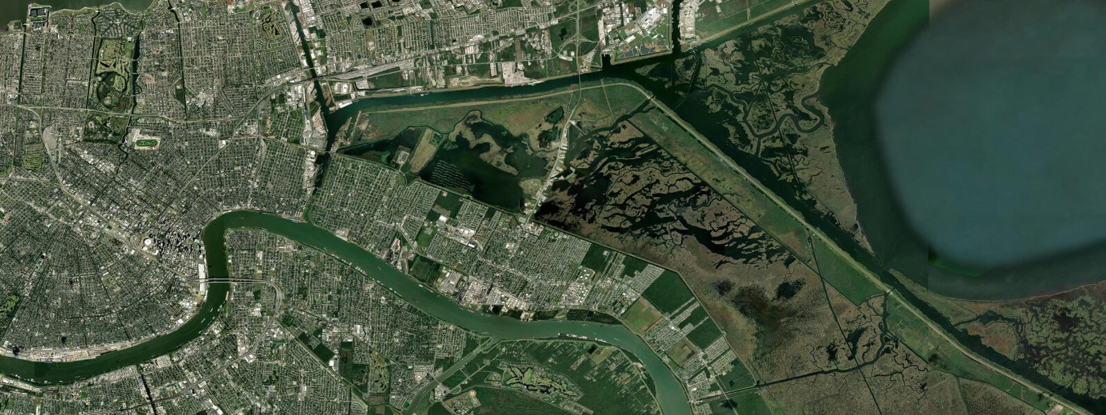
New Orleans sits on the Mississippi River delta about 160 kilometres upstream from the river's mouth at the Gulf of Mexico, the working port that handles the bulk of the inland-American grain and petrochemical exports through the Mississippi River navigation channel. The city is below sea level for most of its developed footprint — the levees on the east bank of the river run to about 5 metres above sea level at the Vieux Carré, and the back-of-town flat between the river and Lake Pontchartrain on the north sits 2 to 3 metres below sea level. The tide here is the Gulf of Mexico diurnal signal modulated heavily by river discharge and meteorological forcing.
4 metres at the Head of Passes; at the New Orleans waterfront the river-stage variation from upstream snowmelt-and-rainfall flow dominates anything astronomical, with a typical seasonal range of 4 to 5 metres at the Carrollton gauge from low water in autumn to the spring crest in March or April. Most days produce one clear high and one clear low rather than the two-and-two semidiurnal pattern; a smaller secondary excursion shows up at certain lunar phases but rarely matters for working planning. The defining historical event is Hurricane Katrina on 29 August 2005.
5-billion-dollar levee and floodwall network that the US Army Corps of Engineers built between 2007 and 2018. The defining working feature is the dredging programme. The Mississippi River below New Orleans is dredged to a 15-metre channel depth at the Southwest Pass to allow Panamax and post-Panamax vessels through to the Port of New Orleans, the Port of South Louisiana, and Baton Rouge upstream.
Working tugs, river pilots, the steamboats Natchez and City of New Orleans, the casino riverboats, and the long oyster fleet out of Plaquemines Parish below the city all read the river-stage forecast and the surge forecast more than the astronomical tide. NOAA CO-OPS runs the authoritative gauge network on the river and the Gulf approaches; the National Hurricane Center is the authoritative real-time source during tropical landfall events.
Tide questions about New Orleans, LA
Quick answers to the most common questions about tide times, range, and water access at New Orleans, LA.
When is the next high tide at New Orleans?
The hero block shows the next high tide at the city-front gauge in local Central time (CST/CDT with DST). The 7-day table covers daily highs and lows. The diurnal Gulf pattern means most days produce one clear high and one clear low; the river-stage variation from upstream flow typically dominates anything astronomical at the Carrollton waterfront.
What's the typical tide range at New Orleans?
The astronomical signal at New Orleans is small — about 0.4 metres mean range at the river mouth Head of Passes, smaller still at the city waterfront. The river-stage variation from upstream Mississippi flow runs 4 to 5 metres seasonally at the Carrollton gauge from low water in autumn to the spring crest in March or April, and dominates the day-to-day water level at the city. Hurricane storm surge can stack 4 to 7 metres above the astronomical signal during a tropical landfall event.
Where do these tide predictions come from?
Open-Meteo Marine, a gridded global ocean model. Useful for the river-mouth Gulf signal at Head of Passes and the diurnal pattern in the brackish lower delta. For the city-front river-stage forecast that actually matters at the Carrollton waterfront, the National Weather Service Lower Mississippi River Forecast Center is the authoritative source. NOAA CO-OPS runs the gauge network on the Gulf approaches.
How does Hurricane Katrina and the post-Katrina HSDRRS levee system shape the modern working coast?
Katrina drove the storm surge through the Mississippi River-Gulf Outlet navigation channel and the Lake Pontchartrain levee breaches that flooded about 80% of the city on 29 August 2005. The federal Greater New Orleans Hurricane and Storm Damage Risk Reduction System (HSDRRS) — the 230-kilometre, 14.5-billion-dollar US Army Corps of Engineers project built between 2007 and 2018 — wraps the city with new levees, surge barriers at the inland navigation canals, and the Lake Borgne Surge Barrier that closes off the eastern flank during a tropical event. The system is the largest civil-works project in US history outside the Panama Canal, and the modern working coast plans around its design-storm capacity.
Is this safe to use for navigation?
No. For piloting on the Mississippi River below New Orleans, the Southwest Pass dredged channel, or the Lake Pontchartrain crossings use the NOAA CO-OPS authoritative gauge readings, the National Weather Service Lower Mississippi River Forecast Center river-stage products, the Crescent River Port Pilots Association pilotage guidance, and the National Hurricane Center storm-surge warnings during tropical events. The river-stage variation and the surge potential dominate the planning calendar for any working transit.
0-day tide table — New Orleans, LA
Heights relative to MSL. Predictions: Open-Meteo Marine (MeteoFrance SMOC, 0.08° grid) — heights relative to MSL (not chart datum / LAT). Model-derived.
| Day | Type | Time | Height |
|---|