Keelung tide times
Keelung tide forecast — heights relative to MSL.
Today's tide times for Keelung
Tide times at Keelung on Sunday, 21 June 2026: first low tide at 09:15am, first high tide at 02:06pm, second low tide at 08:20pm. Sunrise 05:03am, sunset 06:45pm.
Tide chart for Keelung
24-hour cosine-interpolated curve around the present moment. Heights relative to MSL. Predictions: Predictions: Open-Meteo Marine (MeteoFrance SMOC, 0.08° grid).
Sun, moon and conditions on Sun 21 Jun
Snapshot at build time — refreshes daily. Sea state from Open-Meteo Marine.
Highs and lows next 7 days
Every predicted high and low for the next week, with the daily tidal coefficient (0–120; higher = bigger swing, > 95 means stronger currents).
Other spots nearby
The three closest curated TideTurtle locations to Keelung, measured by great-circle distance.
Today's solunar windows
Solunar tradition: major periods are the ≈3h windows around moon transit and opposition; minor are ≈2h around moonrise and moonset. Pair with the local tide stage and wind for the best read.
Cycle dates near Keelung
Next spring tide on Fri 26 Jun (range 0.8m). Next neap on Mon 22 Jun.
Spring tides cluster around new and full moons (biggest swings). Neap tides land on quarter moons (smallest swings). See the spring tide and neap tide glossary entries for the why.
About tides at Keelung
A short guide to the coastline at Keelung — geography, sea state, and what the tide is actually doing under your feet.
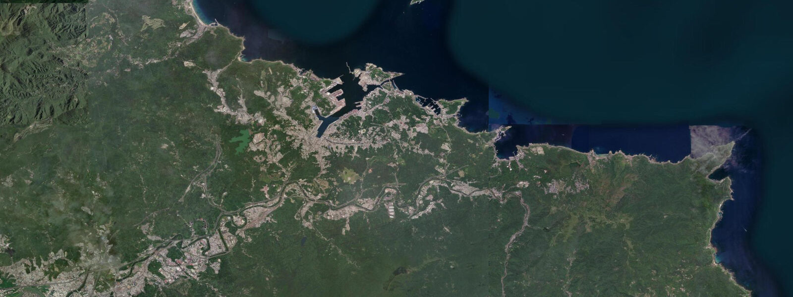
Keelung is Taiwan's second port city, built around one of the best natural harbours on the island's northeast coast. Steep, forested hills enclose the harbour on three sides; the narrow bay mouth faces east-northeast into the Pacific. 0 m relative to Chart Datum.
Spring tides at new and full moons push the higher high waters toward the top of that range; neap tides compress the cycle and reduce the height difference between the two daily highs. Tidal currents at the harbour entrance run noticeably in the constricted bay mouth on mid-tide ebb and flood, relevant for vessels manoeuvring in the approaches. Heping Island (Hoping Island), reached by bridge from the northern side of the city, holds the most photographed intertidal geology in northern Taiwan.
The basalt coastline has been eroded by wave and chemical weathering into a mosaic of uniform rectangular blocks — the 'tofu rock' formation — exposed fully at low water. The forms are best visited on a spring-tide low water when the maximum extent of the platform is accessible. Access to the Heping Island Park coastal trails is free; the geology interpretation centre has a small admission charge.
The Miaokou Night Market is the city's cultural centrepiece — a dense cluster of hawker stalls in the streets above the Keelung River near the harbour, operating every evening. The river itself drains to the inner harbour and its level responds to tidal backwater on the flood, occasionally complicating drainage in heavy rain combined with a high spring tide. Keelung is the northern terminus for Taiwan Railways Authority coastal services and is 30 minutes from Taipei by train or expressway.
3 m on height.
Tide questions about Keelung
Quick answers to the most common questions about tide times, range, and water access at Keelung.
What is the tidal range at Keelung?
Mean tidal range at Keelung is approximately 1.5 to 2.0 m relative to Chart Datum — mixed semidiurnal, with two highs and two lows per day of unequal height. Spring tides at new and full moons push toward the higher end of the range; neap tides can halve the height difference between consecutive high waters. The northwest Pacific mixed-semidiurnal signature means the tidal curve at Keelung looks markedly different from a simple European semidiurnal, with a pronounced diurnal inequality.
When is the best time to visit the Heping Island tofu rock formation?
At low water, particularly on a spring-tide day (within three days of new or full moon). The intertidal basalt platform — eroded into the distinctive rectangular 'tofu rock' blocks — is fully accessible only when the tide is out. On a neap-tide day the water may not drop far enough to fully expose the lower platform sections. Check the CWA tide table for the day before visiting Heping Island Park, and arrive about 30 minutes after predicted low water to allow the platform to drain.
How does the tide affect the Keelung River in heavy rain?
The Keelung River drains through the city to the inner harbour and its water level is subject to tidal backwater effects on the flood — particularly on spring high tides, when the harbour water level rises to within the river channel's drainage gradient. When heavy typhoon-season rain coincides with a spring high tide, the combination elevates flood risk in low-lying areas along the river. The city has floodgates and drainage infrastructure to manage this, but the CWA issues water-level warnings for the Keelung River during typhoon events.
Is Keelung worth visiting as a day trip from Taipei?
Yes. Keelung is 30 minutes from Taipei Main Station by Taiwan Railways Authority (TRA) train or by freeway. The Miaokou Night Market is one of the most concentrated and authentic hawker food experiences in northern Taiwan; the Heping Island Park coastal geology is genuinely distinctive; and the harbour itself is worth a walk for the contrast between the working container port and the wooded hills above. Low-water morning visits to Heping Island followed by an evening session at Miaokou makes a full day.
Are tide predictions for Keelung guaranteed to be accurate?
No prediction is guaranteed. Data on this page comes from Open-Meteo Marine modelling (typical accuracy ±45 minutes on timing, ±0.2–0.3 m on height) and is intended as planning guidance only. The Central Weather Administration (CWA) is the authoritative source for tidal predictions in Taiwan. Always verify with CWA before any activity where tidal state affects safety — particularly on the exposed Heping Island coastal platform, where wave wash over intertidal rocks can occur unexpectedly even at lower tide levels in a swell. This site does not accept responsibility for decisions made based on these predictions.
8-day tide table — Keelung
Heights relative to MSL. Predictions: Open-Meteo Marine (MeteoFrance SMOC, 0.08° grid) — heights relative to MSL (not chart datum / LAT). Model-derived.
| Day | Type | Time | Height |
|---|---|---|---|
| Sun 21 Jun | Low | 09:15 | 0.4m |
| High | 14:06 | 0.7m | |
| Low | 20:20 | 0.2m | |
| Mon 22 Jun | High | 03:21 | 0.9m |
| Low | 10:15 | 0.3m | |
| High | 16:10 | 0.7m | |
| Low | 21:42 | 0.4m | |
| Tue 23 Jun | High | 04:00 | 0.9m |
| Wed 24 Jun | Low | 11:40 | 0.2m |
| High | 18:54 | 0.9m | |
| Thu 25 Jun | Low | 00:10 | 0.7m |
| High | 19:45 | 0.9m | |
| Fri 26 Jun | Low | 13:04 | 0.1m |
| High | 20:54 | 0.9m | |
| Sat 27 Jun | Low | 13:21 | 0.1m |
| Sun 28 Jun | High | 06:00 | 0.7m |