Puerto La Cruz tide times
Puerto La Cruz tide forecast — heights relative to MSL.
Tide chart for Puerto La Cruz
24-hour cosine-interpolated curve around the present moment. Heights relative to MSL. Predictions: Predictions: Open-Meteo Marine (MeteoFrance SMOC, 0.08° grid).
Sun, moon and conditions on Sat 27 Jun
Snapshot at build time — refreshes daily. Sea state from Open-Meteo Marine.
Highs and lows next 7 days
Every predicted high and low for the next week, with the daily tidal coefficient (0–120; higher = bigger swing, > 95 means stronger currents).
Other spots nearby
The three closest curated TideTurtle locations to Puerto La Cruz, measured by great-circle distance.
Today's solunar windows
Solunar tradition: major periods are the ≈3h windows around moon transit and opposition; minor are ≈2h around moonrise and moonset. Pair with the local tide stage and wind for the best read.
About tides at Puerto La Cruz
A short guide to the coastline at Puerto La Cruz — geography, sea state, and what the tide is actually doing under your feet.
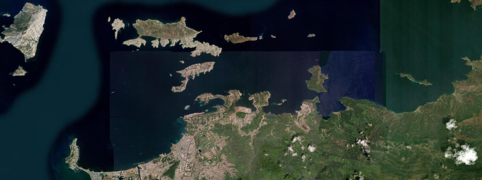
Puerto La Cruz is Venezuela's most important oil-related port and one of the Caribbean's busiest yacht anchorages, sitting in Anzoátegui state on the northeastern Caribbean coast. The city of 300,000 wraps around a protected bay facing the offshore islands of the Mochima National Park archipelago — a cluster of 30-plus small islands, coves, and beaches accessible only by boat, extending east from Puerto La Cruz toward Cumaná. The industrial infrastructure of the PDVSA oil terminal at El Chaure sits west of the main city; the eastern side of Puerto La Cruz Bay has the yacht marina and ferry terminal for Margarita Island. These two worlds — oil port and cruising destination — occupy the same geographic space and share the same harbour.
The tidal regime at Puerto La Cruz is microtidal: mixed semidiurnal with a spring range of 0.3–0.4 m above Chart Datum. The same eastern Caribbean trade-wind-dominated water-level pattern applies here as along Venezuela's entire coast. Mean high water springs sits at approximately 0.2–0.3 m above Chart Datum; mean low water springs is near 0.0 m. The harbour is sheltered enough that even the minor Caribbean swell is filtered by the island chain offshore; sea state inside the bay is typically flat unless a norther or tropical system is passing.
For cruising sailors and motor-yacht operators, Puerto La Cruz is the primary provisioning and clearance port on the Venezuelan coast. The Club Náutico de Puerto La Cruz marina and the adjacent anchorage in the bay hold several hundred boats during peak season (December–April). The 0.3–0.4 m tidal range is irrelevant for marina operations — berths are designed for far larger tidal ranges than the Caribbean delivers. The fuel dock operates at all tidal stages; vessel draft limitations at the marina entrance are governed by dredged depth, not tidal state. Navigation through the Mochima island chain requires attention to chart depths, but the small tidal range means the prudent charts-and-depth-sounder approach is sufficient without elaborate tidal calculation.
Mochima National Park is the primary attraction for day-trippers and overnight boaters from Puerto La Cruz. The park protects the coastal waters, islands, and reefs between Puerto La Cruz and Cumaná — roughly 94,935 hectares of Caribbean reef, mangrove, and coral lagoon. Lanchas (water taxis) from the Puerto La Cruz waterfront ferry passengers to the park's beaches for around 45 minutes' travel. The beaches at Isla Chimana Grande and Playa Arapito are the most visited; their sand is white coral sand and the water clarity is high given the distance from the port's industrial activities. Snorkelling on the reef patches around the outer islands is productive at all tidal stages — the 0.3–0.4 m range does not significantly change reef exposure in this area, though the shallowest reef crests dry briefly at low spring water.
Fishing in and around Puerto La Cruz is substantial. The offshore zone beyond the island chain targets tuna, wahoo, and mahi-mahi on the colour changes between the coastal green water and the blue water of the open Caribbean. Inside the island chain, the mangrove-edge habitat of the Mochima estuary system produces snook, tarpon, and juvenile snapper on the flooding tide — the same pattern as mangrove fisheries throughout the Caribbean. Lanchas and fishing charter operators can be arranged from the Club Náutico waterfront.
For anglers specifically targeting tarpon, the mangrove channels inside Mochima park are the operative environment. Tarpon cruise the mangrove edges on the incoming flood, feeding in water that is often less than 1.0 m deep on the flat areas between the mangroves and the outer reef. The narrow tidal range means the fish are not pushed far onto the flat, but the channels themselves provide ambush points where tarpon hold in the current break. Dawn on a spring flood is the standard approach from local guides.
Photographers based in Puerto La Cruz have two primary environments: the industrial dock culture of the oil-port waterfront (PDVSA terminal, supply vessels, the working harbour at sunset), and the natural island scenery of Mochima — clear water, white-sand beaches, rocky headlands, and the mangrove channels at low water when the root structure is exposed above the waterline. The mangrove image — roots arching into still, green water at morning low tide — requires the small ebb at low spring to expose the root bases fully.
All tide predictions for Puerto La Cruz come from the Open-Meteo Marine gridded model. Timing accuracy is ±45 minutes; height accuracy is ±0.3 m above Chart Datum.
Tide questions about Puerto La Cruz
Quick answers to the most common questions about tide times, range, and water access at Puerto La Cruz.
Is Puerto La Cruz a good base for exploring Mochima National Park by boat?
Puerto La Cruz is the primary access point for Mochima National Park. Lanchas (water taxis) depart the waterfront throughout the morning for the park's beaches and islands, taking 30–60 minutes depending on destination. The Club Náutico marina provides berths for private vessels and arranges charter boats for day trips and multi-day Mochima cruises. The 0.3–0.4 m tidal range does not create navigation constraints on the routes through the island chain in most conditions — chart depths and the depth sounder handle the approach safely. December through April is the calm season; June through November carries tropical weather risk.
What is the tidal range at Puerto La Cruz and how does it affect marina operations?
Puerto La Cruz has a mixed semidiurnal spring tidal range of 0.3–0.4 m. This is essentially irrelevant for marina operations — the Club Náutico berths and the fuel dock function without tidal constraint at any vessel draft the marina accepts. Navigation in the Mochima island chain requires attention to charted depths rather than tidal state, given the small range. Vessels should consult current Venezuelan charts for the inner passages; some channels between islands have 1.5–2.0 m minimum depth that demands attention for deeper-keel sailing yachts.
When is tarpon fishing productive in the Mochima mangrove channels?
Tarpon in the Mochima mangrove channels are most active on the incoming flood tide, when they cruise the mangrove edges feeding on mullet and other baitfish pushed by rising water into the channel margins. Dawn spring-flood conditions — when the tide is at its highest push and light is low — produce the most reliable activity. The narrow tidal range (0.3–0.4 m) means the flood doesn't push fish far onto the flats compared to higher-range fisheries, so the channel edges and current breaks are the productive positions. Local guides know the specific spots; arrange through the Club Náutico or the lancha operators on the waterfront.
What snorkelling is available in the Mochima park and does the tide affect reef access?
The reef patches around the outer islands of Mochima National Park — particularly around Isla Chimana Grande and the smaller cays east of Puerto La Cruz — have good coral coverage and fish density, with visibility typically 8–15 m in calm conditions. The shallowest reef crests dry very briefly at low spring tide (spring range 0.3–0.4 m), but this is a minor constraint. Most snorkel sites have 0.5–1.5 m of water over the reef at all tidal stages. The best snorkelling is on calm mornings before the afternoon trade wind builds; tidal state matters less than wind and weather for water clarity and comfortable surface conditions.
How does the Venezuela Coastal Current affect offshore fishing from Puerto La Cruz?
The Venezuela Coastal Current runs westward along the coast at 0.5–1.0 knots, creating a persistent flow that charter boats work by trolling across the current rather than with it. The current produces a colour change between green inshore water and blue offshore water at the 100–200 m depth contour east and northeast of Puerto La Cruz. Wahoo, mahi-mahi, and yellowfin tuna hold on this colour line. The upwelling zone off eastern Anzoátegui state intensifies during the November–March trade wind season, producing the year's best offshore conditions. Tidal phase has minimal influence on this offshore fishery; weather and current structure govern the day.
7-day tide table — Puerto La Cruz
Heights relative to MSL. Predictions: Open-Meteo Marine (MeteoFrance SMOC, 0.08° grid) — heights relative to MSL (not chart datum / LAT). Model-derived.
| Day | Type | Time | Height |
|---|---|---|---|
| Sat 27 Jun | — | ||
| Sun 28 Jun | Low | 08:15 | -0.4m |
| Mon 29 Jun | — | ||
| Tue 30 Jun | High | 00:15 | 0.1m |
| Low | 09:45 | -0.3m | |
| Wed 01 Jul | High | 00:50 | 0.1m |
| Low | 10:10 | -0.3m | |
| Thu 02 Jul | — | ||
| Fri 03 Jul | High | 02:00 | 0.1m |
| Low | 11:00 | -0.3m | |
| High | 19:00 | -0.1m | |