Morrocoy, Venezuela tide times
Morrocoy, Venezuela tide forecast — heights relative to MSL.
Tide chart for Morrocoy, Venezuela
24-hour cosine-interpolated curve around the present moment. Heights relative to MSL. Predictions: Predictions: Open-Meteo Marine (MeteoFrance SMOC, 0.08° grid).
Sun, moon and conditions on Sat 04 Jul
Snapshot at build time — refreshes daily. Sea state from Open-Meteo Marine.
Highs and lows next 7 days
Every predicted high and low for the next week, with the daily tidal coefficient (0–120; higher = bigger swing, > 95 means stronger currents).
Other spots nearby
The three closest curated TideTurtle locations to Morrocoy, Venezuela, measured by great-circle distance.
Today's solunar windows
Solunar tradition: major periods are the ≈3h windows around moon transit and opposition; minor are ≈2h around moonrise and moonset. Pair with the local tide stage and wind for the best read.
About tides at Morrocoy, Venezuela
A short guide to the coastline at Morrocoy, Venezuela — geography, sea state, and what the tide is actually doing under your feet.
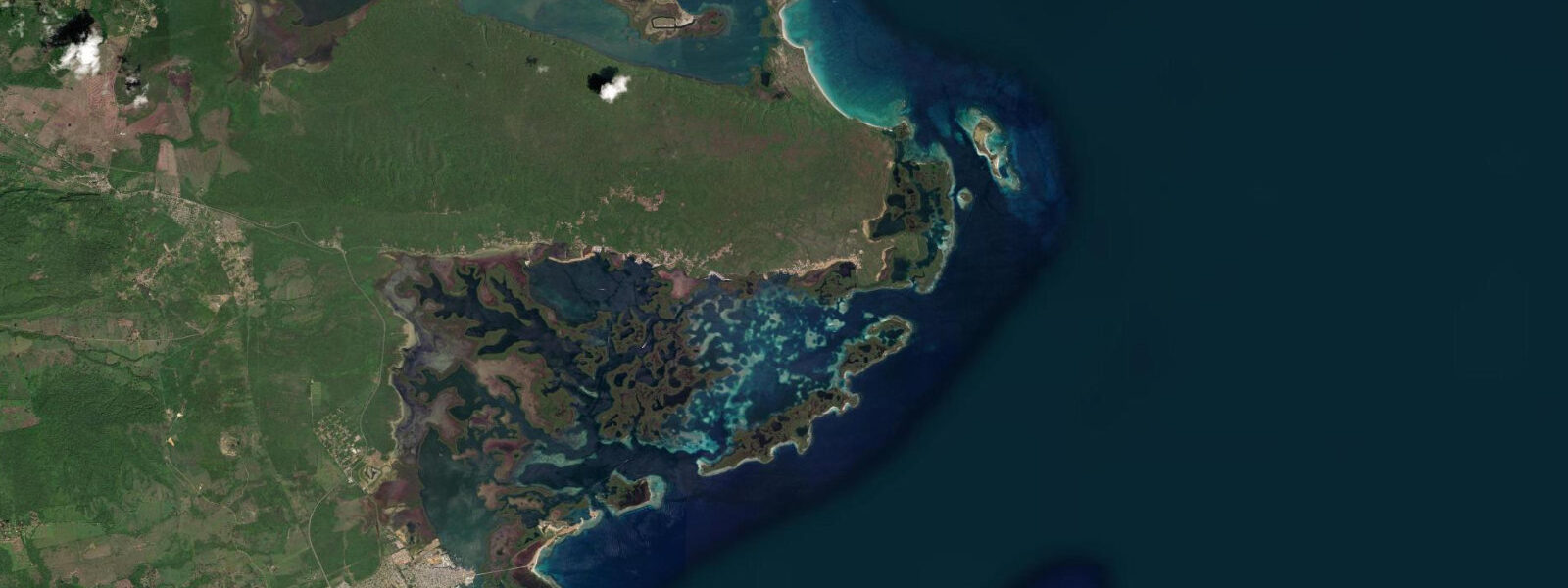
Morrocoy National Park protects a shallow cay system on Venezuela's central Caribbean coast, between the fishing town of Tucacas and the Cuare Wildlife Refuge at the lagoon's western end. The park is a mix of low mangrove cays, sandy beach islets, and shallow turquoise water over carbonate sand — the colour resembling the Turks and Caicos without the barrier reef. Boat access is the only way to reach the outer cays; launches depart from Tucacas's town dock.
The tidal regime at Morrocoy is Caribbean microtidal: mean range 0.3 to 0.4 metres, mixed semidiurnal. The park's shallow water and the sheltering effect of the cay system produce a very calm inshore environment; swell energy is almost entirely absorbed before reaching the inner cays. The principal water-level variable in the shallow inner passages is wind direction — a sustained easterly trade pushes water west toward the Cuare lagoon, and a calm spell allows the water to drop back. The 0.3 to 0.4 m tidal range produces detectable current through the cay passages on the flood and ebb, but the passages are shallow enough that even the ebb tide rarely drops them below knee depth.
The cays most frequently visited from Tucacas are Cayo Sombrero, Cayo Borracho, and Cayo Pelón. Sombrero is the largest and most developed, with beach chairs and basic food service; Borracho and Pelón are smaller, drier, and quieter. The snorkelling between the cays is on patch reefs in 2 to 5 m of water — brain coral, sea fans, cushion starfish on the sandy patches, and the usual Caribbean community of parrotfish, grunt, and damselfish. Visibility is best after several days of calm wind with no rain on the mainland; post-rain riverine discharge from the Aroa River to the east can reduce the bay clarity significantly.
Flamingos are the signature wildlife at Cuare Wildlife Refuge, on the western edge of the park complex adjacent to the Cuare lagoon. The flamingo population here is one of the largest accessible from Venezuela's north coast; birds are present year-round but concentrations are highest November through March during the dry season. Boat access through the mangrove channels to the lagoon interior reveals the full flamingo flats in the early morning, before wind and boat traffic disturb the birds.
Anglers fishing Morrocoy's cay system target snapper, grouper, and bonefish on the flats between cays. The inner lagoon flats nearest the Cuare mouth are the primary bonefish habitat; the fish move onto the shallow flats in the first two hours of the incoming tide and retreat to the channel edges as the ebb advances. Light fly tackle or spinning gear with a small jig produces consistent results on the bonefish; snapper work the channel edges at deeper stations throughout the tide cycle.
Families from Caracas and Valencia use Morrocoy as the primary day-trip and weekend Caribbean destination for the western Caracas urban area — it is 3 hours from Caracas, 2 from Valencia. Weekend boat traffic between cays is heavy from November through April (dry season); midweek and May through October are quieter. The cays are at their most relaxed on weekday mornings in the off-peak season, when only a few other launches are on the water.
Photographers targeting the flamingo flats need to be in a boat before dawn, positioned downwind of the flock, and shooting with a long lens by first light. The reflection photography in the shallow still water of the lagoon in calm conditions is the signature image of the Cuare section. Above the cays, the colour gradation from white sand through turquoise shallows to deep blue channel is most visible from altitude — drone regulations in Venezuelan national parks require permits.
Predictions on this page come from Open-Meteo Marine, a global gridded ocean model. Accuracy is ±45 minutes on timing and ±0.2 to 0.3 metres on height. INAMEH is the authoritative tidal reference for Venezuela.
Tide questions about Morrocoy, Venezuela
Quick answers to the most common questions about tide times, range, and water access at Morrocoy, Venezuela.
When is the next high tide at Morrocoy?
The predicted next high tide at Morrocoy is shown at the top of this page in Venezuela Standard Time (VET, UTC-4). Spring range is 0.3 to 0.4 metres — microtidal Caribbean. Wind direction dominates short-term water-level variation in the shallow cay system more than the astronomical tide; a sustained easterly trade pushes water into the inner lagoon and a calm spell allows it to drop back. Predictions come from Open-Meteo Marine (gridded, ±45 min / ±0.2–0.3 m). INAMEH and the Armada Venezolana Hydrographic Service are the authoritative tidal references for Venezuelan waters.
How do you reach the cays at Morrocoy?
The cays are accessible only by boat from Tucacas town dock, about 180 km west of Caracas on Route 1. Launches (lanchas) for hire are available from the dock from early morning; typical one-way crossing to Cayo Sombrero is 15–20 minutes. Day-trip fares include pickup at day's end. Bring your own food, water, and shade equipment for the outer cays — Cayo Sombrero has basic vendors but the smaller cays have nothing.
When is the best time to see flamingos at Cuare?
Flamingos are present at Cuare Wildlife Refuge year-round but concentrations peak November through March in the dry season. Early morning boat trips into the mangrove channels, before wind and boat activity disturb the birds, give the best sightings. The flamingos feed on algal mats in the shallow lagoon; they are most active at low light, in the hours around sunrise. Ask Tucacas launch operators for current flock location — it shifts within the lagoon seasonally.
Is snorkelling good at Morrocoy?
Snorkelling at Morrocoy is on patch reefs in 2–5 m between the cays. Visibility is strongly condition-dependent — best after calm weather with no recent mainland rain, worst after riverine discharge from the east. The reefs are not pristine compared to the outer Caribbean reef systems, but they are accessible, the fish diversity is reasonable, and the setting in turquoise shallow water surrounded by mangrove and sandy islets is attractive. The slack near the predicted tide change gives the calmest current in the inter-cay passages.
Is this safe to use for navigation?
No. TideTurtle is a planning tool, not a nautical almanac. Navigation through the Morrocoy cay system requires knowledge of the shallow passages and current charts — several channels dry at low water and the bar at the Tucacas dock entrance is shallow. Local launch operators navigate these waters daily and their guidance is the most current reference. Open-Meteo Marine predictions are not a substitute for authoritative harmonic data for any vessel operation.
5-day tide table — Morrocoy, Venezuela
Heights relative to MSL. Predictions: Open-Meteo Marine (MeteoFrance SMOC, 0.08° grid) — heights relative to MSL (not chart datum / LAT). Model-derived.
| Day | Type | Time | Height |
|---|---|---|---|
| Sat 04 Jul | — | ||
| Sun 05 Jul | Low | 11:00 | -0.2m |
| High | 18:00 | 0.0m | |
| Mon 06 Jul | Low | 10:50 | -0.2m |
| Tue 07 Jul | — | ||
| Wed 08 Jul | High | 20:00 | 0.2m |