Corpus Christi, Texas tide times
Corpus Christi, Texas tide forecast — heights relative to MSL.
Today's tide times for Corpus Christi, Texas
Tide times at Corpus Christi, Texas on Friday, 19 June 2026: first high tide at 05:00pm. Sunrise 06:33am, sunset 08:27pm.
Tide chart for Corpus Christi, Texas
24-hour cosine-interpolated curve around the present moment. Heights relative to MSL. Predictions: Predictions: Open-Meteo Marine (MeteoFrance SMOC, 0.08° grid).
Sun, moon and conditions on Fri 19 Jun
Snapshot at build time — refreshes daily. Sea state from Open-Meteo Marine.
Highs and lows next 7 days
Every predicted high and low for the next week, with the daily tidal coefficient (0–120; higher = bigger swing, > 95 means stronger currents).
Other spots nearby
The three closest curated TideTurtle locations to Corpus Christi, Texas, measured by great-circle distance.
Today's solunar windows
Solunar tradition: major periods are the ≈3h windows around moon transit and opposition; minor are ≈2h around moonrise and moonset. Pair with the local tide stage and wind for the best read.
About tides at Corpus Christi, Texas
A short guide to the coastline at Corpus Christi, Texas — geography, sea state, and what the tide is actually doing under your feet.
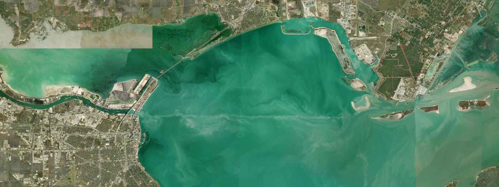
Corpus Christi sits along the arc of Corpus Christi Bay on the Texas Gulf Coast, separated from the open Gulf of Mexico by the long thin screens of Mustang Island and North Padre Island. The bay is shallow — averaging around 3 m — which means that even the modest tidal range produced by the Gulf of Mexico creates substantial horizontal water movement across the flats. The tidal pattern here is strongly diurnal: one high and one low per day, with the high typically arriving in the afternoon. Mean tidal range runs 0.3–0.5 m, small by global standards, but the geometry of the bay amplifies that vertical signal into meaningful current through the inlets and across the grass beds.
The Packery Channel is the engineered inlet between North Padre Island and Mustang Island, connecting Corpus Christi Bay directly to the Gulf. On a tidal exchange, the current through the channel runs 2–4 knots. For kayakers and paddleboarders, the channel is a one-way transit during the stronger exchanges — entering on the flood, exiting on the ebb, or staying well clear of the main channel and threading the calmer shallows alongside the jetties. Surfers use the south jetty at Packery Channel as a wave-focusing structure; the break works best on east or northeast swell with an outgoing tide.
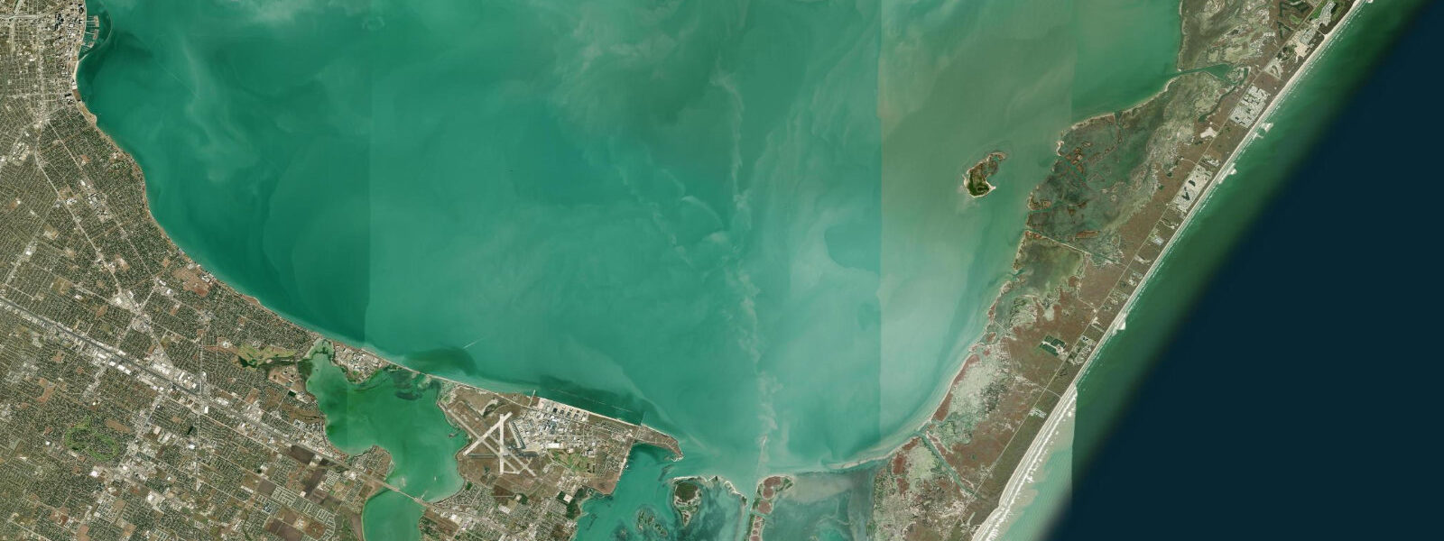
Behind the barrier islands lies the Laguna Madre, one of only five hypersaline lagoons in the world. Evaporation far outpaces freshwater input in this stretch of coast, pushing salinity well above open-ocean seawater levels. The result is a distinctive ecology: seagrass meadows of shoalgrass and widgeongrass carpet the shallows, supporting one of the densest populations of redhead ducks in North America during winter migration. The lagoon averages less than 1 m in depth across much of its width, which means tidal stage governs where a skiff can run and where it can't.
For anglers, the tidal flats of Corpus Christi Bay and the Laguna Madre are among the most productive inshore fisheries in the United States. Red drum — redfish locally — follow the flood tide onto the shallow grass flats, tailing in water barely deep enough to cover their backs. Speckled trout hold at the edges of deeper channels, moving shallow on the feed. Flounder sit in the cuts between flats and deeper water, ambushing baitfish pushed by the current. The windows are tight: fish the first two hours of the incoming tide on the flats, then reassess as the water peaks and the reds push off into deeper structure. A dropping tide concentrates fish in the channels, which is good for trout but requires a different approach entirely.
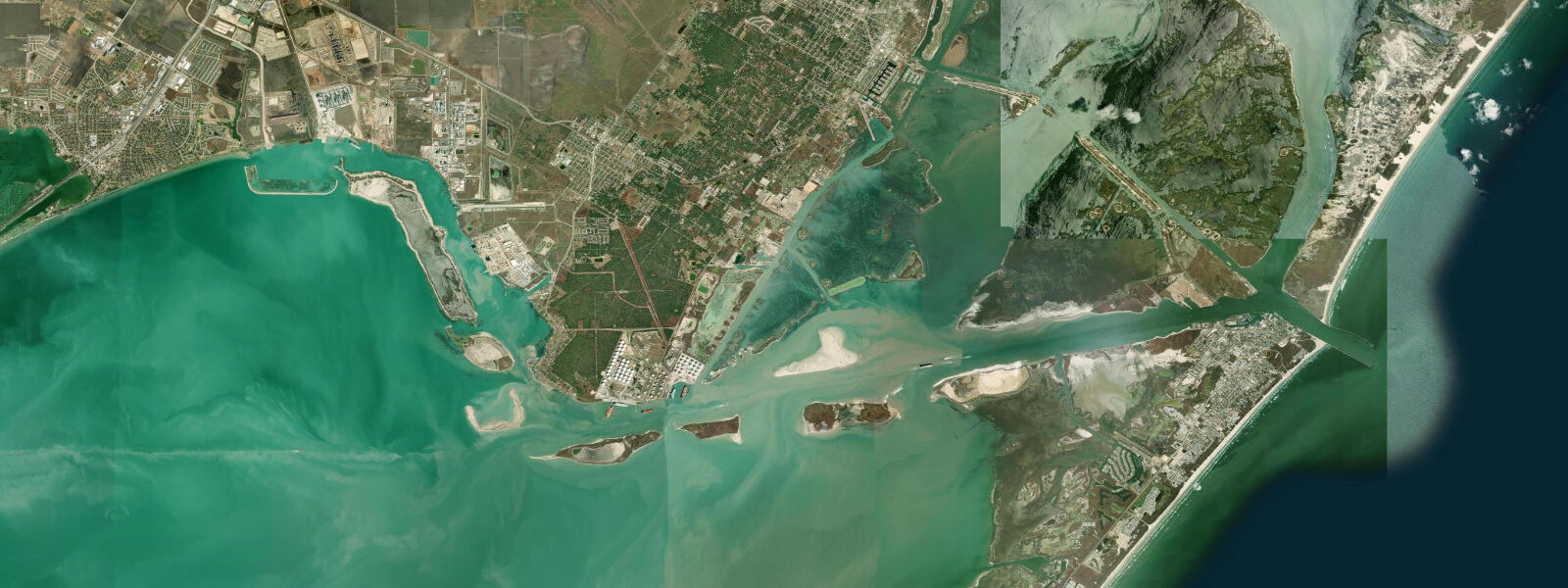
Padre Island National Seashore begins at the southern end of the Park Road 22 causeway from Corpus Christi and extends 113 km south — the longest undeveloped barrier island in the world. The park protects the Gulf shoreline, the back-bay Laguna Madre shoreline, and the grassland interior from development. Sea turtle nesting runs from late April through July, primarily Kemp's ridley turtles — the park hosts one of the most intensive sea turtle protection programs in the country, with night patrols during nesting season. Beachcombers and shell collectors work the waterline at low tide, when the retreating water exposes wet sand and concentrates what the waves have deposited.
Corpus Christi Bay hosts the USNS Lexington (CV-16), an Essex-class aircraft carrier decommissioned in 1991 and permanently moored as a naval aviation museum. The ship is 270 m long and sits at a fixed position regardless of tide — but the floating gangways that connect vessel to dock adjust with water level, and at low water the angle steepens noticeably.
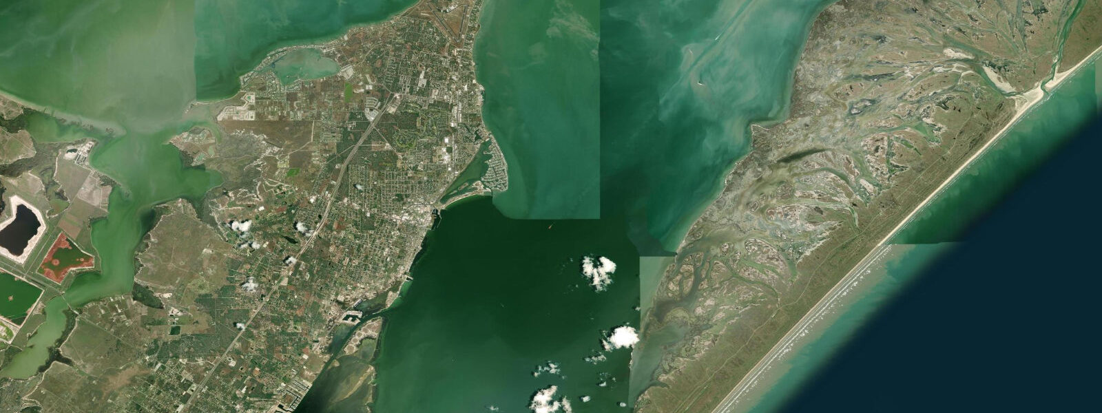
Photographers working the bay find the best light in the hour before sunset, with the Corpus Christi skyline to the northwest and the carrier visible in the middle distance. Shorebirds — willets, sanderlings, black-bellied plovers — concentrate on the tidal flats at low water, picking through exposed invertebrates. The reddish egret, one of the rarest herons in North America, is a regular here; it dances and spins while hunting in the shallows, using its wings to startle fish.
North and South Padre Islands are visible to the east from the bayfront. The ferry crossing from Port Aransas (north of Mustang Island) is tidal-sensitive for larger recreational vessels; smaller boats use Packery Channel. The city's bayfront parks and the seawall along Shoreline Boulevard provide direct access to the water without a boat — usable at any tide, though the beach exposure changes with water level.
Tide data for Corpus Christi, Texas comes from the Open-Meteo Marine API, a gridded model product. Timing accuracy is ±45 minutes, height accuracy ±0.3 m — usable for trip planning, not for navigation.
Tide questions about Corpus Christi, Texas
Quick answers to the most common questions about tide times, range, and water access at Corpus Christi, Texas.
What is the tidal pattern at Corpus Christi and how large is the range?
Corpus Christi experiences a strongly diurnal tidal pattern — one high tide and one low tide per day, rather than the two-cycle semidiurnal pattern common on the Atlantic or Pacific coasts. The mean tidal range is 0.3–0.5 m. That vertical figure is small, but the Laguna Madre and Corpus Christi Bay are extremely shallow, averaging around 1 m or less across much of the lagoon system. Even a 0.4 m change in water level shifts the shoreline substantially across the grass flats and can strand boats that run too shallow on a falling tide.
When is the best tide for fishing the flats around Corpus Christi?
The first two hours of an incoming tide on the shallow grass flats is the prime window for redfish. The flood pushes baitfish and crabs onto the flat and red drum follow, often tailing in water 30–40 cm deep where they are visible and approachable. Speckled trout hold at the channel edges throughout the tidal cycle but are most active on the moving water — either incoming or outgoing — rather than at slack. Flounder concentrate in the deeper cuts on the ebb, positioned to intercept baitfish swept off the flat by the falling water. Early morning or late afternoon low tides in autumn produce the best combined trout and flounder fishing.
Is the Packery Channel safe for kayaks and paddleboards?
Packery Channel can be paddled safely with tide awareness. The channel connects Corpus Christi Bay to the Gulf and carries 2–4 knot currents on a full tidal exchange, which is strong enough to push a kayak sideways and make upstream progress difficult. The safest strategy is to plan the channel transit to coincide with slack water — roughly 30 minutes either side of high or low — or to paddle with the current. The calm shallows alongside the jetties offer a lower-current route for inexperienced paddlers. Avoid the channel during strong south or southeast winds combined with an outgoing tide, which steepen wave height in the inlet.
When do sea turtles nest on Padre Island National Seashore?
Kemp's ridley sea turtles nest on Padre Island National Seashore from late April through mid-July, with peak nesting in May and June. The park runs a protection program that patrols beaches at night during the season, relocating eggs to a protected hatchery when necessary. Hatchling releases occur 45–55 days after nesting, typically June through early August. Green and loggerhead turtles also nest occasionally. Public hatchling releases are announced on the park website and draw large crowds — arrive at low to mid tide when the beach is widest and the walk to the waterline shortest.
Does the tide affect visiting the USNS Lexington museum ship?
The USNS Lexington (CV-16) is permanently moored in Corpus Christi Bay and is accessible at all tidal stages. The ship itself does not move with the tide. The floating gangways connecting the ship to the dock adjust to water level, so the angle of the boarding ramp changes — at low water (around mean low of 0.1 m above MLLW for this area) the ramp angle increases, which can be noticeable for visitors using mobility aids. Museum operations are not interrupted by tide. The best photography of the ship from the bayfront parks is at high water, when the waterline is higher and the reflection in the bay is cleaner.
7-day tide table — Corpus Christi, Texas
Heights relative to MSL. Predictions: Open-Meteo Marine (MeteoFrance SMOC, 0.08° grid) — heights relative to MSL (not chart datum / LAT). Model-derived.
| Day | Type | Time | Height |
|---|---|---|---|
| Fri 19 Jun | High | 17:00 | 0.1m / 0.2ft |
| Sat 20 Jun | Low | 00:54 | -0.3m / -1.0ft |
| Sun 21 Jun | High | 09:00 | 0.1m / 0.2ft |
| Mon 22 Jun | — | ||
| Tue 23 Jun | — | ||
| Wed 24 Jun | — | ||
| Thu 25 Jun | Low | 18:00 | -0.5m / -1.5ft |