Portsmouth, NH tide times
Portsmouth, NH tide forecast — heights relative to MSL.
Today's tide times for Portsmouth, NH
Tide times at Portsmouth, NH on Sunday, 21 June 2026: first high tide at 04:33am, first low tide at 10:44am, second high tide at 05:06pm, second low tide at 11:19pm. Sunrise 05:03am, sunset 08:25pm.
Tide chart for Portsmouth, NH
24-hour cosine-interpolated curve around the present moment. Heights relative to MSL. Predictions: Predictions: Open-Meteo Marine (MeteoFrance SMOC, 0.08° grid).
Sun, moon and conditions on Sun 21 Jun
Snapshot at build time — refreshes daily. Sea state from Open-Meteo Marine.
Highs and lows next 7 days
Every predicted high and low for the next week, with the daily tidal coefficient (0–120; higher = bigger swing, > 95 means stronger currents).
Other spots nearby
The three closest curated TideTurtle locations to Portsmouth, NH, measured by great-circle distance.


Today's solunar windows
Solunar tradition: major periods are the ≈3h windows around moon transit and opposition; minor are ≈2h around moonrise and moonset. Pair with the local tide stage and wind for the best read.
Cycle dates near Portsmouth, NH
Last spring tide on Sat 20 Jun (range 2.7m / 9.0ft). Next spring tide on Fri 26 Jun (range 2.6m / 8.6ft). Next neap on Wed 24 Jun.
Spring tides cluster around new and full moons (biggest swings). Neap tides land on quarter moons (smallest swings). See the spring tide and neap tide glossary entries for the why.
About tides at Portsmouth, NH
A short guide to the coastline at Portsmouth, NH — geography, sea state, and what the tide is actually doing under your feet.
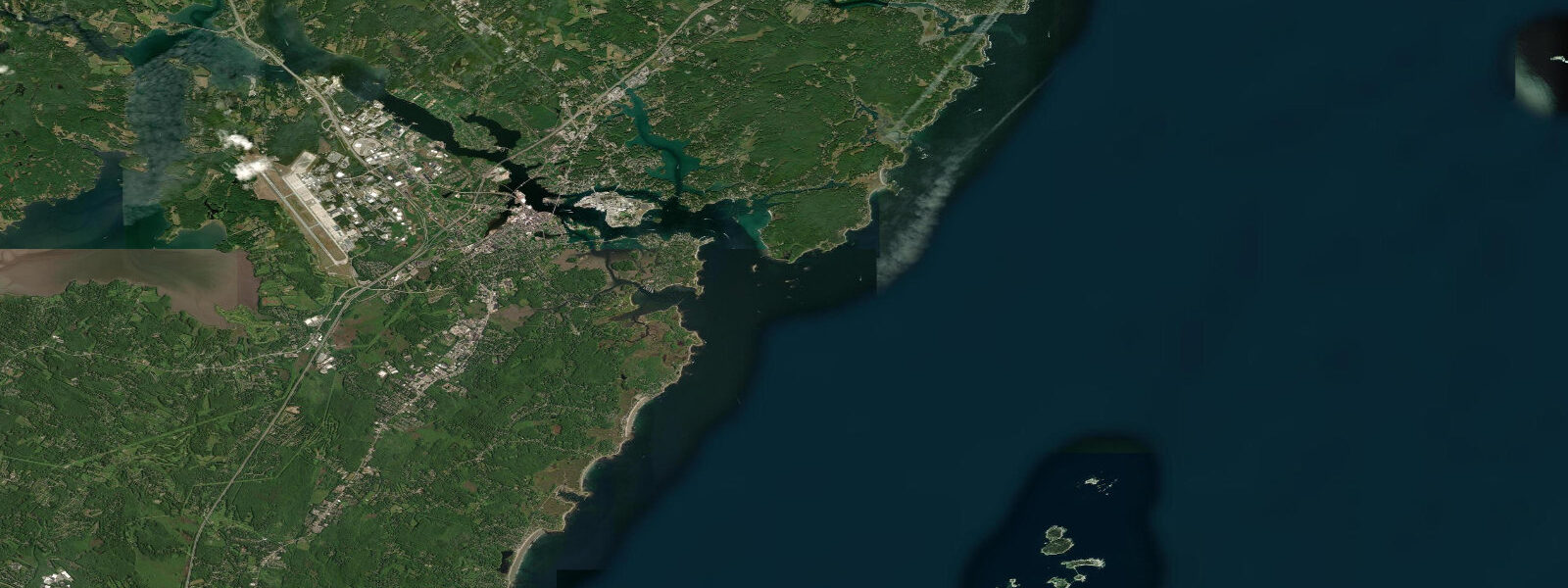
Portsmouth sits at the mouth of the Piscataqua River, the fast-running tidal waterway that forms the New Hampshire-Maine border from Great Bay Estuary to the open ocean. The tidal regime is semidiurnal — two high and two low tides per day — with a mean spring range around 2.6 metres MLLW at Portsmouth Harbor (station 8423898), fractionally less than the open Hampton Beach coast because the harbour geometry slightly modifies the tidal wave. But it is not the range that defines Portsmouth's tidal character — it is the current.
The Piscataqua River is one of the fastest tidal rivers in the eastern United States. The river drains Great Bay Estuary, a 4,000-hectare estuarine basin, through a relatively narrow channel that accelerates the tidal flow to regularly exceed 3 knots at the railroad bridge and in the main harbour approach. On large spring tides, peak current in the river approaches 4 knots — among the fastest documented tidal river velocities on the US Atlantic coast. The current reverses four times daily with the semidiurnal cycle, and the transition from flood to ebb or ebb to flood produces brief but chaotic tidal rip conditions at the river bends and at the harbour mouth near Fort Point.
Portsmouth Harbor Lighthouse stands on the southern tip of New Castle Island, at the point where the Piscataqua River meets the open harbour and the coastline of the Isles of Shoals becomes visible 10 kilometres offshore. The lighthouse, built in 1877, marks the edge of the harbour channel and the beginning of open water; the Wentworth Marina on New Castle Island and the tugboat moorings on the river bank reflect the working-harbour character that Portsmouth has maintained through its colonial, industrial, and maritime eras. The Portsmouth Naval Shipyard — technically on Seavey Island in Kittery, Maine, on the opposite bank — has operated continuously since 1800 and remains one of the oldest active shipyards in the US.
The historic Strawbery Banke Museum on Marcy Street preserves four centuries of Portsmouth waterfront history on a ten-acre site adjoining the Puddle Dock tidal inlet. The museum's interpretation spans from the 1630s settlement — Portsmouth was one of the earliest permanent European settlements in New England — through the 18th-century merchant trade, the 19th-century immigrant neighbourhoods, and the 20th-century preservation effort that saved the neighbourhood from urban renewal. The Puddle Dock itself was a tidal basin and working waterway until it was filled in the late 19th century; the museum's interpretation of tidal and maritime history is physically grounded in the site.
For kayakers and paddlers, the Piscataqua River current is the defining planning factor. Launching from Prescott Park or the Badger Island marina and paddling downstream on the ebb is straightforward; paddling upstream against the flood or running downstream against the ebb requires active ferry angles and knowledge of the eddy lines behind the bridge pilings. The harbour crossing to New Castle Island and the approach to the Isles of Shoals beyond require coordination with the commercial shipping and naval vessel traffic that uses the deep-water channel. The Isles of Shoals — a cluster of granite islands 10 km offshore — are a day-paddle or overnight destination for experienced sea kayakers on settled weather days, but the passage requires crossing the shipping lane in the outer harbour.
Predictions on this page come from Open-Meteo Marine, a global gridded ocean model. Accuracy is typically within plus or minus 45 minutes on timing and 0.2 to 0.3 metres on height — model-derived, not from the NOAA Portsmouth gauge. For authoritative US tidal data, NOAA CO-OPS Portsmouth Harbor (station 8423898) is a primary reference station and provides both height and current predictions for the harbour and the Piscataqua River.
Tide questions about Portsmouth, NH
Quick answers to the most common questions about tide times, range, and water access at Portsmouth, NH.
When is high tide at Portsmouth, NH?
The tide table on this page shows predicted times in Eastern Time (EST UTC-5, EDT UTC-4 in summer). Portsmouth Harbor runs two tidal cycles per day with mean spring range around 2.6 metres MLLW. Portsmouth Harbor (NOAA station 8423898) is a primary tidal reference station for the New Hampshire and southern Maine coast — the most accurate predictions for the harbour and the Piscataqua River come directly from NOAA CO-OPS at tidesandcurrents.noaa.gov. NOAA also publishes current predictions for the Piscataqua River separately from height predictions — both are relevant for navigation.
How fast is the tidal current in the Piscataqua River at Portsmouth?
The Piscataqua River is one of the fastest tidal rivers on the US Atlantic coast. Tidal current regularly exceeds 3 knots (about 5.5 km/h) at the railroad bridge and in the main harbour reach; on large spring tides, peak current approaches 4 knots. The current runs four cycles daily (two floods, two ebbs) and reverses quickly with limited slack time at the turning points. The fast current is driven by the large tidal volume draining Great Bay Estuary through the river's relatively narrow channel. NOAA publishes dedicated current predictions for the Piscataqua — use those for any water-based activity in the river.
Can I kayak on the Piscataqua River and Portsmouth Harbor?
Experienced sea kayakers paddle the harbour regularly, but the Piscataqua River demands careful planning. The fast current (up to 4 knots peak spring) means route planning around tidal timing is mandatory — paddling against peak current is not practical for most kayakers. Use NOAA's current predictions (not just height predictions) for the Piscataqua, and plan harbour crossings to New Castle Island during the brief slack period. The commercial shipping channel has active deep-draft vessel traffic; keep well to the edges and be visible. The outer harbour and Isles of Shoals crossing is advanced open-water paddling.
What is Strawbery Banke Museum in Portsmouth?
Strawbery Banke Museum is a ten-acre outdoor history museum at the Puddle Dock neighbourhood in downtown Portsmouth, preserving and interpreting 400 years of the waterfront neighbourhood's history from the 1630s European settlement through the 20th century. It is one of the most significant historic preservation sites in New England. The Puddle Dock was originally a tidal inlet used by colonial merchants; the museum's interpretation includes maritime trade, the tidal and river geography that shaped the settlement, and the architecture of successive immigrant communities. Open seasonally; some exhibit buildings are open year-round.
Is this tide data safe for navigation in Portsmouth Harbor?
No. Open-Meteo Marine gridded predictions are not a substitute for NOAA tidal data, current predictions, or nautical charts. Portsmouth Harbor has active commercial shipping traffic, the Naval Shipyard, and the Piscataqua River's fast tidal current — all of which require authoritative data sources for safe navigation. Use NOAA Chart 13283 (Portsmouth Harbor), NOAA CO-OPS height predictions for Portsmouth Harbor (station 8423898), and NOAA current predictions for the Piscataqua River. The Portsmouth Harbor Coast Pilot section (NOAA Coast Pilot Volume 1) provides current-by-current guidance for river transits.
7-day tide table — Portsmouth, NH
Heights relative to MSL. Predictions: Open-Meteo Marine (MeteoFrance SMOC, 0.08° grid) — heights relative to MSL (not chart datum / LAT). Model-derived.
| Day | Type | Time | Height |
|---|---|---|---|
| Sun 21 Jun | High | 04:33 | 0.9m / 3.1ft |
| Low | 10:44 | -1.8m / -5.9ft | |
| High | 17:06 | 0.9m / 3.0ft | |
| Low | 23:19 | -1.7m / -5.5ft | |
| Mon 22 Jun | High | 05:33 | 0.7m / 2.4ft |
| Low | 11:41 | -1.7m / -5.7ft | |
| High | 18:05 | 0.8m / 2.7ft | |
| Tue 23 Jun | Low | 00:21 | -1.5m / -5.1ft |
| High | 06:37 | 0.7m / 2.3ft | |
| Low | 12:43 | -1.6m / -5.2ft | |
| High | 19:01 | 0.8m / 2.7ft | |
| Wed 24 Jun | Low | 01:27 | -1.7m / -5.5ft |
| High | 07:37 | 0.5m / 1.7ft | |
| Low | 13:35 | -1.5m / -5.0ft | |
| High | 19:52 | 0.8m / 2.8ft | |
| Thu 25 Jun | Low | 02:18 | -1.7m / -5.4ft |
| High | 08:33 | 0.5m / 1.6ft | |
| Low | 14:31 | -1.5m / -4.8ft | |
| High | 20:47 | 0.8m / 2.7ft | |
| Fri 26 Jun | Low | 03:10 | -1.7m / -5.6ft |
| High | 21:35 | 0.9m / 3.0ft | |
| Sat 27 Jun | Low | 04:01 | -1.7m / -5.6ft |
| High | 10:18 | 0.5m / 1.7ft | |
| Low | 16:01 | -1.3m / -4.3ft | |
| High | 19:00 | -0.1m / -0.4ft |