
Fair Isle, Shetland tide times
Fair Isle, Shetland tide forecast — heights relative to MSL.
Today's tide times for Fair Isle, Shetland
Tide times at Fair Isle, Shetland on Saturday, 4 July 2026: first high tide at 01:00, first low tide at 07:44, second high tide at 14:02, second low tide at 19:22. Sunrise 03:55, sunset 22:24.
Tide chart for Fair Isle, Shetland
24-hour cosine-interpolated curve around the present moment. Heights relative to MSL. Predictions: Predictions: Open-Meteo Marine (MeteoFrance SMOC, 0.08° grid).
Sun, moon and conditions on Sat 04 Jul
Snapshot at build time — refreshes daily. Sea state from Open-Meteo Marine.
Highs and lows next 7 days
Every predicted high and low for the next week, with the daily tidal coefficient (0–120; higher = bigger swing, > 95 means stronger currents).
Other spots nearby
The three closest curated TideTurtle locations to Fair Isle, Shetland, measured by great-circle distance.
Today's solunar windows
Solunar tradition: major periods are the ≈3h windows around moon transit and opposition; minor are ≈2h around moonrise and moonset. Pair with the local tide stage and wind for the best read.
Cycle dates near Fair Isle, Shetland
Last spring tide on Sat 04 Jul (range 1.5m / 4.9ft). Next neap on Thu 09 Jul.
Spring tides cluster around new and full moons (biggest swings). Neap tides land on quarter moons (smallest swings). See the spring tide and neap tide glossary entries for the why.
About tides at Fair Isle, Shetland
A short guide to the coastline at Fair Isle, Shetland — geography, sea state, and what the tide is actually doing under your feet.
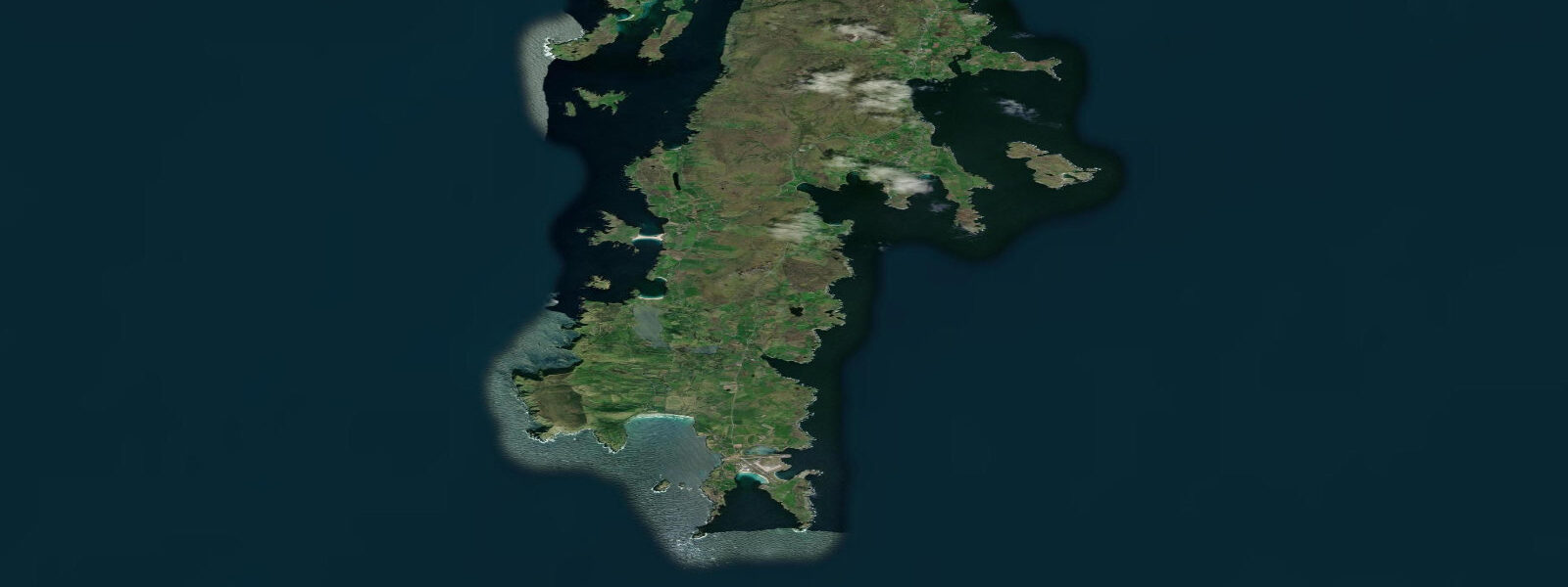
Fair Isle sits alone in the sea between Orkney and Shetland — 24 km from North Ronaldsay, the nearest Orkney island, and 38 km south of Sumburgh Head at the tip of the Shetland Mainland. It is one of the most remote permanently inhabited islands in the United Kingdom, home to around 55 people. The island is owned by the National Trust for Scotland and has been since 1954, when George Waterston — who founded the Bird Observatory — persuaded the NTS to purchase it from the estate.
The Fair Isle Bird Observatory is the island's primary institution. Opened in 1948, it is one of the oldest bird observatories in Britain and one of the most productive for rare vagrant records. The island's position at a crossing point for migratory birds travelling between Scandinavia and Britain makes it a concentration point during autumn migration — typically late August through October — when falls of migrants can bring dozens of rare species to the island in a single day. More than 370 species have been recorded on Fair Isle. Observatory accommodation is available by advance booking and fills months ahead for the peak autumn season.
The tidal environment around Fair Isle is demanding. Tides are semidiurnal with a mean spring range of approximately 1.5–2.0 m, typical for the Shetland area. The critical factor is the tidal stream: the island sits in one of the most tide-swept stretches of open sea in the British Isles, between the eddies and flows generated by the Pentland Firth to the south and the Shetland tidal system to the north. Streams around the headlands and through the gap between Fair Isle and the North Ronaldsay shoals run at 2–4 knots at springs, with higher velocities possible off the exposed northeastern tip in adverse conditions.
The Good Shepherd IV, the island's lifeline ferry, operates between Fair Isle and Grutness (Sumburgh, Shetland) roughly twice weekly in summer and once a week in winter, weather permitting. The crossing takes approximately 2.5 hours and the vessel uses North Harbour on the island's east side. South Harbour on the southwest tip is for small craft only — local fishing boats use it when conditions allow. Neither harbour is entirely sheltered in all wind directions, and the ferry has a significant cancellation rate in autumn and winter storms.
For wildlife beyond birds, Fair Isle's sea stacks and cliff base platforms hold one of the larger grey seal colonies in Shetland, with pupping from October to December. Minke whales are regular summer visitors offshore from June through August, and harbour porpoise are present year-round in the sounds around the island. The island's knitwear tradition — Fair Isle knitting, with its distinctive repeating geometric colour-band patterns — has protected geographical indication status and is produced by a small number of island families.
Access by air is via the Loganair service from Tingwall Airport near Lerwick, using a small aircraft running two or three times weekly weather permitting. Given the exposure of the island, cancelled flights and delayed ferries are a normal part of the rhythm rather than exceptional events. Any visit requires a generous buffer of days — plan for possible overnight extensions if arriving mid-week. The combination of remoteness, birdwatching quality, and the knitwear tradition makes Fair Isle one of the few truly distinctive island destinations in northern Scotland.
Tide predictions here use Open-Meteo Marine, a global gridded model. Timing accuracy is typically ±45 minutes; height accuracy typically ±0.2–0.3 m. For boat approaches to Fair Isle, treat these as minimum uncertainty figures — the interaction of Atlantic swell with the island's headlands and strong tidal streams creates conditions that regularly exceed model output in any significant weather system.
Tide questions about Fair Isle, Shetland
Quick answers to the most common questions about tide times, range, and water access at Fair Isle, Shetland.
What are the tidal streams like around Fair Isle?
Fair Isle sits between two of the most tide-swept zones in the British Isles — the Pentland Firth to the south and the Shetland tidal system to the north. Tidal streams around the island's headlands run at 2–4 knots at springs, with higher velocities possible off the exposed northeast tip in adverse conditions. Mean spring range is approximately 1.5–2.0 m. Tides are semidiurnal. For boat approaches to the island, treat the Open-Meteo Marine predictions (±45 min / ±0.2–0.3 m) as a minimum uncertainty baseline and allow generous margins — Atlantic swell interacting with the headlands amplifies conditions significantly beyond what the model captures.
How do I get to Fair Isle?
Two options: ferry and air. The Good Shepherd IV ferry runs from Grutness (Sumburgh, Shetland) to Fair Isle roughly twice weekly in summer, once a week in winter — the crossing takes approximately 2.5 hours. Loganair operates a small aircraft service from Tingwall Airport near Lerwick two to three times weekly. Both services are weather-dependent and cancellations are common, particularly in autumn and winter. Build at least one day of flexibility into any visit. The Fair Isle Bird Observatory offers accommodation and is the most practical base; book well in advance for September and October, when migration season fills the island's limited capacity.
When is the best time to visit Fair Isle for birdwatching?
Autumn migration — late August through October — is the prime season for rare bird records on Fair Isle. During weather systems moving birds off Scandinavia on southeast or east winds, falls of migrants arrive that can include dozens of Scandinavian and Siberian rarities in a single morning. September and early October are the statistically strongest weeks. Spring migration (late April to early June) brings a different cast moving north — typically less spectacular for rarities but with its own specialities including bluethroat, wryneck, and occasional eastern species. The Bird Observatory publishes daily records during both migration periods.
What is Fair Isle knitting?
Fair Isle knitting is a specific traditional technique characterised by bands of repeating geometric colour patterns, typically using two colours per row worked in the round. It gained widespread recognition when the Prince of Wales wore a Fair Isle sweater at a golf tournament in 1921, triggering a fashion wave. The technique has been practised on the island for at least two centuries and the style has protected geographical indication status, meaning authentic Fair Isle knitwear must be made on the island by local knitters. A small number of island families still produce work for sale; the Observatory shop stocks some pieces and can direct visitors to makers who take commissions.
Are there grey seals at Fair Isle?
Fair Isle has one of the larger grey seal colonies in Shetland, using the sea stacks and accessible cliff base platforms on the western and northern coasts. The main pupping season runs October to December — cows haul up on accessible beaches and rocky skerries. The population uses the island year-round, with bulls establishing territories from October. Atlantic grey seal (Halichoerus grypus) is the species here — larger than common seals, with a distinctive Roman-nose profile. Boats can approach haul-out sites at a respectful distance; the seals are habituated to vessels but disturbance during the pupping season causes pup abandonment and should be avoided.
8-day tide table — Fair Isle, Shetland
Heights relative to MSL. Predictions: Open-Meteo Marine (MeteoFrance SMOC, 0.08° grid) — heights relative to MSL (not chart datum / LAT). Model-derived.
| Day | Type | Time | Height |
|---|---|---|---|
| Sat 04 Jul | High | 01:00 | 0.4m / 1.3ft |
| Low | 07:44 | -1.1m / -3.6ft | |
| High | 14:02 | 0.1m / 0.4ft | |
| Low | 19:22 | -0.9m / -2.8ft | |
| Sun 05 Jul | High | 01:51 | 0.3m / 1.1ft |
| Low | 08:23 | -1.1m / -3.6ft | |
| High | 14:46 | 0.1m / 0.2ft | |
| Low | 19:47 | -0.8m / -2.7ft | |
| Mon 06 Jul | High | 02:24 | 0.3m / 1.0ft |
| Low | 09:03 | -1.1m / -3.5ft | |
| Tue 07 Jul | High | 03:00 | 0.3m / 0.9ft |
| Low | 09:56 | -1.1m / -3.5ft | |
| Wed 08 Jul | High | 03:50 | 0.1m / 0.5ft |
| Low | 10:50 | -1.1m / -3.4ft | |
| High | 17:22 | -0.0m / -0.1ft | |
| Low | 22:54 | -0.8m / -2.5ft | |
| Thu 09 Jul | High | 05:15 | 0.1m / 0.2ft |
| Low | 11:51 | -1.0m / -3.3ft | |
| Fri 10 Jul | High | 06:42 | 0.1m / 0.3ft |
| Low | 12:55 | -1.0m / -3.3ft | |
| High | 19:39 | 0.1m / 0.4ft | |
| Sat 11 Jul | Low | 00:00 | -0.8m / -2.5ft |