St Ives, Cornwall tide times
St Ives, Cornwall tide forecast — heights relative to MSL.
Today's tide times for St Ives, Cornwall
Tide times at St Ives, Cornwall on Sunday, 26 July 2026: first low tide at 01:00, first high tide at 03:01, second low tide at 09:25, second high tide at 15:24, third low tide at 22:02. Sunrise 05:40, sunset 21:15.
Tide chart for St Ives, Cornwall
24-hour cosine-interpolated curve around the present moment. Heights relative to MSL. Predictions: Predictions: Open-Meteo Marine (MeteoFrance SMOC, 0.08° grid).
Sun, moon and conditions on Sun 26 Jul
Snapshot at build time — refreshes daily. Sea state from Open-Meteo Marine.
Highs and lows next 7 days
Every predicted high and low for the next week, with the daily tidal coefficient (0–120; higher = bigger swing, > 95 means stronger currents).
Other spots nearby
The three closest curated TideTurtle locations to St Ives, Cornwall, measured by great-circle distance.
Today's solunar windows
Solunar tradition: major periods are the ≈3h windows around moon transit and opposition; minor are ≈2h around moonrise and moonset. Pair with the local tide stage and wind for the best read.
Cycle dates near St Ives, Cornwall
Next spring tide on Sat 01 Aug (range 5.5m / 18.0ft). Last neap on Sun 26 Jul.
Spring tides cluster around new and full moons (biggest swings). Neap tides land on quarter moons (smallest swings). See the spring tide and neap tide glossary entries for the why.
About tides at St Ives, Cornwall
A short guide to the coastline at St Ives, Cornwall — geography, sea state, and what the tide is actually doing under your feet.
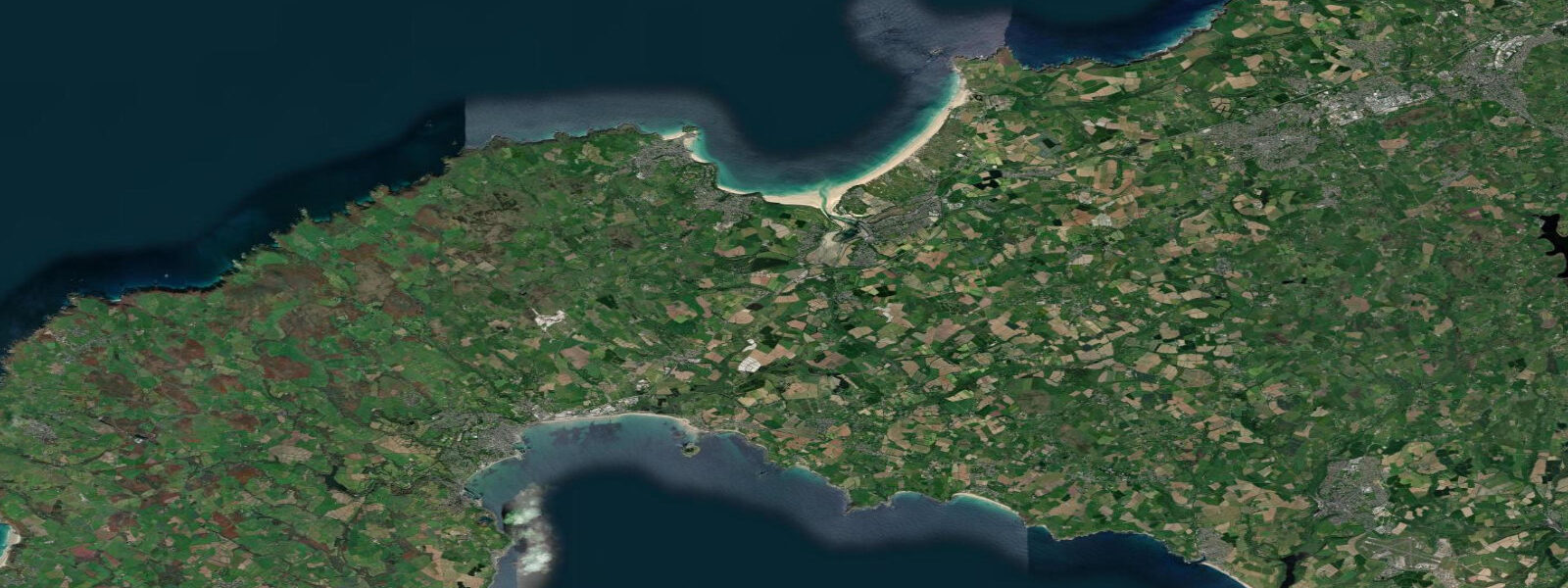
St Ives sits on the north Cornish coast at the western end of St Ives Bay, with the working harbour and the long sand of Porthmeor on the open Atlantic side and the curve of Carbis Bay sweeping east toward Hayle Towans and the Hayle estuary mouth. 5 on neaps. The pattern is two highs and two lows of comparable size each day, twelve and a half hours apart.
That swing transforms the day on every coast in Cornwall, and St Ives is no exception — the harbour at Smeaton's Pier dries out completely on spring lows, with the local fishing fleet sitting on the sand for hours, and the wide expanse of Porthminster and Porthmeor sands widens by tens of metres at the bottom of the cycle. The Hayle estuary across the bay drains almost completely on each ebb to a thin channel and refills over a four-hour flood, and the inner saltmarsh at Lelant becomes a network of tidal creeks rather than a single waterway. Surfers reading Porthmeor for the lowest tides of the month find the bottom contour reshaped from a peaky beach break to a longer left-handed wall.
The Tate St Ives sits directly behind Porthmeor and the gallery's view changes through every tide. Lowest spring lows around new and full moons open the rocky shore at the Island and the cliff base east of the harbour for tidepooling — the granite intertidal at the western tip of Cornwall is among the best in southern England. UK Hydrographic Office Admiralty TotalTide is the authoritative British tide product; Open-Meteo Marine drives the gridded predictions on this page.
Tide questions about St Ives, Cornwall
Quick answers to the most common questions about tide times, range, and water access at St Ives, Cornwall.
When is the next high tide at St Ives?
The hero block shows the next high tide at St Ives in local UK time (GMT in winter, BST in summer). The 7-day table covers all the highs and lows. High water at St Ives is close to in-phase with Newquay further down the north coast and arrives about an hour ahead of the Bristol Channel ports further east.
What's the typical tide range at St Ives?
Mean range is about 4.5 metres, climbing past 6.5 metres on the largest spring tides and dropping near 2.5 metres on neaps. The pattern is cleanly semidiurnal — two highs and two lows of comparable size each day, twelve and a half hours apart, the standard north Cornish signal. The Hayle estuary across the bay drains almost completely on each ebb.
Where do these tide predictions come from?
Open-Meteo Marine, a gridded global ocean model. Useful for daily planning around St Ives Bay, the Hayle estuary, and the open Atlantic coast. For authoritative British tide data, the UK Hydrographic Office's Admiralty TotalTide product is the navigation-grade reference, and the National Tide and Sea Level Facility operates the gauge network.
Where are the best tidepool walks at St Ives?
The rocky shore around the Island (the headland north-west of the harbour) and the cliff base east of the harbour both open up reliably on the lowest tides of the month, around new and full moons when the predicted low drops below 0.5 metres above chart datum. The granite intertidal at the western tip of Cornwall is among the best in southern England — go an hour either side of the lowest predicted low and stay above the rising flood.
Is this safe to use for navigation?
No. For piloting in or out of St Ives Harbour, transiting the Hayle bar, or working the open Atlantic coast use UKHO Admiralty charts and TotalTide predictions, the local harbour-master's guidance, and the Falmouth Coastguard's notices to mariners. The Hayle bar in particular is a working hazard at low water and in onshore swell.
8-day tide table — St Ives, Cornwall
Heights relative to MSL. Predictions: Open-Meteo Marine (MeteoFrance SMOC, 0.08° grid) — heights relative to MSL (not chart datum / LAT). Model-derived.
| Day | Type | Time | Height |
|---|---|---|---|
| Sun 26 Jul | Low | 01:00 | 0.3m / 1.1ft |
| High | 03:01 | 1.1m / 3.7ft | |
| Low | 09:25 | -1.7m / -5.6ft | |
| High | 15:24 | 1.3m / 4.4ft | |
| Low | 22:02 | -2.0m / -6.5ft | |
| Mon 27 Jul | High | 03:55 | 1.2m / 4.1ft |
| Low | 10:18 | -2.0m / -6.5ft | |
| High | 16:15 | 1.6m / 5.3ft | |
| Low | 22:46 | -2.2m / -7.4ft | |
| Tue 28 Jul | High | 04:38 | 1.5m / 5.1ft |
| Low | 10:59 | -2.3m / -7.5ft | |
| High | 16:57 | 1.9m / 6.2ft | |
| Low | 23:24 | -2.4m / -8.0ft | |
| Wed 29 Jul | High | 05:15 | 1.8m / 6.0ft |
| Low | 11:36 | -2.5m / -8.3ft | |
| High | 17:33 | 2.1m / 6.9ft | |
| Low | 23:59 | -2.7m / -8.9ft | |
| Thu 30 Jul | High | 05:51 | 1.9m / 6.3ft |
| Low | 12:08 | -2.8m / -9.2ft | |
| High | 18:08 | 2.3m / 7.5ft | |
| Fri 31 Jul | Low | 00:32 | -2.9m / -9.5ft |
| High | 06:25 | 2.0m / 6.7ft | |
| Low | 12:42 | -2.9m / -9.7ft | |
| High | 18:41 | 2.3m / 7.7ft | |
| Sat 01 Aug | Low | 01:04 | -3.1m / -10.1ft |
| High | 06:59 | 2.1m / 6.8ft | |
| Low | 13:14 | -3.0m / -9.9ft | |
| High | 19:14 | 2.4m / 7.9ft | |
| Sun 02 Aug | Low | 00:00 | -2.2m / -7.2ft |