Neiafu, Vava'u, Tonga tide times
Neiafu, Vava'u, Tonga tide forecast — heights relative to MSL.
Tide chart for Neiafu, Vava'u, Tonga
24-hour cosine-interpolated curve around the present moment. Heights relative to MSL. Predictions: Predictions: Open-Meteo Marine (MeteoFrance SMOC, 0.08° grid).
Sun, moon and conditions on Mon 06 Jul
Snapshot at build time — refreshes daily. Sea state from Open-Meteo Marine.
Highs and lows next 7 days
Every predicted high and low for the next week, with the daily tidal coefficient (0–120; higher = bigger swing, > 95 means stronger currents).
Other spots nearby
The three closest curated TideTurtle locations to Neiafu, Vava'u, Tonga, measured by great-circle distance.
Today's solunar windows
Solunar tradition: major periods are the ≈3h windows around moon transit and opposition; minor are ≈2h around moonrise and moonset. Pair with the local tide stage and wind for the best read.
Cycle dates near Neiafu, Vava'u, Tonga
Next spring tide on Fri 10 Jul (range 1.0m). Last neap on Sat 04 Jul.
Spring tides cluster around new and full moons (biggest swings). Neap tides land on quarter moons (smallest swings). See the spring tide and neap tide glossary entries for the why.
About tides at Neiafu, Vava'u, Tonga
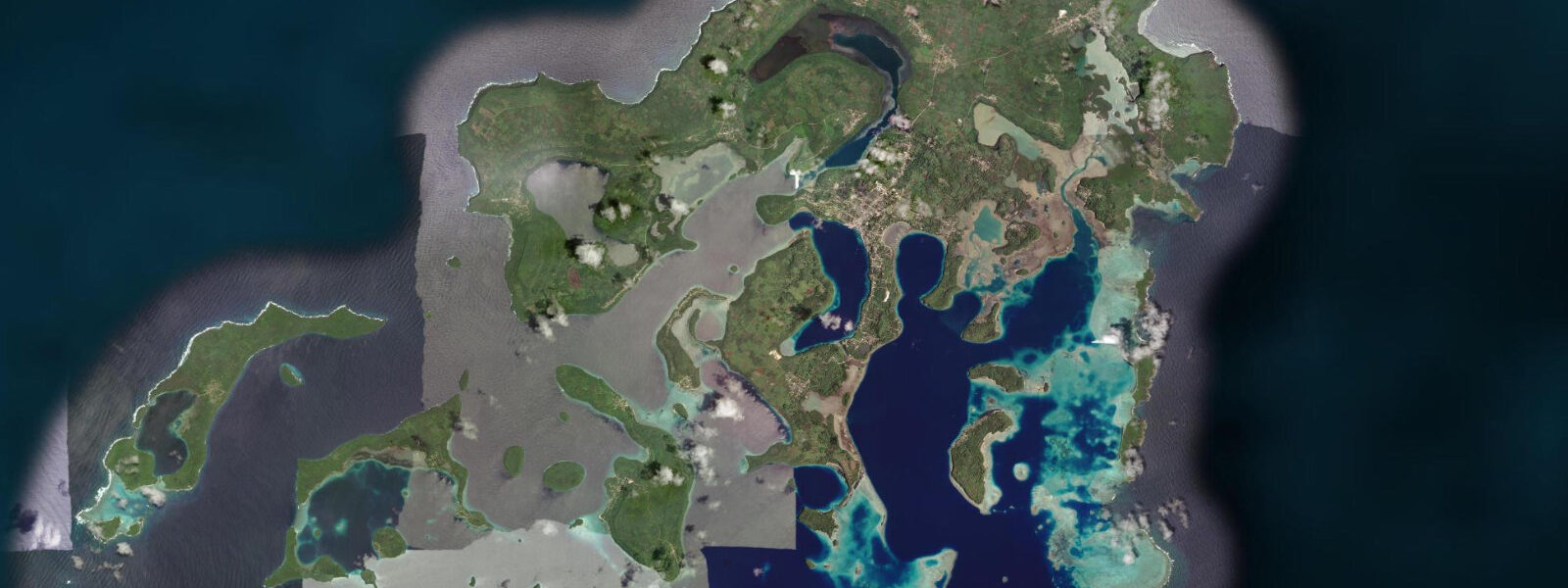
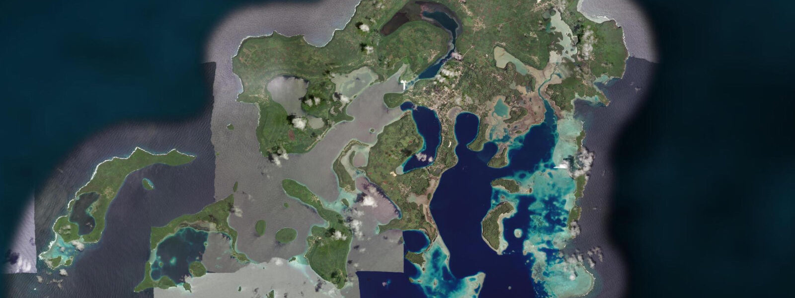
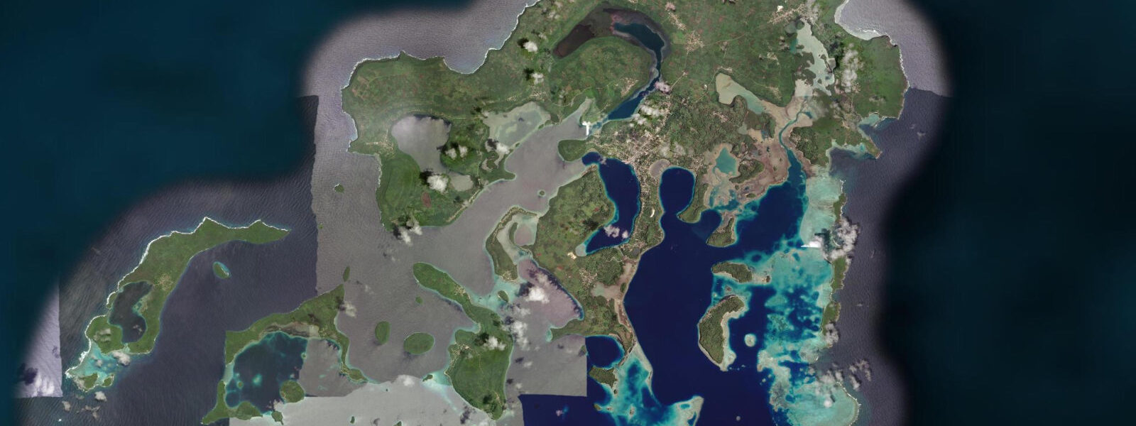
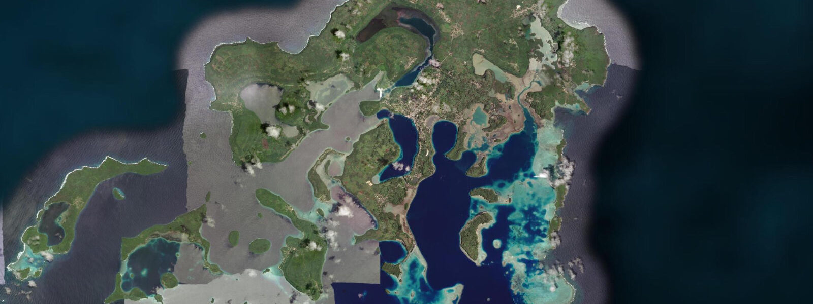
A short guide to the coastline at Neiafu, Vava'u, Tonga — geography, sea state, and what the tide is actually doing under your feet.
Neiafu is the main town of the Vava'u island group and the hub for one of the most concentrated marine tourism economies in the Pacific. The town sits on a peninsula above Port of Refuge — a drowned valley system producing a deepwater harbour enclosed by 40-plus islands, passages, and anchorages that can accommodate 50 yachts without any sense of crowding. The harbour and the island network around it make Vava'u the most celebrated cruising destination in the South Pacific for yachts on Pacific crossing voyages.
July through October is the operating season, and the reason is humpback whales. Southern Ocean humpbacks migrate annually from Antarctic feeding grounds to the warm, sheltered Vava'u waters to calve and nurse their young. Tonga is one of very few countries that permits regulated swim-with-whale encounters under controlled conditions: licensed operators hold permits that limit the number of simultaneous swimmers per whale encounter, mandate respectful approach distances, and prohibit pursuit or separation of mothers from calves. The Vava'u waters, with their sheltered island geometry keeping the whales calm and accessible in relatively shallow bays, are consistently rated the best swim-with-whale destination on Earth. Cow-calf pairs in the shallow protected bays of the southern group islands are the defining encounter — the calf's curiosity often driving the approach. Male singers produce their haunting low-frequency calls from the deeper passages; hydrophones dropped from the boats pick up the music while the dive crew enters elsewhere.
Outside the July–October window the charter sailing fleet scales back significantly, but the island group remains an active cruising destination year-round. Swallows Cave on Kapa Island — 15 minutes by speedboat from Neiafu — is accessible by kayak at water level on calm days: a low arch opening from a narrow sea entrance into a vaulted cavern with blue-green illuminated water and swallows nesting in the ceiling crevices. The island sea-kayaking network runs through 40-plus islands; multi-day routes with overnight stays in villages are available through local operators, with the kayak route following the sheltered inter-island passages where tidal current is the planning variable.
The Pacific mixed semidiurnal tidal regime here produces a spring range of 1.0 to 1.5 m. The inter-island passages run 0.5 to 1.0 knots on spring tides — important for sea kayakers planning overnight crossings, and for whale-watch boat positioning in the strong current zones of the eastern passage where the whales shelter from ocean swell. Anglers working the deep-water edge of the outer reef at the Vava'u group's eastern face catch wahoo, mahi-mahi, and yellowfin tuna on the tide turns; the ledge where the reef drops to deep water is the productive boundary. Predictions on this page come from Open-Meteo Marine (gridded model, ±45 min / ±0.2–0.3 m). The Vava'u sailing charter fleet — primarily based at the Port of Refuge anchorage in front of Neiafu — runs bare-boat and crewed charter itineraries through the 40-plus island network from July through November. The fleet peaks in September and October; most boats are booked by October by late December of the previous year for the whale-watch season. Early booking is essential for a bare-boat charter during the July–October peak. The Vava'u Group is a cruising yacht destination that fills each year with the passage fleet arriving from New Zealand in May and June. The anchorages in the group — Port Maurelle, Kapa Island, Swallows Cave, Mariner's Cave — are reef-sheltered and mostly deep enough to be tide-neutral for anchored vessels. However, tidal current in the main Neiafu channel affects dinghy travel between the town and the outer anchorages; outboard dinghy operators allow for current in their timing. Whale watching (humpback whales, July through October) is conducted in the ocean passages to the north and south of the group; current in these passages strengthens on the ebb and whales frequently surface in the current lines, a behaviour well-known to local operators. Fishing from the outer reef edges works best on the late flood when current concentrates baitfish at the reef tips. Sea kayaking tours through the inner lagoon use tidal current to assist crossings between islands; the typical morning tour runs with the flood, returns on the ebb.
Tide questions about Neiafu, Vava'u, Tonga
Quick answers to the most common questions about tide times, range, and water access at Neiafu, Vava'u, Tonga.
When is the next high tide at Neiafu?
The hero block shows the next predicted high at Neiafu in Tonga Standard Time (TOT, UTC+13). Pacific mixed semidiurnal, spring range 1.0 to 1.5 m. The inter-island passages in the Vava'u group run 0.5 to 1.0 knots at springs — relevant for sea kayakers timing crossings and for whale-watch operators positioning boats. The 7-day table covers all tidal extremes. Predictions from Open-Meteo Marine (gridded model, ±45 min / ±0.2–0.3 m). The inter-island passage current of 0.5 to 1.0 knots at springs is particularly relevant for sea kayakers crossing between the outer islands; time crossings to use the flood current in the direction of travel.
What is the tidal range at Neiafu, Vava'u?
Spring range runs 1.0 to 1.5 m; neap range about 0.5 to 0.7 m. The drowned valley geometry of Port of Refuge produces a gentle current at the harbour entrance — relevant for yachts manoeuvring in tight quarters. The inter-island channel currents of 0.5 to 1.0 knots at springs are the more operationally significant tidal effect for small boats and sea kayakers. Port of Refuge's drowned-valley geometry means the harbour itself is largely current-free; the passages outside the main harbour entrance are where tidal current is significant.
Where do these predictions come from?
Open-Meteo Marine, a free gridded global ocean model, accuracy ±45 min / ±0.2–0.3 m. Tonga Meteorological Service publishes tidal data; the reference station for Vava'u is Neiafu. The small timing offset between Nuku'alofa (Tongatapu) and Neiafu is accounted for in the Tonga Met tide tables. Tonga Meteorological Service publishes tidal data; the Neiafu reference station is in the Tonga tide tables. The timing is specific to Vava'u and does not require the same Nuku'alofa offset correction used for Tongatapu. Official tide tables for Tongan ports are produced by the Tonga Meteorological Service; the Neiafu port gauge provides the local harmonic reference.
When is the best time to see humpback whales at Vava'u?
The Vava'u humpback season runs July through October, peaking in August and September. Cow-calf pairs arrive from June; male singing behaviour and competitive heat run groups are more common from August through September. July and October are shoulder months with lower whale density but also lower visitor pressure. Day tours depart from Neiafu harbour; in peak season (August–September) booking 2 to 3 days in advance is recommended. Operators hold a permit for a limited number of simultaneous swimmers per encounter; follow the guide's instructions in the water without exception.
Is this safe to use for navigation?
No. TideTurtle is a planning tool. The Vava'u island passages, Port of Refuge entrance channel, and the outer Vava'u reef approaches require proper chart navigation. Use Tonga Hydrographic Office chart products for vessel operations. The island passage network has tidal current and reef hazards on the outer margins. Tonga Hydrographic Office chart products cover the Vava'u group; the island passage network has reef hazards and tidal current on the outer margins requiring chart navigation for vessel operations. For navigation in Vava'u waters, use official Tongan tide tables and chart products. The Vava'u Marine Park harbourmaster at Neiafu is the practical local contact for navigation questions.
7-day tide table — Neiafu, Vava'u, Tonga
Heights relative to MSL. Predictions: Open-Meteo Marine (MeteoFrance SMOC, 0.08° grid) — heights relative to MSL (not chart datum / LAT). Model-derived.
| Day | Type | Time | Height |
|---|---|---|---|
| Mon 06 Jul | Low | 04:10 | 0.4m |
| High | 10:16 | 1.0m | |
| Low | 16:37 | 0.3m | |
| High | 22:56 | 1.0m | |
| Tue 07 Jul | Low | 05:00 | 0.4m |
| High | 11:07 | 1.0m | |
| Low | 17:22 | 0.3m | |
| High | 23:43 | 1.0m | |
| Wed 08 Jul | Low | 05:52 | 0.4m |
| High | 12:00 | 1.0m | |
| Low | 18:06 | 0.3m | |
| Thu 09 Jul | High | 00:35 | 1.1m |
| Low | 06:48 | 0.3m | |
| High | 12:52 | 1.1m | |
| Low | 18:54 | 0.3m | |
| Fri 10 Jul | High | 01:13 | 1.2m |
| Low | 07:36 | 0.3m | |
| High | 13:42 | 1.1m | |
| Low | 19:46 | 0.3m | |
| Sat 11 Jul | High | 02:08 | 1.2m |
| Low | 20:40 | 0.3m | |
| Sun 12 Jul | High | 03:00 | 1.2m |
| Low | 09:25 | 0.2m | |
| High | 12:00 | 0.5m |