Neiafu, Vava'u tide times
Neiafu, Vava'u tide forecast — heights relative to MSL.
Tide chart for Neiafu, Vava'u
24-hour cosine-interpolated curve around the present moment. Heights relative to MSL. Predictions: Predictions: Open-Meteo Marine (MeteoFrance SMOC, 0.08° grid).
Sun, moon and conditions on Mon 29 Jun
Snapshot at build time — refreshes daily. Sea state from Open-Meteo Marine.
Highs and lows next 7 days
Every predicted high and low for the next week, with the daily tidal coefficient (0–120; higher = bigger swing, > 95 means stronger currents).
Other spots nearby
The three closest curated TideTurtle locations to Neiafu, Vava'u, measured by great-circle distance.
Today's solunar windows
Solunar tradition: major periods are the ≈3h windows around moon transit and opposition; minor are ≈2h around moonrise and moonset. Pair with the local tide stage and wind for the best read.
Cycle dates near Neiafu, Vava'u
Last spring tide on Sat 27 Jun (range 0.8m). Next neap on Sun 28 Jun.
Spring tides cluster around new and full moons (biggest swings). Neap tides land on quarter moons (smallest swings). See the spring tide and neap tide glossary entries for the why.
About tides at Neiafu, Vava'u
A short guide to the coastline at Neiafu, Vava'u — geography, sea state, and what the tide is actually doing under your feet.
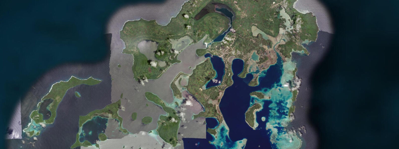
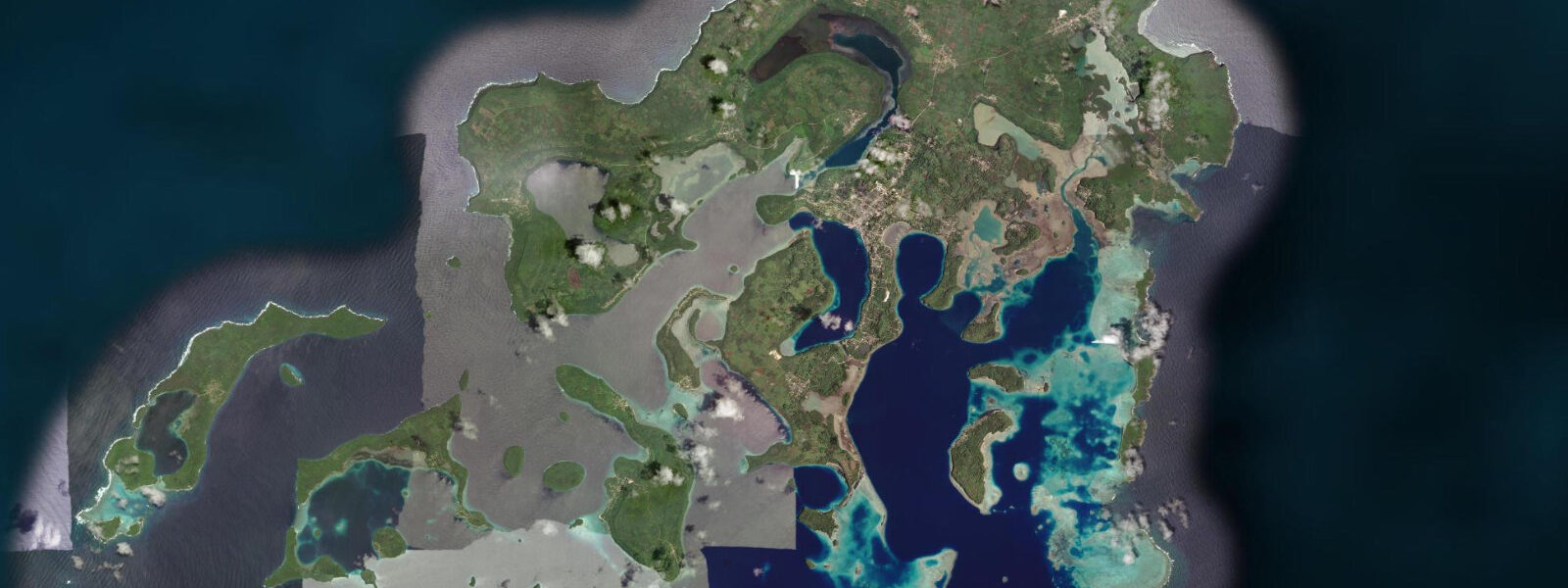
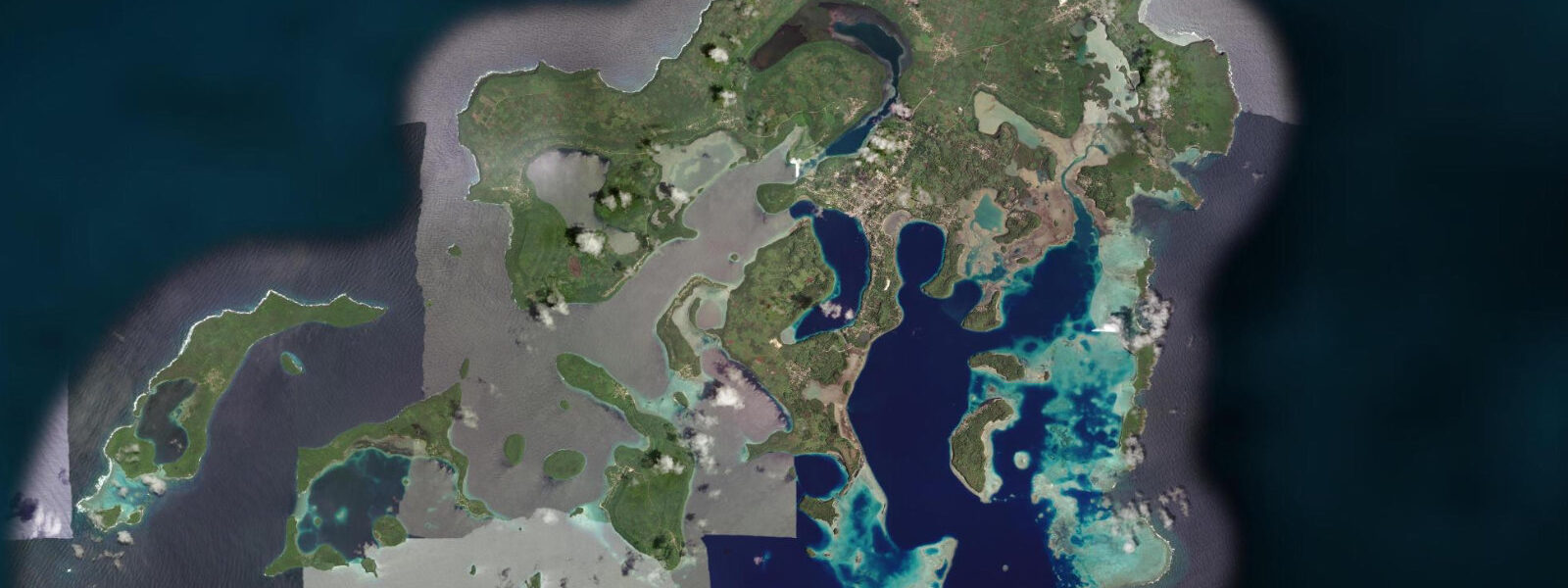
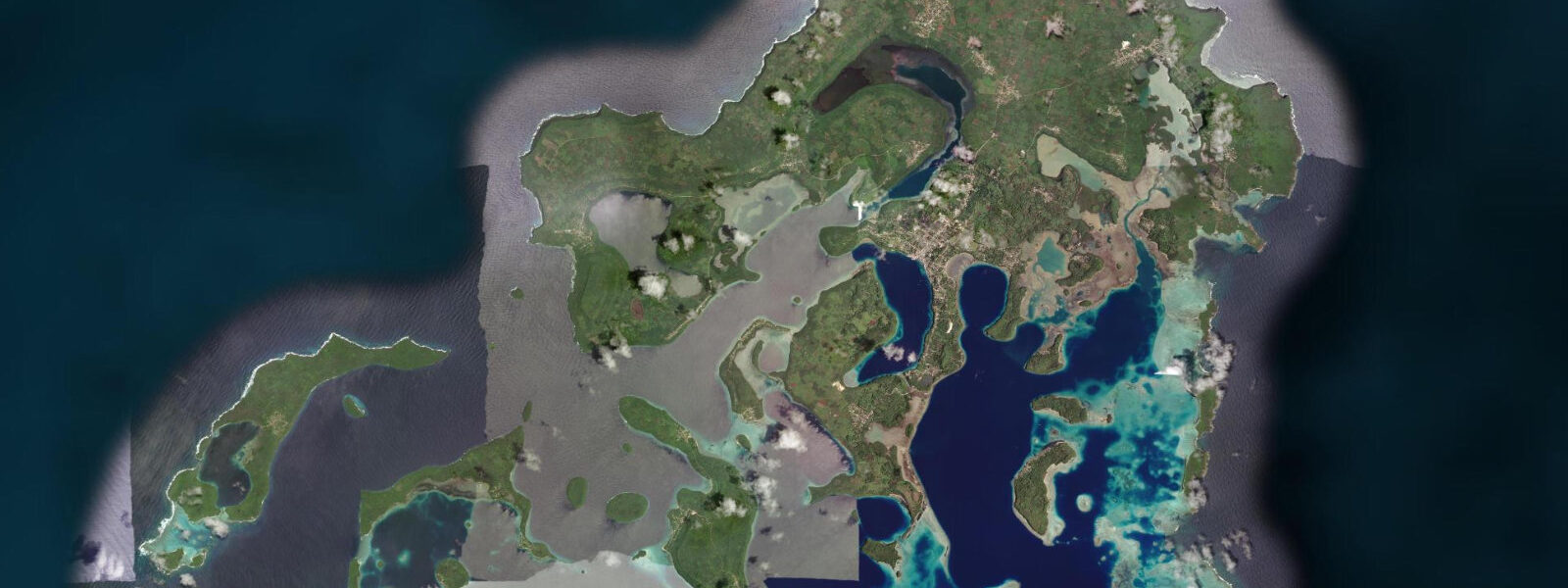
Neiafu is the main town of the Vava'u island group, 250 km north of Tongatapu, and it sits above one of the Pacific's most spectacular cruising harbours. The Port of Refuge — a drowned volcanic system enclosed by a maze of limestone islands — provides 40 km of navigable, fully sheltered water accessible through a single main pass. The inner harbour is deep enough for ocean-going sailing yachts; the outer anchorages in the island passages can carry 20–30 boats on a busy season weekend. The town looks down from a ridge 30 m above the waterfront, with the main market, the Tonga Communications office, and the waterfront bars visible from any boat in the inner harbour.
The tidal regime at Neiafu is mixed semidiurnal, broadly consistent with Tongatapu but slightly modified by the enclosed harbour geometry. Spring range in the Port of Refuge runs 1.2–1.4 m above Chart Datum — the enclosure damps it marginally compared to the open coast. Neap range 0.4–0.6 m. The mixed character remains: the two daily highs differ by 0.3–0.5 m on spring tides, which matters for the shallowest reef passages between the outer islands where draft clearance is calculated to 0.2 m precision by local skippers.
July through October is humpback whale season in Vava'u. Southern Ocean humpbacks migrate north to Tonga's warm water to calve, nurse, and mate; Vava'u is considered one of the premier locations globally for permitted in-water encounters with humpback whales. Whale watching boats depart from Neiafu's main wharf daily during the season. The whales use the deep-water channels between the limestone islands — passages where tidal current runs at 0.8–1.5 knots on spring tides — as movement corridors. Operators working these channels plan their routes partly around tidal current to minimise engine running alongside animals.
For kayakers, Vava'u's island maze is exceptional flat-water touring terrain. The 40 km of enclosed water contains dozens of limestone islands, sea caves accessible from water level, and pristine beaches on uninhabited islets. The tidal current in the main inner harbour channels runs at 0.5–1.0 knots on spring tides — noticeable but manageable for competent kayakers over short passages. The sea caves in the outer islands — particularly Mariner's Cave, a submerged entrance accessible only by diving through a tidal tube — require precise timing: the entrance is accessible when the tidal range produces at least 0.3 m of rise and fall to breathe the air pocket at the cave ceiling.
Anglers in Vava'u target mahi-mahi, yellowfin tuna, wahoo, and marlin in the open ocean outside the main pass. The pass itself — the Pulepulekai entrance on the southwest — runs at 2.5–3.5 knots on spring ebb, creating a current rip where surface current meets the more sluggish outer water. Trolling across this rip on the ebb is one of the most reliable wahoo setups in the group. Inside the harbour, the deeper channels between islands hold large grouper and snapper on the bottom; jig vertically on the ebb at the channel edges for the best results.
Photographers come to Vava'u for two subjects: whales and limestone scenery. Whale encounters at dawn — before wind and boat traffic build — are the prime photographic window. Low-angle morning light into the passage between the limestone cliffs creates the compressed perspective that makes the islands look more dramatic than they are from overhead. The Port of Refuge anchorage at sunrise, with masts rising above flat water and the town ridge in the background, is the classic shot. Low spring water exposes the waterline bands of white limestone and dark coral growth on the island bases — this textural contrast is best photographed from water level in a kayak.
All tide predictions for Neiafu, Vava'u come from the Open-Meteo Marine gridded model. Timing accuracy is ±45 minutes; height accuracy is ±0.3 m above Chart Datum.
Tide questions about Neiafu, Vava'u
Quick answers to the most common questions about tide times, range, and water access at Neiafu, Vava'u.
Does the tidal state affect humpback whale watching in Vava'u?
Whale sightings are not tidal-dependent — humpbacks are present throughout the day regardless of tide. However, the tidal current in the deep passages between the limestone islands influences how operators position boats. Spring tides run 0.8–1.5 knots through the main channels; experienced operators use the current to drift quietly alongside animals rather than idling engines. Encounters early in the morning on calm days produce the best photographic light and the least boat traffic. The season runs July through October; October arrivals find fewer whales but calmer trade-wind conditions and better underwater visibility.
What is Mariner's Cave and when is the tidal window to enter it?
Mariner's Cave is a sea cave in the outer Vava'u islands with a submerged entrance — accessed by diving beneath the limestone cliff face and surfacing inside an air pocket. The entrance depth is approximately 3–4 m below the surface at mean sea level. The cave is most safely accessible when tidal range is 0.6 m or greater, which generates enough air-pressure change in the ceiling cavity to be noticeable without becoming dangerous. At spring tides above 1.2 m, the pressure differential on each passing wave produces a dramatic misting effect as the air compresses. Enter only with local knowledge of the passage and verify tidal state against the Open-Meteo prediction with its ±45 minute uncertainty factored in.
How does tidal current affect kayaking through the island passages?
The main inner harbour channels run 0.5–1.0 knots on spring tides — noticeable but not challenging for a competent sea kayaker over short passages. Plan multi-day tours to use the flood current for outbound legs in the morning and the ebb for return legs in the afternoon, roughly matching the trade-wind cycle. The outer islands beyond the Port of Refuge proper experience stronger tidal currents and more exposed swell — treat those as advanced sections requiring local knowledge. Open-Meteo Marine predictions carry ±45 minutes timing uncertainty; factor extra buffer into current-assisted passages.
What is the best fishing strategy at the main Pulepulekai pass?
The Pulepulekai entrance on the southwest runs at 2.5–3.5 knots on spring ebb, creating a current rip where the fast outflow meets the slower outer water. Troll across this rip perpendicular to the current flow on the spring ebb for wahoo — the rip line concentrates baitfish. Run lures at 7–8 knots and cover the rip in repeated passes. The flood current also fishes well for mahi-mahi on the surface — surface poppers and stickbaits cast up-current and retrieved across the rip provoke aggressive strikes. Inside the pass, jig vertically at the channel edges on the ebb for large grouper and snapper at 30–60 m depth.
When is the best time to photograph the Port of Refuge anchorage?
Sunrise is the prime window: flat water, mast reflections, and light entering the harbour from the northeast. Low spring water exposes the waterline limestone-and-coral banding on the island bases — the white limestone above and dark intertidal zone below — which reads well in early horizontal light. The combination of low spring water and sunrise occurs roughly four to six days per lunar cycle. Check TideTurtle for predicted low water between 05:30 and 07:00 local time. Afternoon light from 15:00–17:00 works the west-facing cliff faces and is better for kayak-level shots of the sea cave entrances.
6-day tide table — Neiafu, Vava'u
Heights relative to MSL. Predictions: Open-Meteo Marine (MeteoFrance SMOC, 0.08° grid) — heights relative to MSL (not chart datum / LAT). Model-derived.
| Day | Type | Time | Height |
|---|---|---|---|
| Mon 29 Jun | High | 05:22 | 1.1m |
| Low | 11:52 | 0.3m | |
| High | 17:56 | 0.9m | |
| Low | 23:47 | 0.4m | |
| Tue 30 Jun | High | 06:00 | 1.1m |
| Wed 01 Jul | Low | 13:16 | 0.3m |
| High | 19:22 | 1.0m | |
| Thu 02 Jul | Low | 01:15 | 0.4m |
| High | 07:23 | 1.1m | |
| Low | 14:00 | 0.3m | |
| High | 20:03 | 0.9m | |
| Fri 03 Jul | Low | 01:55 | 0.4m |
| High | 08:07 | 1.1m | |
| Low | 14:42 | 0.3m | |
| High | 20:45 | 1.0m | |
| Sat 04 Jul | Low | 02:38 | 0.4m |
| High | 08:50 | 1.1m | |
| Low | 15:18 | 0.3m |