Chole Bay tide times
Chole Bay tide forecast — heights relative to MSL.
Today's tide times for Chole Bay
Tide times at Chole Bay on Saturday, 4 July 2026: first low tide at 03:00am, first high tide at 06:08am, second low tide at 12:04pm, second high tide at 06:16pm. Sunrise 06:34am, sunset 06:15pm.
Tide chart for Chole Bay
24-hour cosine-interpolated curve around the present moment. Heights relative to MSL. Predictions: Predictions: Open-Meteo Marine (MeteoFrance SMOC, 0.08° grid).
Sun, moon and conditions on Sat 04 Jul
Snapshot at build time — refreshes daily. Sea state from Open-Meteo Marine.
Highs and lows next 7 days
Every predicted high and low for the next week, with the daily tidal coefficient (0–120; higher = bigger swing, > 95 means stronger currents).
Other spots nearby
The three closest curated TideTurtle locations to Chole Bay, measured by great-circle distance.
Today's solunar windows
Solunar tradition: major periods are the ≈3h windows around moon transit and opposition; minor are ≈2h around moonrise and moonset. Pair with the local tide stage and wind for the best read.
Cycle dates near Chole Bay
Last spring tide on Sat 04 Jul (range 2.7m). Next neap on Fri 10 Jul.
Spring tides cluster around new and full moons (biggest swings). Neap tides land on quarter moons (smallest swings). See the spring tide and neap tide glossary entries for the why.
About tides at Chole Bay
A short guide to the coastline at Chole Bay — geography, sea state, and what the tide is actually doing under your feet.
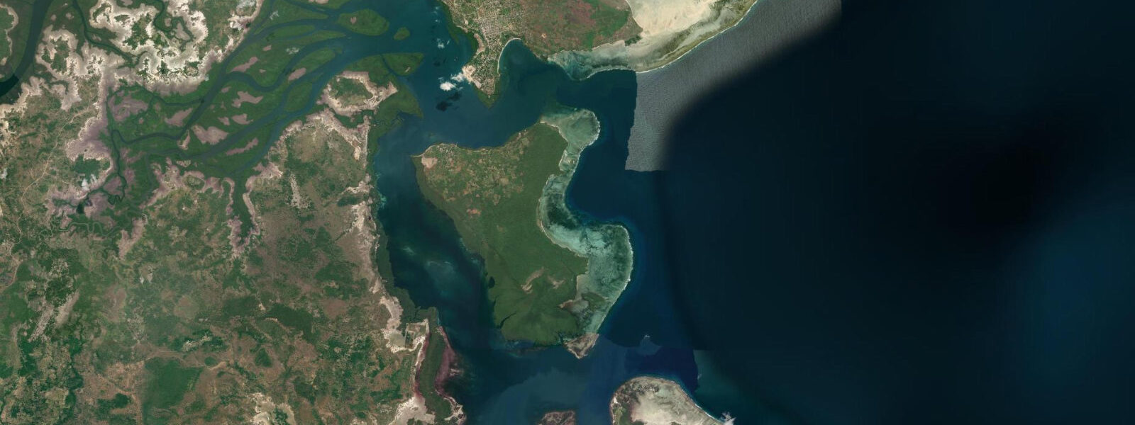
Chole Bay is the main anchorage of Mafia Island Marine Park, a sheltered body of water between Mafia Island to the west and the smaller islands of Chole, Juani, and Jibondo to the east. The bay is protected from the open Indian Ocean swell by its island geography, which makes it the operational hub of the marine park — dive boats, fishing dhows, cargo vessels, and kayaks all share the same water. The tidal channel between Mafia and Chole Island runs 1 to 2 knots at spring tides, which is noticeable in a kayak or canoe but manageable if the direction is factored into route planning.
5 metres, consistent with the wider Mafia Island system. The most immediately visible effect of this range is on the bay's southern fringe, where mangrove and mudflat transition sharply between high and low water states. At high water the mangrove appears to stand in open water; at low water a wide belt of root system and dark mud is exposed, grazed by red-billed oxpeckers in the morning and by herons from mid-morning onwards.
The 19th-century Arab ruins on Chole Island — referred to collectively as Chole Mjini — are one of the more unusual coastal heritage sites in the western Indian Ocean. The ruins are extensive: coral-rag walls of former merchants' houses, warehouses, and a small citadel, now colonised by old baobab trees that have pushed through the masonry. The site is accessible at any state of tide — the island is reached by a 10-minute boat crossing from Utende on Mafia, and there is no tidal restriction on landing.
A small community-run canopy lodge operates within the ruins. Traditional dhow building is practised at the fishing cooperative on Jibondo Island, the southernmost of the Chole Bay island group. Jibondo has a strong fishing tradition; its fishermen operate ngalawa outriggers and larger motorised dhows through the bay channels and into offshore waters.
The cooperative continues to build traditional wooden dhows using adze and hand tools, and the process is visible to visitors who arrive during construction periods. There is no formal tour infrastructure — this is working boat construction, not a demonstration. Birdwatching in Chole Bay is productive in the mangrove fringe: mangrove kingfisher is resident, African fish eagle is frequently visible over the open water, and the mudflat at low tide draws waders (common sandpiper, whimbrel, greenshank) in the northern winter months.
The open bay also hosts Roseate tern over the water in the northeast monsoon season. For kayakers, the bay is navigable at any tide, but the current in the main channel between Mafia and Chole islands should be planned for rather than ignored. A circuit around Chole Island by kayak works best starting on the flood tide, crossing the channel with the current, circumnavigating the island, and returning across the channel as the flood slackens near high water.
The circuit is around 12 kilometres and takes 3 to 4 hours at a relaxed pace. Snorkelling directly within Chole Bay is possible but the sedimentation from tidal channels reduces visibility compared to the outer reef sites — visibility is typically 3 to 8 metres inside the bay versus 15 to 25 metres on the outer wall. The bay's seagrass beds are worth a shallow inspection for turtle, ray, and seagrass fauna even at low visibility.
Predictions on this page come from Open-Meteo Marine, a gridded global ocean model. 3 metres on height — model-derived, not from a local gauge. The national authorities are the Tanzania Meteorological Authority (TMA) and Tanzania Ports Authority; the Zanzibar gauge provides the nearest long-term tidal reference.
Tide questions about Chole Bay
Quick answers to the most common questions about tide times, range, and water access at Chole Bay.
What tidal current runs through Chole Bay?
The channel between Mafia Island and Chole Island runs at 1 to 2 knots on spring tides — most noticeable in the narrower sections north and south of the channel. On neap tides the current is noticeably weaker. For kayakers or canoe users, timing a crossing around slack water (roughly 45 minutes either side of high or low water) avoids being pushed off course. For motorised boats the current is manageable but visible in the wash — local boatmen factor it in automatically. The current direction reverses with the tide; on the flood it runs northward through the channel, on the ebb southward.
Can I visit the Chole Island ruins on a day trip from Mafia?
Yes. The crossing from Utende (the main accommodation cluster on Mafia) to Chole Island takes about 10 minutes by local boat and can be made at any state of tide. The ruins of Chole Mjini are on the island itself and are accessible on foot without restriction. Most dive and snorkel operators at Utende can arrange a combined morning dive followed by a visit to Chole in the afternoon. Staying at the canopy lodge within the ruins is also possible if booked in advance, which gives full access to the site in the quieter early morning and evening.
Where is traditional dhow building practised in Chole Bay?
The fishing community on Jibondo Island, at the southern end of the Chole Bay island group, continues to build traditional wooden dhows using hand tools. The construction process is not a demonstration for visitors — it is the community's working boat industry — but visitors who arrive during active construction can observe the process from a respectful distance. There is no scheduled access or entry fee. A local boatman from Utende or Kilindoni can take you to Jibondo; the crossing is about 20 to 30 minutes from Utende.
Is snorkelling inside Chole Bay worth doing?
Chole Bay's seagrass beds and shallow reef patches are worth a look, but do not expect the visibility you get on the outer reef wall. Inside the bay, tidal sediment from the channels typically limits visibility to 3 to 8 metres. The seagrass beds can hold green turtles, reef rays, and a good range of small reef fish. Snorkelling around the Chole Island mangrove fringe at high tide is a different and rewarding experience — enclosed, tidal, and rich in small life — but it is not the open-water reef snorkel the outer sites provide. For clear water coral reef, plan a trip to the outer reef.
What birds can I see in Chole Bay?
Mangrove kingfisher is resident along the mangrove fringe of the bay, most visible in the early morning. African fish eagle is regularly seen perched in tall trees above the bay or flying low over the water. At low water, the exposed mudflat on the southern margin of the bay draws waders in northern winter: common sandpiper, greenshank, and whimbrel are the most frequent. Roseate tern and lesser crested tern are seen over open water in the northeast monsoon season. Pied kingfisher hunts over the channel edges at all tide states.
8-day tide table — Chole Bay
Heights relative to MSL. Predictions: Open-Meteo Marine (MeteoFrance SMOC, 0.08° grid) — heights relative to MSL (not chart datum / LAT). Model-derived.
| Day | Type | Time | Height |
|---|---|---|---|
| Sat 04 Jul | Low | 03:00 | 0.2m |
| High | 06:08 | 1.5m | |
| Low | 12:04 | -0.8m | |
| High | 18:16 | 1.8m | |
| Sun 05 Jul | Low | 00:35 | -0.9m |
| High | 06:44 | 1.5m | |
| Low | 12:42 | -0.7m | |
| High | 18:53 | 1.6m | |
| Mon 06 Jul | Low | 01:10 | -0.8m |
| High | 07:23 | 1.5m | |
| Low | 13:25 | -0.6m | |
| High | 19:32 | 1.5m | |
| Tue 07 Jul | Low | 01:50 | -0.7m |
| High | 08:08 | 1.4m | |
| Low | 14:17 | -0.5m | |
| High | 20:19 | 1.2m | |
| Wed 08 Jul | Low | 02:35 | -0.6m |
| High | 09:03 | 1.4m | |
| Low | 15:21 | -0.4m | |
| High | 21:20 | 1.1m | |
| Thu 09 Jul | Low | 03:33 | -0.5m |
| High | 10:11 | 1.4m | |
| Low | 16:41 | -0.3m | |
| High | 22:40 | 0.9m | |
| Fri 10 Jul | Low | 04:43 | -0.4m |
| Sat 11 Jul | High | 00:11 | 0.9m |