Mirissa, Sri Lanka tide times
Mirissa, Sri Lanka tide forecast — heights relative to MSL.
Today's tide times for Mirissa, Sri Lanka
Tide times at Mirissa, Sri Lanka on Friday, 19 June 2026: first high tide at 05:30am, first low tide at 10:30am, second high tide at 04:30pm. Sunrise 05:55am, sunset 06:23pm.
Tide chart for Mirissa, Sri Lanka
24-hour cosine-interpolated curve around the present moment. Heights relative to MSL. Predictions: Predictions: Open-Meteo Marine (MeteoFrance SMOC, 0.08° grid).
Sun, moon and conditions on Fri 19 Jun
Snapshot at build time — refreshes daily. Sea state from Open-Meteo Marine.
Highs and lows next 7 days
Every predicted high and low for the next week, with the daily tidal coefficient (0–120; higher = bigger swing, > 95 means stronger currents).
Other spots nearby
The three closest curated TideTurtle locations to Mirissa, Sri Lanka, measured by great-circle distance.
Today's solunar windows
Solunar tradition: major periods are the ≈3h windows around moon transit and opposition; minor are ≈2h around moonrise and moonset. Pair with the local tide stage and wind for the best read.
About tides at Mirissa, Sri Lanka
A short guide to the coastline at Mirissa, Sri Lanka — geography, sea state, and what the tide is actually doing under your feet.
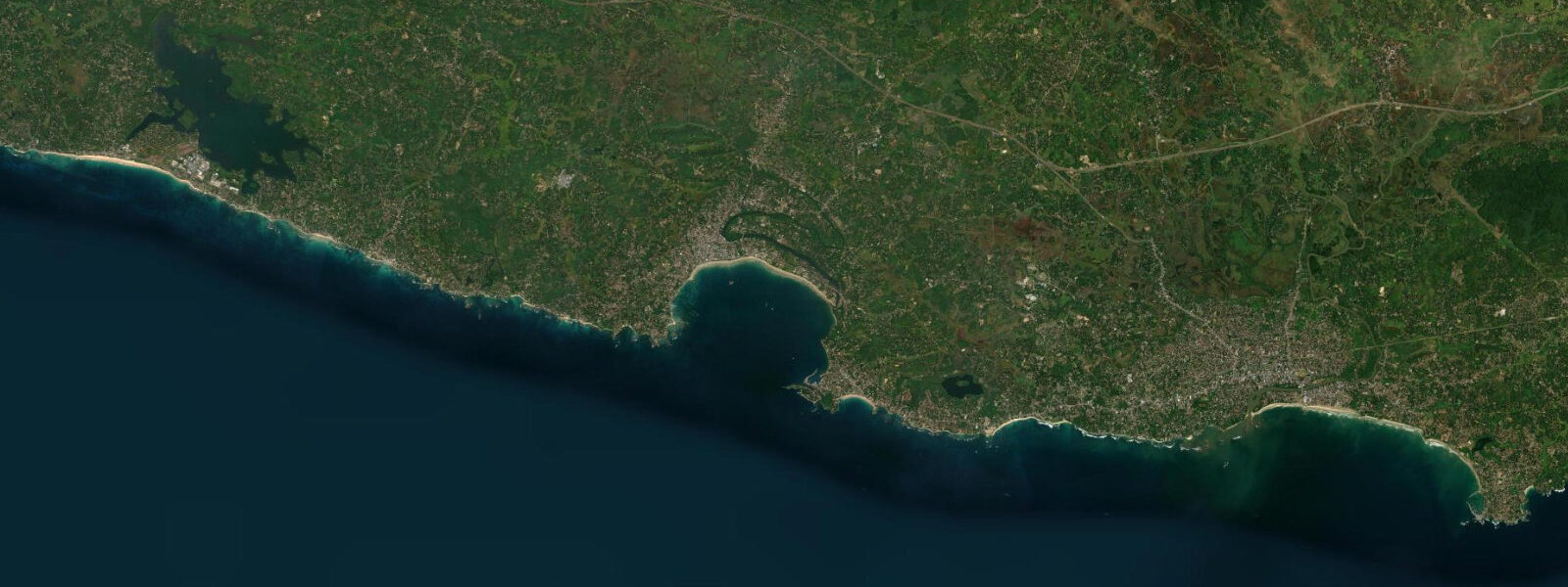
Mirissa is a 1.5 km beach bay in Matara District, 35 km east of Galle and 15 km west of Matara town on Sri Lanka's south coast. The beach curves southwest-to-northeast, backed by a coconut-palm ridge, with Parrot Rock — a small island 60 m offshore at the western end — breaking the line of the bay. To the east, the beach runs to a low headland where the bay meets the approach to Weligama. To the west, Mirissa Harbour occupies a sheltered cove behind the point, where the fishing fleet moors between trips.
The tidal regime on Sri Lanka's south coast is mixed semidiurnal with a mean spring range of 0.5–0.8 m. The vertical difference between high and low spring water at Mirissa is around 0.6 m — small by global standards, which means the beach width changes modestly across the tidal cycle (15–25 m between high and low spring) and the bay's usability is driven by swell, not tide. At low spring water the western end of Mirissa Beach extends further onto the sand and the rocky headland between the beach and Weligama Bay becomes partially accessible on foot — a 200 m walk on exposed reef and rock that is entirely submerged at high spring. At the Parrot Rock end, the channel between the island and the beach shallows to 0.8–1.0 m at low spring; experienced swimmers cross to the island at all tidal states, but the crossing is easier when water depth is 1.5–2.0 m on incoming tide rather than knee-deep over sharp coral.
Mirissa's defining characteristic is blue whale access. Balaenoptera musculus — the blue whale, the largest animal on Earth — feeds on the shallow shelf south of Sri Lanka from November through April. The shelf here runs south from Dondra Head lighthouse (8 km east of Mirissa, Sri Lanka's southernmost point) at depths of 100–300 m, within practical day-trip range of Mirissa Harbour. The whale watching fleet departs the harbour between 06:00 and 07:00 each morning during season — departure before 07:00 is important because the feeding zone 10–20 km offshore is reached before the afternoon southeast wind builds chop that makes whale watching difficult and uncomfortable. Return by 11:00 is standard. Blue whale encounters in Mirissa are surface-level: the whales surface to breathe every 10–15 minutes, roll their dorsal fin and flukes on deep dives, and occasionally breach. The 2–3 minute breathing cycle gives enough time to position a boat 200 m ahead of the whale's track. November through January produces the highest encounter frequency; February through April still yields encounters as the whales feed before their northward migration.
Sperm whales (Physeter macrocephalus) are present year-round in the deep water south of the continental shelf break. Spinner dolphins are the most reliably seen species on any whale watching trip — they frequently bow-ride the whale watching boats on the outward journey and are visible even when whales are not encountered. Operators who claim 100% whale sighting guarantees should be treated with scepticism; a well-run boat trip in peak season has an 80–90% success rate on blue whale encounters.
Parrot Rock is a small volcanic islet at the western end of Mirissa Beach, rising 4–5 m above sea level. At high spring water it is surrounded by 2–3 m of water; at low spring, the base of the rock is accessible on foot across a tidal reef. Swimmers cross the 60 m channel from the beach to the rock at all states, with the mid-incoming-tide depth of 1.5–2.0 m giving the easiest swim over the coral. The top of the rock is flat enough to stand on and gives an unobstructed view of the bay from above, including the whale watching boat departures from the harbour.
Mirissa Harbour is a working fishing port. The longline fleet — medium-sized vessels, 12–18 m, targeting yellowfin tuna (Thunnus albacares) and swordfish (Xiphias gladius) — operates year-round, departing on multi-day trips. The harbour wall at low spring water exposes the stone slipway used to haul smaller vessels for maintenance. The fish market operates in the early morning when offshore boats return; the tuna and swordfish landed here supply Galle and Colombo wholesale markets. The activity on the harbour at 05:30 — boats fuelling, crews boarding, whale watching passengers gathering — is a specific window that closes by 07:30 when everyone has left.
Dondra Head lighthouse, 8 km east at Sri Lanka's southernmost point, is the geographic landmark that marks the transition from the island's south coast to the east coast. The lighthouse is 50 m tall, automated, and open to visitors by arrangement. From Dondra Head on a clear day, the horizon to the south is unobstructed open Indian Ocean — the next landfall due south is Antarctica.
Tide data for Mirissa, Sri Lanka comes from the Open-Meteo Marine API, a gridded model product. Timing accuracy is ±45 minutes, height accuracy ±0.3 m — usable for trip planning, not for navigation.
Tide questions about Mirissa, Sri Lanka
Quick answers to the most common questions about tide times, range, and water access at Mirissa, Sri Lanka.
When is blue whale season at Mirissa and what time do the boats depart?
Blue whales feed on the shelf south of Sri Lanka from November through April, with the highest encounter frequency in November through January. The whale watching fleet at Mirissa Harbour departs between 06:00 and 07:00 each morning to reach the feeding zone 10–20 km offshore before the afternoon southeast wind builds chop. Return is typically by 11:00. November through January sees the most consistent encounters; February through April remains productive as whales continue feeding before the northward migration. Sperm whales are present year-round in deeper water beyond the shelf break, and spinner dolphins are reliably seen on nearly every trip regardless of blue whale success. A well-run operator in peak season achieves 80–90% blue whale encounter rates — treat any 100% guarantee with scepticism.
How does the tide affect access to Parrot Rock?
Parrot Rock is a small island 60 m offshore at the western end of Mirissa Beach, rising 4–5 m above sea level. At high spring water it is surrounded by 2–3 m of water; at low spring, the tidal reef at its base becomes accessible on foot from the beach. Swimmers cross the 60 m channel at all tidal states. The easiest swim is at mid-incoming tide when the depth is 1.5–2.0 m over the coral — shallow enough to see the bottom clearly, deep enough to swim without contact. At low spring the crossing shallows to 0.8–1.0 m over sharp reef — manageable but requires care underfoot. The top of the rock has a standing-room flat area with a full view of the bay and the whale watching boat departures from Mirissa Harbour below.
What tidal conditions expose the headland walk toward Weligama Bay?
At low spring water, the rocky headland at the eastern end of Mirissa Beach — where the bay meets the approach to Weligama — becomes partially accessible on foot. Approximately 200 m of reef and rock that is fully submerged at high spring water is exposed 30–60 minutes either side of low spring. The walk requires reef shoes; the surface is uneven and sharp coral is exposed. The timing window is narrow: the mean spring tidal range is only 0.5–0.8 m and the tide turns quickly on this coast. Check tide times and allow no more than 30 minutes on the exposed headland before returning. The view from the headland point at low water looks back across Mirissa Beach and west toward Weligama Bay.
Is the Mirissa fishing harbour worth visiting and when is the activity?
Mirissa Harbour is a working longline fishing port targeting yellowfin tuna and swordfish on multi-day trips. The peak activity window is 05:30–07:30 — offshore boats returning with catch overlap with the whale watching fleet fuelling and boarding passengers. The fish market is active as tuna and swordfish come off the boats. By 07:30 the whale watching fleet has departed and the harbour quiets. At low spring water the stone slipway on the harbour wall is exposed, where smaller vessels haul out for maintenance — a different and less-photographed side of the port. The harbour is 5 minutes walk from the main Mirissa Beach access point, accessible via the road around the western headland.
What is Dondra Head lighthouse and how does it relate to Mirissa?
Dondra Head lighthouse stands 8 km east of Mirissa at Sri Lanka's southernmost geographic point — latitude 5.92° N, where the south coast turns northeast toward the east coast. The lighthouse is 50 m tall, automated, and the most southerly structure on the island. From Dondra Head looking due south, the horizon is unobstructed open Indian Ocean with no landfall until Antarctica. The shelf edge that produces Mirissa's blue whale feeding zone runs south from this headland at 100–300 m depth. The lighthouse is accessible from the A2 coastal road and is open to visitors by prior arrangement with the Sri Lanka Ports Authority. It is a 20-minute tuk-tuk ride east from Mirissa along the coastal road through Matara district.
8-day tide table — Mirissa, Sri Lanka
Heights relative to MSL. Predictions: Open-Meteo Marine (MeteoFrance SMOC, 0.08° grid) — heights relative to MSL (not chart datum / LAT). Model-derived.
| Day | Type | Time | Height |
|---|---|---|---|
| Fri 19 Jun | High | 05:30 | 0.6m |
| Low | 10:30 | 0.3m | |
| High | 16:30 | 0.7m | |
| Sat 20 Jun | Low | 10:45 | 0.3m |
| High | 17:10 | 0.6m | |
| Low | 23:24 | 0.2m | |
| Sun 21 Jun | High | 17:20 | 0.6m |
| Mon 22 Jun | Low | 12:30 | 0.4m |
| Tue 23 Jun | — | ||
| Wed 24 Jun | High | 09:40 | 0.5m |
| Thu 25 Jun | — | ||
| Fri 26 Jun | Low | 04:30 | 0.3m |