Valencia tide times
Valencia tide forecast — heights relative to MSL.
Today's tide times for Valencia
Tide times at Valencia on Sunday, 26 July 2026: first high tide at 02:00. Sunrise 06:54, sunset 21:20.
Tide chart for Valencia
24-hour cosine-interpolated curve around the present moment. Heights relative to MSL. Predictions: Predictions: Open-Meteo Marine (MeteoFrance SMOC, 0.08° grid).
Sun, moon and conditions on Sun 26 Jul
Snapshot at build time — refreshes daily. Sea state from Open-Meteo Marine.
Highs and lows next 7 days
Every predicted high and low for the next week, with the daily tidal coefficient (0–120; higher = bigger swing, > 95 means stronger currents).
Other spots nearby
The three closest curated TideTurtle locations to Valencia, measured by great-circle distance.


Today's solunar windows
Solunar tradition: major periods are the ≈3h windows around moon transit and opposition; minor are ≈2h around moonrise and moonset. Pair with the local tide stage and wind for the best read.
About tides at Valencia
A short guide to the coastline at Valencia — geography, sea state, and what the tide is actually doing under your feet.
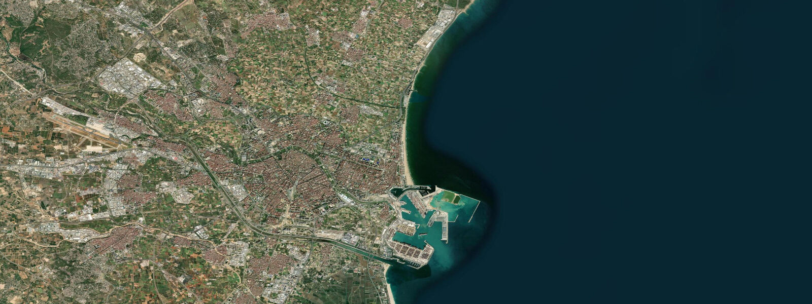
Valencia sits on Spain's central eastern Mediterranean coast at about 39 degrees north, the third-largest Spanish city and the working port that handles the bulk of the western Mediterranean container traffic between the Suez Canal approach and the Rotterdam-Antwerp delta. The city sits on the coastal plain (l'Horta) where the Turia river historically reached the Mediterranean, with the dredged container terminal of the Port of Valencia at the harbour mouth and the long Malvarrosa and Cabanyal beach corridors immediately north. 3 metres and neaps dropping near flat.
The astronomical signal is genuinely tiny because the Mediterranean connects to the Atlantic only through the narrow Strait of Gibraltar. What matters more on a day-to-day basis is meteorological tide. Easterly storms (gota fría / cold-drop low-pressure systems) in autumn can stack water against the coast and lift apparent water level by 30 to 50 centimetres on sustained events.
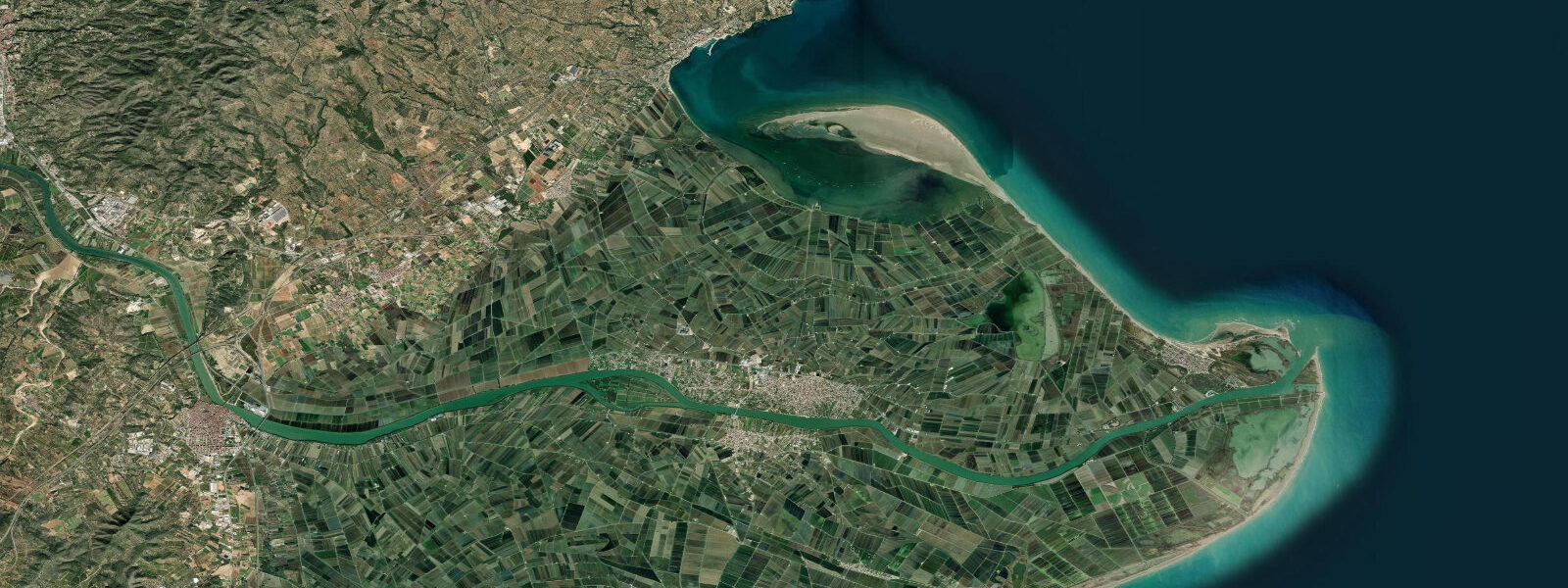
The October 1957 Riada de Valencia flood (3,700 cubic metres per second of Turia discharge through the historic city centre, killing at least 81 people and inundating the Eixample district) drove the most consequential public-works decision in modern Valencian history: the Plan Sur diverted the entire Turia channel south around the city in 1969, and the original riverbed through the city centre was rehabilitated through the 1980s as the 9-kilometre linear Jardín del Turia park system that remains the green lung of the city. The defining ecological feature of the southern coast is the Albufera de Valencia, a 21-square-kilometre brackish lagoon separated from the Mediterranean by a narrow sand bar — the dehesa pine forest — about ten kilometres south of the city centre. The Albufera was historically a tidal estuary and is now a freshwater-dominated lagoon dominated by reed beds and rice cultivation.
The surrounding rice fields provide the bomba and senia rice varieties that make Valencian paella what it is, with the dish born on the lagoon edge as a midday meal for the rice farmers — eel (anguila), garrofó beans, ferraúra and tabella green beans, snails (vaquetes), rabbit, and chicken cooked in the wide flat pan over an open orange-wood fire. Saffron and rosemary finish the dish; rice is bomba or senia, never long-grain. The working port at Valencia handles roughly 5 million TEU per year and ranks among the busiest container ports in the Mediterranean.
The Marina Real Juan Carlos I marina city built for the 32nd America's Cup in 2007 sits between the working port and the Malvarrosa beach corridor. Sailing fleets out of the Real Club Náutico de Valencia, the cruise calls at the cruise terminal, the Albufera lagoon paseo en barca traditional flat-bottomed-boat tours, and the Las Arenas and Malvarrosa beach windows all read the wider weather pattern more than the tide table. Puertos del Estado is the authoritative Spanish tide source and operates the Valencia reference gauge; Open-Meteo Marine drives the gridded predictions on this page.
Tide questions about Valencia
Quick answers to the most common questions about tide times, range, and water access at Valencia.
When is the next high tide at Valencia?
The hero block shows the next high tide at the Valencia port gauge in local Spanish time (CET/CEST with DST). The 7-day table covers all daily highs and lows. The Mediterranean micro-tide pattern produces two small highs and two small lows of comparable size each day, but the astronomical signal is tiny enough that easterly storm events (gota fría) dominate day-to-day water-level variation in autumn.
What's the typical tide range at Valencia?
Mean range at the Valencia port gauge is about 0.2 metres — a small western Mediterranean signal. Spring tides reach close to 0.3 metres and neaps drop near flat. The Mediterranean connects to the Atlantic only through the narrow Strait of Gibraltar, so the astronomical forcing is small enough that the gota fría easterly cold-drop systems in autumn (which can stack water 30 to 50 centimetres above predicted) dominate the working day-to-day signal.
Where do these tide predictions come from?
Open-Meteo Marine, a gridded global ocean model. Useful for planning the Malvarrosa and Las Arenas beach windows, the Albufera lagoon paseo en barca tours, the Marina Real sailing sessions, and the working ferry calendar from the Valencia cruise terminal. For authoritative Spanish tide data, Puertos del Estado operates the Valencia reference gauge and publishes the official tide tables.
What's the Albufera and the paella connection?
The Albufera de Valencia is a 21-square-kilometre brackish lagoon separated from the Mediterranean by a narrow sand bar (the dehesa pine forest) about ten kilometres south of the city centre. The lagoon was historically a tidal estuary and is now a freshwater-dominated lagoon dominated by reed beds and rice cultivation. The surrounding rice fields provide the bomba and senia rice varieties that make Valencian paella what it is — the dish was born on the lagoon edge as a midday meal for the rice farmers, with eel, garrofó beans, ferraúra green beans, snails, rabbit, and chicken cooked in the wide flat pan over an open orange-wood fire.
Is this safe to use for navigation?
No. For piloting in or out of the Port of Valencia container terminals or the Marina Real Juan Carlos I use the Puertos del Estado authoritative tide tables, the Autoridad Portuaria de Valencia pilotage guidance, and the AEMET Spanish meteorological agency marine forecasts during gota fría autumn events. The astronomical signal is small enough that meteorological forcing dominates day-to-day water-level variation.
8-day tide table — Valencia
Heights relative to MSL. Predictions: Open-Meteo Marine (MeteoFrance SMOC, 0.08° grid) — heights relative to MSL (not chart datum / LAT). Model-derived.
| Day | Type | Time | Height |
|---|---|---|---|
| Sun 26 Jul | High | 02:00 | -0.4m |
| Mon 27 Jul | — | ||
| Tue 28 Jul | — | ||
| Wed 29 Jul | — | ||
| Thu 30 Jul | — | ||
| Fri 31 Jul | — | ||
| Sat 01 Aug | — | ||
| Sun 02 Aug | Low | 01:00 | -0.4m |