Los Alcázares tide times
Los Alcázares tide forecast — heights relative to MSL.
Today's tide times for Los Alcázares
Tide times at Los Alcázares on Sunday, 21 June 2026: first high tide at 04:00, first low tide at 14:00. Sunrise 06:41, sunset 21:28.
Tide chart for Los Alcázares
24-hour cosine-interpolated curve around the present moment. Heights relative to MSL. Predictions: Predictions: Open-Meteo Marine (MeteoFrance SMOC, 0.08° grid).
Sun, moon and conditions on Sun 21 Jun
Snapshot at build time — refreshes daily. Sea state from Open-Meteo Marine.
Highs and lows next 7 days
Every predicted high and low for the next week, with the daily tidal coefficient (0–120; higher = bigger swing, > 95 means stronger currents).
Other spots nearby
The three closest curated TideTurtle locations to Los Alcázares, measured by great-circle distance.

Today's solunar windows
Solunar tradition: major periods are the ≈3h windows around moon transit and opposition; minor are ≈2h around moonrise and moonset. Pair with the local tide stage and wind for the best read.
About tides at Los Alcázares
A short guide to the coastline at Los Alcázares — geography, sea state, and what the tide is actually doing under your feet.
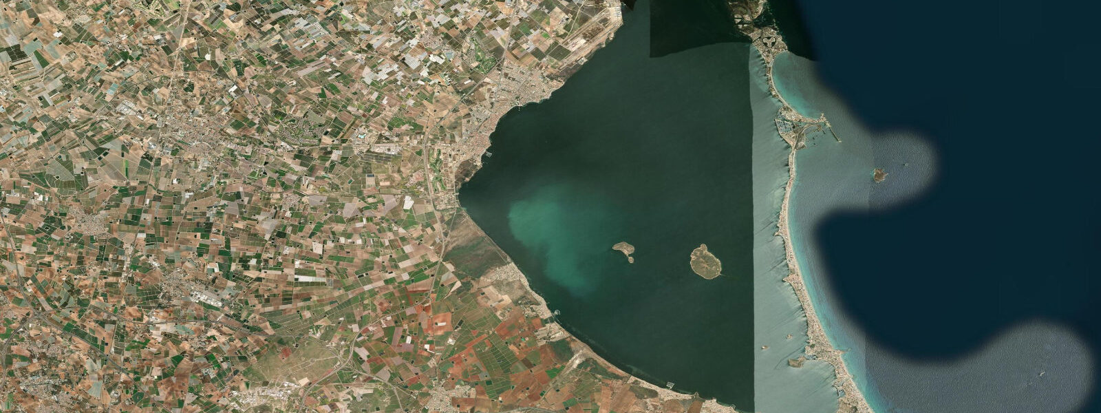
Los Alcázares is a small resort town on the western shore of the Mar Menor, the enclosed saltwater lagoon that sits behind the La Manga barrier strip in southeastern Spain. The lagoon is roughly 22 km north to south and up to 8 km wide, separated from the open Mediterranean by La Manga — a narrow, mostly developed sand barrier that at its narrowest is only 100 m wide. The town faces east across the lagoon toward La Manga; on a clear morning the horizon is the barrier strip rather than open sea, and behind it the Mediterranean is invisible except as a faint shimmer above the rooftops.
The critical fact about the Mar Menor is that it is essentially non-tidal. Water exchange between the lagoon and the Mediterranean occurs only through the Golas — three narrow navigation channels cut through La Manga at Veneziola, Marchamalo, and the southern Encañizadas passage. These channels are narrow enough (the largest is approximately 60 m wide) that the hydraulic resistance prevents meaningful tidal exchange: the water level difference between the lagoon and the open Mediterranean is typically under 0.05–0.10 m, driven more by wind setup than by the astronomical tide. For practical purposes, any activity on the Mar Menor is not subject to tidal planning.
This non-tidal character defines the lagoon's use profile. The water surface is calm even in moderate winds — the fetch across the lagoon is a maximum of 8 km — and depth averages 3–4 m, reaching 7 m at the deepest central point. The shallow, warm, enclosed water heats faster than the open Mediterranean: by July the lagoon surface temperature regularly reaches 30–32°C compared to 26–27°C on the open coast. These conditions created the Mar Menor's original reputation as a therapeutic spa environment (there are hotel and balneotherapy complexes on the waterfront that have operated since the early 20th century) and its current identity as a flat-water sailing, kayaking, and windsurfing venue.
The waterfront at Los Alcázares has a public launch ramp and beach extending roughly 2.5 km along the town's seafront. Windsurfing and catamaran sailing are the traditional disciplines here; thermal and sea-breeze patterns over the lagoon are predictable in summer, with poniente (westerly) and levante (easterly) components cycling through the day. The shallow depth means even in a 20-knot westerly the chop remains short and easily manageable in small craft. Kitesurfing has largely moved to the open Mediterranean coast south of Cartagena because the lagoon is considered too small and busy, but it is practised on the quieter northern sections of the Mar Menor near San Pedro del Pinatar.
The ecological condition of the Mar Menor has deteriorated significantly since 2016. Two major anoxic events (2019 and 2021) caused mass mortality of fish and invertebrates across the lagoon, attributed to agricultural nutrient runoff from the Campo de Cartagena that entered the lagoon through drainage channels and the Golas. The lagoon's restricted exchange with the Mediterranean means that nutrients and organic matter accumulate rather than flushing out. Recovery has been partial; the 2021 event was particularly severe, with dead fish washing onto the Los Alcázares beaches in mass quantities. Current water quality varies by season and position in the lagoon, with the northern and western areas generally better than the south.
For swimming, the lagoon beaches at Los Alcázares are safe and comfortable in settled conditions; the lack of swell, the shallow depth, and the warm temperature make the lagoon a reliable environment for children and non-swimmers. The Playa de los Alcázares town beach has lifeguard coverage in summer. Jellyfish (Rhizostoma pulmo and Cotylorhiza tuberculata) are common in the lagoon in late summer, particularly in years following warm winters.
Tide data on the TideTurtle page for Los Alcázares reflects Open-Meteo Marine modelled predictions for the Mar Menor area. Given the essentially non-tidal nature of the lagoon, these figures indicate sea level trends rather than a meaningful tidal cycle. Timing accuracy is ±45 minutes, height accuracy ±0.2–0.3 m.
Tide questions about Los Alcázares
Quick answers to the most common questions about tide times, range, and water access at Los Alcázares.
Why is the Mar Menor essentially non-tidal, even though it is connected to the Mediterranean?
The Mar Menor connects to the open Mediterranean only through the Golas — three narrow navigation channels cut through La Manga barrier strip. The largest channel is approximately 60 m wide. This narrow opening creates hydraulic resistance that prevents meaningful tidal exchange: the water level difference between the lagoon interior and the Mediterranean side is typically under 0.05–0.10 m per cycle, which is far smaller than even the modest Mediterranean tidal range of 0.2–0.3 m on the open coast. Wind setup across the lagoon produces more variation in surface level than the astronomical tide does. For activity planning, treat the Mar Menor as a still-water lake rather than a tidal body.
What watersports work well on the Mar Menor at Los Alcázares?
Flat-water sailing (catamaran and dinghy), windsurfing, kayaking, and stand-up paddleboarding are the primary disciplines. The combination of a maximum fetch of 8 km, average depth of 3–4 m, and reliable thermal breezes in summer makes the lagoon consistently manageable for beginners and intermediate sailors. Tidal state is irrelevant — the lagoon is non-tidal — and even at 20 knots the chop stays short. Kitesurfing is practised on the quieter northern sections of the lagoon near San Pedro del Pinatar; the southern area around Los Alcázares can be crowded in summer, limiting kite space. Rental and instruction for all disciplines is available from the Los Alcázares waterfront.
What is the current ecological situation in the Mar Menor?
The Mar Menor experienced major anoxic crises in 2019 and 2021, both caused by agricultural nutrient runoff from the Campo de Cartagena entering the lagoon through drainage channels. The restricted exchange with the open Mediterranean means nutrients accumulate; algal blooms deplete oxygen, and fish die in large numbers. The 2021 event was severe, with mass mortalities visible from the Los Alcázares beaches. Recovery has been partial and uneven — northern and western areas of the lagoon have recovered better than the south. Current water quality varies by season; monitoring data is published by the Murcia regional government. Swimming is generally permitted but conditions should be checked locally before entering the water in late summer.
Is the Mar Menor water warm enough for swimming, and when are jellyfish a problem?
The lagoon heats faster than the open Mediterranean because of its shallow depth (average 3–4 m) and restricted circulation. By July the surface temperature reaches 30–32°C, compared to 26–27°C on the open coast. This makes the Mar Menor exceptionally warm for swimming, which is part of its long history as a balneotherapy and therapeutic bathing destination. The downside is that warm, nutrient-rich conditions encourage jellyfish blooms in late summer (August–September). Rhizostoma pulmo (barrel jellyfish, up to 60 cm across) and Cotylorhiza tuberculata (fried-egg jellyfish) are both common; both have mild stings that are an irritant rather than a hazard for most adults.
Can tide predictions for Los Alcázares be used to plan activities on the lagoon?
For the Mar Menor, tidal predictions have very limited practical relevance. The lagoon is effectively non-tidal — the exchange through the Golas channels is so restricted that the astronomical tidal signal is almost entirely damped before reaching the interior. TideTurtle displays Open-Meteo Marine modelled data for this location with accuracy of ±45 minutes and ±0.2–0.3 m, but these figures represent open-water Mediterranean forecasts applied to a lagoon where the actual water level is governed mainly by wind and barometric pressure rather than the tide. For activity planning on the lagoon, wind direction and strength are the critical variables, not the tidal state. The predictions are not suitable for navigation in any context.
7-day tide table — Los Alcázares
Heights relative to MSL. Predictions: Open-Meteo Marine (MeteoFrance SMOC, 0.08° grid) — heights relative to MSL (not chart datum / LAT). Model-derived.
| Day | Type | Time | Height |
|---|---|---|---|
| Sun 21 Jun | High | 04:00 | -0.4m |
| Low | 14:00 | -0.6m | |
| Mon 22 Jun | High | 09:00 | -0.5m |
| Low | 14:00 | -0.6m | |
| Tue 23 Jun | — | ||
| Wed 24 Jun | High | 23:50 | -0.4m |
| Thu 25 Jun | — | ||
| Fri 26 Jun | — | ||
| Sat 27 Jun | Low | 18:00 | -0.5m |