Tarragona tide times
Tarragona tide forecast — heights relative to MSL.
Tide chart for Tarragona
24-hour cosine-interpolated curve around the present moment. Heights relative to MSL. Predictions: Predictions: Open-Meteo Marine (MeteoFrance SMOC, 0.08° grid).
Sun, moon and conditions on Sat 27 Jun
Snapshot at build time — refreshes daily. Sea state from Open-Meteo Marine.
Highs and lows next 7 days
Every predicted high and low for the next week, with the daily tidal coefficient (0–120; higher = bigger swing, > 95 means stronger currents).
Other spots nearby
The three closest curated TideTurtle locations to Tarragona, measured by great-circle distance.
Today's solunar windows
Solunar tradition: major periods are the ≈3h windows around moon transit and opposition; minor are ≈2h around moonrise and moonset. Pair with the local tide stage and wind for the best read.
About tides at Tarragona
A short guide to the coastline at Tarragona — geography, sea state, and what the tide is actually doing under your feet.
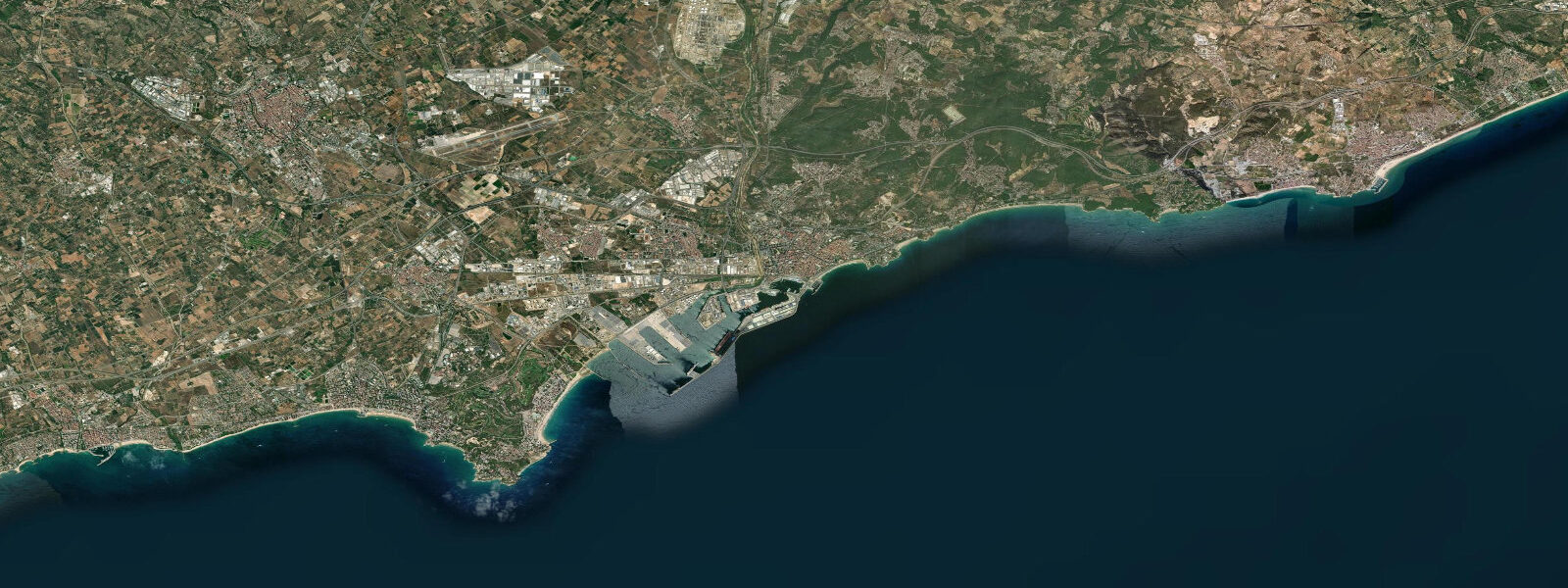
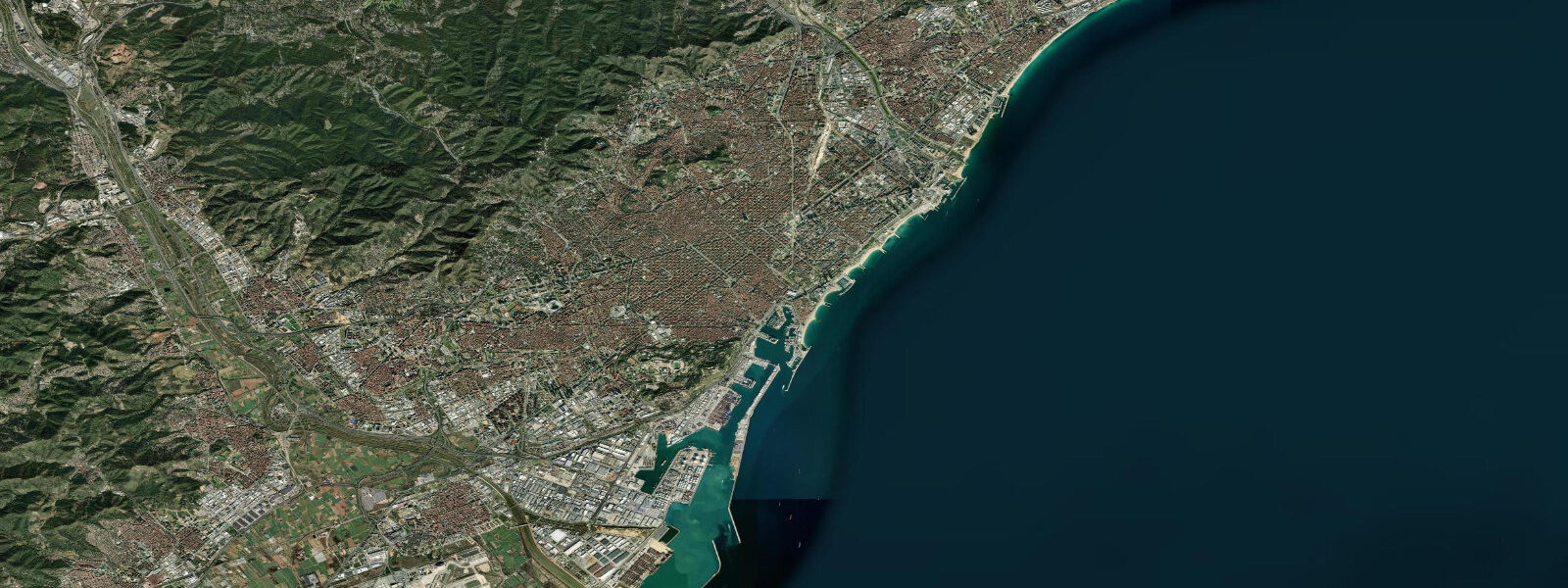
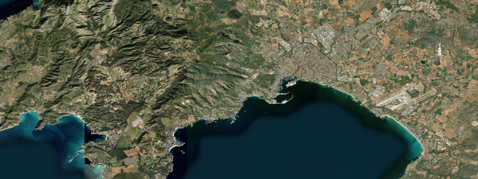
Tarragona stands on a limestone cliff above the Mediterranean coast 100 km southwest of Barcelona, the former capital of Roman Hispania Citerior. The Roman amphitheatre faces the sea directly from the cliff edge, a site unique in the Mediterranean world — an arena built to look out over water, where gladiatorial contests and public executions played out against an open sea backdrop. Today the archaeological park sits between the cliff and the working port, and the beach immediately below — Platja del Miracle — is a 1 km strip of sand in one of the more historically dense coastal settings in Europe.
Spring tidal range at Tarragona is 0.24 m. Like the rest of the Catalan coast, sea level here is controlled by atmospheric pressure and wind far more than by the Moon. The Mediterranean's limited connection to the Atlantic means the tidal forcing is weak; what you see on the tide gauge is mostly barometric pressure responding to weather systems tracking across the Iberian Peninsula. A deep low passing through the Gulf of Lion can temporarily raise sea level at Tarragona by 0.3 m in 6 hours — more than a full tidal cycle compressed into an afternoon.
Platja del Miracle below the amphitheatre is a fine-sand beach with a typical summer programme of beach bars, volleyball nets, and boat rental. The slope is gentle and the swimming is safe in the common southerly and southwesterly swell, which wraps around the port breakwater and arrives diminished at the beach. The port commercial quay to the north provides an additional windbreak. Swell from the southeast or east, generated by levant winds, passes the breakwater more directly and can make the beach uncomfortable.
Costa Daurada extends south from Tarragona's outskirts along a low-lying sandy coast — a series of holiday towns with wide, flat beaches: La Pineda, Salou, Cambrils, and beyond. These beaches are broad enough that the 0.24 m tide range does not significantly alter their character, but they are fully exposed to easterly swell and can turn rough quickly during levant events.
For snorkellers and spearfishers, the rocky sections around Punta de la Mora 5 km north of the city are the standout spots. The headland drops steeply to 15 m, with clean water and decent gorgonian sea fans on the north-facing wall. A local dive club operates from the recreational port at Tarragona marina. Nudist Platja Llarga stretches 3 km north of Punta de la Mora — a long beach accessible on foot or by road, quieter than the town beaches.
The Roman coastal path, the Via Augusta, once ran along this coast and its route is now partly reconstructed as a walking and cycling path. The view from the Balcó del Mediterrani viewpoint at the end of the Rambla Nova — looking south over the amphitheatre, the port, and the open sea — is the canonical Tarragona coastal prospect. Visit at dusk when the limestone buildings catch warm light and the lighthouse on the breakwater begins to flash.
Shore fishing from the rocky points north of the city targets the same species as Barcelona: sargo, grey mullet, sea bass. The rocky bottom around Punta de la Mora also holds dentex at 10–15 m depth. Autumn is locally favoured — September and October see clearer water than summer and fewer boats competing for the fishing grounds.
Families with young children typically prefer Salou or Cambrils 15–20 km south, which have gentler entry profiles and more beach infrastructure. Tarragona's own beaches are fine but more compact, and the port industrial zone immediately north can be visually intrusive.
Tidal predictions here use the Open-Meteo Marine gridded model (±45 minutes on timing, ±0.3 m on height). Not for navigation.
Tide questions about Tarragona
Quick answers to the most common questions about tide times, range, and water access at Tarragona.
Is the beach below the Roman amphitheatre (Platja del Miracle) suitable for families?
Yes — Platja del Miracle is a 1 km fine-sand beach with a gentle slope, lifeguard cover in summer, and beach bars. The port breakwater reduces most southerly and westerly swell, keeping the beach calm on the majority of summer days. The tidal range of 0.24 m does not alter conditions. The main risk is levant swell from the east, which the breakwater blocks less effectively — check the flag system before entering with children. Parking is limited; arriving by train to Tarragona Camp station and walking 10 minutes is often faster than driving.
What are the best snorkelling spots around Tarragona?
The rocky headland at Punta de la Mora, 5 km north of the city centre, is the best accessible snorkelling site. The point drops to 15 m, with clean water and gorgonian fans on the north-facing rock wall. Visibility runs 8–12 m on calm days. The rocky sections immediately north of the amphitheatre also hold fish — bream, mullet, and small wrasse — accessible directly from the Platja del Miracle shoreline. Avoid weekends in July and August when boat traffic makes the outer rocks hazardous for surface snorkellers.
How does atmospheric pressure affect sea level at Tarragona more than the tide?
The inverse barometer effect means that every 1 hPa of low pressure below the standard 1013 hPa raises sea level by approximately 1 cm. A deep Atlantic low tracking across the Iberian Peninsula with a central pressure of 980 hPa can temporarily raise sea level at Tarragona by about 0.33 m — more than a full tidal cycle. Add a sustained onshore wind during the same event and the combined surge can reach 0.4–0.5 m. This meteorological signal dwarfs the astronomical tide (0.24 m spring range) and is the main reason sea level can look unpredictably high during autumn and winter storms.
What fish can I catch from the rocks north of Tarragona city?
The rocky coast north of Tarragona toward Punta de la Mora holds sargo (white sea bream), red mullet, grey mullet, and sea bass from shore. At 10–15 m depth around the headland, dentex are present in autumn and can be targeted with a bottom-fished strip bait or soft lure. No fishing licence is required for shore rod fishing in Catalonia. Spearfishing requires a separate Generalitat de Catalunya licence. September and October are the local preferred months — water clarity improves markedly after summer, and fish density on the rocky sections is at its seasonal peak.
Is there a coastal walking route linking the Roman sites to the beach?
Yes — the section of the Via Augusta coastal path in Tarragona links the Balcó del Mediterrani viewpoint at the end of Rambla Nova, down through the archaeological park, past the amphitheatre, and to Platja del Miracle below. The walk from viewpoint to beach is about 600 m and drops 35 m in elevation. The Balcó del Mediterrani is the best photography vantage point — the amphitheatre, port, and open sea all visible in a single frame. At dusk, the limestone catches warm light and the breakwater lighthouse starts flashing at around sunset minus 20 minutes.
7-day tide table — Tarragona
Heights relative to MSL. Predictions: Open-Meteo Marine (MeteoFrance SMOC, 0.08° grid) — heights relative to MSL (not chart datum / LAT). Model-derived.
| Day | Type | Time | Height |
|---|---|---|---|
| Sat 27 Jun | — | ||
| Sun 28 Jun | Low | 13:00 | -0.6m |
| High | 20:00 | -0.4m | |
| Mon 29 Jun | — | ||
| Tue 30 Jun | — | ||
| Wed 01 Jul | — | ||
| Thu 02 Jul | — | ||
| Fri 03 Jul | Low | 16:00 | -0.6m |
| High | 23:10 | -0.5m | |