
Durban tide times
Durban tide forecast — heights relative to MSL.
Today's tide times for Durban
Tide times at Durban on Friday, 31 July 2026: first low tide at 02:00, first high tide at 04:11, second low tide at 10:16, second high tide at 16:33, third low tide at 22:39. Sunrise 06:42, sunset 17:22.
Tide chart for Durban
24-hour cosine-interpolated curve around the present moment. Heights relative to MSL. Predictions: Predictions: Open-Meteo Marine (MeteoFrance SMOC, 0.08° grid).
Sun, moon and conditions on Fri 31 Jul
Snapshot at build time — refreshes daily. Sea state from Open-Meteo Marine.
Highs and lows next 7 days
Every predicted high and low for the next week, with the daily tidal coefficient (0–120; higher = bigger swing, > 95 means stronger currents).
Other spots nearby
The three closest curated TideTurtle locations to Durban, measured by great-circle distance.
Today's solunar windows
Solunar tradition: major periods are the ≈3h windows around moon transit and opposition; minor are ≈2h around moonrise and moonset. Pair with the local tide stage and wind for the best read.
Cycle dates near Durban
Next spring tide on Sat 01 Aug (range 1.8m). Next neap on Thu 06 Aug.
Spring tides cluster around new and full moons (biggest swings). Neap tides land on quarter moons (smallest swings). See the spring tide and neap tide glossary entries for the why.
About tides at Durban
A short guide to the coastline at Durban — geography, sea state, and what the tide is actually doing under your feet.
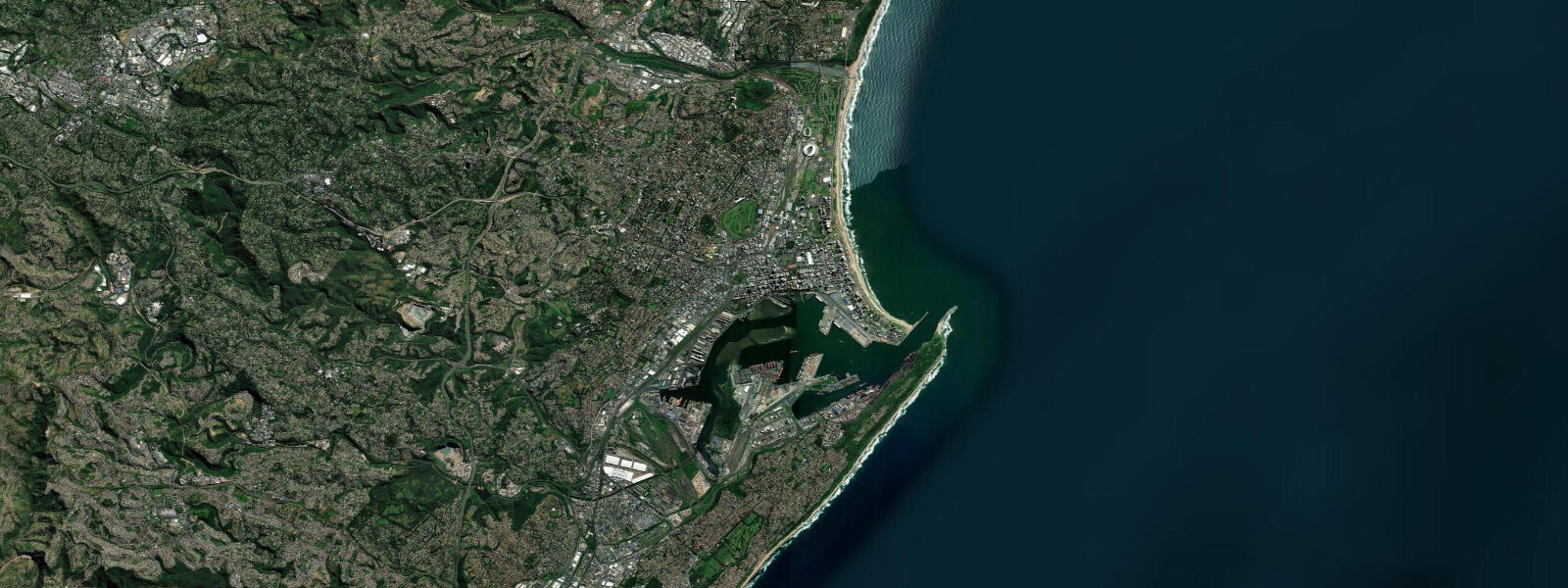
Durban faces northeast into the Indian Ocean from one of the few natural harbour bays on the KwaZulu-Natal coast, a coastline that runs mostly straight and exposed for hundreds of kilometres in either direction. The Bluff — a 60-metre-high wooded headland south of the harbour entrance — deflects the dominant south and southeast swells that arrive from the Southern Ocean, creating calmer water in the Inner Bight and the protected bay that fronts the city. Outside that shelter, the surf runs full-strength, and the Bluff's southern face has produced some of KwaZulu-Natal's most consistent beach and point break conditions for decades.
The tide is semidiurnal, with a mean spring range of approximately 1.6 to 1.9 metres — enough to govern the character of every beach and reef along this coast. At low water on a spring ebb, the beachrock reef at Addington and Ansteys beaches south of the South Pier emerges as a flat, porous limestone platform extending 30 to 60 metres from the waterline. That reef is a calcified former beach, cemented over centuries by groundwater and wave action — it holds rock pools, sea anemones, and small fish in the tide pools at mid-water, and it becomes a fishing platform accessible on foot that would be completely submerged by mid-tide. Knowing the tidal state is the minimum entry requirement for anyone walking the beachrock.
The surf along the Golden Mile beach north of the harbour is beach break, and the tide governs it the way tide governs any beach break: high water brings steeper, hollower waves off a sandbar, low water exposes more of the sandbar and can produce longer, more crumbling waves depending on sand configuration. The swell direction and period matter more than tide for wave quality at any given break, but no experienced surfer here ignores the tide table. The Bluff Point break and Cave Rock further south on the Bluff's outer face are more dependent on swell direction than tidal state, but lower tidal stages expose the reef and rock platforms that make those breaks sharper and more consequential for a fall.
The Umgeni River mouth north of the city centre carries the primary tidal bar that affects the ski-boat launch industry. Ski boats — the open fibreglass centre-console launches used for billfish and tuna charters — exit through the bar in the morning and return in the afternoon, and the bar depth and break character change across the tidal cycle. Experienced ski-boat skippers time the launch to avoid the lowest ebb, when the breaking pattern on the bar becomes unpredictable. The billfish season runs June through August, when the Agulhas Current's cold-water edge sits close inshore south of Durban and concentrates bait; the charter fleet out of Vetch's Pier and the Point area logs significant catches of striped, blue, and black marlin, yellowfin tuna, and dorado across those months.
The Agulhas Current is never far from the story on this coast. South of the Bight it runs at 1.5 to 2.5 knots in a narrow band within a few kilometres of shore, flowing southwest. The current boundary traps warmer water on its inshore side during certain seasons, and the temperature differential concentrates baitfish and, in turn, predators. Fishermen and charter skippers read sea surface temperature maps alongside the tide table. Swimmers stay within the shark-netted beach areas — the KwaZulu-Natal Sharks Board maintains nets and drumlines at the main beaches from Ballito in the north to Umkomaas in the south, serviced by boat patrols that run on tidal schedules, pulling and checking gear through the mid-tidal windows when sea conditions at the nets are most accessible.
Anglers on this coast work the tidal cycles with precision. Rock and surf fishing for shad (elf/bluefish), spotted grunter, and garrick (leervis) is most productive on the push of the incoming tide over a low neap, when fish move inshore on the warming water ahead of the flood. Beach fishing at dawn on a dropping spring tide exposes the beachrock and sandbanks that hold invertebrate food and baitfish in the runoff gullies. Crabbing in the harbour tidal flats near the Bayhead area follows the ebb.
Photographers working this coast find the most useful tidal information is low-water timing at the beachrock sites. The beachrock at Ansteys in early morning light on a spring low makes a specific image — the dark pitted limestone, the wave energy breaking across its outer edge, the city skyline behind — that requires planning around the tide table to access. Drone operators registering flights in the Durban controlled airspace need a SACAA permit regardless of tidal state.
Tide predictions on this page come from Open-Meteo Marine, a global gridded ocean model — model-derived, not a local gauge. Accuracy is typically within plus or minus 45 minutes on timing and 0.2 to 0.3 metres on height. South African National Hydrographer (SANH) tide tables, issued by the South African Navy Hydrographic Office, are the authoritative reference for KwaZulu-Natal coastal timing and should be the check for any commercial operation, bar crossing, or safety-critical timing decision.
Tide questions about Durban
Quick answers to the most common questions about tide times, range, and water access at Durban.
What is the tidal range at Durban?
Mean spring tidal range at Durban is approximately 1.6 to 1.9 metres, placing it in the mesotidal category. Neap ranges are smaller, typically 0.8 to 1.1 metres. The tide is semidiurnal — two high waters and two low waters per day. The difference between spring and neap conditions is significant on this coast: a spring low exposes beachrock reef platforms at Addington and Ansteys that are fully submerged on a neap, and the launch conditions over the Umgeni River tidal bar shift noticeably across the range. Open-Meteo Marine predictions on this page are model-derived, not from a local gauge — typically accurate within plus or minus 45 minutes on timing and 0.2 to 0.3 metres on height. The South African National Hydrographer (SANH) publishes authoritative tide tables for Durban.
When is the best time for shore fishing in Durban?
The most productive windows for beach and rock fishing on the KwaZulu-Natal coast combine two factors: a rising tide pushing over a recent low, and dawn or dusk light when fish are most actively feeding inshore. Shad (bluefish) run in tight schools on the incoming tide through autumn and winter, and garrick (leervis) hunt the shore gutters on the early flood. Spotted grunter work the warmer water of Durban's inner harbour and bay margins through the high-tide period. Spring lows that expose the sandbanks north of the harbour produce good runs in the gullies as the tide turns and floods back. The beachrock reef platforms at Ansteys and Addington are accessible on foot only within two to three hours of low water on a spring — timing those sessions requires checking the table in advance rather than estimating on arrival.
Are the beaches in Durban safe from sharks?
Durban's main beaches along the Golden Mile and extending north to Umhlanga and south to Amanzimtoti are protected by shark nets and drumlines maintained by the KwaZulu-Natal Sharks Board (KZNSB), which has operated this system since 1952. The nets are serviced on tidal cycles — boat crews check and reset them through mid-tidal windows when sea conditions allow safe approach. Swimming within the netted beach areas is significantly lower-risk than outside them, but nets are not a barrier: they are a deterrent by reducing shark populations locally. Rip currents, not sharks, are the more frequent hazard for swimmers. The KZNSB website publishes beach status and sighting reports. Outside the netted areas — at the Bluff beaches, the river mouths, and areas north toward Ballito outside the net zone — standard shark awareness applies.
What is the Agulhas Current and how does it affect Durban?
The Agulhas Current is one of the strongest western boundary ocean currents in the world, flowing southwest along the KwaZulu-Natal coast at 1.5 to 2.5 knots in a band that runs within a few kilometres of shore south of the Durban Bight. It influences the coast in several ways: it concentrates baitfish at its temperature boundaries, which draws the billfish — marlin, sailfish — and tuna that support the offshore charter industry; it creates a current that charter skippers and coastal fishermen navigate around when positioning over productive ground; and its proximity means that water temperatures south of Durban run warmer than latitude alone would predict. The current also plays a role in the shark ecology of the coast, which is partly why the Sharks Board maintains active nets rather than relying on passive deterrents. North of the Durban Bight, the Agulhas influence is weaker and more variable.
Where does the Durban tide data come from?
Tide predictions on this page are generated by Open-Meteo Marine, a free global ocean model — model-derived, not measured at a local gauge. Accuracy is typically within plus or minus 45 minutes on timing and 0.2 to 0.3 metres on height. For authoritative tide data, the South African National Hydrographer (SANH), part of the South African Navy Hydrographic Office, publishes annual tide tables covering Durban and other KwaZulu-Natal ports. SANH data should be the reference for commercial operations, bar crossings, and any decision where precise timing is safety-relevant. The South African Weather Service also incorporates sea-level information into its coastal marine forecasts, which are available through their public website.
8-day tide table — Durban
Heights relative to MSL. Predictions: Open-Meteo Marine (MeteoFrance SMOC, 0.08° grid) — heights relative to MSL (not chart datum / LAT). Model-derived.
| Day | Type | Time | Height |
|---|---|---|---|
| Fri 31 Jul | Low | 02:00 | 0.4m |
| High | 04:11 | 0.9m | |
| Low | 10:16 | -0.8m | |
| High | 16:33 | 0.9m | |
| Low | 22:39 | -0.7m | |
| Sat 01 Aug | High | 04:39 | 0.8m |
| Low | 10:43 | -0.8m | |
| High | 17:04 | 1.0m | |
| Low | 23:07 | -0.7m | |
| Sun 02 Aug | High | 05:09 | 0.8m |
| Low | 11:13 | -0.7m | |
| High | 17:33 | 1.0m | |
| Low | 23:39 | -0.6m | |
| Mon 03 Aug | High | 05:42 | 0.8m |
| Low | 11:42 | -0.7m | |
| High | 18:03 | 0.9m | |
| Tue 04 Aug | Low | 00:14 | -0.6m |
| High | 06:15 | 0.7m | |
| Low | 12:16 | -0.6m | |
| High | 18:40 | 0.8m | |
| Wed 05 Aug | Low | 00:52 | -0.5m |
| High | 06:55 | 0.6m | |
| Low | 12:54 | -0.4m | |
| High | 19:20 | 0.7m | |
| Thu 06 Aug | Low | 01:36 | -0.3m |
| High | 07:42 | 0.5m | |
| Low | 13:46 | -0.3m | |
| High | 20:16 | 0.5m | |
| Fri 07 Aug | Low | 01:00 | -0.1m |