Saint-Louis Beach tide times
Saint-Louis Beach tide forecast — heights relative to MSL.
Today's tide times for Saint-Louis Beach
Tide times at Saint-Louis Beach on Saturday, 4 July 2026: first high tide at 12:00am, first low tide at 05:11am, second high tide at 11:40am, second low tide at 06:00pm. Sunrise 06:38am, sunset 07:41pm.
Tide chart for Saint-Louis Beach
24-hour cosine-interpolated curve around the present moment. Heights relative to MSL. Predictions: Predictions: Open-Meteo Marine (MeteoFrance SMOC, 0.08° grid).
Sun, moon and conditions on Sat 04 Jul
Snapshot at build time — refreshes daily. Sea state from Open-Meteo Marine.
Highs and lows next 7 days
Every predicted high and low for the next week, with the daily tidal coefficient (0–120; higher = bigger swing, > 95 means stronger currents).
Other spots nearby
The three closest curated TideTurtle locations to Saint-Louis Beach, measured by great-circle distance.
Today's solunar windows
Solunar tradition: major periods are the ≈3h windows around moon transit and opposition; minor are ≈2h around moonrise and moonset. Pair with the local tide stage and wind for the best read.
Cycle dates near Saint-Louis Beach
Last spring tide on Sat 04 Jul (range 1.0m). Next neap on Fri 10 Jul.
Spring tides cluster around new and full moons (biggest swings). Neap tides land on quarter moons (smallest swings). See the spring tide and neap tide glossary entries for the why.
About tides at Saint-Louis Beach
A short guide to the coastline at Saint-Louis Beach — geography, sea state, and what the tide is actually doing under your feet.
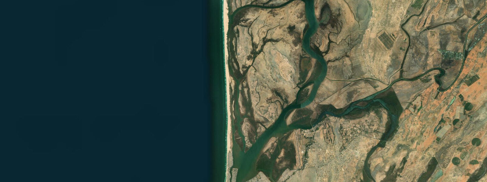
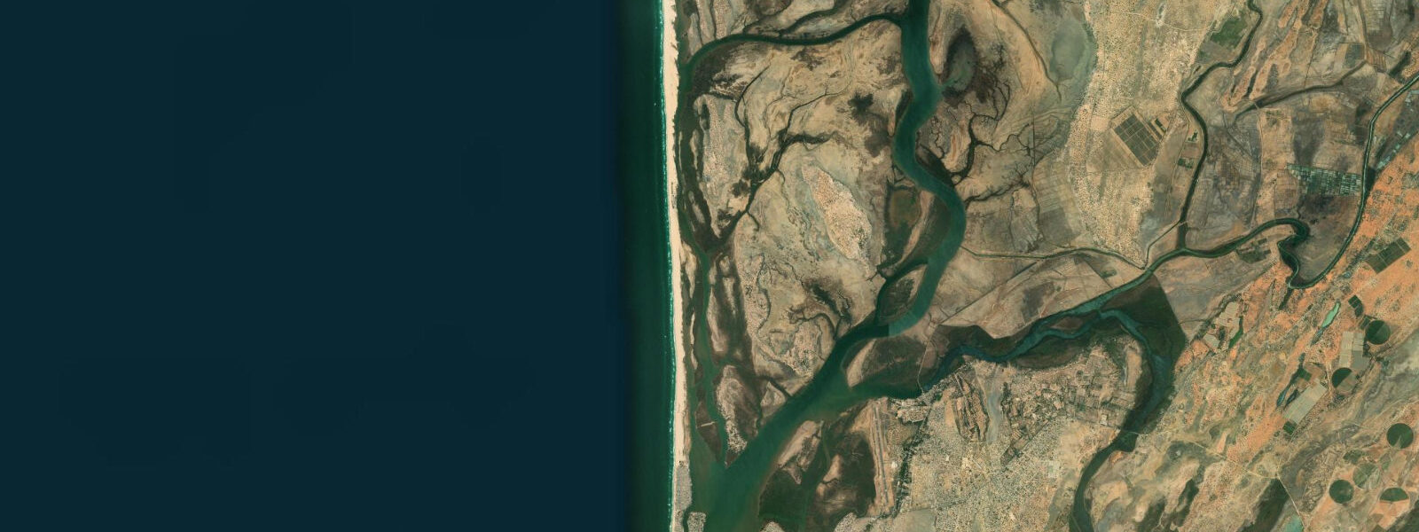
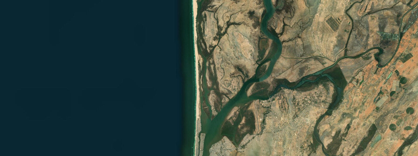
Saint-Louis Beach sits at the tip of the Langue de Barbarie, the thin sand tongue that separates the Senegal River from the Atlantic Ocean just south of the city. The barrier is narrow — in places only 300 metres of sand between ocean and river — and the beach that faces west into the Atlantic is one of the most powerful stretches of unprotected coastline in West Africa. Long-period groundswell wraps around the Cape Verde islands and arrives here with minimal dissipation, running up against the Senegal River's outflow in a constant negotiation of water masses at the river mouth.
This is not a swimming beach for casual visitors. The shore break is heavy even on modest swell days, rip currents form along both flanks of the sand tongue, and the shallow bar in front of the river mouth becomes dangerous at low water when the outflow concentrates through a narrowing channel. But for surfers who came specifically for this energy, the Langue de Barbarie beach breaks are some of the most consistent left-handers on the Senegalese coast.
The peak season runs from November through February, when North Atlantic storm systems push long-period northwest groundswell south and the Harmattan wind — dry, carrying Saharan dust — arrives from the east, offshore, cleaning up the wave faces in the early mornings before the sea breeze fills in after midday. The left-handers along the Langue can run for 50 to 100 metres on a good swell when the sandbank configuration aligns. Tide matters here more than at most West African beach breaks.
The sandbanks migrate with tidal cycles, and the shallow bar in front of the river mouth is genuinely unpredictable at low water — locals who surf here daily know the sandbank layout by memory and adjust their lineups with the state of the tide. The practical planning window is mid-tide rising to the top of the tide; low tide exposes the bar and makes the rip current dynamic more erratic; high tide rounds off the breaking waves and pushes the rips into the channel where they're easier to identify and avoid. 3 m — useful for planning your morning session but not a substitute for watching the water for ten minutes before paddling out.
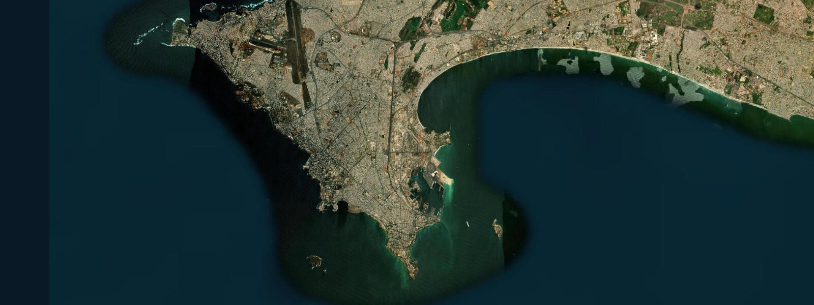
Saint-Louis itself is worth the journey independently of the surf. The island centre — bridges connecting the mainland, Île Saint-Louis, and the Langue — is a UNESCO World Heritage Site, and the colonial-era architecture is genuinely impressive: faded pastel mansions, wrought-iron balconies, the Gouvernance building, and the old bridge that was built in Paris and shipped down. The fish-smoking quarter on the Langue de Barbarie has operated continuously for centuries; the smell of smouldering wood and drying capitaine hits you as soon as you cross the bridge.
The pirogue fleet — brightly painted wooden boats 10 to 15 metres long — launches from the beach most mornings before first light, the fishermen reading the swell and the tide before paddling out. The midday return with the catch, mostly capitaine, barracuda, thiof (white grouper), and bonga, is one of the better spectacles on the Senegal coast. Water temperatures at Saint-Louis sit around 18–22°C in the cooler Canary Current upwelling season from December through March — noticeably cold for an African beach.
A 3/2 mm wetsuit is the right call for extended surf sessions in the heart of the season; a shorty works for October and November when the water is warmer. From Dakar, the beach is reached via the N2 road north, roughly 270 km, four to five hours by sept-place bush taxi. Direct flights from Dakar to Saint-Louis airport cut the trip to under an hour.
Accommodation ranges from colonial-era guesthouses on the island — several have been converted into atmospheric small hotels — to surf camps on the Langue itself.
Tide questions about Saint-Louis Beach
Quick answers to the most common questions about tide times, range, and water access at Saint-Louis Beach.
When is the best time to surf Saint-Louis Beach?
The core surf window runs November through February, when consistent northwest groundswell from North Atlantic storms pushes into the coast and the Harmattan wind provides clean offshore mornings. March and April can still deliver solid surf with less reliable winds. The summer months (June–September) are the rainy and flat season — sea breeze dominates, groundswell is rare, and the beach is quieter. If you're planning a dedicated surf trip, target November to January for the most consistent waves and the most manageable crowds at the limited accommodation on the Langue de Barbarie. Expect water temperatures of 18–21°C in peak season — a 3/2 wetsuit is the right call.
Is Saint-Louis Beach safe for swimming?
Straightforward answer: it's not a safe swimming beach for most visitors. The shore break is heavy even on smaller swell days, the sandbanks shift constantly where the Senegal River mouth meets the ocean, and rip currents run along both sides of the sand tongue. Local fishermen who grew up reading these conditions swim here without issue — they know where the rips run and which sandbar is stable on a given tide. For anyone unfamiliar with the break, the risk is real. If you want to swim in the Saint-Louis area, the calmer estuary side of the Langue de Barbarie is far safer, particularly on an incoming tide when river flow is overcome by the tidal push.
How do tides affect conditions at Saint-Louis Beach?
The tidal range at Saint-Louis is semi-diurnal and moderate — typically 0.8 to 1.3 metres on spring tides, smaller on neaps. The real tidal story here is the interaction between the Atlantic tide and the Senegal River's freshwater discharge. At low tide, the river mouth configuration can amplify rip current strength significantly, pushing more water along the beach than the tide alone would generate. Mid-tide rising is generally the most predictable window for surfing the beach breaks. High tide rounds off the wave shape on the shallower bars. Tide times from Open-Meteo Marine gridded data carry ±45 min accuracy — check local conditions on arrival and adjust your timing accordingly.
What else is there to do near Saint-Louis beyond the beach?
Saint-Louis island itself is the main draw — UNESCO-listed colonial architecture, the Gouvernance building, and the Faidherbe Bridge connecting the island to the mainland. The Parc National des Oiseaux du Djoudj, 60 km north, is one of Africa's premier bird sanctuaries: three million migratory birds winter here, including pelicans, flamingos, and spoonbills. Organised pirogue excursions from the beach run most days in season — the sunset trips upriver through the Langue de Barbarie national park are particularly good. Fishing trips on traditional wooden pirogues can be arranged through guesthouses on the island, targeting capitaine, barracuda, and occasional dorado offshore.
How do I get to Saint-Louis Beach from Dakar?
By road it's around 270 km on the N2 via Thiès and Louga — expect four to five hours by sept-place bush taxi (shared Peugeot station wagon, the standard intercity transport) from Dakar's Gare Routière de Pompiers. Direct departures most mornings from around 6 am. Air Senegal runs occasional domestic flights between Dakar and Saint-Louis Airports (Léopold Sédar Senghor to Saint-Louis), cutting travel to under an hour; check schedules as frequency varies by season. From the city, the Langue de Barbarie and the beach are a 15-minute taxi ride or short moto-taxi trip across the bridge to the Langue.
7-day tide table — Saint-Louis Beach
Heights relative to MSL. Predictions: Open-Meteo Marine (MeteoFrance SMOC, 0.08° grid) — heights relative to MSL (not chart datum / LAT). Model-derived.
| Day | Type | Time | Height |
|---|---|---|---|
| Sat 04 Jul | High | 00:00 | 0.3m |
| Low | 05:11 | -0.4m | |
| High | 11:40 | 0.6m | |
| Low | 18:00 | -0.4m | |
| Sun 05 Jul | High | 00:03 | 0.4m |
| Low | 05:55 | -0.4m | |
| High | 12:19 | 0.6m | |
| Low | 18:43 | -0.4m | |
| Mon 06 Jul | High | 00:43 | 0.4m |
| Low | 06:36 | -0.3m | |
| High | 13:00 | 0.6m | |
| Low | 19:25 | -0.3m | |
| Tue 07 Jul | High | 13:42 | 0.6m |
| Low | 20:13 | -0.3m | |
| Wed 08 Jul | High | 02:23 | 0.4m |
| Low | 08:18 | -0.2m | |
| High | 14:42 | 0.5m | |
| Low | 21:10 | -0.3m | |
| Thu 09 Jul | High | 15:47 | 0.4m |
| Low | 22:10 | -0.3m | |
| Fri 10 Jul | High | 04:40 | 0.4m |
| Low | 10:47 | -0.2m | |
| High | 17:12 | 0.4m | |
| Low | 23:00 | -0.3m |