Langue de Barbarie tide times
Langue de Barbarie tide forecast — heights relative to MSL.
Today's tide times for Langue de Barbarie
Tide times at Langue de Barbarie on Saturday, 4 July 2026: first high tide at 12:00am, first low tide at 05:08am, second high tide at 11:43am, second low tide at 06:00pm. Sunrise 06:38am, sunset 07:41pm.
Tide chart for Langue de Barbarie
24-hour cosine-interpolated curve around the present moment. Heights relative to MSL. Predictions: Predictions: Open-Meteo Marine (MeteoFrance SMOC, 0.08° grid).
Sun, moon and conditions on Sat 04 Jul
Snapshot at build time — refreshes daily. Sea state from Open-Meteo Marine.
Highs and lows next 7 days
Every predicted high and low for the next week, with the daily tidal coefficient (0–120; higher = bigger swing, > 95 means stronger currents).
Other spots nearby
The three closest curated TideTurtle locations to Langue de Barbarie, measured by great-circle distance.
Today's solunar windows
Solunar tradition: major periods are the ≈3h windows around moon transit and opposition; minor are ≈2h around moonrise and moonset. Pair with the local tide stage and wind for the best read.
Cycle dates near Langue de Barbarie
Last spring tide on Sat 04 Jul (range 1.0m). Next neap on Fri 10 Jul.
Spring tides cluster around new and full moons (biggest swings). Neap tides land on quarter moons (smallest swings). See the spring tide and neap tide glossary entries for the why.
About tides at Langue de Barbarie
A short guide to the coastline at Langue de Barbarie — geography, sea state, and what the tide is actually doing under your feet.
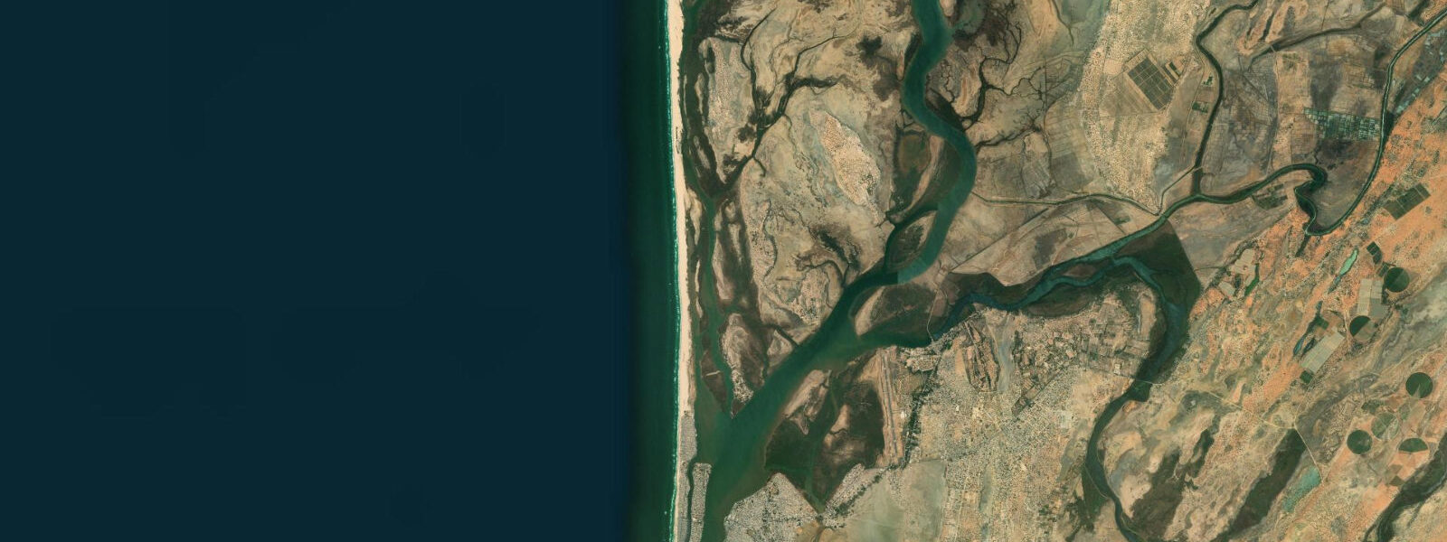
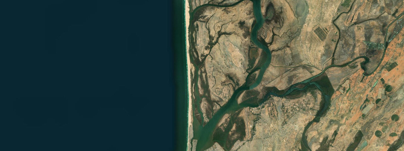
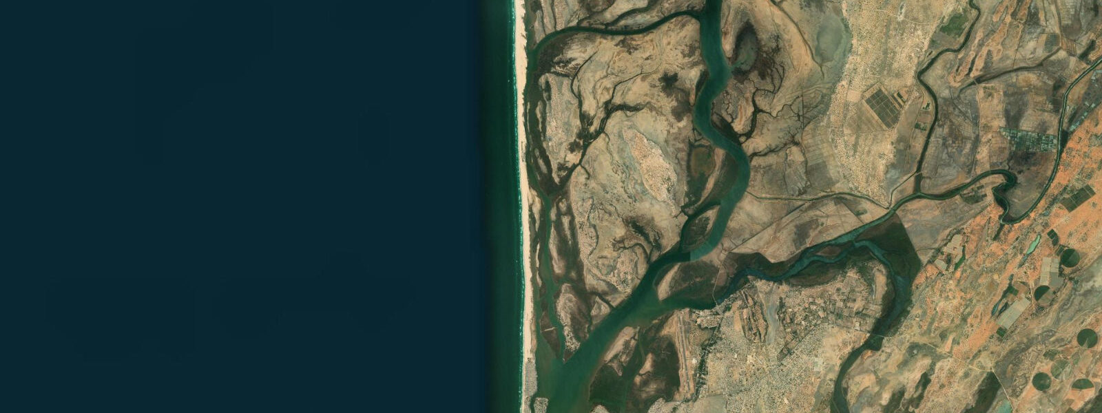
The Langue de Barbarie is the narrow sand spit that separates Saint-Louis from the Atlantic Ocean — a thin tongue of land, rarely more than 300 metres wide, running for roughly 25 kilometres from the mouth of the Senegal River southward along the coast. On its western face: open Atlantic. On its eastern face: the tidal lagoon and the islands of Saint-Louis. The spit is geologically active and politically charged: it has been artificially breached twice in recent decades to manage flood risk during high-river events, and the location of the river mouth changes with each major flood season.
The National Park of the Langue de Barbarie sits at the southern end of the spit, protecting coastal wetland habitat that supports enormous breeding colonies of grey herons, great white pelicans, and royal terns, along with the only sea turtle nesting beaches in this section of the Senegal coast. The park entrance is at the village of Mouit, reached by boat from Saint-Louis or by a sandy track from the south.
Tide data for the Langue de Barbarie comes from Open-Meteo Marine. Timing accuracy is ±45 minutes; height accuracy is ±0.2 to 0.3 metres. The Atlantic face of the spit experiences the same semidiurnal tidal signal as Saint-Louis: spring range 1.2 to 1.8 metres. The lagoon face is more protected and tidal exchange is partially regulated by the width of the spit and the position of the river mouth breach.
For beach users on the Atlantic face, tide stage determines the width of usable beach dramatically. At low water on a spring tide, the sand flat can extend 80 to 120 metres seaward of the vegetation line. At high water, the beach narrows significantly — in some erosion-prone sections the waves reach the vegetation fringe at high spring tide. The Atlantic face has persistent longshore drift from north to south; swimming here requires awareness of both the surf and the lateral current.
Sea turtle nesting occurs on the Atlantic beach from approximately May through August, with loggerhead and leatherback turtles recorded. The park's management team monitors nests and can arrange guided night visits during peak nesting months. Turtle emergence happens at night, typically on high-tide or post-high-tide cycles when wet sand extends furthest up the beach profile.
For birdwatchers, the lagoon side is the productive zone: pelicans and herons feed on the lagoon shallows on an outgoing tide, when fish are concentrated in shallowing water. Flat-bottomed pirogues from Saint-Louis are the standard access method; most guides know the best viewing channels. The lagoon is navigable at all tide stages, though some shallow channels become very restricted at low water.
For photographers, the spit provides unique compositions: Atlantic surf on one side, still lagoon on the other, with no land visible except the spit itself from many vantage points. Late afternoon light from the west illuminates the Atlantic face. Drone photography above the waterline is used by nature photographers here, though the national park section requires permits.
The ecological significance of the lagoon behind the Langue de Barbarie extends beyond the national park. The entire lagoon system, covering several hundred square kilometres from the Saint-Louis island south to the Loumpoul area, is a productive wetland supporting commercial fisheries for mullet, tilapia, and shrimp. Women from the villages along the lagoon edge use traditional basket traps in the shallow waters to catch shrimp and small fish; this small-scale fishery supplies local markets and is an important food security resource for lagoon-side communities.
The sand dynamics of the spit require context. The Langue de Barbarie's position and dimensions have shifted multiple times in living memory. Before the 2003 breach, the spit extended further south and the river mouth was 25 kilometres from Saint-Louis. The breach relocated the effective mouth to 5 kilometres south of the city. This shift dramatically changed travel time by boat between Saint-Louis and the southern lagoon, and altered the wave and current patterns on the Atlantic face of the spit north and south of the new mouth. The 2020 breach further modified the system. Visitors should expect that any photograph or map of the spit older than five years may not accurately reflect current conditions.
The southern end of the spit, within the national park, supports nesting colonies of mixed tern species alongside the pelicans and herons. The vegetation fringe — Casuarina windbreak trees planted in some sections to stabilise the dunes — provides nesting habitat for several passerine species. The interplay between managed and natural vegetation on the spit is a running theme in the park management discussion.
Tide questions about Langue de Barbarie
Quick answers to the most common questions about tide times, range, and water access at Langue de Barbarie.
What is the Langue de Barbarie National Park?
The Langue de Barbarie National Park protects the southern section of the sand spit and adjacent lagoon wetlands, covering approximately 20 square kilometres. It was established in 1976 and is one of Senegal's smaller but ecologically significant parks. Key features include nesting colonies of grey herons, great white pelicans, and royal terns on the lagoon side, and sea turtle nesting beaches on the Atlantic face. Entry is by boat from Saint-Louis. The park office at Mouit can arrange guided lagoon tours by pirogue; wildlife spotting is best on morning outgoing tides when birds feed actively on the shallowing lagoon flats.
What is the tidal range on the Langue de Barbarie?
The Atlantic face of the Langue de Barbarie experiences semidiurnal tides with a spring range of 1.2 to 1.8 metres. On the lagoon side, tidal exchange is partially damped by the geometry of the spit and the position of the river mouth breach; effective range on the lagoon face is lower, typically 0.6 to 1.0 metres at springs. Tide predictions here use Open-Meteo Marine's global model, with ±45 minutes on timing and ±0.2 to 0.3 metres on height. River flood events in August through October can significantly exceed modelled water levels on the lagoon side.
When do sea turtles nest on the Langue de Barbarie?
Nesting season runs roughly May through August. Loggerhead and leatherback turtles have both been recorded on the Atlantic beach, with leatherbacks (the larger and more impressive of the two) more common in the earlier part of the season. Females emerge at night, typically on or just after the high tide when the wet sand zone extends furthest up the beach. The national park team monitors active nests; guided night visits during peak season can be arranged through the Saint-Louis tourism operators or directly at the park office. Avoid flashlights and direct disturbance — disorientation of nesting females is a documented risk.
Has the Langue de Barbarie been artificially breached?
The spit was artificially breached in 2003 to relieve flooding pressure on Saint-Louis during an exceptionally high Senegal River flood event. The breach was intended to be small and temporary; it widened significantly and relocated the effective river mouth several kilometres southward. A second artificial breach was made in 2020 during another major flood. Each breach changes the sediment dynamics of the entire spit: sections north of the breach accrete while sections south erode. This means the beach morphology changes year to year, and the landmarks in historical photographs may no longer match current conditions.
How do I get from Saint-Louis to the Langue de Barbarie?
The northern section of the spit is walkable from the Guet Ndar fishing quarter via the beach. For the national park at the southern end, the standard access is by pirogue across the lagoon from Saint-Louis — a journey of 20 to 40 minutes. Numerous operators in Saint-Louis offer half-day and full-day tours to the park. The sandy track from the south (via Mouit village) is accessible by 4WD but requires local knowledge of the route state. Most visitors take the pirogue option, which also allows observation of the lagoon bird life en route.
7-day tide table — Langue de Barbarie
Heights relative to MSL. Predictions: Open-Meteo Marine (MeteoFrance SMOC, 0.08° grid) — heights relative to MSL (not chart datum / LAT). Model-derived.
| Day | Type | Time | Height |
|---|---|---|---|
| Sat 04 Jul | High | 00:00 | 0.3m |
| Low | 05:08 | -0.4m | |
| High | 11:43 | 0.6m | |
| Low | 18:00 | -0.4m | |
| Sun 05 Jul | High | 00:02 | 0.4m |
| Low | 05:55 | -0.4m | |
| High | 12:16 | 0.6m | |
| Low | 18:37 | -0.4m | |
| Mon 06 Jul | High | 00:42 | 0.4m |
| Low | 06:36 | -0.3m | |
| High | 12:57 | 0.6m | |
| Low | 19:25 | -0.3m | |
| Tue 07 Jul | High | 13:42 | 0.6m |
| Low | 20:12 | -0.3m | |
| Wed 08 Jul | High | 02:23 | 0.4m |
| Low | 08:18 | -0.2m | |
| High | 14:37 | 0.5m | |
| Low | 21:10 | -0.3m | |
| Thu 09 Jul | High | 15:40 | 0.4m |
| Low | 22:07 | -0.3m | |
| Fri 10 Jul | High | 04:40 | 0.4m |
| Low | 10:40 | -0.2m | |
| High | 17:10 | 0.4m | |
| Low | 23:00 | -0.3m |