Guet Ndar tide times
Guet Ndar tide forecast — heights relative to MSL.
Today's tide times for Guet Ndar
Tide times at Guet Ndar on Saturday, 4 July 2026: first high tide at 12:00am, first low tide at 05:11am, second high tide at 11:40am, second low tide at 06:00pm. Sunrise 06:38am, sunset 07:42pm.
Tide chart for Guet Ndar
24-hour cosine-interpolated curve around the present moment. Heights relative to MSL. Predictions: Predictions: Open-Meteo Marine (MeteoFrance SMOC, 0.08° grid).
Sun, moon and conditions on Sat 04 Jul
Snapshot at build time — refreshes daily. Sea state from Open-Meteo Marine.
Highs and lows next 7 days
Every predicted high and low for the next week, with the daily tidal coefficient (0–120; higher = bigger swing, > 95 means stronger currents).
Other spots nearby
The three closest curated TideTurtle locations to Guet Ndar, measured by great-circle distance.
Today's solunar windows
Solunar tradition: major periods are the ≈3h windows around moon transit and opposition; minor are ≈2h around moonrise and moonset. Pair with the local tide stage and wind for the best read.
Cycle dates near Guet Ndar
Last spring tide on Sat 04 Jul (range 1.0m). Next neap on Fri 10 Jul.
Spring tides cluster around new and full moons (biggest swings). Neap tides land on quarter moons (smallest swings). See the spring tide and neap tide glossary entries for the why.
About tides at Guet Ndar
A short guide to the coastline at Guet Ndar — geography, sea state, and what the tide is actually doing under your feet.
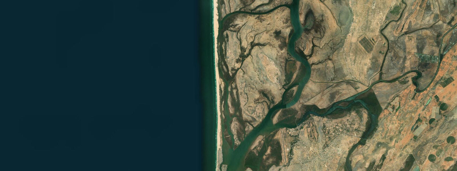
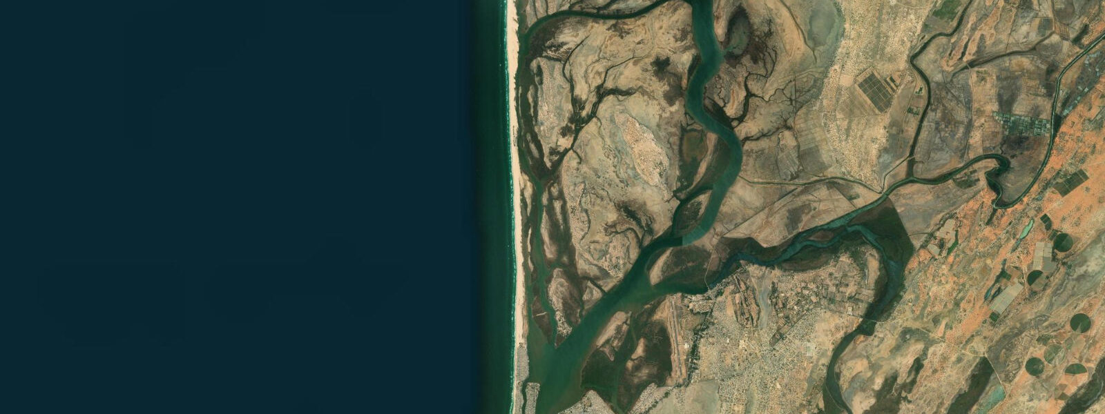
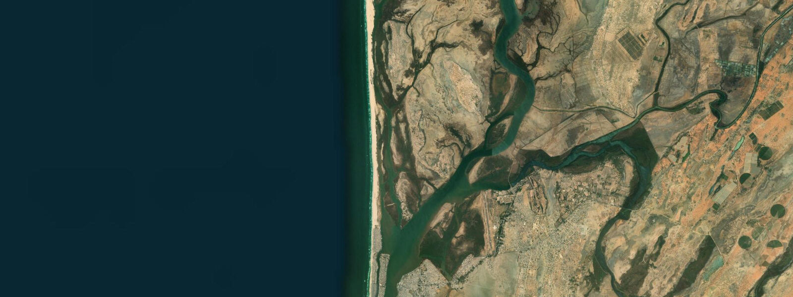
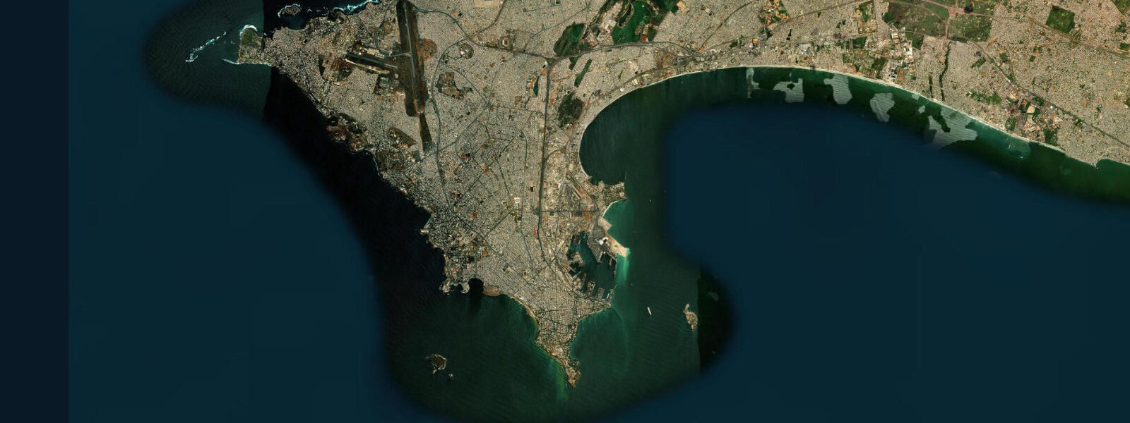
Guet Ndar is the fishing quarter of Saint-Louis, packed onto the northern tip of the narrow island that separates the Senegal River from the Atlantic. It is one of the most densely populated areas in West Africa and one of the most visually concentrated fishing harbours on the continent: at any given morning, several thousand pirogues in vivid yellow, blue, and orange are pulled up on the beach or launched through the Atlantic surf. Locals call it the "fishing army", and the description is not hyperbole.
The site sits at the convergence of three water bodies: the Atlantic Ocean immediately to the west, the Senegal River mouth to the north, and the tidal Langue de Barbarie lagoon to the east. This convergence creates a hydraulic environment that is more complex than a standard tidal station. The Senegal River discharge, which varies seasonally from near-zero in the dry season to heavy flood pulses after August rains, interacts with the Atlantic tidal signal to produce water levels that diverge significantly from pure tidal prediction.
Tide data for Guet Ndar comes from Open-Meteo Marine's global gridded model. Timing accuracy is ±45 minutes; height accuracy is ±0.2 to 0.3 metres. The Atlantic face of the Langue de Barbarie experiences semidiurnal tides with a typical spring range of 1.2 to 1.8 metres. The river-side (lagoon side) responds to tides more sluggishly and is further modulated by river stage.
For the fishermen of Guet Ndar, tidal phase is a life-and-death variable. The surf launch — pushing a loaded 10-metre pirogue through breaking Atlantic waves — is substantially safer on a high-tide approach when the beach gradient is gentler and the break occurs further offshore. On low-tide launches, the waves break on a shallower gradient closer to shore, with more turbulent backwash. Fishermen read the wave period and height as much as the tide, but a rising tide is the preferred departure condition.
For beach visitors and photographers, the pirogue launch spectacle happens from approximately 05:00 to 08:00 daily. The scale is extraordinary: hundreds of boats launching in sequence through the Atlantic surf, organized by informal spatial convention among the fishing families. The best photographic position is from the beach ridge on the Langue de Barbarie, looking north toward the launch zone, in the first hour after sunrise.
For anglers, the current rip at the Senegal River mouth — roughly 1 kilometre north of Guet Ndar — is a productive zone on the outgoing tide. Barracuda, African threadfin (capitaine), and jack species hold in the mixing zone where fresh and salt water meet. Access is by pirogue hire from the beach; wading or shore fishing in the river mouth zone is not recommended due to currents.
Saint-Louis itself, immediately east of Guet Ndar on the island, is a UNESCO World Heritage city with colonial-era architecture. The combination of urban heritage and fishing community makes this one of the more layered coastal stops in West Africa. Water temperature runs 18 to 22°C in the cold-upwelling season (December to May) and 26 to 28°C from August through October.
The economic structure of Guet Ndar's fishing community is built around the boat owners (who finance and maintain the pirogues), the navigators (who lead the crews), and the fish processors (largely women, who handle curing and market distribution). The processed bonga shad — smoked and dried — travels from the Guet Ndar market to destinations across Senegal and neighbouring countries. The volume is substantial: on a productive day, thousands of pirogues returning means thousands of tonnes of fish entering the processing chain.
Saint-Louis, the UNESCO World Heritage city immediately to the east, provides a broader context for the Guet Ndar coastal experience. The city is the former colonial capital of French West Africa, built on a narrow river island between 1659 and the early 20th century. The Pont Faidherbe, an iron bridge designed by Gustave Eiffel's company and installed in 1897, still carries traffic between the mainland, the island, and the Langue de Barbarie. Walking the island's streets takes visitors through colonial-era architecture that houses contemporary markets, restaurants, and guesthouses.
The interaction between the Senegal River, the Atlantic, and the changing sand spit is a living geological and hydrological experiment. Seasonal shifts in the river mouth position change the wave environment at the Guet Ndar surf launch, sometimes improving and sometimes worsening the launch conditions from year to year. The fishermen read these changes and adjust their launch zones accordingly.
Tide questions about Guet Ndar
Quick answers to the most common questions about tide times, range, and water access at Guet Ndar.
What is the tidal range at Guet Ndar?
The Atlantic coast at Guet Ndar experiences semidiurnal tides with a spring range of 1.2 to 1.8 metres, typical for the Senegal Atlantic coast. Neap range drops to 0.5 to 0.8 metres. Predictions here use the Open-Meteo Marine global model, with ±45 minutes timing accuracy and ±0.2 to 0.3 metres height accuracy. The actual water level at the Senegal River mouth also reflects river discharge — during the August to September rainy season, river flood pulses can push water levels up by 0.3 to 0.5 metres above the tidal prediction, particularly on the lagoon side.
When do the fishermen launch their pirogues at Guet Ndar?
The main launch window runs from about 05:00 to 08:00 daily, with peak activity in the hour before sunrise. Fishermen prefer a rising tide for the Atlantic surf launch — the wave break is further offshore and the beach gradient is gentler, making it easier to push a loaded pirogue through the surf zone. Returns typically occur in the late morning and early afternoon. The beach is most photogenic during the launch window, when hundreds of brightly painted pirogues are in various stages of preparation, launch, or landing.
Is it safe to swim at Guet Ndar beach?
Swimming at Guet Ndar's Atlantic beach is not recommended. The surf is a working industrial zone — pirogues launch and land continuously during fishing hours — and the wave energy on this exposed Atlantic coast is substantial. The beach gradient produces dumping surf on lower tides. The lagoon side (Langue de Barbarie) is calmer but is used by fishing boats and has variable water quality given the urban density of Guet Ndar. For swimming, Saint-Louis visitors typically go to the beach strips north of the fishing quarter or to the hotel beaches on the Langue de Barbarie.
How does the Senegal River affect tides here?
The Senegal River mouth sits approximately 1 kilometre north of Guet Ndar. During the dry season (November through June), river discharge is low and the tidal signal dominates water levels throughout the estuary. From August through October, the upper Senegal watershed receives heavy rainfall; the resulting flood discharge pushes against the incoming tide and can raise water levels in the river and lagoon by 0.3 to 0.5 metres above the astronomical tide prediction. This seasonal interaction affects navigation in the river mouth and the lagoon channels behind the island.
What is the best time of year to visit Saint-Louis?
November through May is the dry season and the most comfortable period for visiting. December through February brings cool, dry harmattan conditions with temperatures of 20 to 25°C. March through May sees warming temperatures and occasional fog from the cold Atlantic upwelling — the Canary Current brings cold water to the surface offshore, and sea temperatures can drop to 18°C, which also brings excellent productivity for the fishery. June through October is hot and humid, with the rainy season peaking August through September. The pirogue launching spectacle is year-round and independent of season.
7-day tide table — Guet Ndar
Heights relative to MSL. Predictions: Open-Meteo Marine (MeteoFrance SMOC, 0.08° grid) — heights relative to MSL (not chart datum / LAT). Model-derived.
| Day | Type | Time | Height |
|---|---|---|---|
| Sat 04 Jul | High | 00:00 | 0.3m |
| Low | 05:11 | -0.4m | |
| High | 11:40 | 0.6m | |
| Low | 18:00 | -0.4m | |
| Sun 05 Jul | High | 00:03 | 0.4m |
| Low | 05:55 | -0.4m | |
| High | 12:19 | 0.6m | |
| Low | 18:43 | -0.4m | |
| Mon 06 Jul | High | 00:43 | 0.4m |
| Low | 06:36 | -0.3m | |
| High | 13:00 | 0.6m | |
| Low | 19:25 | -0.3m | |
| Tue 07 Jul | High | 13:42 | 0.6m |
| Low | 20:13 | -0.3m | |
| Wed 08 Jul | High | 02:23 | 0.4m |
| Low | 08:18 | -0.2m | |
| High | 14:42 | 0.5m | |
| Low | 21:10 | -0.3m | |
| Thu 09 Jul | High | 15:47 | 0.4m |
| Low | 22:10 | -0.3m | |
| Fri 10 Jul | High | 04:40 | 0.4m |
| Low | 10:47 | -0.2m | |
| High | 17:12 | 0.4m | |
| Low | 23:00 | -0.3m |