Dakar tide times
Dakar tide forecast — heights relative to MSL.
Today's tide times for Dakar
Tide times at Dakar on Saturday, 27 June 2026: first low tide at 12:00am, first high tide at 06:56am, second low tide at 01:00pm, second high tide at 07:15pm. Sunrise 06:43am, sunset 07:42pm.
Tide chart for Dakar
24-hour cosine-interpolated curve around the present moment. Heights relative to MSL. Predictions: Predictions: Open-Meteo Marine (MeteoFrance SMOC, 0.08° grid).
Sun, moon and conditions on Sat 27 Jun
Snapshot at build time — refreshes daily. Sea state from Open-Meteo Marine.
Highs and lows next 7 days
Every predicted high and low for the next week, with the daily tidal coefficient (0–120; higher = bigger swing, > 95 means stronger currents).
Other spots nearby
The three closest curated TideTurtle locations to Dakar, measured by great-circle distance.
Today's solunar windows
Solunar tradition: major periods are the ≈3h windows around moon transit and opposition; minor are ≈2h around moonrise and moonset. Pair with the local tide stage and wind for the best read.
Cycle dates near Dakar
Next spring tide on Fri 03 Jul (range 1.1m). Last neap on Sat 27 Jun.
Spring tides cluster around new and full moons (biggest swings). Neap tides land on quarter moons (smallest swings). See the spring tide and neap tide glossary entries for the why.
About tides at Dakar
A short guide to the coastline at Dakar — geography, sea state, and what the tide is actually doing under your feet.
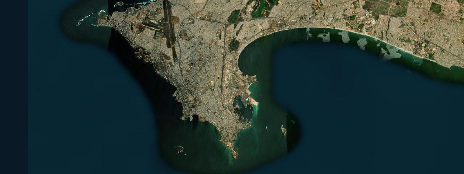
Dakar occupies the westernmost point of mainland Africa — the Cap-Vert peninsula thrusts 35 km into the Atlantic at 14.7°N, separating the open ocean to the west from the protected bight to the north and south, and making Dakar's geography unlike any other major African city. The city is the peninsula, and the peninsula is defined by the interplay of Atlantic tides, trade wind seas, and the cold upwelling water of the Canary Current that makes the sea off Cap-Vert consistently cooler and more productive than the surrounding tropical ocean.
The tidal regime at Dakar is semidiurnal with a spring range of approximately 1.8 m, driven by the full Atlantic tidal wave arriving from the southwest. Two clear highs and two lows per day, with modest diurnal inequality. The Corniche Ouest road — running along the Atlantic cliff face on the peninsula's western side — follows a shoreline where the full Atlantic tidal cycle is visible in the rock ledges and the surge channels: at spring low water, ledges exposed 1.5 m above normal high tide sit dry and accessible; at spring high water, spray reaches the road wall on any swell. The Corniche Ouest is one of West Africa's defining urban coastal drives: 8 km of clifftop road, breaking Atlantic surf 30 m below, the Almadies lighthouse at the western tip, and the open ocean to the Americas.
The Port of Dakar on the peninsula's eastern (sheltered) side is one of West Africa's major freight terminals, handling container traffic for Senegal, Mali, and the Sahel interior. The port is accessible at all tide stages for deep-draft vessels — the sheltered bight east of the peninsula provides calm water independent of the Atlantic swell that batters the western face. Passenger ferry services to the islands of the Dakar bight — Gorée, and seasonal services to Casamance in the south — depart from the passenger terminal adjacent to the main port.
Gorée Island, 3 km east of Dakar by ferry, is the most visited UNESCO World Heritage Site in West Africa. The island served as a slave-trade entrepôt from the 16th through the 18th century; the Maison des Esclaves (House of Slaves) with its Door of No Return, the colonial-era architecture, and the island's car-free, bougainvillea-covered streets draw visitors continuously. The 20-minute ferry crossing from the Gare Maritime runs hourly; tides have no practical effect on the crossing or the island access, as the ferry landing operates in sheltered water. At low tide, the rock shelf on Gorée's northern side exposes, and local children swim and fish from the exposed ledges.
For anglers, Dakar offers some of the best shore-based fishing access in West Africa. The rocky headlands at the Almadies point (the true westernmost tip of Africa) hold large concentrations of trevally, barracuda, and various jack species on the ebb tide. Local shore anglers work these points with lures and live bait, timing the session for the first two hours of ebb when current maximises at the headland. The upwelling driven by the Canary Current keeps these waters cold and productive year-round; sea surface temperatures off Cap-Vert run 18–22°C, 3–5°C cooler than the average for the latitude.
Paddlers and small-boat operators working the eastern bight have calm conditions most of the year — the peninsula completely shields this water from the Atlantic swell. The tidal flat at the Hann Bay southeast of the city centre exposes at low water on spring tides, and the mangrove fringe at the southern base of the peninsula is navigable by kayak. The western, Atlantic-facing shore is too exposed for recreational paddling except in the flat conditions of June through September.
Photographers working Dakar find three distinct subjects: the Atlantic cliff face of the Corniche Ouest at sunrise, when the easterly light catches the breaking swell and the rocky shore below; the Gorée Island colonial streetscapes in the soft morning light before the ferry crowds arrive; and the working fishing beach at Soumbédioune on the Corniche Est, where pirogues are beached in tight rows and the morning fish market operates from 05:00 to 09:00. The Soumbédioune beach is best photographed on a flooding tide as the pirogues return — the scene of brightly painted wooden boats landing through gentle surf while the market buyers wait is one of the definitive images of Dakar.
All tide predictions for Dakar come from the Open-Meteo Marine gridded model. Timing accuracy is ±45 minutes; height accuracy is ±0.3 m above Chart Datum.
Tide questions about Dakar
Quick answers to the most common questions about tide times, range, and water access at Dakar.
What is the tidal range at Dakar and how does it affect the Corniche Ouest shoreline?
Dakar has a spring tidal range of approximately 1.8 m. On the rocky Atlantic face of the Corniche Ouest, the full range is visible: at spring low water, rock ledges 1.5 m above the normal waterline sit dry and accessible, while at spring high water with swell, spray reaches the road wall. The eastern, sheltered bight side of the peninsula has the same tidal amplitude but no wave action. The Port of Dakar operates in the sheltered bight and is accessible at all tide stages for commercial vessels.
How do I get to Gorée Island from Dakar?
Ferries to Gorée Island depart from the Gare Maritime (passenger terminal) adjacent to the main port in central Dakar. The crossing is approximately 20 minutes. Ferries run roughly every hour from 06:15 to 23:00; the last return from Gorée varies seasonally. Tides have no effect on the crossing — the route is in sheltered water and the ferry landing operates at all tide stages. The island is car-free; accommodation is available for overnight stays. Morning arrivals on the first or second ferry avoid the peak tourist crowd that arrives with cruise ship tenders later in the day.
Why is the sea off Dakar cooler than expected for the latitude?
The Canary Current flows southward along the West African coast and drives coastal upwelling as it deflects westward around Cap-Vert. Deep, cold, nutrient-rich Atlantic water rises to the surface, keeping sea surface temperatures at 18–22°C off Dakar — 3–5°C cooler than typical tropical ocean at 14–15°N. This upwelling drives high fish productivity (supporting Dakar's large artisanal fishing fleet) and a persistent coastal fog in the cooler months (December through February). Swimmers expecting warm tropical water are often surprised by the cold.
Where is the best shore fishing at Dakar?
The Almadies headland at the true western tip of Cap-Vert is the premier shore fishing location. Rocky points here hold trevally, barracuda, and jack on the ebb tide, with the first two hours of ebb being the most productive as current builds at the headland. Local shore anglers use lures and live bait; the rocky ledges provide multiple casting positions at different tidal stages. The Corniche Ouest cliff base is inaccessible except at spring low water, when the exposed rock shelf below the road provides additional fishing positions. Soumbédioune beach is better suited to watching the commercial catch land than to sport fishing.
What is the Soumbédioune fishing beach and when should I visit?
Soumbédioune is the main artisanal fishing beach on the Corniche Est, on the sheltered eastern side of the Cap-Vert peninsula. Brightly painted pirogues beach here in tight rows; the associated fish market runs from approximately 05:00 to 09:00 as fleets return from overnight and early-morning runs. The best time to visit is at dawn on a flooding tide, when the boats land through the gentle surf and buyers and sellers negotiate directly on the sand. Photography is welcomed but a small payment to individual fishermen before photographing them is expected and appropriate.
7-day tide table — Dakar
Heights relative to MSL. Predictions: Open-Meteo Marine (MeteoFrance SMOC, 0.08° grid) — heights relative to MSL (not chart datum / LAT). Model-derived.
| Day | Type | Time | Height |
|---|---|---|---|
| Sat 27 Jun | Low | 00:00 | -0.5m |
| High | 06:56 | 0.4m | |
| Low | 13:00 | -0.4m | |
| High | 19:15 | 0.3m | |
| Sun 28 Jun | Low | 01:06 | -0.5m |
| High | 07:40 | 0.4m | |
| Low | 13:43 | -0.4m | |
| High | 19:50 | 0.3m | |
| Mon 29 Jun | Low | 01:42 | -0.5m |
| High | 08:16 | 0.4m | |
| Tue 30 Jun | Low | 02:24 | -0.5m |
| High | 08:55 | 0.5m | |
| Low | 15:02 | -0.5m | |
| High | 21:03 | 0.3m | |
| Wed 01 Jul | Low | 03:00 | -0.5m |
| Thu 02 Jul | High | 10:02 | 0.6m |
| Low | 16:11 | -0.5m | |
| High | 22:13 | 0.4m | |
| Fri 03 Jul | Low | 04:04 | -0.5m |
| High | 10:39 | 0.6m | |
| Low | 16:50 | -0.4m | |
| High | 23:00 | 0.4m |