Ziguinchor Bay tide times
Ziguinchor Bay tide forecast — heights relative to MSL.
Tide chart for Ziguinchor Bay
24-hour cosine-interpolated curve around the present moment. Heights relative to MSL. Predictions: Predictions: Open-Meteo Marine (MeteoFrance SMOC, 0.08° grid).
Sun, moon and conditions on Sat 04 Jul
Snapshot at build time — refreshes daily. Sea state from Open-Meteo Marine.
Highs and lows next 7 days
Every predicted high and low for the next week, with the daily tidal coefficient (0–120; higher = bigger swing, > 95 means stronger currents).
Other spots nearby
The three closest curated TideTurtle locations to Ziguinchor Bay, measured by great-circle distance.
Today's solunar windows
Solunar tradition: major periods are the ≈3h windows around moon transit and opposition; minor are ≈2h around moonrise and moonset. Pair with the local tide stage and wind for the best read.
About tides at Ziguinchor Bay
A short guide to the coastline at Ziguinchor Bay — geography, sea state, and what the tide is actually doing under your feet.
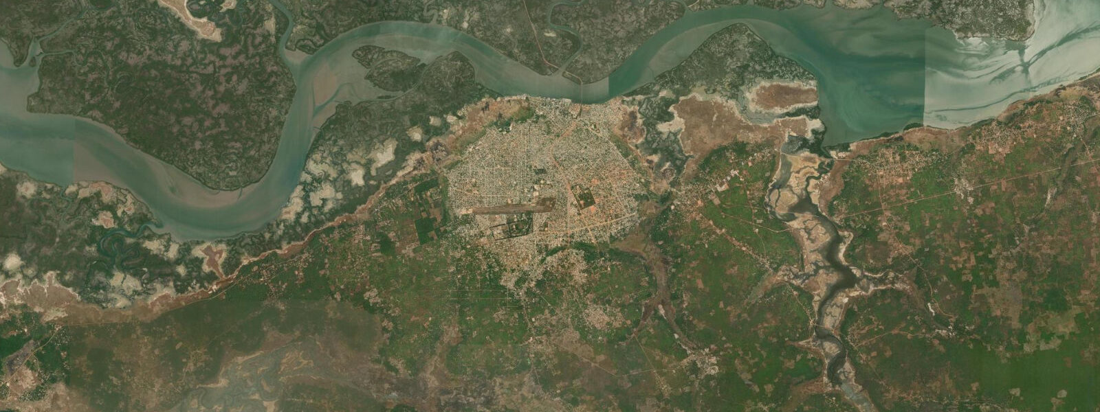
Ziguinchor sits 60 kilometres up the Casamance River from the Atlantic, but it reads entirely as a coastal town — the river is tidal this far inland, the boats on the waterfront move with the current, and the mangrove channels that branch off the main river carry the estuary's rhythms deep into the forest. The bay and waterfront are the functional centre of Ziguinchor: dugout canoes and wooden motor launches run passengers and cargo between the town and the villages upriver and downriver; the fish market at the quayside operates from before dawn with the catch brought in overnight; and the smell of the river on a falling tide — vegetative, salt-edged, slightly fermented from the mangrove leaf litter — is the smell of the town in the early morning. This is not a beach destination.
The riverbanks are mangrove-edged, the water is brown with tannins from the surrounding forest, and the Atlantic coast is 60 km downstream at Cap Skirring. What Ziguinchor offers instead is access to the Casamance as a living estuarine system in a way that no other town on the river can provide — the market, the waterfront culture, the Jola villages reachable by canoe, and the mangrove creek system that branches south from the main channel toward the Basse-Casamance National Park. The tidal signal at Ziguinchor is semi-diurnal and visible to anyone watching the waterfront over the course of a day.
Spring tides push a significant volume of water 60 kilometres upriver, raising the river level against the quay walls and flushing the mangrove channels to navigable depth. At the spring high tide, the lower mangrove roots are completely submerged and small boats can traverse channels that are exposed mudflats at low water. At the ebb, the mudflats re-emerge and the wading birds — great egret, grey heron, African spoonbill, black-crowned night heron — work the shallows methodically.
The best window for kayaking the mangrove creeks is the two hours before high tide to one hour after: the channels are flooded, the water level is rising or at maximum, and the current is manageable. 3 m accuracy for this location — adequate for planning, but the river mouth and seasonal freshwater discharge add uncertainty at the 60-km point. Confirm timing with local guides before committing to a long mangrove transit that depends on specific water depths.
Ziguinchor is the regional capital of Casamance and the cultural centre of the Jola people, one of West Africa's largest ethnic groups. The morning market near the Grand Mosque is excellent — smoked fish, fresh palm oil in bottles, seasonal fruit, woven textiles in traditional Jola patterns. The artisan quarter along the main road produces the carved wooden masks, woven baskets, and leather goods that Casamance is known for; prices are significantly lower than in Dakar.
The cuisine leans heavily on what the river provides: tiebou dieun made with thiof or bonga caught that morning is the standard lunch, and the palm-wine tapping trade means local bar culture is distinct and accessible. Wildlife guides based in the town can organise trips into Basse-Casamance National Park — forest buffalo, western chimpanzee, Nile monitor, and Jentink's duiker are recorded species, though sightings require patience and early departures before 6 am. Getting to Ziguinchor from Dakar: the Dakar–Ziguinchor ferry (Aline Sitoé Diatta) is the atmospheric choice — an overnight crossing arriving at the waterfront in the heart of town.
The domestic flight is faster, around one hour from Blaise Diagne. From Cap Skirring, 80 km by shared taxi on the main road, around 90 minutes. The Casamance political situation has historically created travel advisories; as of 2025 the main tourist corridor is stable — check current FCDO or State Department guidance before your trip.
Tide questions about Ziguinchor Bay
Quick answers to the most common questions about tide times, range, and water access at Ziguinchor Bay.
What activities are available at Ziguinchor Bay?
Kayaking the mangrove channels is the headline activity, best done from two hours before high tide when the creeks are navigable and birdlife is concentrated at the water margin. Guided boat trips up the Casamance River toward the villages of Enampor and Affiniam are easy to arrange from the waterfront — most run in the morning before the afternoon sea breeze kicks up chop on the river. Birding is exceptional: African fish eagle, grey-headed kingfisher, and yellow-billed stork are regulars. The waterfront fish market is worth a dawn visit. Ziguinchor town itself has a well-preserved colonial quarter, a lively artisan market, and some of the best home-cooking restaurants in Casamance.
How do tides affect kayaking and boat trips on the Casamance River?
The Casamance estuary is strongly tidal as far as Ziguinchor and beyond. Spring tides flood the mangrove channels to navigable depth and make the wetland accessible; low tide drops the water level enough to strand a kayak in the mud in the shallower creeks. Plan any mangrove excursion to start on the incoming tide — the two hours before high water give you slack and rising water, the safest window. On the river itself, a falling tide means current runs toward the sea; an incoming tide pushes upriver. Experienced guides read the tide naturally and adjust departure times accordingly. Confirm the day's high tide time with your guide before setting out; Open-Meteo predictions carry ±45 min accuracy, so local knowledge is the tiebreaker.
Is Ziguinchor suitable for families?
Yes, within reasonable expectations for a small West African city rather than a resort. The boat trips and mangrove kayak excursions are suitable for children who can sit still in a boat for 90 minutes. The waterfront area is safe and lively in daylight hours. The guesthouses and small hotels in Ziguinchor are generally clean and family-friendly; the larger places have outdoor space. Food is straightforward — tiebou dieun (fish and rice), chicken yassa, fresh juice. There are no swimming beaches in Ziguinchor itself; the nearest Atlantic beach is 60 km west at Cap Skirring. For a family combining cultural visit, wildlife, and beach, the Ziguinchor + Cap Skirring pairing works well over 4–5 days.
What wildlife can I see in the Casamance near Ziguinchor?
The mangrove estuary immediately around the town holds West African manatees (elusive, most often spotted in the quieter southern channels), Nile monitor lizards on the banks, and a rich bird community including malachite kingfisher, pied kingfisher, African fish eagle, and various herons and egrets. Basse-Casamance National Park, 30 km south, holds larger mammals including forest buffalo, red river hog, and western chimpanzee in the denser forest patches — access requires a guide and early departure. The Cercopan sanctuary equivalent in Casamance focuses on primates; green monkeys and western red colobus are visible on the forest edges around the Niamone research station east of the park.
Is it safe to visit Ziguinchor and Casamance?
The main tourist corridor — Ziguinchor, Cap Skirring, the coastal road between them, and the Basse-Casamance National Park — has been stable and safe for travellers for most of the past decade. The long-running Casamance separatist conflict (MFDC) is concentrated in rural forest areas well away from the tourist routes and has been in a low-intensity phase. However, the situation is variable and advisories do shift. Always check your government's current travel advisory (FCDO for UK, State Department for US, Auswärtiges Amt for Germany) before travelling. The standard precaution applies: stick to the main tourist routes, travel with a local guide for any forest or off-road excursion, and register with your embassy if staying more than a few days.
0-day tide table — Ziguinchor Bay
Heights relative to MSL. Predictions: Open-Meteo Marine (MeteoFrance SMOC, 0.08° grid) — heights relative to MSL (not chart datum / LAT). Model-derived.
| Day | Type | Time | Height |
|---|