Kitava Island, Milne Bay tide times
Kitava Island, Milne Bay tide forecast — heights relative to MSL.
Today's tide times for Kitava Island, Milne Bay
Tide times at Kitava Island, Milne Bay on Saturday, 4 July 2026: first low tide at 11:50am. Sunrise 06:09am, sunset 05:47pm.
Tide chart for Kitava Island, Milne Bay
24-hour cosine-interpolated curve around the present moment. Heights relative to MSL. Predictions: Predictions: Open-Meteo Marine (MeteoFrance SMOC, 0.08° grid).
Sun, moon and conditions on Sat 04 Jul
Snapshot at build time — refreshes daily. Sea state from Open-Meteo Marine.
Highs and lows next 7 days
Every predicted high and low for the next week, with the daily tidal coefficient (0–120; higher = bigger swing, > 95 means stronger currents).
Other spots nearby
The three closest curated TideTurtle locations to Kitava Island, Milne Bay, measured by great-circle distance.
Today's solunar windows
Solunar tradition: major periods are the ≈3h windows around moon transit and opposition; minor are ≈2h around moonrise and moonset. Pair with the local tide stage and wind for the best read.
About tides at Kitava Island, Milne Bay
A short guide to the coastline at Kitava Island, Milne Bay — geography, sea state, and what the tide is actually doing under your feet.
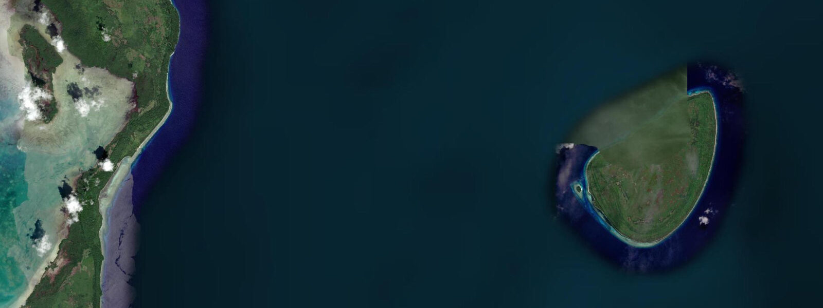
Kitava is the easternmost island of the Trobriand group, sitting at the far eastern edge of the Milne Bay Province island chain approximately 80 kilometres north of the Papuan mainland. It is a raised coral island — elevated above sea level by tectonic uplift rather than volcanic action — with a narrow fringing reef and a small population living a largely subsistence life. The island entered the academic record through Bronisław Malinowski's fieldwork between 1915 and 1918, which produced the founding texts of modern anthropology including Argonauts of the Western Pacific. Malinowski documented the Kula Ring exchange network here in more detail than anywhere else; Kitava was a principal node in the ceremonial shell exchange that linked the Milne Bay islands.
The Kula Ring still operates. The mwali (white shell armbands) and soulava (red shell necklaces) still move between partner communities across the Milne Bay island groups in patterns of ceremonial exchange that create and maintain social relationships across hundreds of kilometres of open water. Kitava's canoes — the traditional lakatoi style with outrigger and crab-claw sail — still make the Kula voyages, though outboard-equipped fibreglass hulls increasingly share the trading routes. The exchange itself is what matters: the objects, the obligations, and the social bonds they create.
Tide data for Kitava is derived from Open-Meteo Marine's global ocean model. Timing accuracy is within ±45 minutes; height accuracy is within ±0.2 to 0.3 metres. The Trobriand group experiences mixed semidiurnal tides with a spring range of 1.5 to 2.5 metres. The raised coral limestone that forms Kitava's land mass creates a steeply shelving fringing reef that drops quickly to 10 to 15 metres at the reef edge — different from the gradual lagoon slopes of the atoll-type islands to the south. On low spring tides, the reef flat on the shoreward side of the fringing reef can dry to exposed limestone, limiting beach and inshore access.
For divers, the fringing reef off Kitava's northern and eastern faces has the best structure. The reef slope drops from the crest at 0.5 to 1.5 metres to 20 to 30 metres with hard coral coverage reflecting the island's relatively low fishing and dive pressure. Larger reef fish species — coral trout, grouper, Napoleon wrasse — are present in greater abundance than at more regularly dived sites in Milne Bay. The clearest water, best visibility, and most settled conditions are in the May to October dry season; visibility on the outer slope runs 20 to 30 metres in this period.
For snorkellers, the accessible window is the two hours around high water. The fringing reef crest at low tide is at 0.3 to 0.8 metres — too shallow for comfortable snorkelling and damaging to coral. At high tide the crest is at 1.2 to 2.0 metres, giving a clear snorkel window from the beach to the reef edge. Coral cover on the shallow sections is in good condition by Milne Bay standards. The fish assemblage on the reef top is diverse: parrotfish, surgeonfish, wrasse, and occasional reef sharks at the drop-off.
The logistics of reaching Kitava reflect its position on the fringe of the Trobriand group. Flights connect Losuia (the main Trobriand airstrip on Kiriwina Island, 50 kilometres west) to Gurney Airport at Alotau and to Port Moresby. From Losuia, boats travel to Kitava — the journey takes 2 to 4 hours by motorised dinghy depending on sea state. There is no scheduled boat service; charter is the only option. Some Alotau-based dive operators run liveaboard itineraries through the Trobriand group that include Kitava.
Accommodation on Kitava is village-level homestay, not tourist lodge. The island has no commercial accommodation, no electricity grid, and no regular fuel supply. Visitors arriving independently need to be fully self-sufficient or to arrange stay through community connections — typically via the Losuia-based tourism office or through one of the Trobriand Island tourism cooperatives. This is one of the genuinely remote destinations accessible within Papua New Guinea's island network.
The diet on Kitava became an unexpected subject of nutritional science in the 1990s when Swedish researchers documented near-zero rates of cardiovascular disease and diabetes in the population — attributed to the traditional high-root-crop, no-processed-food diet. The Kitava Study is a well-cited dataset in paleo and evolutionary nutrition research. The island's food system — yams, taro, fish, coconut — is unchanged by commerce.
Tide questions about Kitava Island, Milne Bay
Quick answers to the most common questions about tide times, range, and water access at Kitava Island, Milne Bay.
What is the Kula Ring and is it still active at Kitava?
The Kula Ring is a ceremonial exchange network connecting communities across the Milne Bay island groups through the reciprocal gifting of two types of shell valuables: mwali (white shell armbands, travelling counterclockwise) and soulava (red shell necklaces, travelling clockwise). The exchange creates and maintains social relationships across hundreds of kilometres of open water; it is not trade in the commercial sense but a social institution with deep obligations and ritual significance. Kitava was one of the principal nodes documented by Malinowski in 1915 to 1918 and the system remains active today. Kula voyages still depart from Kitava using outrigger canoes and, increasingly, outboard-equipped fibreglass hulls.
What are the tidal conditions at Kitava and how do they affect reef access?
Kitava experiences mixed semidiurnal tides with a spring range of 1.5 to 2.5 metres. The fringing reef around the island's raised coral limestone shoreline shallows sharply: the reef crest drops to 0.3 to 0.8 metres at low water, making it too shallow for comfortable snorkelling and risking coral contact. At high tide the crest is at 1.2 to 2.0 metres — the two hours around the predicted high give the best window for reef snorkelling and beach access. Tide data is from Open-Meteo Marine — accuracy ±45 minutes and ±0.2 to 0.3 metres. Low spring tides can expose the reef flat and limestone shelf to air.
How do I get to Kitava from Port Moresby?
The route runs Port Moresby to Alotau (Gurney Airport) or Port Moresby to Losuia (Kiriwina Island airstrip) by Air Niugini. From Losuia, a chartered motorised dinghy to Kitava takes 2 to 4 hours depending on sea state; there is no scheduled service. The journey requires advance arrangement. Alotau-based dive operators running liveaboard itineraries through the Trobriand group are the most practical access route for divers and snorkellers — the operator handles the logistics, fuel supply, and community clearances. Independent travellers can arrange village stay through the Losuia tourism office or Trobriand Island tourism cooperatives.
Is there accommodation on Kitava?
There is no commercial accommodation on Kitava. The island has no tourist lodge, no electricity grid, and no regular fuel or supply line. Village homestay is the only option for visitors staying on the island, and this requires arrangement through community channels — the Losuia tourism office on Kiriwina, or direct contact with community representatives known to the PNG tourism board. Visitors arriving without prior arrangement will find a warm reception in most cases but cannot expect accommodation to materialise. Dive liveaboard itineraries that include Kitava handle all accommodation on board, avoiding the homestay logistics.
What diving conditions can I expect on the Kitava fringing reef?
The fringing reef on Kitava's northern and eastern faces offers reef slope diving from the crest at 0.5 to 1.5 metres down to 20 to 30 metres. Fish populations reflect the low dive and fishing pressure: coral trout, grouper, and Napoleon wrasse are more abundant than at heavily visited Milne Bay sites. Visibility on the outer slope runs 20 to 30 metres in the May to October dry season, dropping to 15 to 20 metres in the wet season. Tidal current on the reef slope is light to moderate — the fringing reef geometry does not concentrate flow the way a channel passage does. There are no established dive moorings; vessels anchor in sand patches at the reef edge.
8-day tide table — Kitava Island, Milne Bay
Heights relative to MSL. Predictions: Open-Meteo Marine (MeteoFrance SMOC, 0.08° grid) — heights relative to MSL (not chart datum / LAT). Model-derived.
| Day | Type | Time | Height |
|---|---|---|---|
| Sat 04 Jul | Low | 11:50 | 0.3m |
| Sun 05 Jul | High | 03:18 | 1.1m |
| Mon 06 Jul | — | ||
| Tue 07 Jul | — | ||
| Wed 08 Jul | — | ||
| Thu 09 Jul | — | ||
| Fri 10 Jul | — | ||
| Sat 11 Jul | Low | 09:00 | 0.2m |