Carenero Island, Bocas del Toro tide times
Carenero Island, Bocas del Toro tide forecast — heights relative to MSL.
Today's tide times for Carenero Island, Bocas del Toro
Tide times at Carenero Island, Bocas del Toro on Friday, 19 June 2026: first low tide at 10:54am. Sunrise 06:10am, sunset 06:50pm.
Tide chart for Carenero Island, Bocas del Toro
24-hour cosine-interpolated curve around the present moment. Heights relative to MSL. Predictions: Predictions: Open-Meteo Marine (MeteoFrance SMOC, 0.08° grid).
Sun, moon and conditions on Fri 19 Jun
Snapshot at build time — refreshes daily. Sea state from Open-Meteo Marine.
Highs and lows next 7 days
Every predicted high and low for the next week, with the daily tidal coefficient (0–120; higher = bigger swing, > 95 means stronger currents).
Other spots nearby
The three closest curated TideTurtle locations to Carenero Island, Bocas del Toro, measured by great-circle distance.
Today's solunar windows
Solunar tradition: major periods are the ≈3h windows around moon transit and opposition; minor are ≈2h around moonrise and moonset. Pair with the local tide stage and wind for the best read.
Cycle dates near Carenero Island, Bocas del Toro
Next spring tide on Fri 19 Jun (range 0.4m). Next neap on Sun 21 Jun.
Spring tides cluster around new and full moons (biggest swings). Neap tides land on quarter moons (smallest swings). See the spring tide and neap tide glossary entries for the why.
About tides at Carenero Island, Bocas del Toro
A short guide to the coastline at Carenero Island, Bocas del Toro — geography, sea state, and what the tide is actually doing under your feet.
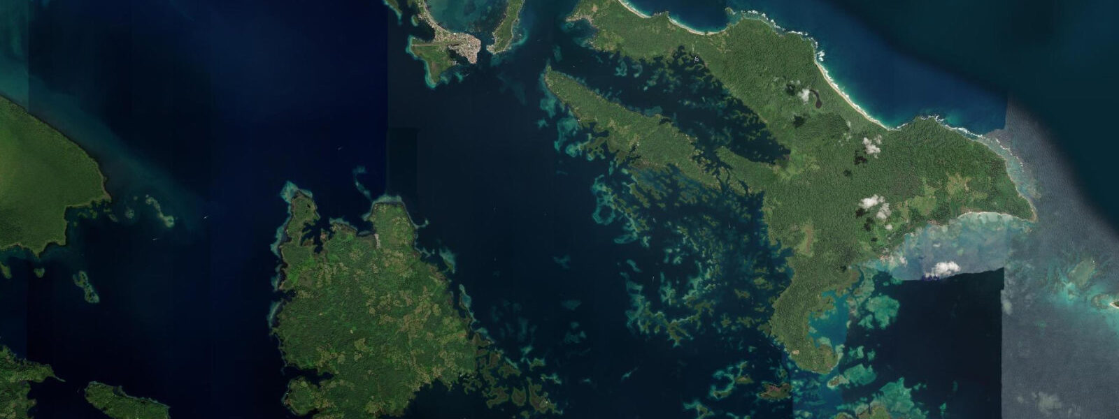
Isla Carenero is one square kilometre of Caribbean island sitting 500 m across the channel from Bocas Town on Isla Colón, in Panama's Bocas del Toro Archipelago. The crossing from Bocas Town takes five minutes by water taxi. Despite that proximity, Carenero has a different character: quieter, smaller, with a single waterfront street of restaurants and small hotels and a forest interior that covers most of the island. The channel between Carenero and Bocas Town is called the Bocas Channel, and it is one of the busier small-boat waterways in the archipelago.
The tidal regime here is Caribbean microtidal. Mean spring range at Carenero is 0.2–0.4 m — under 40 cm between a spring high and spring low. Neap tides are effectively flat: 0.1 m or less. This is the same tidal character that governs all of the Bocas del Toro Archipelago; the Caribbean simply does not produce the tidal amplitudes found on Pacific coasts. For most activities at Carenero, the tide table is a background reference rather than an operational planning tool. Current, swell, and wind do more to determine water conditions than tidal stage.
The Bocas Channel is the feature that most visitors to Carenero notice first. High-speed pangas running water-taxi routes between Bocas Town, Carenero, Bastimentos, and the mainland transit this channel constantly throughout the day. The channel is narrow enough that wake from passing pangas reaches shore within seconds. The current itself is minimal — 0.2–0.3 knots on spring tidal exchanges, which is slow enough to swim against without difficulty. But the wake is a real consideration for anyone in the water: a fully loaded panga at 25 knots generates a 0.3–0.5 m wake that arrives at Carenero's waterfront with little warning. Swimmers in the channel need to watch for vessel traffic continuously. Kayakers and paddleboarders crossing between Carenero and Bocas Town should cross perpendicular to the channel in the shortest line, check both directions before committing, and expect to be rocked by wake even when the channel appears clear.
The east side of Carenero faces the open Caribbean. There is a small beach here — a pocket of sand 40–50 m long — and a reef beginning 30 m from shore. The reef carries 1–3 m of water at high tide. With a tidal range of 0.2–0.4 m, the depth difference between high and low water over the reef is modest: at high spring the shallowest coral sits under 1 m of water, at low spring it sits under 0.6–0.8 m. For snorkellers, the east reef is best accessed at mid to high tide when there is enough water over the coral to move without touching it. At low water, the shallowest sections become genuinely tight — experienced snorkellers can still work the outer sections, but the inner reef near shore is uncomfortably close to the surface. Visibility on the east reef depends more on swell direction and recent rain (freshwater runoff from the island degrades visibility after heavy rain) than on tidal state.
The west shoreline of Carenero, facing the Bocas Channel, is mangrove. This is where the character of the island shifts most with tidal stage. At high tide, the mangrove forest presents a wall of green foliage at the waterline with the prop roots submerged and invisible. At low spring tide — roughly 0.3 m below the high — the prop roots are exposed 0.5–0.8 m above the waterline, creating a visible tangle of arching roots along the shoreline. This low-water exposure is when the mangrove edge is most interesting to observe from a kayak or slow-moving boat: the root system becomes three-dimensional, and the organisms living in the intertidal zone — small crabs, gobies, invertebrates — are briefly accessible to view.
An American crocodile (Crocodylus acutus) lives in the mangrove system on the west side of Carenero. This is not a speculation — it is a known resident, occasionally seen by locals and guides familiar with the island. The animal is most reliably observed at low water, when it sometimes basks on exposed mangrove roots in the morning sun. If you are paddling or motoring slowly along the west mangrove shoreline and spot a large, motionless grey-brown form on the roots near the waterline, stop and look before approaching. American crocodiles at this size are not typically aggressive to humans unless cornered or fed, but maintaining distance is the correct protocol. Do not paddle into the mangrove interior on the west side, particularly at low water when animals may be concentrated at the channel edge.
Restaurant Bibi's on the Carenero waterfront is the island's most established dining reference point — a wood-frame restaurant on stilts over the water, serving fresh seafood on the channel side. The waterfront tables look directly across to Bocas Town, and the panga traffic in the channel provides constant movement. Most visitors arrive at Bibi's from Bocas Town by water taxi and depart the same way; the last water taxi timing is worth confirming before you settle into a long meal, as service back to Bocas Town stops by early evening.
Tide data for Carenero Island, Bocas del Toro comes from the Open-Meteo Marine API, a gridded model product. Timing accuracy is ±45 minutes, height accuracy ±0.3 m — usable for trip planning, not for navigation.
Tide questions about Carenero Island, Bocas del Toro
Quick answers to the most common questions about tide times, range, and water access at Carenero Island, Bocas del Toro.
Is it safe to swim in the Bocas Channel between Carenero and Bocas Town?
Swimming in the Bocas Channel is not recommended. The channel carries constant water-taxi traffic — high-speed pangas making runs between Bocas Town, Carenero, Bastimentos, and the mainland throughout the day. The boats travel at 25 knots or more, the channel is narrow, and a panga crossing at that speed can be on top of a swimmer with very little warning. The current itself is not the hazard — it runs only 0.2–0.3 knots on spring tidal exchanges. The vessel traffic is the hazard. If you need to get between Carenero and Bocas Town, take the water taxi. Kayakers and paddleboarders making the crossing should go perpendicular across the channel in the shortest line, check both directions, and be prepared for panga wake even when the channel looks clear.
Can I see a crocodile at Carenero and where should I look?
An American crocodile (Crocodylus acutus) is a known resident of the mangrove system on the west shore of Isla Carenero, facing the Bocas Channel. It is most reliably seen at low water, when the mangrove prop roots are exposed 0.5–0.8 m above the waterline and the animal sometimes basks on the roots in the morning sun. The best viewing approach is from a kayak or slow-moving boat moving along the west shoreline at low tide, ideally in the first two hours after sunrise. Do not enter the mangrove interior. If you spot the crocodile, stop paddling, observe from at least 10 m distance, and do not approach the roots. With a tidal range of only 0.2–0.4 m, low-water exposure of the mangrove roots happens daily and predictably — check the Carenero tide prediction on tideturtle.com for the next low-water time.
What is the best tidal time to snorkel the east reef at Carenero?
The east reef at Carenero starts 30 m from shore and carries 1–3 m of water at high tide. With a spring tidal range of only 0.2–0.4 m, the depth difference between high and low water over the reef is modest — roughly 0.3 m. At low water, the shallowest sections of the inner reef drop to 0.6–0.8 m of water, making it very easy to accidentally contact coral. Snorkel the east reef at mid to high tide when there is at least 1 m over the shallowest sections, giving you clearance to fin without touching the coral. Visibility on the reef is more sensitive to swell and recent rainfall than to tidal stage — heavy rain causes freshwater runoff from the island that can drop visibility to 2–3 m. After a dry spell, visibility on the east reef can reach 10–15 m.
How do I get to Carenero Island and when do water taxis run?
Carenero is 500 m across the Bocas Channel from Bocas Town on Isla Colón. Water taxis depart from the Bocas Town waterfront throughout the day — the crossing takes five minutes by motorised panga and costs a few dollars. Taxis run frequently during daylight hours but service generally stops by early evening; confirm the last departure time before committing to a late meal or afternoon activity on Carenero. There is no bridge and no other way to cross. The channel current is minimal (0.2–0.3 knots spring tides) and the crossing is calm in settled weather, though the water-taxi boats generate significant wake that rocks the dock on arrival. Carenero has no roads — the waterfront street is the main infrastructure, and the rest of the island is forest accessible only by foot trail.
What is the tidal range at Carenero and does it affect water activities?
Carenero sits in the Bocas del Toro Archipelago on Panama's Caribbean coast. The tidal range here is microtidal: mean spring range 0.2–0.4 m, neap tides effectively flat at 0.1 m or less. In practical terms, tidal stage has minimal influence on most water activities at Carenero. The east reef snorkelling is slightly better at mid to high tide (see FAQ above), and the mangrove prop roots on the west shore are exposed at low water for better wildlife viewing, but neither is a strong planning constraint. Wind, swell direction, and rainfall are the variables that most affect water conditions on any given day. When planning an east reef snorkel, check the weather forecast and whether there has been recent rain — visibility is more dependent on those factors than on where the tide stands.
7-day tide table — Carenero Island, Bocas del Toro
Heights relative to MSL. Predictions: Open-Meteo Marine (MeteoFrance SMOC, 0.08° grid) — heights relative to MSL (not chart datum / LAT). Model-derived.
| Day | Type | Time | Height |
|---|---|---|---|
| Fri 19 Jun | Low | 10:54 | -0.1m |
| Sat 20 Jun | High | 04:15 | 0.4m |
| Low | 11:18 | -0.0m | |
| High | 18:00 | 0.3m | |
| Low | 23:50 | 0.1m | |
| Sun 21 Jun | High | 05:00 | 0.3m |
| Low | 11:50 | 0.0m | |
| Mon 22 Jun | High | 05:50 | 0.2m |
| Low | 12:10 | 0.0m | |
| High | 19:10 | 0.4m | |
| Tue 23 Jun | Low | 13:00 | 0.0m |
| High | 20:00 | 0.4m | |
| Wed 24 Jun | Low | 03:50 | 0.0m |
| High | 09:00 | 0.1m | |
| Low | 13:00 | 0.1m | |
| High | 20:45 | 0.4m | |
| Thu 25 Jun | Low | 05:00 | -0.0m |
| High | 18:00 | 0.3m |