Bocas del Toro, Panama tide times
Bocas del Toro, Panama tide forecast — heights relative to MSL.
Today's tide times for Bocas del Toro, Panama
Tide times at Bocas del Toro, Panama on Sunday, 5 July 2026: first high tide at 04:00am. Sunrise 06:14am, sunset 06:53pm.
Tide chart for Bocas del Toro, Panama
24-hour cosine-interpolated curve around the present moment. Heights relative to MSL. Predictions: Predictions: Open-Meteo Marine (MeteoFrance SMOC, 0.08° grid).
Sun, moon and conditions on Sun 05 Jul
Snapshot at build time — refreshes daily. Sea state from Open-Meteo Marine.
Highs and lows next 7 days
Every predicted high and low for the next week, with the daily tidal coefficient (0–120; higher = bigger swing, > 95 means stronger currents).
Other spots nearby
The three closest curated TideTurtle locations to Bocas del Toro, Panama, measured by great-circle distance.
Today's solunar windows
Solunar tradition: major periods are the ≈3h windows around moon transit and opposition; minor are ≈2h around moonrise and moonset. Pair with the local tide stage and wind for the best read.
About tides at Bocas del Toro, Panama
A short guide to the coastline at Bocas del Toro, Panama — geography, sea state, and what the tide is actually doing under your feet.
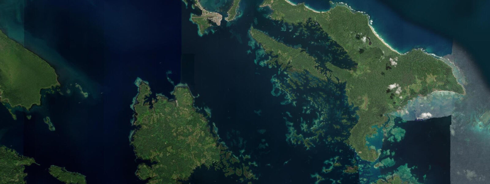
Bocas del Toro town occupies the southern tip of Isla Colón, the largest island in the archipelago, and functions as the hub for everything that happens in this corner of Caribbean Panama. The streets are narrow, the buildings are mostly wood-frame Caribbean architecture painted in salt-faded yellows and greens, and the main commercial street runs one block from the water along a dock front where water taxis, dive boats, and fishing pangas compete for space. The Bocas Marina, such as it is, handles private sailboats arriving from the Caribbean crossing. The airport — a short strip on the island's middle section — takes 20-seat Cessna Caravans from Panama City and San José.
Almirante Bay, the large shallow bay that makes up the inner archipelago, opens south and east from the town dock. Dolphin-watching tours run into the bay in the mornings when Indo-Pacific bottlenose dolphins work the shallow seagrass beds; the flat, calm inner bay water is also the primary SUP and kayak zone, protected from Caribbean swell by the ring of islands. The outer coast of Isla Colón — the north and west facing shores — receives the Caribbean swells that push in from the northeast trade wind window.
The tidal regime in Bocas del Toro is Caribbean microtidal: spring range 20 to 40 centimetres. The astronomical tide is the quietest component of water level variation in the harbour. Caribbean weather systems — tropical waves, depressions, and winter cold fronts that push from North America between December and February — produce surge and swell events that raise the harbour level by more than the full spring tidal range in a matter of hours. The town dock and the low-lying streets at the southern end of the island are vulnerable to these events; the October–December and March–April transitional weather periods are the most active surge seasons.
Under normal conditions the small tidal range means the water taxis, kayaks, and dive boats operate on departure time schedules independent of the tide. The coral reefs in the bay — at Cayo Crawl on Isla Bastimentos, at Hospital Point on the west side of Isla Colón — are at a consistent depth relative to the surface year-round; the 20 to 40 centimetre tidal movement does not meaningfully change the entry or diving depth. Visibility in the bay is depth and turbidity dependent rather than tide dependent.
The town's character has shifted over the past two decades from a banana industry outpost (the United Fruit Company operated in the region from the early twentieth century, and the port at Almirante on the mainland still loads fruit vessels) to a backpacker hub and, more recently, a mid-range tourism destination with a growing expat residential community. The two modes coexist on the main street: juice bars and surf shops next to hardware stores and the Chinese-owned provisioning supermarkets that supply both the local fishing fleet and the sailboats.
Reef diving is the primary activity beyond the town itself. Hospital Point, on the western outer coast of Isla Colón, has a coral wall dropping from the surface to 20-plus metres with gorgonian fans, sea turtles, and the nurse sharks that rest in the sandy channels between coral heads. The Cayos Zapatillas — a pair of uninhabited cays 15 kilometres south of town — are a full-day boat trip with the best coral coverage in the archipelago.
The bat cave (Cueva del Vampiro) on the western shore of the island is accessible by kayak at any water level given the minimal tidal variation; the cave houses a colony of fishing bats (Noctilio leporinus) that emerge at dusk. The red poison-dart frogs (Oophaga pumilio) common throughout the Bocas archipelago live in the forest above the cave and along most forested trails on the island.
Tide predictions for Bocas del Toro town come from Open-Meteo Marine, a global gridded ocean model. Accuracy is within plus or minus 45 minutes on timing and 0.2 to 0.3 metres on height. On a 20 to 40 centimetre spring coast, the primary water level planning input is the regional weather and Caribbean swell forecast, not the tide table.
Tide questions about Bocas del Toro, Panama
Quick answers to the most common questions about tide times, range, and water access at Bocas del Toro, Panama.
What is the tide range in Bocas del Toro and does it affect diving or kayaking?
The spring tidal range in Bocas del Toro is 20 to 40 centimetres — microtidal, one of the smallest astronomical tidal signals in the Americas. For most practical activities this range is irrelevant: kayaks, water taxis, and dive boats operate on time schedules with no tide dependency, and coral reefs maintain a consistent depth relative to the surface across the tidal cycle. The larger water level variable on this coast is weather-driven: Caribbean cold fronts in winter and tropical weather systems in the transition seasons can raise harbour level by more than the full spring range in a few hours. These events are tracked by weather forecast rather than tide table. Tide predictions come from Open-Meteo Marine, accurate within plus or minus 45 minutes and 0.2 to 0.3 metres.
How do I get from Bocas del Toro town to the outer reefs for diving?
The main reef sites are reached by boat from the town dock. Hospital Point on the west outer coast of Isla Colón is approximately 20 minutes by fast panga; Cayo Crawl on the inner side of Isla Bastimentos is 25 minutes; the Cayos Zapatillas are 45 to 60 minutes south. Dive operators based on the main street run twice-daily departures (typically 08:00 and 13:00) with equipment hire included. The inner bay reefs accessible by kayak from town — the coral patches around Isla Carenero and the closer Bastimentos shore — have lower visibility than the outer sites but are easily accessed without a motorboat. Water conditions for both are not tide-dependent given the microtidal range.
Where can I see dolphins in Bocas del Toro?
Indo-Pacific bottlenose dolphins regularly work the shallow seagrass beds of the inner Almirante Bay, particularly in the mornings from dawn to around 10:00 before the wind picks up. Water-taxi operators and dedicated dolphin tour boats run morning trips from the town dock into the bay; the flat, calm inner water provides good visibility of the animals. Dolphin Bay, a shallow embayment on the east side of Isla Colón approximately 15 minutes by water taxi from town, is the most consistent location. Spinner dolphins are occasionally seen in the outer bay near the channel entrances. Sightings are not guaranteed — the animals move with the fish and are not managed or fed.
What is the weather and water temperature like in Bocas del Toro?
Sea surface temperature in the Bocas del Toro archipelago stays between 27 and 30°C year-round with minimal seasonal variation. Air temperature is consistently 27 to 32°C. Rainfall is high — the Caribbean slope of Panama is one of the wettest coastlines in the Americas, receiving over 3,000 millimetres annually — and there is no true dry season comparable to the Pacific coast. February and March are statistically the driest months; October is typically the wettest. The main weather risk is the Caribbean cold front season from December through February, when North American cold air masses push south, producing northerly swells and occasionally raising harbour water levels. Strong hurricane-track weather is rare this far south in the Caribbean but not impossible.
Are the red poison-dart frogs easy to find near Bocas del Toro town?
The Bocas del Toro endemic variety of the red poison-dart frog (Oophaga pumilio) is common in the forest on Isla Colón and the other islands of the archipelago. The population on Isla Colón has evolved a vivid red-orange colouration more saturated than mainland populations. They are most visible on the forest floor of secondary and primary forest, particularly near Playa Bluff and along the road that crosses the island to Bocas del Drago on the north coast. Early morning is the most active period. The frogs are not aggressive and sit still when approached; the toxicity is diet-derived and is not a risk to observers who do not handle them. The bat cave trail on the western shore of the island is also a reliable location.
7-day tide table — Bocas del Toro, Panama
Heights relative to MSL. Predictions: Open-Meteo Marine (MeteoFrance SMOC, 0.08° grid) — heights relative to MSL (not chart datum / LAT). Model-derived.
| Day | Type | Time | Height |
|---|---|---|---|
| Sun 05 Jul | High | 04:00 | 0.3m |
| Mon 06 Jul | Low | 10:50 | 0.1m |
| High | 18:00 | 0.4m | |
| Tue 07 Jul | Low | 11:00 | 0.1m |
| Wed 08 Jul | High | 19:00 | 0.4m |
| Thu 09 Jul | — | ||
| Fri 10 Jul | — | ||
| Sat 11 Jul | Low | 04:50 | -0.0m |
| High | 18:00 | 0.3m | |