Port Waikato, Waikato tide times
Port Waikato, Waikato tide forecast — heights relative to MSL.
Tide chart for Port Waikato, Waikato
24-hour cosine-interpolated curve around the present moment. Heights relative to MSL. Predictions: Predictions: Open-Meteo Marine (MeteoFrance SMOC, 0.08° grid).
Sun, moon and conditions on Sun 21 Jun
Snapshot at build time — refreshes daily. Sea state from Open-Meteo Marine.
Highs and lows next 7 days
Every predicted high and low for the next week, with the daily tidal coefficient (0–120; higher = bigger swing, > 95 means stronger currents).
Other spots nearby
The three closest curated TideTurtle locations to Port Waikato, Waikato, measured by great-circle distance.
Today's solunar windows
Solunar tradition: major periods are the ≈3h windows around moon transit and opposition; minor are ≈2h around moonrise and moonset. Pair with the local tide stage and wind for the best read.
Cycle dates near Port Waikato, Waikato
Last spring tide on Fri 19 Jun (range 2.6m). Next neap on Thu 25 Jun.
Spring tides cluster around new and full moons (biggest swings). Neap tides land on quarter moons (smallest swings). See the spring tide and neap tide glossary entries for the why.
About tides at Port Waikato, Waikato
A short guide to the coastline at Port Waikato, Waikato — geography, sea state, and what the tide is actually doing under your feet.
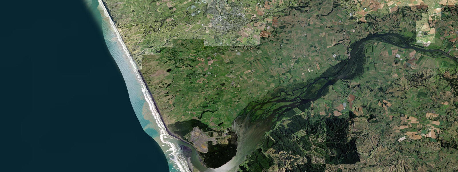
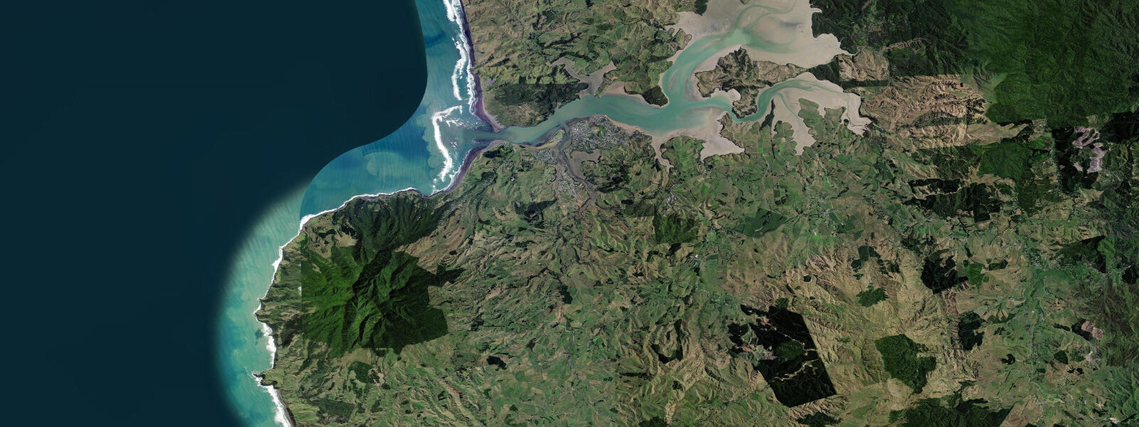
Port Waikato is a small beach settlement where New Zealand's longest river meets the Tasman Sea, 80 km south of Auckland on the west coast of the Waikato Region. The Waikato River drains 14,820 square kilometres of the North Island's interior, including the volcanic plateau around Lake Taupo, and exits through a bar that is one of the more consequential harbour entrances in New Zealand for small vessels. The beach north and south of the mouth is ironsand — magnetite-rich volcanic sand, dark grey when dry, black when the tide has just ebbed across it.
The tidal regime here is Pacific west coast mixed semidiurnal: two highs and two lows per day, with diurnal inequality that produces noticeably unequal heights between the two daily highs. Spring range runs 2.5–3.5 m — a large range for the west coast, driven by the Tasman Sea's long fetch. At low spring water the beach reveals its full width, sometimes 80–100 m of dark ironsand, and the river mouth bar dries partially on the outer edge. At high spring water the bar carries enough depth that larger vessels can cross, but the current through the channel is still significant.
The Waikato River bar is the defining physical feature of Port Waikato, and its reputation among small-boat operators is earned. The river delivers a continuous sediment load from the volcanic plateau — silts and sands that have been depositing at this mouth for millennia — and that load meets the Tasman Sea swell head-on. The bar builds across the channel, the swell breaks across its face, and the tidal current runs 2–4 knots through the navigable channel regardless of the wave conditions. On a low tide with a 2.0 m Tasman Sea swell, the bar breaks continuously and no small vessel crosses safely. On a mid-to-high tide with a 1.0 m swell, an experienced local skipper can read the sets and cross between them. The channel position shifts seasonally — the bar's shape in winter, when swell is larger and more consistent from the southwest, is different from its summer configuration.
Local fishing boats time their crossings to mid-to-high water and to the local knowledge of the current channel line. The standard approach is to watch a set of waves from the beach or the breakwater, identify the shallowest zone, locate the deeper water to one side of the main break, and choose the crossing window between sets. This is not a procedure for visitors without local familiarity. Port Waikato has seen incidents at the bar; the river rescue services know this crossing.
Tuatua Point headland sits on the northern side of the river mouth, where the beach curves around to face more directly southwest. The headland provides some shelter for vessels holding off the bar while waiting for a set to clear, and the rocks at its base are a shore-fishing platform for the kahawai that work the current line on the ebb.
Kahawai (Arripis trutta) are the dominant target for shore anglers at Port Waikato. They are pelagic, schooling, and aggressive — a 1.5 kg kahawai on light gear is a different fish from the same species caught on heavy surf tackle. The most productive approach from the beach is to cast into the gutters that form at the river mouth on the ebb tide, where the current differential between the river outflow and the sea surface creates a rip that baitfish use as a corridor. A metal lure or soft bait cast across the current line on the ebb, with a slow retrieve, produces kahawai consistently through the autumn and winter months when the schools move inshore.
Snapper are present in the nearshore waters, particularly along the ironsand beach south of the river mouth where the bottom drops away into deeper water. Surf-fishing for snapper is a waiting game — bait on the bottom, cast to where the beach shelves, on an incoming tide when the fish are moving toward the beach.
Whitebait season at Port Waikato runs August to September and targets juvenile galaxiid fish (predominantly Galaxias maculatus, the common smelt) on their upstream migration from the sea into the river. Whitebaiters position nets in the river mouth on the ebb tide — the juveniles aggregate in the slack water behind the current and move on the ebb when they are hardest to distinguish from the drift. A whitebait stand at the river mouth, positioned on the sheltered inside bend, works the ebb current by creating a net mouth that faces into the flow. The best whitebait conditions are a moderate ebb on a calm, overcast day — bright sunlight and heavy current both suppress feeding and migration behaviour.
The ironsand beach itself is worth noting. The dark sand is magnetite (Fe₃O₄), a volcanic mineral carried from the central plateau by the Waikato River and deposited here over thousands of years. After a large river flood the fresh ironsand deposit is conspicuous — a dark layer on top of the existing beach, sometimes 10–20 cm deep. A magnet dragged through the sand picks up the magnetite grains directly. The colour contrast between the black ironsand and white seafoam at the water's edge is distinctive on overcast days and has made Port Waikato beach a frequent subject for photographers who work with the high-contrast light that the west coast delivers.
Raglan, 50 km north, is the better-known west coast surf destination; Port Waikato has a fraction of that traffic and none of the crowd.
Tide data for Port Waikato, Waikato comes from the Open-Meteo Marine API, a gridded model product. Timing accuracy is ±45 minutes, height accuracy ±0.3 m — usable for trip planning, not for navigation.
Tide questions about Port Waikato, Waikato
Quick answers to the most common questions about tide times, range, and water access at Port Waikato, Waikato.
What tidal conditions are needed to cross the Waikato River bar safely at Port Waikato?
Local fishing boats cross the Waikato River bar on mid-to-high water — typically from two hours before high tide to one hour after. At low tide the bar can dry partially on its outer face and the swell breaks continuously across the channel in any sea state above 1.0 m. The current through the channel runs 2–4 knots at all tidal stages, which means even at high water a vessel must maintain directional control in flowing water while reading incoming sets. The channel position shifts seasonally and is not marked with transits. Visitors without local knowledge should not attempt the bar crossing without following an experienced local vessel. The bar has been the site of multiple small-vessel incidents; Port Waikato's reputation among west coast boaters is based on these events.
When does whitebait season run at Port Waikato and how do anglers time it to the tide?
The whitebait season runs August to September, targeting juvenile galaxiid fish (primarily Galaxias maculatus) on their upstream migration from the sea into the Waikato River. Whitebaiters position hand nets or stand nets in the river mouth on the ebb tide — the juveniles migrate on the ebb when they travel downstream in the current margin, and are easiest to intercept in the slack water behind current lines near the inner bank. The best conditions are a moderate ebb, overcast skies, and calm wind: bright sunlight suppresses migration activity, and a strong current pushes the fish too fast through the net mouth. The ebb window in the morning — the first ebb after the first high tide of the day — tends to produce the best catches at this site.
What is the ironsand at Port Waikato and what causes its distinctive black colour?
The ironsand at Port Waikato is magnetite (iron oxide, Fe₃O₄), a volcanic mineral derived from the andesitic and rhyolitic rocks of the central North Island volcanic plateau. The Waikato River transports this material from the volcanic uplands — where it weathers from pyroclastic deposits and lava flows — and deposits it at the river mouth. The beach accumulates the heavier magnetite fraction while finer silts are carried offshore. After a significant river flood, a fresh dark deposit is visible on the upper beach face. The sand is visibly magnetic — a magnet drawn through the damp surface layer picks up grains. When the tide ebbs across the black sand and the water retreats, the colour is at its most intense because the saturated magnetite absorbs light efficiently.
When is the best time to fish for kahawai from the beach at Port Waikato?
Kahawai are most consistently available from the Port Waikato beach and river mouth during the ebb tide, particularly in the gutters and rip channels that form as the river outflow meets the receding sea. The ebb creates current differentials between the river outflow and the open sea surface that baitfish use as corridors — and kahawai school at the edges of those corridors to intercept them. A metal lure or soft bait cast across the current line and retrieved slowly through the gutter produces fish. The autumn and winter months (March–August) bring kahawai schools closest inshore on the west coast as water temperatures drop and the fish follow baitfish movements. The Tuatua Point headland on the north side of the river mouth is a productive platform for shore casting into the current line on the ebb.
What is the tidal range at Port Waikato and how much beach is exposed at low tide?
Spring tides at Port Waikato produce a range of 2.5–3.5 m. At low spring water the beach width is at its maximum — the ironsand flat can extend 80–100 m from the high-water mark to the water's edge, and the river mouth bar partially dries on the outer edge. At high spring water the bar carries sufficient depth for larger fishing vessels but the current through the channel remains strong. The diurnal inequality on the west coast means the two daily low tides are not equal — the lower low can be 0.4–0.6 m below the higher low, which noticeably changes the beach width and the bar depth. For anyone planning a beach walk or photography session timed to low water, checking which of the day's two lows is the lower one is worth doing.
7-day tide table — Port Waikato, Waikato
Heights relative to MSL. Predictions: Open-Meteo Marine (MeteoFrance SMOC, 0.08° grid) — heights relative to MSL (not chart datum / LAT). Model-derived.
| Day | Type | Time | Height |
|---|---|---|---|
| Sun 21 Jun | High | 00:42 | 1.5m |
| Low | 07:03 | -1.1m | |
| High | 13:12 | 1.3m | |
| Low | 19:18 | -1.0m | |
| Mon 22 Jun | High | 01:36 | 1.5m |
| Low | 07:56 | -0.9m | |
| High | 14:04 | 1.2m | |
| Tue 23 Jun | Low | 08:52 | -0.8m |
| High | 15:00 | 1.1m | |
| Low | 21:12 | -0.6m | |
| Wed 24 Jun | High | 03:22 | 1.2m |
| Low | 09:46 | -0.7m | |
| High | 16:00 | 1.1m | |
| Low | 22:10 | -0.5m | |
| Thu 25 Jun | High | 04:18 | 1.2m |
| Low | 10:40 | -0.5m | |
| High | 17:03 | 1.2m | |
| Low | 23:10 | -0.3m | |
| Fri 26 Jun | High | 05:18 | 1.3m |
| Low | 11:37 | -0.4m | |
| High | 17:57 | 1.3m | |
| Sat 27 Jun | Low | 00:10 | -0.3m |
| High | 06:09 | 1.2m | |
| Low | 11:00 | -0.3m |