
Swakopmund tide times
Swakopmund tide forecast — heights relative to MSL.
Today's tide times for Swakopmund
Tide times at Swakopmund on Saturday, 4 July 2026: first low tide at 02:00am, first high tide at 05:26am, second low tide at 11:14am, second high tide at 05:43pm, third low tide at 11:57pm. Sunrise 07:42am, sunset 06:29pm.
Tide chart for Swakopmund
24-hour cosine-interpolated curve around the present moment. Heights relative to MSL. Predictions: Predictions: Open-Meteo Marine (MeteoFrance SMOC, 0.08° grid).
Sun, moon and conditions on Sat 04 Jul
Snapshot at build time — refreshes daily. Sea state from Open-Meteo Marine.
Highs and lows next 7 days
Every predicted high and low for the next week, with the daily tidal coefficient (0–120; higher = bigger swing, > 95 means stronger currents).
Other spots nearby
The three closest curated TideTurtle locations to Swakopmund, measured by great-circle distance.
Today's solunar windows
Solunar tradition: major periods are the ≈3h windows around moon transit and opposition; minor are ≈2h around moonrise and moonset. Pair with the local tide stage and wind for the best read.
Cycle dates near Swakopmund
Last spring tide on Sat 04 Jul (range 1.1m). Next spring tide on Fri 10 Jul (range 0.9m). Next neap on Wed 08 Jul.
Spring tides cluster around new and full moons (biggest swings). Neap tides land on quarter moons (smallest swings). See the spring tide and neap tide glossary entries for the why.
About tides at Swakopmund
A short guide to the coastline at Swakopmund — geography, sea state, and what the tide is actually doing under your feet.
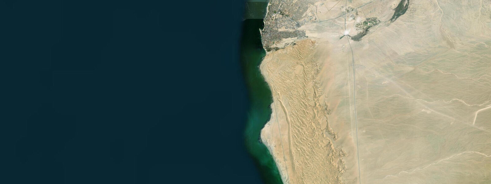
Swakopmund sits at one of the world's sharpest coastal contrasts: the Namib Desert — one of the oldest on earth, roughly 55 million years old — runs directly to the South Atlantic shoreline with no transition. Stand on the beach at low tide and you have desert gravel behind you and ocean in front, with nothing softening the boundary.
The Benguela Current is responsible for everything unusual about this coast. Cold Antarctic water upwells northward and suppresses sea surface temperatures to 12-15°C year-round, cold enough that swimming is an act of genuine commitment rather than casual relief. The cold water beneath warm oceanic air creates the suther suther, the persistent advection fog that rolls in most mornings before noon and sustains the Namib's fog-dependent ecosystem of beetles, lichens, and succulents. For photographers, the fog mornings are the most interesting hours — the light is flat and soft, the dunes behind town disappear into grey, and the lighthouse emerges from the murk at intervals.
The Swakopmund lighthouse was built in 1902 and still operates as an active navigational aid. At 28 metres it is modest, but the position — set back from the beach just south of the jetty — gives it good visibility from the sea approaches. The jetty itself, rebuilt in reinforced concrete, extends 194 metres into the South Atlantic and is the standard evening walk for both residents and visitors. Anglers work the end section from the jetty railing; galjoen, steenbras, and kabeljou (kob) are the main target species. The incoming tide is the productive window — the last two hours of the flood and the first hour of the ebb concentrates bait fish against the structure.
The tidal regime at Swakopmund is mixed semidiurnal. Spring tidal range runs approximately 1.5 to 2.0 metres. The two daily high tides are frequently unequal, with the difference most pronounced around the solstices. At low water on a spring tide, the beach widens substantially and the kelp forest at the low-tide line is accessible — brown kelp (Ecklonia maxima) forms dense stands on the rocky reef north of the jetty, and the root holdfasts and fronds are exposed for 40 to 60 minutes either side of low water. The kelp line is worth walking: the combination of cold water, fog, and the kelp smell is specifically Namibian, unlike any other African coastal experience.
The town was established in 1892 as the main port of German South West Africa. The colonial building period, roughly 1900 to 1915, produced a Wilhelmine townscape that survives in remarkable condition — the dry desert air prevents the humidity-driven deterioration that has destroyed comparable buildings in other coastal colonies. The Bahnhof (railway station, 1901, now the Swakopmund Hotel) anchors the southern end of the historic centre; the Kaserne (military barracks, 1905) and Woermannhaus (1905, with its distinctive water tower) are within a five-minute walk. The architecture is not theatrical — it is competent colonial-era northern European design applied to a desert port — but the preservation quality is genuinely unusual.
Sandboarding on the Namib dunes east of town is the most reliably popular activity. The dune face directly accessible from the town's eastern edge drops 80 to 100 metres and the sand is consistently dry enough for good run speeds. Licensed operators provide boards and the shuttle to the top; the sport is a mix of lying-down descent for speed runs and standing board technique for the more practiced. No tidal relevance, obviously, but it is worth knowing that the morning fog often makes the early dune runs cooler and more visually interesting than the clear-sky afternoon sessions.
Namibian seafood is a specific pleasure. Rock lobster (locally called crayfish, Jasus lalandii) is caught in the cold Benguela waters and is a reliable staple at the waterfront restaurants. Walvis Bay oysters, farmed in the lagoon 30 kilometres south, appear fresh on most menus. The cold, nutrient-rich water produces fat, firm-bodied oysters with a clean mineral flavour. Mussels farmed in the same lagoon waters are comparably good. If the menu includes leervis (garrick) caught from the surf, it is worth ordering.
The Swakopmund Museum, housed in the old warehouse building near the harbour, covers the town's colonial history, the Benguela ecosystem, and the desert-adapted biology of the Namib. The natural history section is the most informative — the fog beetle display alone is worth twenty minutes. The museum also holds the most coherent account of the Herero and Nama genocide (1904-1908), the German colonial campaign that killed an estimated 80,000 people in the interior. This history sits behind the preserved architecture and the pleasant waterfront; the museum presents it without evasion.
Predictions on this page come from Open-Meteo Marine, a gridded global ocean model. Accuracy is typically within plus or minus 45 minutes on timing and 0.2 to 0.3 metres on height — model-derived, not from a local gauge. The authoritative national sources for tidal and maritime data on the Namibian coast are the Namibian Meteorological Service and the Namibia Ports Authority.
Tide questions about Swakopmund
Quick answers to the most common questions about tide times, range, and water access at Swakopmund.
What is the tidal range at Swakopmund and when is low tide best for the kelp reef?
Swakopmund has a mixed semidiurnal tidal pattern — two highs and two lows per day, often unequal in height. Spring tidal range is approximately 1.5 to 2.0 metres. At low water on a spring tide, the beach widens considerably and the kelp forest on the rocky reef north of the jetty is exposed. The kelp is most accessible in the 40 to 60 minutes either side of the lowest point of a spring low — check the tide table and plan to be at the reef edge 30 minutes before low water. Neap tides produce a smaller range and may not expose the kelp bed meaningfully. The Namibian Meteorological Service publishes annual tidal predictions; the Open-Meteo Marine model on this page gives a reliable indication of timing for planning purposes.
Is the sea warm enough to swim at Swakopmund?
No, not by any conventional standard. The Benguela Current keeps sea surface temperatures at 12-15°C year-round — cold enough to produce discomfort after a few minutes of immersion for most people. The water is far colder than the air temperature suggests, and the fog mornings add wind chill. Some local surfers and cold-water swimmers do enter the water regularly, and wetsuits are standard. Expect 3/2mm as a minimum; a 4/3mm suit is more comfortable for sessions longer than 30 minutes. This is not Mediterranean swimming; it is Benguela swimming, which is a fundamentally different proposition.
What fish can I catch from Swakopmund pier and beach?
The jetty and surf beaches around Swakopmund produce galjoen, steenbras, kabeljou (kob), and white stumpnose. Galjoen is Namibia's most sought-after shore species and is more consistently caught from the rocky areas north of the jetty during the incoming tide. Kabeljou (kob) are the main jetty fish, feeding in the last two hours of the flood and first hour of the ebb. Sand shark (smoothhound) are frequently encountered from the beach at night. The Namibian shore-fishing regulations require a valid fishing permit — obtain one from the Ministry of Fisheries and Marine Resources before fishing. Bait rules and bag limits apply; galjoen has a minimum size of 25cm and a daily bag limit.
What is the best time of year to visit Swakopmund?
Most months are comfortable, but the choice depends on what you are after. June through August brings the coldest sea and air temperatures (8-16°C air, 12-13°C water), frequent fog, and the most dramatic desert-meets-ocean light conditions — preferred by photographers and birdwatchers. January through March is warmer (20-25°C, occasionally more) with less fog and longer clear-sky windows — better for sandboarding and outdoor comfort. The town is busiest in December and January when South African holidaymakers arrive in numbers. Avoid the August long weekend if you want quiet. There is no rainy season on the coast — rainfall at Swakopmund averages under 20mm per year — so weather-based cancellations are almost unknown.
Can I visit Walvis Bay Lagoon and see the flamingos from Swakopmund?
Walvis Bay Lagoon is 30 kilometres south — a 25-minute drive on the B2 highway. The RAMSAR-listed lagoon supports 60,000 or more greater flamingo on its tidal mudflats, along with pelicans, cormorants, and the globally significant chestnut-banded plover population. The best viewing is from the Walvis Bay waterfront drive, where the flamingo often feed within 50 to 200 metres of the road at low water. Kayaking tours depart from the lagoon edge and paddle among the flamingo and pelican colonies — operators include tours from Swakopmund with transport included. Low tide on a spring cycle exposes the most mudflat and concentrates the birds in the shallower sections closest to the shore road.
8-day tide table — Swakopmund
Heights relative to MSL. Predictions: Open-Meteo Marine (MeteoFrance SMOC, 0.08° grid) — heights relative to MSL (not chart datum / LAT). Model-derived.
| Day | Type | Time | Height |
|---|---|---|---|
| Sat 04 Jul | Low | 02:00 | -0.5m |
| High | 05:26 | 0.1m | |
| Low | 11:14 | -0.8m | |
| High | 17:43 | 0.3m | |
| Low | 23:57 | -0.8m | |
| Sun 05 Jul | High | 06:11 | 0.1m |
| Low | 11:55 | -0.7m | |
| High | 18:16 | 0.3m | |
| Mon 06 Jul | Low | 00:40 | -0.8m |
| High | 06:55 | 0.1m | |
| Low | 12:45 | -0.6m | |
| High | 19:00 | 0.2m | |
| Tue 07 Jul | Low | 01:25 | -0.8m |
| High | 07:48 | 0.1m | |
| Low | 13:42 | -0.6m | |
| High | 19:55 | 0.1m | |
| Wed 08 Jul | Low | 14:52 | -0.6m |
| High | 20:57 | 0.1m | |
| Thu 09 Jul | Low | 03:37 | -0.8m |
| High | 10:10 | 0.1m | |
| Low | 16:10 | -0.6m | |
| High | 22:12 | 0.1m | |
| Fri 10 Jul | Low | 04:48 | -0.8m |
| High | 11:23 | 0.1m | |
| Sat 11 Jul | Low | 01:00 | 0.0m |