Lampi Island tide times
Lampi Island tide forecast — heights relative to MSL.
Today's tide times for Lampi Island
Tide times at Lampi Island on Saturday, 4 July 2026: first low tide at 06:30am, first high tide at 11:58am, second low tide at 06:10pm. Sunrise 05:39am, sunset 06:23pm.
Tide chart for Lampi Island
24-hour cosine-interpolated curve around the present moment. Heights relative to MSL. Predictions: Predictions: Open-Meteo Marine (MeteoFrance SMOC, 0.08° grid).
Sun, moon and conditions on Sat 04 Jul
Snapshot at build time — refreshes daily. Sea state from Open-Meteo Marine.
Highs and lows next 7 days
Every predicted high and low for the next week, with the daily tidal coefficient (0–120; higher = bigger swing, > 95 means stronger currents).
Other spots nearby
The three closest curated TideTurtle locations to Lampi Island, measured by great-circle distance.
Today's solunar windows
Solunar tradition: major periods are the ≈3h windows around moon transit and opposition; minor are ≈2h around moonrise and moonset. Pair with the local tide stage and wind for the best read.
Cycle dates near Lampi Island
Last spring tide on Sat 04 Jul (range 2.5m). Next neap on Wed 08 Jul.
Spring tides cluster around new and full moons (biggest swings). Neap tides land on quarter moons (smallest swings). See the spring tide and neap tide glossary entries for the why.
About tides at Lampi Island
A short guide to the coastline at Lampi Island — geography, sea state, and what the tide is actually doing under your feet.
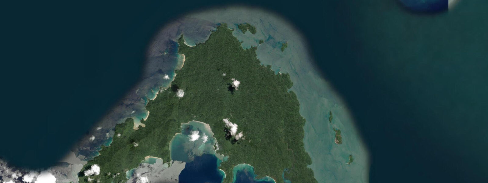
Lampi Island — Ko Lam Pi in Thai, Lampi Kyun in Burmese — is the largest island in the Lampi Marine National Park, covering approximately 205 square kilometres in the northern section of the Mergui Archipelago, Myanmar. The island rises to forested hills above 300 metres and its coastline is a succession of white sand beaches, granite headlands, and fringing coral reef. The marine park designation, gazetted in 1996, provides legal protection to the surrounding reef and waters, though enforcement capacity in this remote area is limited.
The tidal regime at Lampi is mixed semidiurnal with a spring range of approximately 3 to 4 metres — substantial for a mid-archipelago island location. The lower range compared to Kawthaung and Myeik reflects Lampi's more open ocean exposure relative to the enclosed estuaries of the coast. At low water springs, the reef flats on the sheltered eastern bays of Lampi expose 100 to 200 metres of inter-tidal platform — sand, rubble, and living reef. These flats are the primary foraging ground for dugong (Dugong dugon) in the Mergui Archipelago; seagrass meadows in the sheltered bays of Lampi and the surrounding islands are among the most intact remaining in the Andaman Sea.
Access to Lampi is by liveaboard from Kawthaung, the closest departure point — Lampi sits approximately 60 kilometres north of Kawthaung by sea, a 4 to 5 hour journey by liveaboard at cruising speed. Day trip access from Kawthaung is theoretically possible but the sea transit is long for a day return. Liveaboard itineraries typically spend 2 to 3 days around Lampi as part of a longer Mergui circuit.
The coral reef around Lampi is in the better condition of the northern Mergui islands because of the reduced fishing pressure from the marine park designation. Sea turtle nesting — primarily green turtle (Chelonia mydas) and hawksbill (Eretmochelys imbricata) — occurs on the undisturbed beach sections. Nesting season in the Andaman region runs March to September, with hatching from June to November. Liveaboard guests should observe any turtle activity from a respectful distance and avoid beaches with nesting signs in the night hours.
The inter-tidal reef flat at low water springs on the eastern side of Lampi exposes a rich community: sea cucumbers (multiple species, harvested by Moken for dried sea cucumber trade), giant clam (Tridacna squamosa), fiddler crabs, and the tracks and shells of mollusk species. The Moken community historically worked these flats as part of their seasonal harvest cycle; relations between liveaboard operators and Moken in the area are an ongoing aspect of the archipelago's management context.
Bird life on Lampi includes the Nicobar pigeon (Caloenas nicobarica) — a large, iridescent ground pigeon found on forested island chains from the Andaman Sea to the Pacific — and the critically endangered Narcondam hornbill's range boundary. White-bellied sea eagle nests on the Lampi headlands; brahminy kite is common along the shore.
Predictions on this page come from Open-Meteo Marine, a gridded global ocean model. Accuracy is typically within plus or minus 45 minutes on timing and 0.2 to 0.3 metres on height — model-derived, not from a local gauge. The local tide authority is the Myanmar Department of Meteorology and Hydrology (DMH).
Tide questions about Lampi Island
Quick answers to the most common questions about tide times, range, and water access at Lampi Island.
Are there dugong at Lampi Island?
Dugong (Dugong dugon) have been recorded in the seagrass meadows of the sheltered eastern bays around Lampi Island and the surrounding Mergui Archipelago islands. The seagrass beds in these protected bays are among the most intact in the Andaman Sea and provide the feeding habitat dugong require. Sightings are not guaranteed — dugong are elusive and the population in the Mergui Archipelago is not well-surveyed. Liveaboard guides who regularly work the area have the best current intelligence on sighting frequency. If encountered, maintain a distance of at least 20 metres and do not enter the water or approach by boat in a way that causes the animal to change course.
What is the tidal range at Lampi Island?
Spring tidal range at Lampi Island is approximately 3 to 4 metres — substantial, but slightly less than the 4 to 5 metres at Kawthaung due to Lampi's more open-ocean exposure relative to the enclosed estuary. At low water springs, reef flats on the sheltered eastern bays expose 100 to 200 metres of inter-tidal platform. Predictions here come from Open-Meteo Marine (±45 minutes on timing, ±0.3 m on height). Not for navigation; consult the Myanmar Department of Meteorology and Hydrology (DMH) for the Tanintharyi coast.
Can I see sea turtles nesting at Lampi?
Green turtle (Chelonia mydas) and hawksbill turtle (Eretmochelys imbricata) nest on the undisturbed beach sections of Lampi Island. Nesting season in the Andaman region runs March to September; hatching occurs June to November. Liveaboard guests who anchor off Lampi during nesting season may observe turtle tracks on the beach at dawn (the only indication of overnight nesting activity). Do not approach, touch, or illuminate nesting turtles or hatchlings. Beach lighting from the liveaboard should be minimised after dark during nesting season. Report nesting and hatching observations to the operator for the Lampi Marine National Park records.
What birds can I see at Lampi Island?
Lampi's forested interior holds the Nicobar pigeon (Caloenas nicobarica), a large, iridescent ground pigeon found only on forested island chains from the Andaman Sea east to Palau. White-bellied sea eagle nests on the headlands; brahminy kite patrols the shoreline. The forest is a potential area for the racquet-tailed drongo and various hornbill species that inhabit the Tanintharyi Region forests. The island is not regularly surveyed; bird lists from visiting liveaboard naturalists are the best current reference. Dawn observation from the liveaboard deck as the island wakes is often productive.
How does the liveaboard permit system work for the Mergui Archipelago?
Foreign nationals require two documents to access the Mergui Archipelago by liveaboard: a standard Myanmar tourist visa, and a Mergui Archipelago access permit (a separate document obtained through Myanmar tourism authorities). Both must be arranged in advance through a licensed Myanmar operator. Independent yacht access requires the same permits plus additional yacht cruising permissions. The permit requirement applies regardless of whether the liveaboard departs from Kawthaung or Myeik. Processing times are typically 4 to 6 weeks. Check current requirements with a specialist Myanmar marine tour operator before booking, as regulations change periodically.
8-day tide table — Lampi Island
Heights relative to MSL. Predictions: Open-Meteo Marine (MeteoFrance SMOC, 0.08° grid) — heights relative to MSL (not chart datum / LAT). Model-derived.
| Day | Type | Time | Height |
|---|---|---|---|
| Sat 04 Jul | Low | 06:30 | -0.4m |
| High | 11:58 | 2.1m | |
| Low | 18:10 | -0.5m | |
| Sun 05 Jul | High | 00:17 | 1.7m |
| Low | 06:10 | -0.4m | |
| High | 12:29 | 2.0m | |
| Low | 18:49 | -0.5m | |
| Mon 06 Jul | High | 00:55 | 1.7m |
| Low | 06:52 | -0.3m | |
| High | 13:04 | 1.8m | |
| Low | 19:23 | -0.5m | |
| Tue 07 Jul | High | 01:39 | 1.6m |
| Low | 07:38 | -0.2m | |
| High | 13:43 | 1.6m | |
| Low | 20:08 | -0.4m | |
| Wed 08 Jul | High | 02:28 | 1.6m |
| Low | 08:34 | -0.1m | |
| Thu 09 Jul | High | 03:31 | 1.5m |
| Low | 09:46 | -0.0m | |
| High | 15:45 | 1.3m | |
| Low | 22:10 | -0.3m | |
| Fri 10 Jul | High | 04:53 | 1.5m |
| Low | 11:16 | -0.0m | |
| High | 17:20 | 1.2m | |
| Low | 23:30 | -0.2m | |
| Sat 11 Jul | High | 05:30 | 1.6m |