Barra Point tide times
Barra Point tide forecast — heights relative to MSL.
Today's tide times for Barra Point
Tide times at Barra Point on Saturday, 4 July 2026: first low tide at 02:00am, first high tide at 05:34am, second low tide at 11:43am, second high tide at 05:55pm. Sunrise 06:21am, sunset 05:03pm.
Tide chart for Barra Point
24-hour cosine-interpolated curve around the present moment. Heights relative to MSL. Predictions: Predictions: Open-Meteo Marine (MeteoFrance SMOC, 0.08° grid).
Sun, moon and conditions on Sat 04 Jul
Snapshot at build time — refreshes daily. Sea state from Open-Meteo Marine.
Highs and lows next 7 days
Every predicted high and low for the next week, with the daily tidal coefficient (0–120; higher = bigger swing, > 95 means stronger currents).
Other spots nearby
The three closest curated TideTurtle locations to Barra Point, measured by great-circle distance.
Today's solunar windows
Solunar tradition: major periods are the ≈3h windows around moon transit and opposition; minor are ≈2h around moonrise and moonset. Pair with the local tide stage and wind for the best read.
Cycle dates near Barra Point
Last spring tide on Sat 04 Jul (range 2.1m). Next neap on Fri 10 Jul.
Spring tides cluster around new and full moons (biggest swings). Neap tides land on quarter moons (smallest swings). See the spring tide and neap tide glossary entries for the why.
About tides at Barra Point
A short guide to the coastline at Barra Point — geography, sea state, and what the tide is actually doing under your feet.
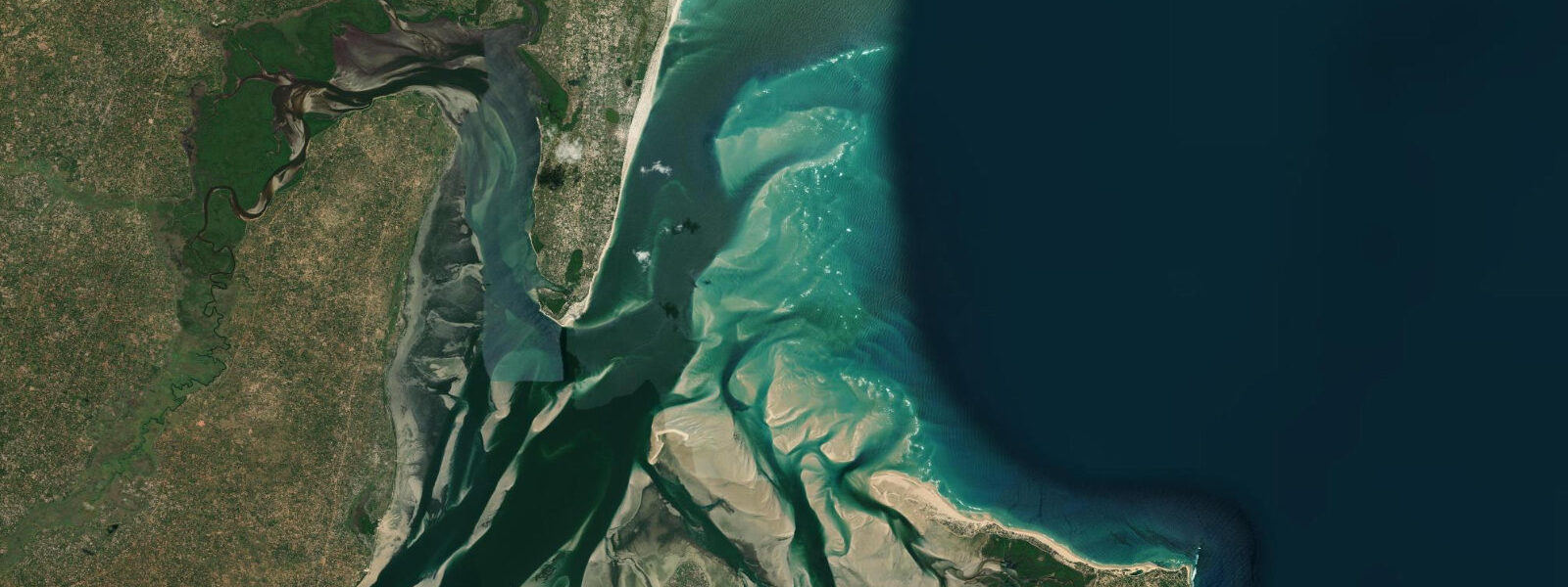
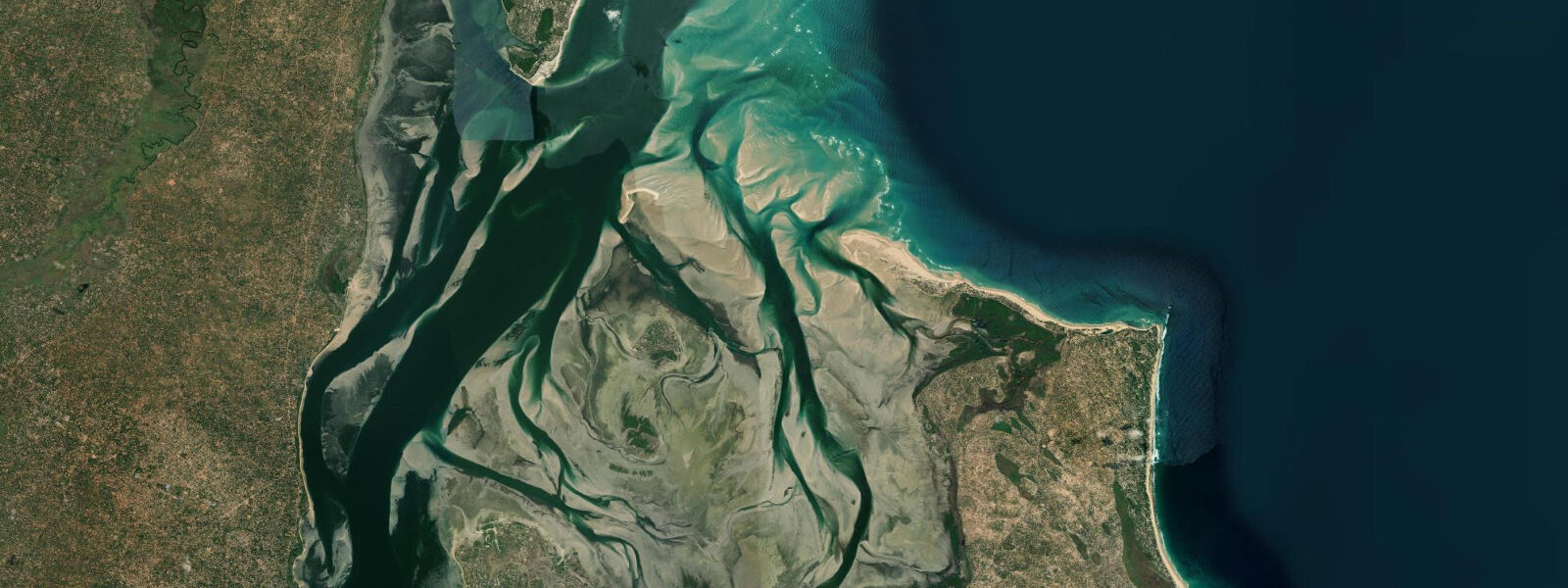
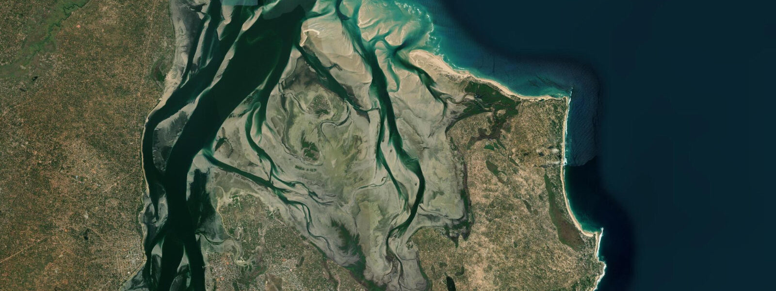
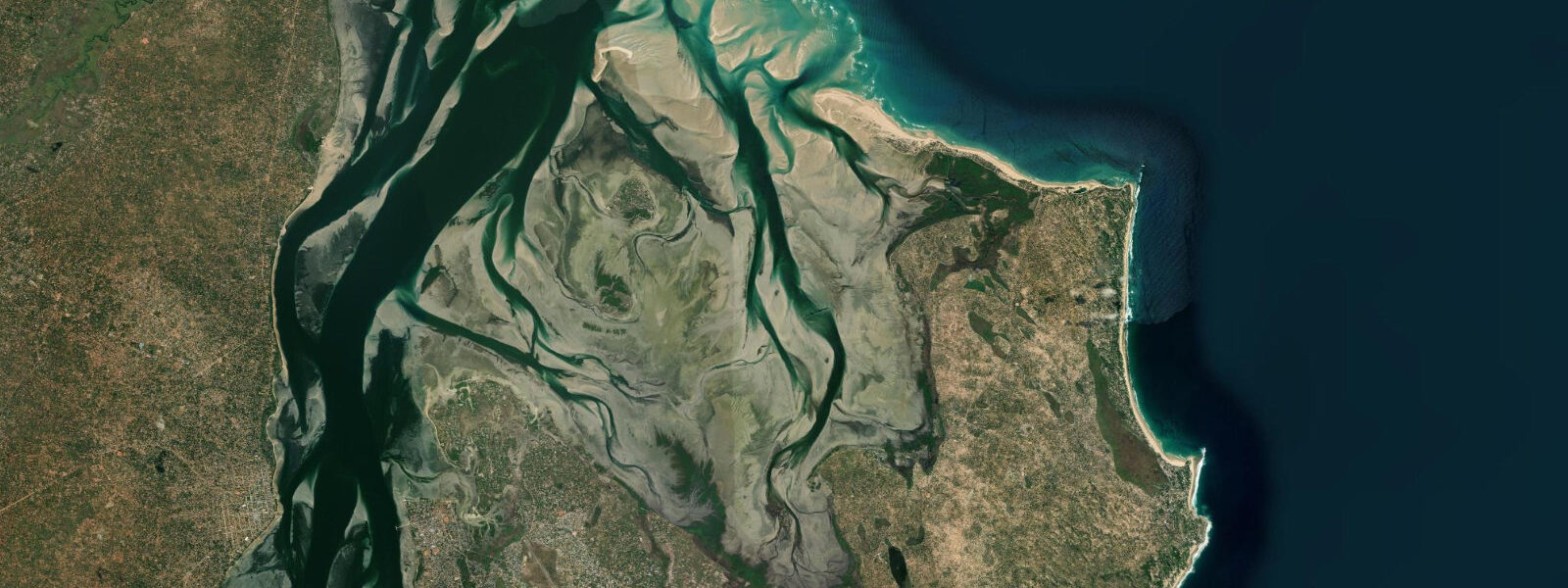
Barra Point is the tip of the Barra Peninsula, the narrow spit of land that separates Inhambane Bay from the open Indian Ocean roughly 15 kilometres northwest of Inhambane town. The lighthouse at the point marks the southern entrance to the bay — a functional navigation aid for vessels entering from the Mozambique Channel, as it has been for more than a century. The geography here is the draw: one side of the peninsula faces the sheltered water of Inhambane Bay; the other faces the open Indian Ocean.
The two environments are different enough to be treated as separate destinations, separated by a strip of land rarely more than a kilometre wide. The bay side is calm and shallow. At low water on spring tides, the bay edge shallows into extensive sand and seagrass flats where flamingos — greater flamingos (Phoenicopterus roseus) — feed in loose flocks, picking invertebrates from the soft substrate.
The flats are among the better sites in southern Mozambique for flamingo observation; numbers vary by season and water level, but regular sightings are possible between the lighthouse and the bay beach several kilometres north. Kayaking inside the bay is straightforward from mid-tide upward: the sheltered water, low current, and mangrove-fringed channels make for easy paddling. Dolphins — mainly bottlenose and humpback dolphin — work the bay interior and occasionally appear around the bay entrance channel, visible from the lighthouse promontory on calm mornings.
The bay entrance itself narrows at the lighthouse, and the tidal exchange between the bay and the channel produces a measurable current on springs — a significant ebb flow pushing south and eastward that is useful for kayakers going out with the tide but requires calculation on the return. 0 metres. The entrance current on spring ebb runs fast enough that boat operators and kayakers allow extra time to work back against it, or plan to return on the flood.
Barra Beach on the ocean side of the peninsula is a long, straight spit of white sand facing southeast. The beach is wide at low water and narrows at high tide as the Indian Ocean presses closer to the dune line. When southeast swell is running, there is a beach break along the outer spit, though the wave is inconsistent and depends heavily on swell direction and size.
More reliable than the surf is the beach itself — the outer spit is uncrowded even during Mozambican high season, and the walk along it at low tide with the channel on one side and the bay on the other gives a clear sense of the peninsula's unusual dual nature. Accommodation at Barra includes a spread of lodges and campsites, from mid-range beach resorts to budget camping. The lodge density is higher here than at Anakao but lower than at Tofo; the character of the place is more family and couple orientated than backpacker.
A tar road connects Barra to Inhambane town via Maxixe — the drive takes about 30 to 40 minutes depending on the route and ferry crossing used. The dhow ferry from Inhambane across the bay to Maxixe is an efficient option if arriving overland from the north: cross to Inhambane by ferry, then road south to Barra. The mangrove edges of Inhambane Bay are most accessible at mid to high tide; at low water the mangroves sit above exposed mud that is soft and difficult to walk.
A canoe or kayak allows access into the mangrove channels at mid-tide, and the birdlife in the channels — herons, kingfishers, the occasional African fish eagle overhead — is worth the effort. The Barra Peninsula sits between two worlds and gives easy access to both. Divers staying here can reach Tofo's manta cleaning stations in under 20 minutes by boat.
Anglers can fish the bay shallows at dawn on the incoming tide. Barra is quieter than Tofo, particularly outside South African school holiday periods, and that relative calm is its main selling point. Predictions on this page come from Open-Meteo Marine, a gridded global ocean model.
3 metres on height — model-derived, not from a local gauge. For authoritative maritime information on Mozambican waters, consult the Instituto Nacional de Hidrografia e Navegação (INAHINA).
Tide questions about Barra Point
Quick answers to the most common questions about tide times, range, and water access at Barra Point.
Where can I see flamingos at Barra Point and when?
Greater flamingos feed on the shallow tidal flats of Inhambane Bay between the Barra lighthouse and the bay beach several kilometres north. The best viewing conditions are at low water on spring tides, when the flats are exposed and the birds concentrate to feed on the soft substrate invertebrates. Numbers and locations vary; the area between the lighthouse and the mangrove edge to the north tends to be most productive. Early morning is better for light and for finding the birds before they disperse. Binoculars are useful — the flamingos work the far edges of the flats where human disturbance is minimal.
Is it safe to kayak through the bay entrance at Barra Point?
Kayaking inside Inhambane Bay from Barra is generally straightforward at mid to high tide on neap days. The bay entrance at the lighthouse narrows, and on spring tides the ebb current is strong enough to make paddling against it uncomfortable. Plan bay excursions to ride the flood in and the ebb out, not the reverse. Spring ebb through the channel mouth can run at 2 to 3 knots — manageable for fit paddlers but tiring over distance. Neap tides produce a much gentler exchange. The bay interior away from the entrance is calm regardless of tidal phase.
What is the difference between Barra Beach and the bay side?
Barra Beach faces the open Indian Ocean — it takes southeast swell, has a beach break in the right conditions, and is fully exposed to the wind. The bay side faces the interior of Inhambane Bay — sheltered, calm, shallow, and suitable for swimming, kayaking, and flamingo-watching. The two sides are separated by a strip of land rarely more than a kilometre wide. At low tide, the bay side shallows to extensive mud and sand flats; the ocean beach widens to its broadest extent. Choosing which side to use depends on conditions and purpose.
How do I get from Inhambane town to Barra Point?
The road from Inhambane town to Barra Point covers roughly 15 kilometres and takes 30 to 40 minutes by car depending on the route. From Inhambane, the route goes north to Maxixe, then south along the Barra Peninsula — or alternatively via the dhow ferry from Inhambane to Maxixe (15 minutes across the bay), then road south. Chapas run from Inhambane market toward Barra but may not reach the point directly; confirm the drop point and arrange a pickup for the return. Most Barra lodges organise transfers from Inhambane.
What is the tidal range at Barra Point and how does it affect the bay?
The spring tidal range at Barra is approximately 2.0 to 3.0 metres, consistent with the wider Inhambane estuary system. This range drives a significant exchange through the narrow bay entrance at the lighthouse on spring tides: water flooding in or draining out produces a strong current that affects boat navigation, kayaking, and the exposed area of the bay flats. At low water, the bay shallows dramatically — the flamingo flats are most accessible at this point. At high water, the mangrove channels are navigable. Neap tides halve the tidal exchange and produce much gentler conditions at the entrance.
7-day tide table — Barra Point
Heights relative to MSL. Predictions: Open-Meteo Marine (MeteoFrance SMOC, 0.08° grid) — heights relative to MSL (not chart datum / LAT). Model-derived.
| Day | Type | Time | Height |
|---|---|---|---|
| Sat 04 Jul | Low | 02:00 | -0.1m |
| High | 05:34 | 1.2m | |
| Low | 11:43 | -0.9m | |
| High | 17:55 | 1.3m | |
| Sun 05 Jul | Low | 00:06 | -0.8m |
| High | 06:06 | 1.1m | |
| Low | 12:19 | -0.8m | |
| Mon 06 Jul | High | 06:46 | 1.0m |
| Low | 12:57 | -0.8m | |
| High | 19:10 | 1.0m | |
| Tue 07 Jul | Low | 01:26 | -0.6m |
| High | 20:00 | 0.9m | |
| Wed 08 Jul | Low | 02:15 | -0.5m |
| High | 08:26 | 0.8m | |
| Low | 14:41 | -0.5m | |
| High | 21:00 | 0.8m | |
| Thu 09 Jul | Low | 03:21 | -0.4m |
| High | 09:34 | 0.7m | |
| Low | 15:55 | -0.4m | |
| High | 22:20 | 0.8m | |
| Fri 10 Jul | Low | 04:50 | -0.3m |
| High | 23:53 | 0.8m |